1507:, with the earliest historical record being of the death of miner Jacob Skinner in 1879 in his mine at the Hog Back slide. Placer mining gave way to hydraulic mining in the 1880s and continued through the 90's. The Banks (Hocumac) Mine was built in 1893 near the Baldy Notch. It was supplied with water by a mile-long pipeline, remnants of which can still be seen, running all the way from San Antonio Creek. The remains of the Gold Ridge Diggings (a.k.a. Agamemnon mine) (1897-ca. 1904) are found near the headwaters of San Antonio Canyon, in the canyon below the Ski Hut. The miners were kept supplied by sheep hunter turned merchant Fred Dell, who built Dell's Camp near the present Mt. Baldy Village, and by mule driver Fletcher Manker, who built a store at what is now known as Manker Flat. Gold mining began in Icehouse Canyon in 1892. The Hocumac and Gold Ridge mines were unsuccessful due to the uncertain water supply, the low amount of gold in the ore, and a water-pollution lawsuit filed by downslope farmers.
1321:
1516:
1735:
40:
1663:
1528:, built a resort in what is now called Stoddard Canyon. Frank Keyes converted Dell's Camp from a mining support station into a rental resort. Early mountain guide William B. Dewey led parties of guests to the summit on a loop corresponding to the present-day Mt. Baldy Trail and Devil's Backbone Trail. Rental cabins were also built in Evey Canyon. Access to the upper canyon was impeded by the precarious nature of the trail going over the Hog Back slide, but by the turn of the century Dell's Camp nevertheless entertained as many as a hundred guests in a weekend.
1544:
477:
1141:
1687:
241:
208:
234:
1496:
1675:
1460:
201:
500:
988:
1356:
1347:, depending on snow conditions. The bowl can be treacherous for inexperienced climbers as some sections have slopes of 45° to 50°. Avalanches and rock fall are both hazards, and deaths or rescues from accidents along Devil's Backbone are a common occurrence. There are also a number of summer routes to the summit involving cross-country travel or scrambling, and it is possible to rappel down the canyon of San Antonio Creek.
4836:
914:
1289:
1005:
2958:
1536:
control of the road away from
Baynham, close off the canyon with locked gates, and station armed guards to keep out intruders. But after some time and various legal battles, the company decided to profit from recreation rather than discouraging it. It bought Baynham's Camp in 1907 but then hired Baynham to manage it, charging tolls on the road from 1908 to 1922. The camp was renamed
3081:
1381:
1638:
ownership. A Zen Center was established at Manker Flats in 1971. As of 2018, the only resorts and lodges serving the general public are the Mt. Baldy Lodge and
Buckhorn Lodge in Mt. Baldy Village, and there is also a restaurant at the Baldy Notch ski area. The Snow Crest Lodge at Manker Flat is closed and being renovated.
1637:
The ski lift dates to 1952 and was expanded and modernized in 1975. As the surviving privately owned cabins in
Icehouse Canyon, Baldy Village, and Manker Flats come to the end of their 99-year leases on their lots, the Forest Service, no longer wishing to be a landlord, was converting them to private
1535:
The shift from exploitation of natural resources to recreational use of San
Antonio Canyon resulted in a series of bitter conflicts between the San Antonio Water Company and the camp owners. Pollution of the watershed and an 1899 brush fire led the company to buy Dell's Camp and close it, wrest legal
1531:
Charles
Baynham built a second camp nearby in 1907, and in the following year the canyon became accessible by automobile. In 1910, Dewey built the Baldy Summit Inn, 80 feet below the mountaintop. Despite the grand name, it consisted of only a set of tents and some storage buildings. It was damaged by
1633:
fighter planes were flying in formation in an instrument training exercise when they crashed into the west side of the summit's south ridge. Dozens of pieces of wreckage were scattered across the slope just below the present location of the Ski Hut Trail, and are not noticeable to casual observation
1551:
When the area became a national forest in 1908, the forest service began offering 99-year leases of plots of land in
Icehouse Canyon for vacation cabins. By 1938 there were 105 cabins and additional cabins at a resort owned by the Chapman family. Leases were also sold, both by the government and by
1388:
Manker Flats
Campground is available for the public to camp in on a first come-first served mechanism. It is located 3 miles northeast of Mt. Baldy Village on Mt. Baldy road, in an open pine forest. It boasts 21 campsites with features such as stoves, piped water, toilets and tables. However, there
1612:
built a lodge, also named after her, at Manker Flats in 1930. It is open to Sierra Club members. In 1935 the club added a mountain hut, known as the "ski hut," by the base of the Baldy Bowl near the headwaters of San
Antonio Creek. The ski hut burned down that year but was immediately replaced and
1363:
The ski hut is operated by the Sierra Club
Angeles Chapter and available for year-round use on weekends. It marks the approximate halfway point on the Ski Hut Trail, at an elevation of 8,200 ft. It has a fully-equipped kitchen, piped water, solar lighting, a wood-burning stove, dormitory loft beds
1625:
destroyed most of the human-made structures in Camp Baldy and
Icehouse Canyon. The casino was destroyed, but the hotel (today's Buckhorn Lodge) survived. No new building has been allowed in Icehouse Canyon, and the Icehouse Canyon resort was destroyed in 1988 by a suspicious fire. Camp Baldy was
1523:
The late 19th century saw increased interest in the area for its own qualities and for recreation rather than for its resources. In 1875 an army surveying party made the first recorded ascent to the mountain's summit, via Lytle Creek, and estimated the height of the peak. In 1880, W.H. Stoddard,
2803:
A few buildings remain, including the Buckhorn Lodge itself. The original casino burned down in 1936 and was replaced by the Wagon Wheel Casino a year later. The Wagon Wheel was across the street from the Buckhorn Lodge, with the dining room sticking out above the creek. A heated swimming pool
1371:
The hut was built by volunteers, who carried all of the building materials up on their backs; it was completed in January 1936. The original hut burned to the ground on September 20, 1936, but was rebuilt, using burros to transport the building supplies, with the replacement hut completed that
1008:
1013:
1011:
1007:
1006:
1012:
1010:
1372:
winter. The rebuilt hut is preserved as much as possible in its original condition, except that the women’s dormitory has been converted to a tool and storage room, and the failing roof panels had to be replaced, again transported to the hut by human power.
1175:
that had shown problematic behavior were moved to Southern California and released near Crystal Lake. All black bears in the San Gabriels are believed to be descended from this group. Black bears are relatively shy and are almost never known to harm humans.
1429:
Since 1965, each Labor Day, the San Antonio Canyon Town Hall has sponsored a "Run to the Top" on Mt. Baldy in which a 8-mile (13 km) course over roads and trails ends at the main peak for an approximately 4,000-foot (1,200 m) elevation gain.
1299:– (3.7 miles one way): The Icehouse Canyon trail begins in the parking lot at Icehouse and goes all the way up to Icehouse Saddle where a number of trails can be taken either to the Notch or to nearby peaks such as Ontario and Cucamonga. (5.5 miles).
459:
The mountain is almost always referred to as "Mount Baldy" by locals, to the point where many may not recognize the name "Mount San Antonio." When American settlers arrived and surveyed the land, "Baldy" – a reference to the bare fell-field of
1532:
a cooking fire in 1913 and never rebuilt. By the early 1920s there were numerous trail camps and resorts such as the Icehouse Canyon Resort, Bear Canyon Resort Eleven Oaks, Baynham Camp, Alpine Woods, Trail Inn, Snow Crest, and Kelly's Camp.
980:, in an effort to prevent future floods as severe as the one in 1938, which damaged the low-elevation, highly populated areas below. The dam succeeded in significantly reducing the damage done by the 1969 flood. Hydroelectric plants along
1163:), featured on the state flag, were once common in the Transverse Ranges, but were driven to extinction in California in the late 19th century, with one of the last animals in the San Gabriels being shot in 1894 by Walter L. Richardson.
1476:(1851), orange farmer Madison Kincaid (1865) and fruit farmer and beekeeper A.A. Dexter (ca. 1875). A sawmill was built in 1870 upstream from today's Mt. Baldy Village, but it either burned down or was destroyed in the flood of 1884.
1487:
built an icehouse there. The ice was brought down from the mountains to Los Angeles by mule and wagon and sold door to door, as well as being used at Beaudry and Marchessault's ice cream saloon, the only one in the city.
1471:
era, and was focused on exploitation of the area's resources both by independent homesteaders and for use by the populated lowland areas. Some of the first people to live permanently in the area were Mormon settlers in
4453:
1317:– (6.9 miles one way): The trail is a use trail that starts near Wrightwood but also near Wright Mountain. The trailhead is on a dirt road near Blue Ridge on CA-2. It summits 2 peaks: Dawson Peak and Pine Mountain.
1582:, the area became known as a place where one could get a drink away from the watchful eyes of the police. Former Yosemite concessionaire Foster Curry, his wife Ruth Curry, and Ruth's second husband, movie star
1368:, recognized as a superb skiing area in the early 1930s. The Ski Mountaineers section of the Sierra Club, formed in 1935, was granted permission by the U.S. Forest Service to construct a hut in this location.
1593:
built a wide trail along the Devil's Backbone from Mt. Baldy Notch to the summit, a route which had previously been narrow and dangerous due to the precipitous drops on one, or in some areas both, sides.
1305:– This trail follows the east side of the San Antonio Creek canyon to a small backcountry ski hut owned by the Sierra Club. A use trail continues around the left side of the bowl and then to the summit.
960:
Hog Back landslide lies in the canyon of San Antonio Creek at 4000' elevation. When the slide occurred, it dammed the river, whose depth built up until the water was released catastrophically, forming a
1482:
A tributary of San Antonio Creek flows through what is now known as Icehouse Canyon. Because the canyon is deep, its north-facing slope retains snow late into the spring, and in 1859 Victor Beaudry and
1239:
are difficult to distinguish visually, and firm identification may require examination of their pubic bones, but the lodgepole chipmunk has brighter white stripes. It is easier to distinguish the
561:
A weather station located around 7,700 feet was run during the 1960s; it recorded an average of 131 inches of snow per year. Snow peaks late in the season; in April 1967, 120 inches of snow fell.
1133:) are found in the area, mostly above 7000', and they lamb in the area. Their population is less threatened than those of other subspecies in California. Unlike animals of this subspecies in the
4023:
1273:– (3.5 miles one way): The trail begins at Manker Flats, where the Baldy Notch Service Road can be taken to the notch. The trail provides scenic views at the notch, and other trails ahead.
1662:
464:
that dominates the south face visible from Los Angeles – became the predominant name, and it has stuck. Nonetheless, "Mount San Antonio" is still used by a number of institutions (e.g.
1009:
4870:
4033:
105:
4865:
1202:), the jackrabbit being distinguished by its huge ears. Western gray squirrels live in oak forests at low elevations, on both the south side and the desert side of the range.
1285:– (6.5 miles one way to Mt. Baldy Summit): This is the oldest and longest trail to the summit. Because it starts at Mt. Baldy Village, it has almost 6000' of elevation gain.
1260:
Hiking trails reach the summit from four sides of the mountain, and one can access the Devil's Backbone trail by skipping the Mt. Baldy Notch trail with taking chair #1 at
4013:
1563:
542:
4880:
4018:
1686:
139:
1703:
1311:– (5.3 miles one way): The trail starts and ends at the Icehouse Canyon Trailhead. It leads to views from the summits of Thunder, Timber and Telegraph Mountains.
111:
1397:
For road cyclists, the climb through Mt. Baldy Village to the base of the ski lifts is popular. It has been used as the finish of the penultimate stage of the
233:
4890:
981:
541:
There are no roads or maintained trails connecting the mountain to the less populated region to its north, but a use trail leads over Dawson Peak and
508:
1999:
1852:
1232:) in the yellow pine forest on the south side of the range. They hibernate in winter. Rabbits may also occasionally be observed at high elevations.
4060:
1723:
973:
379:
4285:
1479:
Ever since 1882, the San Antonio Water Company has controlled the water rights in San Antonio Canyon, including its three hydroelectric plants.
4895:
4766:
3132:
1674:
2804:
adjoined the casino. The dance pavilion, picnic tables, and campsites were at the location of the present-day trout ponds. Osborne, pp. 13, 49
1389:
are no facilities for showers or sanitary disposal. Fees for camping overnight are $ 12 per night, and an additional $ 5 for extra vehicles.
200:
4082:
3812:
2625:
1645:(the abbreviation is the standard usage) has about 105 students. The visitor center is tended by unpaid volunteer rangers. As of 2013, the
1279:– (3.2 miles one way from Notch: A service road at Mt. Baldy Notch leads to the Devil's Backbone trailhead and continues to the main peak.
1040:
Higher up, the yellow pine forest community gives way to a pure lodgepole forest. Near 9,000 ft (2,750 m) these become increasingly
4385:
3141:
1990:
1843:
1708:
1515:
1320:
1087:
3092:
1734:
4666:
4240:
3283:
4885:
4646:
4165:
3900:
3648:
2066:
530:, which is in turn connected by a narrow ridge, "The Devil's Backbone," to a pass known as the Baldy Notch. At the Notch there is a
489:
371:
274:
1137:, those in the San Gabriel Mountains cannot be legally hunted and need not compete with aggressive feral burros for food or water.
523:
watershed. San Antonio Creek descends through a deep canyon which has several waterfalls, the last about 75 feet (23 m) high.
4875:
4676:
4067:
2247:
1586:, turned Camp Baldy into a playground for affluent residents of Los Angeles, with a swimming pool, casino, and a dance pavilion.
1579:
4501:
3001:
2057:
1995:
1848:
1713:
304:
2563:
4860:
4681:
4661:
4561:
4463:
4365:
4055:
4045:
1656:, a dedicated mountaineer, went missing while hiking in Mount San Antonio. His remains were found by hikers on 24 June 2023.
516:
493:
408:. The summit is accessible via a number of connecting ridges along hiking trails from the north, east, south, and southwest.
367:
270:
4716:
4686:
4641:
4636:
4420:
4250:
4092:
3942:
1021:
The lower land area of the mountain consists of an ecological community known as yellow pine forest. Tree species include
387:
4671:
4651:
4631:
4581:
4511:
4506:
4491:
4438:
4135:
4072:
3974:
1646:
132:
3085:
2097:
1459:
1063:. As the elevation increases, there is a higher ratio of chinquapin to manzanita. Other shrubs on the mountain include
4741:
4701:
4601:
4576:
4531:
4526:
4130:
3979:
1642:
1590:
1186:
are found near San Antonio Creek at low elevations, typically below 2000'. The most common species of rabbits are the
1763:
2603:
Field Trip Guidebook to San Antonio Canyon, Mount San Antonio, Cajon Pass, and Wrightwood Areas, Southern California
2529:
Field Trip Guidebook to San Antonio Canyon, Mount San Antonio, Cajon Pass, and Wrightwood Areas, Southern California
4746:
4731:
4471:
4235:
4125:
4050:
3895:
3588:
3278:
3125:
1244:
1225:
476:
39:
4736:
4726:
4721:
4711:
4706:
4696:
4691:
4626:
4621:
4616:
4611:
4586:
4566:
4556:
4516:
4496:
4481:
4476:
4410:
4008:
3922:
3910:
3688:
3110:
1622:
1567:
1210:) inhabits the San Gabriels in low-elevation areas containing manzanita, below the yellow pine forest community.
969:
465:
2878:
1543:
4591:
4571:
4546:
4521:
4486:
4380:
4335:
4245:
4215:
3986:
3959:
3954:
3805:
3638:
3558:
3523:
3503:
3258:
1140:
512:
1495:
534:, the closest one to Los Angeles. South of the resort, and connected to its ski lift by an asphalt road, lies
1985:
1838:
4816:
4756:
4751:
4606:
4596:
4551:
4541:
4536:
4315:
4110:
4038:
3964:
3927:
3917:
3868:
3358:
2341:
1728:
1537:
1473:
1468:
1418:
1410:
1406:
1402:
1398:
1187:
535:
485:
383:
17:
1267:
The trails vary in difficulty, and there are plenty of options for novices as well as experienced hikers.
4806:
4801:
4310:
4170:
4028:
3991:
3969:
3835:
3758:
3598:
3573:
3403:
3313:
3293:
550:
317:
74:
4448:
3438:
4195:
3998:
3937:
3932:
3905:
3858:
3853:
3845:
3773:
3303:
3238:
3118:
1718:
1324:
1240:
934:
531:
363:
292:
122:
87:
1203:
393:
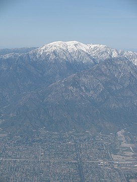
Mount San Antonio's sometimes snow-capped peaks are visible on clear days and dominate the view of the
3668:
4786:
4370:
4340:
3878:
3723:
3548:
2460:
2222:
1525:
1504:
1489:
1126:
1064:
117:
4821:
4811:
4433:
4428:
4390:
4305:
4255:
4077:
3947:
3890:
3863:
3798:
3643:
3538:
3328:
2831:
1630:
1559:
1484:
1261:
1164:
1099:
945:
system. The Transverse Ranges were formed because of a dog-leg bend in the San Andreas, which is a
546:
499:
449:
375:
1641:
Today, Mt. Baldy Village has its own fire department, church, visitor center and school district.
4796:
4375:
4330:
4325:
4320:
4175:
4145:
4120:
3718:
3698:
3628:
3508:
3498:
3188:
3098:
3052:
2272:
1414:
1145:
445:
97:
45:
3743:
480:
Map of Mt. San Antonio (main peak is labelled "Mt Baldy") and the region to the south and east.
4840:
4395:
4345:
4295:
4290:
4275:
4220:
4003:
3613:
3603:
3393:
3183:
3168:
2506:
2062:
1905:
1195:
1083:
987:
942:
938:
394:
4180:
4155:
4140:
3883:
3873:
3673:
3493:
3488:
3443:
3433:
3373:
3253:
3243:
3233:
3208:
2853:
2294:
1217:
1171:) did not naturally exist in the San Gabriel Mountains, but in 1933 eleven black bears from
1095:
1072:
453:
181:
66:
1364:
for about sixteen visitors, and an outhouse with a view. The hut is located at the base of
965:
which now holds some of the area's few good rock climbing routes (difficulty 5.11, sport).
4100:
3768:
3738:
3513:
3298:
3173:
1597:
1172:
950:
946:
520:
299:
3104:
1562:
performed a number of experiments involving bouncing a beam of light off a reflector at
1355:
386:, it is the highest point within the mountain range, the County of Los Angeles, and the
4360:
4350:
4300:
3633:
3568:
3478:
3468:
3458:
3423:
3413:
3383:
3353:
2200:
1091:
1037:. These forests are fairly sparse, and are intermixed with chaparral and oak savannah.
1022:
992:
285:
3026:
2033:
1566:, a prominence 3.2 miles (5.1 km) southwest of the peak, from the observatory at
4854:
4791:
4656:
4443:
4405:
4355:
4280:
4230:
4205:
4200:
4150:
4115:
3753:
3733:
3713:
3623:
3608:
3583:
3563:
3553:
3483:
3448:
3388:
3333:
3323:
3273:
3263:
3228:
3213:
3193:
3163:
2365:
2020:"MT BALDY NOTCH, CALIFORNIA Period of Record General Climate Summary - Precipitation"
1605:
1156:
1134:
758:
527:
433:
417:
401:
4270:
4265:
4260:
4185:
4160:
3728:
3678:
3663:
3653:
3618:
3528:
3518:
3418:
3398:
3348:
3318:
3308:
3248:
3218:
3203:
2567:
1653:
1583:
1107:
1026:
977:
334:
3198:
2979:
2019:
1759:
913:
1896:
Munro, Pamela; Brown, Nellie; Crawford, Judith G. (1992). "A Mojave dictionary".
4776:
4190:
3708:
3683:
3658:
3533:
3463:
3428:
3378:
3223:
3178:
3027:"Julian Sands: British actor identified as hiker missing in southern California"
2540:
Osborne, A guide to Mt. Baldy and San Antonio Canyon (hereinafter Osborne), p. 3
2389:
1961:
1813:
1609:
1601:
1288:
1060:
1049:
1045:
1017:
Aerial imagery of the terrain and vegetation of the slopes of Mount San Antonio.
962:
957:
917:
2178:
1785:
4400:
4225:
4210:
3825:
3821:
3763:
3748:
3593:
3578:
3543:
3473:
3453:
3368:
3363:
3343:
3288:
3268:
2439:
1937:
1365:
1336:
1335:
For mountaineers, the winter and spring offer a snow climbing challenge. The "
1103:
1041:
1034:
461:
278:
80:
3002:"Missing hiker reported in California revealed as British actor Julian Sands"
154:
141:
4781:
3693:
3338:
3158:
1909:
1556:
1068:
1056:
1030:
488:. Its summit is 10,064 feet (3,068 m), and marks the boundary between
176:
3080:
1809:
953:
to move smoothly past one another, and mountains were raised as a result.
3703:
1927:
Sierra Club Hundred Peaks Section, 100 Peaks Lookout newsletter, May 1969
1340:
1236:
1115:
1872:
1668:
Looking northwest at Baldy Summit from Devil's Backbone near Mt. Harwood
4105:
3778:
2937:
2893:
2427:
Woman on the Rocks – The Moutaineering Letters of Ruth Dyar Mendenhall.
397:
322:
3790:
2772:
north of Ontario Peak, now an undeveloped camping area for backpackers
27:
Highest peak of the San Gabriel Mountains in California, United States
3153:
2727:
1921, located behind the present-day fire station. Osborne, pp. 5, 56
1519:
Dell's Summit Inn, just below the top of the mountain, ca. 1910–1913.
1344:
1213:
1183:
1179:
1111:
1079:
921:
359:
58:
2718:
1921, on the site of the present-day Mr. Baldy Lodge, Osborne, p. 57
3053:"Remains Located in the Mt. Baldy Wilderness Area on June 24, 2023"
1438:
Dogs are legal in Angeles National Forest, but must be on a leash.
2316:
1733:
1542:
1514:
1494:
1458:
1380:
1379:
1354:
1319:
1287:
1139:
1003:
986:
912:
498:
475:
405:
2686:
Afoot and Afield Los Angeles County: A Comprehensive Hiking Guide
2130:
Vaughan, Mammals of the San Gabriel Mountains of California, 1954
1738:
Mt. Baldy visible from Los Angeles’ Ballona Creek on a clear day
1247:, which is spotted and has a gray area on the back of its neck.
3794:
3114:
1692:
Panorama looking south toward Los Angeles just below the summit
3142:
The 126 most prominent summits of the United States of America
2916:
2827:
1503:
Gold mining did not begin in the area until decades after the
1044:, and beyond about 9,500 ft (2,900 m) lies an unforested
2828:"Mt. Baldy History and Ice House Canyon « profmason.com"
1446:
Hunting is allowed, but is regulated and requires a license.
2906:
on the site of the former Bear Canyon Resort, Osborne, p. 57
2342:"Hiking Mt. Baldy via the Ski Hut Trail (Baldy Bowl Trail)"
1634:
from the trail only because they are overgrown with brush.
1608:, a subsidiary peak of Mount Baldy, is named for her. The
1243:(gray, with a white belly and a big, bushy tail) from the
1118:
vestita, a type of mountainparsley, is adapted to talus.
1499:
Fletcher Manker, in his uniform as fire chief of Upland.
496:. A sub-peak, West Baldy, is 9,996 feet (3,047 m).
2248:"Mt. Baldy deaths lead to questions about trail safety"
1629:
During a snow storm on March 2, 1949, two Marine Corps
1463:
A group of hunters at the summit of Mt. Baldy, ca. 1890
1216:
found at higher elevations in the San Gabriels include
2484:
2390:"Sierra Club Angeles Chapter Ski Mountaineers Section"
1904:. Los Angeles: University of California, Los Angeles.
341:
Ski lift to Baldy Notch, Devil's Backbone Trail (hike)
1649:
does not have any paid rangers on duty in the area.
4765:
4462:
4419:
4091:
3844:
2673:
Trails of the Angels: 100 Hikes in the San Gabriels
2084:
California Forests and Woodlands: A Natural History
1052:trees grow on the slopes above San Antonio Creek.
400:. The peak and a subsidiary one to the west form a
333:
328:
316:
311:
298:
284:
266:
187:
175:
170:
131:
96:
92:
42.52 mi (68.43 km) → San Bernardino Peak
86:
73:
57:
52:
32:
2959:"Angeles National Forest Mt. Baldy Visitor Center"
2154:Mammals of the San Gabriel Mountains of California
1938:"Official Boundaries of the County of Los Angeles"
1552:the water company, at Camp Baldy and Manker Flat.
1055:The dominant shrubs at the higher elevations are
933:Mount San Antonio lies in the front range of the
2745:1930, below Icehouse Canyon; burned down in 1938
2412:Brinton, Bob. 1945. Encyclimpedia Brintonica,
519:. San Antonio and Lytle Creeks are part of the
4871:Mountains of San Bernardino County, California
3105:Destruction at Camp Baldy after the 1938 flood
3093:Mt. Baldy Visitor Center and Interpretive Site
2763:near Manker Flat, closed and for sale ca. 2012
2441:The Historic Ski Hut on Mount Baldy | KTLA 360
1758:United States Geological Survey (2018-10-22).
1704:List of highest points in California by county
1467:The first development in the area came in the
968:In modern times, notable floods have occurred
507:The mountain's southern watershed drains into
3806:
3126:
2126:
2124:
2122:
2120:
2118:
8:
2564:"Explore Historic California September 2011"
1753:
1751:
1626:rebuilt and later became Mt. Baldy Village.
1384:Manker Flats Campground on Mount San Antonio
1339:" south of the summit is often climbed with
1224:), all the way up to the tree line, and the
976:was completed in 1956, after a pause due to
18:Mount Baldy (Los Angeles County, California)
4866:Mountains of Los Angeles County, California
2179:"Dan's Hiking Pages: Introducing Mt. Baldy"
3813:
3799:
3791:
3133:
3119:
3111:
2601:National Association of Geology Teachers,
2527:National Association of Geology Teachers,
991:A cluster of pollen-bearing male cones of
949:. The bend makes it difficult for the two
941:of Southern California, formed around the
564:
452:circa 1840, in honor of his patron saint,
44:South face of Mt. San Antonio, seen above
29:
2566:. Explorehistoricalif.com. Archived from
1923:
1921:
1919:
240:
207:
2590:Los Angeles in Civil War Days, 1860–1865
2000:United States Department of the Interior
1853:United States Department of the Interior
4881:San Gabriel Mountains National Monument
1747:
1724:San Gabriel Mountains National Monument
1680:Looking southwest from Mt. Baldy Summit
1658:
995:on Mount San Antonio at around 8,500 ft
380:San Gabriel Mountains National Monument
1833:
1831:
1829:
1652:On 13 January 2023, the English actor
503:San Antonio Creek on Mount San Antonio
2429:Bishop, CA: Spotted Dog Press, p. 23.
2394:skimountaineerssectionlachaptersc.org
1898:UCLA Occasional Papers in Linguistics
1029:(also known as western yellow pine),
448:, owner of a rancho near present-day
358:, is a 10,064 ft (3,068 m)
253:Mount San Antonio (the United States)
67:The National Map of the United States
7:
2938:"Welcome to Mt Baldy Village Church"
1760:"The National Map – Advanced Viewer"
1600:, the first female president of the
2854:"US Navy and US Marine Corps BuNos"
2754:1927, a mile inside Icehouse Canyon
2507:"Angeles National Forest – Hunting"
1991:Geographic Names Information System
1844:Geographic Names Information System
1709:List of Ultras of the United States
4286:Sacramento–San Joaquin River Delta
2061:. University of California Press.
25:
3000:Beckett, Lois (19 January 2023).
2273:"Mount San Antonio (Mount Baldy)"
2034:"MOUNT BALDY, CALIFORNIA (91759)"
1873:"Mount San Antonio (Mount Baldy)"
1570:some 22 miles (35 km) away.
1524:brother-in-law of railroad baron
1492:was later mayor of Los Angeles.)
4891:Mountains of Southern California
4834:
4444:Riverside–San Bernardino–Ontario
3079:
2879:"Mount Baldy – Hellcats 7/21/06"
2815:101 Hikes in Southern California
1685:
1673:
1661:
1574:Prohibition and Great Depression
1421:as the fifth stage of the race.
239:
232:
206:
199:
38:
3099:Mount San Antonio (Mount Baldy)
2883:Joe Idoni: Photo Hiking Journal
2834:from the original on 2013-09-28
2295:"San Antonio Falls (Mt. Baldy)"
2246:Hurt, Suzanne (17 March 2017).
2141:A Natural History of California
2058:A Natural History of California
1996:United States Geological Survey
1849:United States Geological Survey
1714:Mt. Baldy Joint School District
1555:Between 1922 and 1927 American
1292:Fall color on Mount San Antonio
984:are tied to the electric grid.
79:6,224 ft (1,897 m) ↓
4454:San Jose–San Francisco–Oakland
4434:Los Angeles-Long Beach-Anaheim
1417:. It was also featured in the
1:
4896:North American 3000 m summits
2425:Mendenhall, Ruth Dyar. 2007.
2340:Robinson, Drew (2017-06-06).
2317:"Sierra Club Angeles Chapter"
2055:Schoenherr, Allan A. (1992).
1547:Motorists at Camp Baldy, 1919
831:Average snowfall inches (cm)
388:Los Angeles metropolitan area
256:Show map of the United States
112:California county high points
63:10,064 ft (3,068 m)
2531:(hereinafter NAGT), pp. 3–37
2485:"Mount Baldy Run to the Top"
1810:"Hundred Peaks Section List"
924:Boulder on Mount San Antonio
484:Mt. San Antonio lies in the
4014:National Historic Landmarks
2709:opened 1919, Osborne, p. 68
2624:Trent, D.D. (August 1986).
2370:Sierra Club Angeles Chapter
1591:Civilian Conservation Corps
1078:Wildflower species include
687:Mean daily minimum °F (°C)
617:Mean daily maximum °F (°C)
568:Climate data for Mt. Baldy
545:to Wright Mountain and the
404:of a steep-sided east–west
4912:
4019:National Natural Landmarks
3095:. Angeles National Forest.
2982:. Mt Baldy School District
2940:. Mtbaldyvillagechurch.com
2917:"Mt Baldy Fire Department"
1604:, was active in the area.
1245:California ground squirrel
1226:California ground squirrel
900:
567:
549:, overlooking the town of
350:, commonly referred to as
155:34.2888927°N 117.6467218°W
4830:
4034:congressional delegations
3832:
3689:Mount Cleveland (Montana)
3148:
2626:"Mount Baldy Mining Area"
2461:"Recreation at Mt. Baldy"
2223:"Recreation at Mt. Baldy"
1455:Exploitation of resources
830:
756:
686:
616:
611:
608:
605:
602:
599:
596:
593:
590:
587:
584:
581:
578:
575:
572:
515:and the Fish Fork of the
466:Mount San Antonio College
444:was probably bestowed by
192:
37:
4886:Landmarks in Los Angeles
4336:Santa Clara River Valley
4061:state historic landmarks
3559:Mount Cleveland (Alaska)
3524:Mount Jefferson (Oregon)
3504:Mount Jefferson (Nevada)
2736:near today's trout pools
2167:Mammals of North America
1962:"West Baldy, California"
1613:remains standing today.
1230:Otospermophilus beecheyi
160:34.2888927; -117.6467218
4876:Angeles National Forest
4316:San Francisco Peninsula
4111:California Coast Ranges
2781:Kimberly J. Creighton,
1729:Mt. San Antonio College
1419:2017 Tour of California
1359:Mt. Baldy Hut 1937–1938
1188:black-tailed jackrabbit
1131:Ovis canadensis nelsoni
486:Angeles National Forest
384:Angeles National Forest
106:US most prominent peaks
4386:Southern Border Region
4311:San Francisco Bay Area
4196:Greater San Bernardino
4166:East Bay (SF Bay Area)
2321:angeles.sierraclub.org
1739:
1548:
1520:
1500:
1464:
1385:
1360:
1327:
1293:
1153:
1018:
996:
925:
526:East of the summit is
511:, the north side into
504:
481:
223:Show map of California
220:Location in California
182:Saint Anthony of Padua
4861:San Gabriel Mountains
4841:California portal
3239:San Gorgonio Mountain
3088:at Wikimedia Commons
2366:"San Antonio Ski Hut"
2203:. Mount Baldy Resorts
1737:
1719:Mount Baldy Ski Lifts
1546:
1518:
1498:
1462:
1383:
1358:
1331:Winter mountaineering
1323:
1291:
1241:western gray squirrel
1143:
1016:
990:
935:San Gabriel Mountains
916:
502:
490:San Bernardino County
479:
364:San Gabriel Mountains
293:San Gabriel Mountains
123:Hundred Peaks Section
4439:Sacramento–Roseville
4341:Santa Clarita Valley
3724:Abercrombie Mountain
3549:Great Sitkin Volcano
2698:Trails of the Angels
2570:on 24 September 2015
2551:Trails Of the Angels
1617:After the 1938 flood
1526:Collis P. Huntington
1505:California Gold Rush
1315:North Backbone Trail
1200:Sylvilagus audubonii
1127:Desert bighorn sheep
1084:San Gabriel alumroot
4391:Southern California
4306:San Fernando Valley
4256:Northern California
4216:Greater Los Angeles
3329:White Mountain Peak
2416:. Oct 4 and Nov. 1.
2098:"Mount San Antonio"
2082:Johnston, Verna R.
1986:"San Antonio Falls"
1942:Los Angeles Almanac
1839:"Mount San Antonio"
1812:. Angeles Chapter,
1786:"Mount San Antonio"
1560:Albert A. Michelson
1485:Damien Marchessault
1264:during any season.
1262:Mount Baldy Resorts
1235:The two species of
1222:Neotamias speciosus
1218:lodgepole chipmunks
1150:Neotamias speciosus
1073:mountain gooseberry
1065:mountain whitethorn
547:Pacific Crest Trail
378:. Lying within the
151: /
4331:Santa Clara Valley
4326:San Joaquin Valley
4321:San Gabriel Valley
4176:Eastern California
4146:Coastal California
4121:Central California
3589:Sierra Blanca Peak
3499:Sovereign Mountain
3209:Shishaldin Volcano
3189:Mount Marcus Baker
2860:. February 3, 2019
2671:John W. Robinson,
2633:California Geology
2614:Osborne, pp. 5, 62
2588:John W. Robinson,
1740:
1549:
1521:
1501:
1474:Lytle Creek Canyon
1465:
1415:Tour of California
1386:
1361:
1328:
1325:Mt. Baldy ski area
1294:
1208:Neotamias merriami
1204:Merriam's chipmunk
1192:Lepus californicus
1154:
1146:lodgepole chipmunk
1100:Nuttall's sandwort
1019:
997:
926:
505:
494:Los Angeles County
482:
446:Antonio Maria Lugo
420:call the mountain
53:Highest point
46:Upland, California
4848:
4847:
4449:San Diego–Tijuana
4396:Transverse Ranges
4346:Santa Ynez Valley
4296:Saddleback Valley
4291:Sacramento Valley
4276:Peninsular Ranges
4251:North County (SD)
4221:Los Angeles Basin
4083:Index of articles
3788:
3787:
3639:Flat Top Mountain
3614:North Schell Peak
3409:Mount San Antonio
3184:Mount Saint Elias
3169:Mount Fairweather
3101:. SummitPost.org.
3086:Mount San Antonio
3084:Media related to
3059:. 28 January 2023
3033:. 19 January 2023
2980:"Mt Baldy School"
2919:. Mtbaldyfire.com
2830:. Profmason.com.
2181:. Simpsoncity.com
2165:Kays and Wilson,
2036:. weather channel
1589:In 1935–1936 the
1196:desert cottontail
1106:. There are also
1096:Parry's pussypaws
1092:pumice alpinegold
1050:Mountain mahogany
1014:
982:San Antonio Creek
943:San Andreas Fault
939:Transverse Ranges
905:
904:
517:San Gabriel River
509:San Antonio Creek
442:Mount San Antonio
395:Los Angeles Basin
366:on the border of
348:Mount San Antonio
345:
344:
307:Mount San Antonio
247:Mount San Antonio
214:Mount San Antonio
33:Mount San Antonio
16:(Redirected from
4903:
4839:
4838:
4837:
4181:Emerald Triangle
4171:East County (SD)
4156:Cucamonga Valley
4141:Coachella Valley
3884:California Dream
3874:California sound
3815:
3808:
3801:
3792:
3674:Mount Timpanogos
3669:Carlisle Volcano
3494:Makushin Volcano
3444:Mount Washington
3434:Pogromni Volcano
3374:Mount Chiginagak
3254:Mount Veniaminof
3234:San Jacinto Peak
3135:
3128:
3121:
3112:
3083:
3069:
3068:
3066:
3064:
3049:
3043:
3042:
3040:
3038:
3023:
3017:
3016:
3014:
3012:
2997:
2991:
2990:
2988:
2987:
2976:
2970:
2969:
2967:
2966:
2955:
2949:
2948:
2946:
2945:
2934:
2928:
2927:
2925:
2924:
2913:
2907:
2904:
2898:
2897:
2891:
2889:
2875:
2869:
2868:
2866:
2865:
2850:
2844:
2843:
2841:
2839:
2824:
2818:
2811:
2805:
2801:
2795:
2792:
2786:
2779:
2773:
2770:
2764:
2761:
2755:
2752:
2746:
2743:
2737:
2734:
2728:
2725:
2719:
2716:
2710:
2707:
2701:
2694:
2688:
2682:
2676:
2669:
2663:
2660:
2654:
2651:
2645:
2644:
2642:
2640:
2630:
2621:
2615:
2612:
2606:
2599:
2593:
2586:
2580:
2579:
2577:
2575:
2560:
2554:
2547:
2541:
2538:
2532:
2525:
2519:
2518:
2516:
2514:
2503:
2497:
2496:
2494:
2492:
2481:
2475:
2474:
2472:
2470:
2465:
2457:
2451:
2450:
2449:
2448:
2436:
2430:
2423:
2417:
2410:
2404:
2403:
2401:
2400:
2386:
2380:
2379:
2377:
2376:
2362:
2356:
2355:
2353:
2352:
2337:
2331:
2330:
2328:
2327:
2313:
2307:
2306:
2304:
2302:
2297:. Canyonbeta.com
2291:
2285:
2284:
2282:
2280:
2275:. Summitpost.org
2269:
2263:
2262:
2260:
2258:
2243:
2237:
2236:
2234:
2232:
2227:
2219:
2213:
2212:
2210:
2208:
2197:
2191:
2190:
2188:
2186:
2175:
2169:
2163:
2157:
2150:
2144:
2137:
2131:
2128:
2113:
2112:
2110:
2108:
2094:
2088:
2087:
2079:
2073:
2072:
2052:
2046:
2045:
2043:
2041:
2030:
2024:
2023:
2016:
2010:
2009:
2007:
2006:
1982:
1976:
1975:
1973:
1972:
1958:
1952:
1951:
1949:
1948:
1934:
1928:
1925:
1914:
1913:
1893:
1887:
1886:
1884:
1883:
1869:
1863:
1862:
1860:
1859:
1835:
1824:
1823:
1821:
1820:
1806:
1800:
1799:
1797:
1796:
1782:
1776:
1775:
1773:
1772:
1765:The National Map
1755:
1689:
1677:
1665:
1643:Mt. Baldy School
1564:Lookout Mountain
1277:Devil's Backbone
1169:Ursus americanus
1015:
565:
536:Mt Baldy Village
454:Anthony of Padua
337:
288:
257:
243:
242:
236:
224:
210:
209:
203:
166:
165:
163:
162:
161:
156:
152:
149:
148:
147:
144:
42:
30:
21:
4911:
4910:
4906:
4905:
4904:
4902:
4901:
4900:
4851:
4850:
4849:
4844:
4835:
4833:
4826:
4768:
4761:
4667:San Luis Obispo
4458:
4415:
4236:Mountain Empire
4136:Channel Islands
4101:Antelope Valley
4087:
4051:Protected areas
3840:
3828:
3819:
3789:
3784:
3783:
3769:Korovin Volcano
3739:Chiricahua Peak
3634:Veniaminof Peak
3514:Isanotski Peaks
3299:Mount Tom White
3274:Iliamna Volcano
3244:Charleston Peak
3214:Redoubt Volcano
3174:Mount Blackburn
3144:
3139:
3077:
3072:
3062:
3060:
3051:
3050:
3046:
3036:
3034:
3025:
3024:
3020:
3010:
3008:
2999:
2998:
2994:
2985:
2983:
2978:
2977:
2973:
2964:
2962:
2957:
2956:
2952:
2943:
2941:
2936:
2935:
2931:
2922:
2920:
2915:
2914:
2910:
2905:
2901:
2887:
2885:
2877:
2876:
2872:
2863:
2861:
2852:
2851:
2847:
2837:
2835:
2826:
2825:
2821:
2812:
2808:
2802:
2798:
2793:
2789:
2780:
2776:
2771:
2767:
2762:
2758:
2753:
2749:
2744:
2740:
2735:
2731:
2726:
2722:
2717:
2713:
2708:
2704:
2695:
2691:
2683:
2679:
2670:
2666:
2661:
2657:
2652:
2648:
2638:
2636:
2628:
2623:
2622:
2618:
2613:
2609:
2600:
2596:
2587:
2583:
2573:
2571:
2562:
2561:
2557:
2549:John Robinson,
2548:
2544:
2539:
2535:
2526:
2522:
2512:
2510:
2505:
2504:
2500:
2490:
2488:
2483:
2482:
2478:
2468:
2466:
2463:
2459:
2458:
2454:
2446:
2444:
2438:
2437:
2433:
2424:
2420:
2411:
2407:
2398:
2396:
2388:
2387:
2383:
2374:
2372:
2364:
2363:
2359:
2350:
2348:
2339:
2338:
2334:
2325:
2323:
2315:
2314:
2310:
2300:
2298:
2293:
2292:
2288:
2278:
2276:
2271:
2270:
2266:
2256:
2254:
2245:
2244:
2240:
2230:
2228:
2225:
2221:
2220:
2216:
2206:
2204:
2199:
2198:
2194:
2184:
2182:
2177:
2176:
2172:
2164:
2160:
2151:
2147:
2138:
2134:
2129:
2116:
2106:
2104:
2096:
2095:
2091:
2081:
2080:
2076:
2069:
2054:
2053:
2049:
2039:
2037:
2032:
2031:
2027:
2018:
2017:
2013:
2004:
2002:
1984:
1983:
1979:
1970:
1968:
1960:
1959:
1955:
1946:
1944:
1936:
1935:
1931:
1926:
1917:
1895:
1894:
1890:
1881:
1879:
1871:
1870:
1866:
1857:
1855:
1837:
1836:
1827:
1818:
1816:
1808:
1807:
1803:
1794:
1792:
1784:
1783:
1779:
1770:
1768:
1757:
1756:
1749:
1745:
1700:
1693:
1690:
1681:
1678:
1669:
1666:
1619:
1598:Aurelia Harwood
1576:
1513:
1457:
1452:
1444:
1436:
1427:
1395:
1378:
1353:
1351:Sierra Club hut
1333:
1297:Icehouse Canyon
1283:Mt. Baldy Trail
1271:Mt. Baldy Notch
1258:
1253:
1173:Yosemite Valley
1124:
1088:gray monardella
1061:bush chinquapin
1004:
1002:
974:San Antonio Dam
947:transform fault
931:
911:
909:Natural history
906:
895:
890:
885:
880:
875:
870:
865:
860:
855:
850:
845:
840:
835:
825:
820:
815:
810:
805:
800:
795:
790:
785:
780:
775:
770:
765:
751:
746:
741:
736:
731:
726:
721:
716:
711:
706:
701:
696:
691:
681:
676:
671:
666:
661:
656:
651:
646:
641:
636:
631:
626:
621:
559:
521:Santa Ana River
474:
438:Avii Kwatiinyam
414:
335:
286:
279:California U.S.
262:
261:
260:
259:
258:
255:
254:
251:
250:
249:
248:
244:
227:
226:
225:
222:
221:
218:
217:
216:
215:
211:
159:
157:
153:
150:
145:
142:
140:
138:
137:
127:
64:
48:
28:
23:
22:
15:
12:
11:
5:
4909:
4907:
4899:
4898:
4893:
4888:
4883:
4878:
4873:
4868:
4863:
4853:
4852:
4846:
4845:
4831:
4828:
4827:
4825:
4824:
4819:
4814:
4809:
4804:
4799:
4794:
4789:
4784:
4779:
4773:
4771:
4763:
4762:
4760:
4759:
4754:
4749:
4744:
4739:
4734:
4729:
4724:
4719:
4714:
4709:
4704:
4699:
4694:
4689:
4684:
4679:
4674:
4669:
4664:
4659:
4654:
4649:
4647:San Bernardino
4644:
4639:
4634:
4629:
4624:
4619:
4614:
4609:
4604:
4599:
4594:
4589:
4584:
4579:
4574:
4569:
4564:
4559:
4554:
4549:
4544:
4539:
4534:
4529:
4524:
4519:
4514:
4509:
4504:
4499:
4494:
4489:
4484:
4479:
4474:
4468:
4466:
4460:
4459:
4457:
4456:
4451:
4446:
4441:
4436:
4431:
4425:
4423:
4417:
4416:
4414:
4413:
4408:
4403:
4398:
4393:
4388:
4383:
4378:
4376:South Bay (SF)
4373:
4371:South Bay (SD)
4368:
4366:South Bay (LA)
4363:
4361:Silicon Valley
4358:
4353:
4351:Shasta Cascade
4348:
4343:
4338:
4333:
4328:
4323:
4318:
4313:
4308:
4303:
4301:Salinas Valley
4298:
4293:
4288:
4283:
4278:
4273:
4268:
4263:
4258:
4253:
4248:
4243:
4241:North Bay (SF)
4238:
4233:
4228:
4223:
4218:
4213:
4208:
4203:
4198:
4193:
4188:
4183:
4178:
4173:
4168:
4163:
4158:
4153:
4148:
4143:
4138:
4133:
4131:Central Valley
4128:
4123:
4118:
4113:
4108:
4103:
4097:
4095:
4089:
4088:
4086:
4085:
4080:
4075:
4073:Transportation
4070:
4065:
4064:
4063:
4058:
4048:
4043:
4042:
4041:
4036:
4026:
4021:
4016:
4011:
4006:
4001:
3996:
3995:
3994:
3984:
3983:
3982:
3977:
3972:
3967:
3962:
3952:
3951:
3950:
3945:
3940:
3935:
3925:
3920:
3915:
3914:
3913:
3903:
3898:
3893:
3888:
3887:
3886:
3881:
3876:
3871:
3866:
3861:
3850:
3848:
3842:
3841:
3833:
3830:
3829:
3820:
3818:
3817:
3810:
3803:
3795:
3786:
3785:
3782:
3781:
3776:
3771:
3766:
3761:
3756:
3751:
3746:
3741:
3736:
3731:
3726:
3721:
3716:
3711:
3706:
3701:
3696:
3691:
3686:
3681:
3676:
3671:
3666:
3661:
3656:
3651:
3646:
3641:
3636:
3631:
3626:
3621:
3616:
3611:
3606:
3601:
3596:
3591:
3586:
3581:
3576:
3571:
3569:Mount Wrangell
3566:
3561:
3556:
3551:
3546:
3541:
3536:
3531:
3526:
3521:
3516:
3511:
3506:
3501:
3496:
3491:
3489:Tanaga Volcano
3486:
3481:
3479:Mount Natazhat
3476:
3471:
3469:Humphreys Peak
3466:
3461:
3459:Mount Mitchell
3456:
3451:
3446:
3441:
3436:
3431:
3426:
3424:Telescope Peak
3421:
3416:
3414:Kichatna Spire
3411:
3406:
3401:
3396:
3391:
3386:
3384:Sacajawea Peak
3381:
3376:
3371:
3366:
3361:
3359:Mount Hesperus
3356:
3354:Mount Vsevidof
3351:
3346:
3341:
3336:
3331:
3326:
3321:
3316:
3311:
3306:
3301:
3296:
3291:
3286:
3281:
3276:
3271:
3266:
3261:
3256:
3251:
3249:Pavlof Volcano
3246:
3241:
3236:
3231:
3226:
3221:
3216:
3211:
3206:
3201:
3196:
3191:
3186:
3181:
3176:
3171:
3166:
3161:
3156:
3150:
3149:
3146:
3145:
3140:
3138:
3137:
3130:
3123:
3115:
3109:
3108:
3102:
3096:
3076:
3075:External links
3073:
3071:
3070:
3044:
3018:
2992:
2971:
2950:
2929:
2908:
2899:
2870:
2858:joebaugher.com
2845:
2819:
2806:
2796:
2794:NAGT, pp. 3–38
2787:
2774:
2765:
2756:
2747:
2738:
2729:
2720:
2711:
2702:
2689:
2677:
2664:
2662:Osborne, p. 62
2655:
2646:
2616:
2607:
2594:
2581:
2555:
2542:
2533:
2520:
2498:
2476:
2452:
2431:
2418:
2405:
2381:
2357:
2332:
2308:
2286:
2264:
2252:Daily Bulletin
2238:
2214:
2201:"Scenic Rides"
2192:
2170:
2158:
2145:
2143:, pp. 216, 515
2132:
2114:
2089:
2086:. p. 158.
2074:
2067:
2047:
2025:
2011:
1977:
1966:Peakbagger.com
1953:
1929:
1915:
1888:
1877:SummitPost.org
1864:
1825:
1801:
1790:Peakbagger.com
1777:
1746:
1744:
1741:
1732:
1731:
1726:
1721:
1716:
1711:
1706:
1699:
1696:
1695:
1694:
1691:
1684:
1682:
1679:
1672:
1670:
1667:
1660:
1647:Forest Service
1618:
1615:
1575:
1572:
1512:
1509:
1456:
1453:
1451:
1448:
1443:
1440:
1435:
1432:
1426:
1423:
1394:
1391:
1377:
1374:
1352:
1349:
1332:
1329:
1257:
1254:
1252:
1249:
1123:
1120:
1023:lodgepole pine
1001:
998:
993:lodgepole pine
972:and 1969. The
930:
927:
910:
907:
903:
902:
898:
897:
892:
887:
882:
877:
872:
867:
862:
857:
852:
847:
842:
837:
832:
828:
827:
822:
817:
812:
807:
802:
797:
792:
787:
782:
777:
772:
767:
762:
754:
753:
748:
743:
738:
733:
728:
723:
718:
713:
708:
703:
698:
693:
688:
684:
683:
678:
673:
668:
663:
658:
653:
648:
643:
638:
633:
628:
623:
618:
614:
613:
610:
607:
604:
601:
598:
595:
592:
589:
586:
583:
580:
577:
574:
570:
569:
563:
558:
555:
473:
470:
428:, which means
413:
410:
372:San Bernardino
343:
342:
339:
331:
330:
326:
325:
320:
314:
313:
309:
308:
302:
296:
295:
290:
282:
281:
275:San Bernardino
268:
264:
263:
252:
246:
245:
238:
237:
231:
230:
229:
228:
219:
213:
212:
205:
204:
198:
197:
196:
195:
194:
193:
190:
189:
185:
184:
179:
173:
172:
168:
167:
135:
129:
128:
126:
125:
120:
115:
109:
102:
100:
94:
93:
90:
84:
83:
77:
71:
70:
61:
55:
54:
50:
49:
43:
35:
34:
26:
24:
14:
13:
10:
9:
6:
4:
3:
2:
4908:
4897:
4894:
4892:
4889:
4887:
4884:
4882:
4879:
4877:
4874:
4872:
4869:
4867:
4864:
4862:
4859:
4858:
4856:
4843:
4842:
4829:
4823:
4820:
4818:
4815:
4813:
4810:
4808:
4805:
4803:
4800:
4798:
4795:
4793:
4792:San Francisco
4790:
4788:
4785:
4783:
4780:
4778:
4775:
4774:
4772:
4770:
4767:Most populous
4764:
4758:
4755:
4753:
4750:
4748:
4745:
4743:
4740:
4738:
4735:
4733:
4730:
4728:
4725:
4723:
4720:
4718:
4715:
4713:
4710:
4708:
4705:
4703:
4700:
4698:
4695:
4693:
4690:
4688:
4685:
4683:
4680:
4678:
4677:Santa Barbara
4675:
4673:
4670:
4668:
4665:
4663:
4660:
4658:
4657:San Francisco
4655:
4653:
4650:
4648:
4645:
4643:
4640:
4638:
4635:
4633:
4630:
4628:
4625:
4623:
4620:
4618:
4615:
4613:
4610:
4608:
4605:
4603:
4600:
4598:
4595:
4593:
4590:
4588:
4585:
4583:
4580:
4578:
4575:
4573:
4570:
4568:
4565:
4563:
4560:
4558:
4555:
4553:
4550:
4548:
4545:
4543:
4540:
4538:
4535:
4533:
4530:
4528:
4525:
4523:
4520:
4518:
4515:
4513:
4510:
4508:
4505:
4503:
4500:
4498:
4495:
4493:
4490:
4488:
4485:
4483:
4480:
4478:
4475:
4473:
4470:
4469:
4467:
4465:
4461:
4455:
4452:
4450:
4447:
4445:
4442:
4440:
4437:
4435:
4432:
4430:
4429:Fresno–Madera
4427:
4426:
4424:
4422:
4421:Metro regions
4418:
4412:
4409:
4407:
4406:Victor Valley
4404:
4402:
4399:
4397:
4394:
4392:
4389:
4387:
4384:
4382:
4379:
4377:
4374:
4372:
4369:
4367:
4364:
4362:
4359:
4357:
4356:Sierra Nevada
4354:
4352:
4349:
4347:
4344:
4342:
4339:
4337:
4334:
4332:
4329:
4327:
4324:
4322:
4319:
4317:
4314:
4312:
4309:
4307:
4304:
4302:
4299:
4297:
4294:
4292:
4289:
4287:
4284:
4282:
4281:Pomona Valley
4279:
4277:
4274:
4272:
4269:
4267:
4264:
4262:
4259:
4257:
4254:
4252:
4249:
4247:
4244:
4242:
4239:
4237:
4234:
4232:
4231:Mojave Desert
4229:
4227:
4224:
4222:
4219:
4217:
4214:
4212:
4209:
4207:
4206:Klamath Basin
4204:
4202:
4201:Inland Empire
4199:
4197:
4194:
4192:
4189:
4187:
4184:
4182:
4179:
4177:
4174:
4172:
4169:
4167:
4164:
4162:
4159:
4157:
4154:
4152:
4151:Conejo Valley
4149:
4147:
4144:
4142:
4139:
4137:
4134:
4132:
4129:
4127:
4126:Central Coast
4124:
4122:
4119:
4117:
4116:Cascade Range
4114:
4112:
4109:
4107:
4104:
4102:
4099:
4098:
4096:
4094:
4090:
4084:
4081:
4079:
4076:
4074:
4071:
4069:
4066:
4062:
4059:
4057:
4054:
4053:
4052:
4049:
4047:
4044:
4040:
4037:
4035:
4032:
4031:
4030:
4027:
4025:
4024:NRHP listings
4022:
4020:
4017:
4015:
4012:
4010:
4007:
4005:
4002:
4000:
3997:
3993:
3990:
3989:
3988:
3985:
3981:
3980:Supreme Court
3978:
3976:
3973:
3971:
3968:
3966:
3963:
3961:
3958:
3957:
3956:
3953:
3949:
3946:
3944:
3941:
3939:
3936:
3934:
3931:
3930:
3929:
3926:
3924:
3921:
3919:
3916:
3912:
3909:
3908:
3907:
3904:
3902:
3899:
3897:
3894:
3892:
3889:
3885:
3882:
3880:
3877:
3875:
3872:
3870:
3867:
3865:
3862:
3860:
3857:
3856:
3855:
3852:
3851:
3849:
3847:
3843:
3838:
3837:
3831:
3827:
3823:
3816:
3811:
3809:
3804:
3802:
3797:
3796:
3793:
3780:
3777:
3775:
3772:
3770:
3767:
3765:
3762:
3760:
3757:
3755:
3754:Mount Augusta
3752:
3750:
3747:
3745:
3742:
3740:
3737:
3735:
3734:Mount Gareloi
3732:
3730:
3727:
3725:
3722:
3720:
3717:
3715:
3714:Mount Deborah
3712:
3710:
3707:
3705:
3702:
3700:
3697:
3695:
3692:
3690:
3687:
3685:
3682:
3680:
3677:
3675:
3672:
3670:
3667:
3665:
3662:
3660:
3657:
3655:
3652:
3650:
3649:Mount Steller
3647:
3645:
3644:Bearhole Peak
3642:
3640:
3637:
3635:
3632:
3630:
3627:
3625:
3624:Mount Foresta
3622:
3620:
3617:
3615:
3612:
3610:
3609:Snowshoe Peak
3607:
3605:
3602:
3600:
3599:Mount Russell
3597:
3595:
3592:
3590:
3587:
3585:
3584:Mount Seattle
3582:
3580:
3577:
3575:
3572:
3570:
3567:
3565:
3564:McDonald Peak
3562:
3560:
3557:
3555:
3552:
3550:
3547:
3545:
3542:
3540:
3537:
3535:
3532:
3530:
3527:
3525:
3522:
3520:
3517:
3515:
3512:
3510:
3507:
3505:
3502:
3500:
3497:
3495:
3492:
3490:
3487:
3485:
3484:Hanagita Peak
3482:
3480:
3477:
3475:
3472:
3470:
3467:
3465:
3462:
3460:
3457:
3455:
3452:
3450:
3449:Mount Igikpak
3447:
3445:
3442:
3440:
3437:
3435:
3432:
3430:
3427:
3425:
3422:
3420:
3417:
3415:
3412:
3410:
3407:
3405:
3404:Mount Douglas
3402:
3400:
3397:
3395:
3392:
3390:
3389:Mount Neacola
3387:
3385:
3382:
3380:
3377:
3375:
3372:
3370:
3367:
3365:
3362:
3360:
3357:
3355:
3352:
3350:
3347:
3345:
3342:
3340:
3337:
3335:
3334:Mount Crillon
3332:
3330:
3327:
3325:
3324:Mount Foraker
3322:
3320:
3317:
3315:
3314:Mount Kimball
3312:
3310:
3307:
3305:
3302:
3300:
3297:
3295:
3294:Mount Sanford
3292:
3290:
3287:
3285:
3282:
3280:
3279:Mount Olympus
3277:
3275:
3272:
3270:
3267:
3265:
3264:Mount Hubbard
3262:
3260:
3257:
3255:
3252:
3250:
3247:
3245:
3242:
3240:
3237:
3235:
3232:
3230:
3229:Mount Torbert
3227:
3225:
3222:
3220:
3217:
3215:
3212:
3210:
3207:
3205:
3202:
3200:
3197:
3195:
3194:Mount Whitney
3192:
3190:
3187:
3185:
3182:
3180:
3177:
3175:
3172:
3170:
3167:
3165:
3164:Mount Rainier
3162:
3160:
3157:
3155:
3152:
3151:
3147:
3143:
3136:
3131:
3129:
3124:
3122:
3117:
3116:
3113:
3106:
3103:
3100:
3097:
3094:
3091:
3090:
3089:
3087:
3082:
3074:
3058:
3054:
3048:
3045:
3032:
3028:
3022:
3019:
3007:
3003:
2996:
2993:
2981:
2975:
2972:
2961:. Fs.usda.gov
2960:
2954:
2951:
2939:
2933:
2930:
2918:
2912:
2909:
2903:
2900:
2895:
2884:
2880:
2874:
2871:
2859:
2855:
2849:
2846:
2833:
2829:
2823:
2820:
2816:
2810:
2807:
2800:
2797:
2791:
2788:
2784:
2778:
2775:
2769:
2766:
2760:
2757:
2751:
2748:
2742:
2739:
2733:
2730:
2724:
2721:
2715:
2712:
2706:
2703:
2699:
2693:
2690:
2687:
2684:Jerry Schad,
2681:
2678:
2674:
2668:
2665:
2659:
2656:
2650:
2647:
2635:. p. 179
2634:
2627:
2620:
2617:
2611:
2608:
2604:
2598:
2595:
2591:
2585:
2582:
2569:
2565:
2559:
2556:
2552:
2546:
2543:
2537:
2534:
2530:
2524:
2521:
2509:. Fs.usda.gov
2508:
2502:
2499:
2487:. Run2top.com
2486:
2480:
2477:
2462:
2456:
2453:
2443:
2442:
2435:
2432:
2428:
2422:
2419:
2415:
2409:
2406:
2395:
2391:
2385:
2382:
2371:
2367:
2361:
2358:
2347:
2346:Trail to Peak
2343:
2336:
2333:
2322:
2318:
2312:
2309:
2296:
2290:
2287:
2274:
2268:
2265:
2253:
2249:
2242:
2239:
2224:
2218:
2215:
2202:
2196:
2193:
2180:
2174:
2171:
2168:
2162:
2159:
2155:
2149:
2146:
2142:
2136:
2133:
2127:
2125:
2123:
2121:
2119:
2115:
2103:
2099:
2093:
2090:
2085:
2078:
2075:
2070:
2068:0-520-06922-6
2064:
2060:
2059:
2051:
2048:
2035:
2029:
2026:
2021:
2015:
2012:
2001:
1997:
1993:
1992:
1987:
1981:
1978:
1967:
1963:
1957:
1954:
1943:
1939:
1933:
1930:
1924:
1922:
1920:
1916:
1911:
1907:
1903:
1899:
1892:
1889:
1878:
1874:
1868:
1865:
1854:
1850:
1846:
1845:
1840:
1834:
1832:
1830:
1826:
1815:
1811:
1805:
1802:
1791:
1787:
1781:
1778:
1767:
1766:
1761:
1754:
1752:
1748:
1742:
1736:
1730:
1727:
1725:
1722:
1720:
1717:
1715:
1712:
1710:
1707:
1705:
1702:
1701:
1697:
1688:
1683:
1676:
1671:
1664:
1659:
1657:
1655:
1650:
1648:
1644:
1639:
1635:
1632:
1627:
1624:
1623:flood of 1938
1616:
1614:
1611:
1607:
1606:Mount Harwood
1603:
1599:
1595:
1592:
1587:
1585:
1581:
1573:
1571:
1569:
1565:
1561:
1558:
1553:
1545:
1541:
1539:
1533:
1529:
1527:
1517:
1510:
1508:
1506:
1497:
1493:
1491:
1490:Marchesseault
1486:
1480:
1477:
1475:
1470:
1461:
1454:
1449:
1447:
1441:
1439:
1433:
1431:
1424:
1422:
1420:
1416:
1412:
1408:
1404:
1400:
1392:
1390:
1382:
1375:
1373:
1369:
1367:
1357:
1350:
1348:
1346:
1342:
1338:
1330:
1326:
1322:
1318:
1316:
1312:
1310:
1306:
1304:
1303:Ski Hut Trail
1300:
1298:
1290:
1286:
1284:
1280:
1278:
1274:
1272:
1268:
1265:
1263:
1255:
1250:
1248:
1246:
1242:
1238:
1233:
1231:
1227:
1223:
1219:
1215:
1211:
1209:
1205:
1201:
1197:
1193:
1189:
1185:
1181:
1177:
1174:
1170:
1166:
1162:
1158:
1157:Grizzly bears
1151:
1147:
1142:
1138:
1136:
1135:Mojave Desert
1132:
1128:
1121:
1119:
1117:
1113:
1109:
1105:
1101:
1097:
1093:
1089:
1085:
1081:
1076:
1074:
1070:
1066:
1062:
1058:
1053:
1051:
1047:
1043:
1038:
1036:
1032:
1028:
1024:
999:
994:
989:
985:
983:
979:
975:
971:
966:
964:
959:
954:
952:
948:
944:
940:
937:, one of the
936:
928:
923:
919:
915:
908:
899:
893:
888:
883:
878:
873:
868:
863:
858:
853:
848:
843:
838:
833:
829:
823:
818:
813:
808:
803:
798:
793:
788:
783:
778:
773:
768:
763:
760:
759:precipitation
755:
749:
744:
739:
734:
729:
724:
719:
714:
709:
704:
699:
694:
689:
685:
679:
674:
669:
664:
659:
654:
649:
644:
639:
634:
629:
624:
619:
615:
571:
566:
562:
556:
554:
552:
548:
544:
543:Pine Mountain
539:
537:
533:
529:
528:Mount Harwood
524:
522:
518:
514:
510:
501:
497:
495:
491:
487:
478:
471:
469:
467:
463:
457:
455:
451:
447:
443:
439:
435:
431:
427:
423:
419:
411:
409:
407:
403:
402:double summit
399:
396:
391:
389:
385:
381:
377:
373:
369:
365:
361:
357:
353:
349:
340:
338:
336:Easiest route
332:
327:
324:
321:
319:
318:Mountain type
315:
310:
306:
303:
301:
297:
294:
291:
289:
283:
280:
276:
272:
269:
265:
235:
202:
191:
186:
183:
180:
178:
174:
169:
164:
136:
134:
130:
124:
121:
119:
116:
113:
110:
107:
104:
103:
101:
99:
95:
91:
89:
85:
82:
78:
76:
72:
69:
68:
62:
60:
56:
51:
47:
41:
36:
31:
19:
4832:
4502:Contra Costa
4411:Wine Country
4271:Oxnard Plain
4266:Owens Valley
4261:Orange Coast
4186:Gold Country
4161:Death Valley
3896:Demographics
3834:
3729:Mount Lemmon
3679:Bashful Peak
3664:Mount Miller
3654:Mount Stuart
3619:Hayford Peak
3574:South Sister
3529:Isthmus Peak
3519:Deseret Peak
3419:De Long Peak
3408:
3399:Mount Graham
3349:Gannett Peak
3319:Mount Griggs
3309:Glacier Peak
3304:Wheeler Peak
3219:Mount Elbert
3204:Mount Shasta
3078:
3061:. Retrieved
3056:
3047:
3035:. Retrieved
3030:
3021:
3009:. Retrieved
3006:The Guardian
3005:
2995:
2984:. Retrieved
2974:
2963:. Retrieved
2953:
2942:. Retrieved
2932:
2921:. Retrieved
2911:
2902:
2892:– via
2886:. Retrieved
2882:
2873:
2862:. Retrieved
2857:
2848:
2836:. Retrieved
2822:
2814:
2809:
2799:
2790:
2782:
2777:
2768:
2759:
2750:
2741:
2732:
2723:
2714:
2705:
2697:
2692:
2685:
2680:
2672:
2667:
2658:
2649:
2637:. Retrieved
2632:
2619:
2610:
2602:
2597:
2589:
2584:
2572:. Retrieved
2568:the original
2558:
2550:
2545:
2536:
2528:
2523:
2511:. Retrieved
2501:
2489:. Retrieved
2479:
2467:. Retrieved
2455:
2445:, retrieved
2440:
2434:
2426:
2421:
2413:
2408:
2397:. Retrieved
2393:
2384:
2373:. Retrieved
2369:
2360:
2349:. Retrieved
2345:
2335:
2324:. Retrieved
2320:
2311:
2299:. Retrieved
2289:
2277:. Retrieved
2267:
2255:. Retrieved
2251:
2241:
2229:. Retrieved
2217:
2207:September 2,
2205:. Retrieved
2195:
2183:. Retrieved
2173:
2166:
2161:
2153:
2148:
2140:
2139:Schoenherr,
2135:
2105:. Retrieved
2101:
2092:
2083:
2077:
2056:
2050:
2038:. Retrieved
2028:
2014:
2003:. Retrieved
1989:
1980:
1969:. Retrieved
1965:
1956:
1945:. Retrieved
1941:
1932:
1901:
1897:
1891:
1880:. Retrieved
1876:
1867:
1856:. Retrieved
1842:
1817:. Retrieved
1804:
1793:. Retrieved
1789:
1780:
1769:. Retrieved
1764:
1654:Julian Sands
1651:
1640:
1636:
1628:
1620:
1596:
1588:
1584:Edmund Burns
1577:
1568:Mount Wilson
1554:
1550:
1534:
1530:
1522:
1502:
1481:
1478:
1466:
1445:
1437:
1428:
1396:
1387:
1370:
1362:
1334:
1314:
1313:
1308:
1307:
1302:
1301:
1296:
1295:
1282:
1281:
1276:
1275:
1270:
1269:
1266:
1259:
1234:
1229:
1221:
1212:
1207:
1199:
1191:
1178:
1168:
1161:Ursus arctos
1160:
1155:
1149:
1130:
1125:
1108:Ross's sedge
1077:
1054:
1039:
1027:Jeffrey pine
1020:
978:World War II
967:
955:
932:
920:San Gabriel
761:inches (mm)
560:
540:
525:
506:
483:
458:
441:
437:
429:
425:
421:
415:
392:
374:counties of
355:
351:
347:
346:
287:Parent range
118:Three Saints
65:
4817:Bakersfield
4777:Los Angeles
4682:Santa Clara
4662:San Joaquin
4562:Los Angeles
4381:South Coast
4246:North Coast
4191:Great Basin
4056:state parks
4009:LGBT rights
3975:legislature
3923:Environment
3911:agriculture
3901:Earthquakes
3774:Miller Peak
3759:Copper Peak
3719:Necons Peak
3709:Lassen Peak
3699:Tetlin Peak
3684:Ibapah Peak
3659:Blanca Peak
3534:Frosty Peak
3509:Mount Ellen
3464:Truuli Peak
3429:Mount Peale
3379:Grand Teton
3259:Mount Adams
3224:Mount Baker
3179:Mount Hayes
2888:February 8,
2838:12 December
2639:February 8,
2574:12 December
2513:12 December
2491:12 December
2301:12 December
2279:12 December
2185:12 December
2107:12 December
1814:Sierra Club
1610:Sierra Club
1602:Sierra Club
1580:Prohibition
1165:Black bears
1046:alpine zone
1042:krummholzed
1033:, and some
963:slot canyon
958:prehistoric
918:Proterozoic
513:Lytle Creek
440:. The name
368:Los Angeles
352:Mount Baldy
271:Los Angeles
158: /
146:117°38′48″W
133:Coordinates
4855:Categories
4807:Long Beach
4802:Sacramento
4717:Stanislaus
4687:Santa Cruz
4642:San Benito
4637:Sacramento
4401:Tri-Valley
4226:Lost Coast
4211:Lake Tahoe
3987:Healthcare
3955:Government
3836:Sacramento
3826:California
3764:Mount Bear
3749:Mount Eddy
3744:Stony Peak
3604:Mount Nebo
3594:Pikes Peak
3579:Devils Paw
3554:Puʻu Kukui
3544:Crazy Peak
3539:Pilot Peak
3474:Borah Peak
3454:Snow Tower
3439:Dewey Peak
3394:Kings Peak
3369:Mount Drum
3364:Mount Bona
3344:Cloud Peak
3289:Mount Hood
3284:Mount Cook
3269:Mount Isto
3063:28 January
3037:19 January
3011:19 January
2986:2009-08-14
2965:2012-12-30
2944:2012-12-30
2923:2012-12-30
2864:2019-02-08
2696:Robinson,
2605:, pp. 3–37
2447:2022-08-11
2399:2022-08-11
2375:2022-08-11
2351:2022-08-11
2326:2022-08-11
2040:10 October
2005:2009-08-14
1971:2009-08-14
1947:2008-08-30
1882:2017-01-10
1858:2019-09-16
1819:2016-08-10
1795:2009-01-25
1771:2020-07-09
1743:References
1538:Camp Baldy
1511:Resort era
1366:Baldy Bowl
1337:Baldy Bowl
1251:Recreation
1194:) and the
1104:caulanthus
1082:parishii,
1035:sugar pine
551:Wrightwood
532:ski resort
462:Baldy Bowl
432:, and the
376:California
277:counties,
143:34°17′20″N
81:Cajon Pass
75:Prominence
4782:San Diego
4672:San Mateo
4652:San Diego
4632:Riverside
4582:Mendocino
4512:El Dorado
4507:Del Norte
4492:Calaveras
4039:elections
3965:districts
3928:Geography
3918:Education
3869:languages
3839:(capital)
3694:Kawaikini
3629:Star Peak
3339:Mauna Loa
3199:Haleakalā
3159:Mauna Kea
2783:Mt. Baldy
2414:Mugelnoos
2152:Vaughan,
1557:physicist
1540:in 1910.
1469:Civil War
1309:Three T’s
1112:rockcress
1069:buckwheat
1057:manzanita
1031:white fir
901:Source:
472:Geography
356:Old Baldy
188:Geography
177:Etymology
88:Isolation
59:Elevation
4787:San Jose
4742:Tuolumne
4702:Siskiyou
4602:Monterey
4577:Mariposa
4532:Imperial
4527:Humboldt
4464:Counties
4029:Politics
3992:Abortion
3970:governor
3704:Arc Dome
3107:. Flickr
3031:BBC News
2832:Archived
2700:, p. 201
2675:, p. 201
2553:, p. 230
2469:12 March
2257:31 March
2231:18 March
1910:28561333
1698:See also
1341:crampons
1237:chipmunk
1116:Oreonana
896:(417.6)
826:(1,140)
757:Average
436:call it
329:Climbing
323:Granitic
300:Topo map
267:Location
4822:Anaheim
4812:Oakland
4747:Ventura
4732:Trinity
4472:Alameda
4106:Big Sur
4093:Regions
4068:Symbols
3999:History
3960:Capitol
3938:ecology
3933:climate
3906:Economy
3854:Culture
3779:Kamakou
3057:Twitter
2894:SmugMug
2817:, p. 82
2813:Schad,
2785:, p. 55
2592:, p. 19
2102:BioHere
1762:(Map).
1631:Hellcat
1578:During
1450:History
1442:Hunting
1425:Running
1393:Cycling
1376:Camping
1214:Rodents
1184:coyotes
1180:Rabbits
1122:Animals
970:in 1938
929:Geology
557:Climate
450:Compton
398:skyline
362:in the
312:Geology
98:Listing
4797:Fresno
4769:cities
4737:Tulare
4727:Tehama
4722:Sutter
4712:Sonoma
4707:Solano
4697:Sierra
4692:Shasta
4627:Plumas
4622:Placer
4617:Orange
4612:Nevada
4587:Merced
4567:Madera
4557:Lassen
4517:Fresno
4497:Colusa
4482:Amador
4477:Alpine
4046:People
3879:sports
3846:Topics
3154:Denali
2156:, 1954
2065:
1908:
1413:Amgen
1345:ice ax
1256:Trails
1102:, and
1080:Galium
1071:, and
1000:Plants
951:plates
922:Gneiss
881:(2.5)
876:(0.0)
871:(0.0)
866:(0.0)
861:(0.0)
856:(5.1)
841:(110)
821:(150)
801:(8.1)
791:(8.9)
781:(110)
776:(169)
771:(258)
766:(226)
747:(−11)
697:(−11)
692:(−10)
573:Month
434:Mohave
418:Tongva
360:summit
171:Naming
4592:Modoc
4572:Marin
4547:Kings
4522:Glenn
4487:Butte
4078:Water
3948:fauna
3943:flora
3891:Crime
3864:music
3822:State
2653:Trent
2629:(PDF)
2464:(PDF)
2226:(PDF)
894:163.9
891:(65)
886:(27)
851:(43)
846:(83)
836:(82)
824:44.87
816:(79)
811:(55)
806:(15)
796:(18)
786:(43)
769:10.14
752:(−4)
742:(−8)
737:(−4)
712:(−3)
707:(−7)
702:(−8)
682:(10)
667:(11)
662:(16)
657:(19)
652:(20)
647:(17)
642:(12)
612:Year
406:ridge
4757:Yuba
4752:Yolo
4607:Napa
4597:Mono
4552:Lake
4542:Kern
4537:Inyo
3859:food
3065:2023
3039:2023
3013:2023
2890:2019
2840:2014
2641:2019
2576:2014
2515:2014
2493:2014
2471:2020
2303:2014
2281:2014
2259:2020
2233:2020
2209:2023
2187:2014
2109:2014
2063:ISBN
2042:2017
1906:OCLC
1621:The
1434:Dogs
1411:2019
1409:and
1407:2015
1403:2012
1399:2011
1343:and
1182:and
1110:and
1059:and
956:The
889:25.4
884:10.5
849:16.8
844:32.5
839:43.5
834:32.2
819:5.89
814:3.11
809:2.17
804:0.59
799:0.32
794:0.72
789:0.35
784:1.70
779:4.33
774:6.65
764:8.90
732:(1)
727:(3)
722:(4)
717:(2)
677:(2)
672:(6)
637:(7)
632:(4)
627:(2)
622:(2)
609:Dec
606:Nov
603:Oct
600:Sep
597:Aug
594:Jul
591:Jun
588:May
585:Apr
582:Mar
579:Feb
576:Jan
492:and
430:snow
426:Joat
422:Yoát
416:The
412:Name
382:and
370:and
305:USGS
114:14th
108:52nd
4004:Law
3824:of
879:1.0
874:0.0
869:0.0
864:0.0
859:0.0
854:2.0
468:).
424:or
354:or
4857::
3055:.
3029:.
3004:.
2881:.
2856:.
2631:.
2392:.
2368:.
2344:.
2319:.
2250:.
2117:^
2100:.
1998:,
1994:.
1988:.
1964:.
1940:.
1918:^
1902:10
1900:.
1875:.
1851:,
1847:.
1841:.
1828:^
1788:.
1750:^
1405:,
1401:,
1144:A
1114:.
1098:,
1094:,
1090:,
1086:,
1075:.
1067:,
1048:.
1025:,
750:24
745:13
740:18
735:24
730:33
725:38
720:39
715:35
710:27
705:20
700:17
695:13
690:14
680:50
675:36
670:43
665:52
660:61
655:67
650:68
645:63
640:53
635:44
630:39
625:35
620:36
553:.
538:.
456:.
390:.
273:/
3814:e
3807:t
3800:v
3134:e
3127:t
3120:v
3067:.
3041:.
3015:.
2989:.
2968:.
2947:.
2926:.
2896:.
2867:.
2842:.
2643:.
2578:.
2517:.
2495:.
2473:.
2402:.
2378:.
2354:.
2329:.
2305:.
2283:.
2261:.
2235:.
2211:.
2189:.
2111:.
2071:.
2044:.
2022:.
2008:.
1974:.
1950:.
1912:.
1885:.
1861:.
1822:.
1798:.
1774:.
1488:(
1228:(
1220:(
1206:(
1198:(
1190:(
1167:(
1159:(
1152:)
1148:(
1129:(
20:)
Text is available under the Creative Commons Attribution-ShareAlike License. Additional terms may apply.