127:
134:
306:
36:
126:
83:
453:
438:
299:
at higher altitudes. After rain, climbing the mountain can be dangerous due to slippery rocks and the path's proximity to sheer cliffs.
423:
289:
69:
235:
169:
76:
278:
458:
251:
259:
191:
227:
393:
274:
181:
243:
64:
363:
385:
419:
311:
295:
The easiest path to the summit is via the south-eastern track which passes through stands of
296:
335:
162:
447:
41:
206:
301:
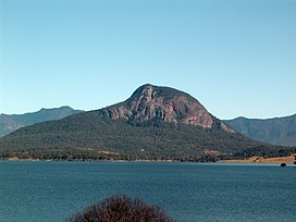
255:
247:
146:
98:
85:
231:
150:
35:
239:
223:
54:
285:
273:. In 1828, the mountain was named after the Scottish botanist
238:. It lies approximately 100 km (62 mi) south west of
234:. The mountain rises 720 m above sea level and is part of the
364:"Moogerah Peaks National Park — Nature, culture and history"
284:
Palm Gorge is situated on Mount
Greville. This narrow
205:
200:
190:
180:
175:
161:
114:
75:
63:
53:
48:
23:
265:The local Uragapul people call this mountain,
8:
133:
20:
324:
358:
356:
330:
328:
222:is a cone-shaped and deeply fissured
7:
16:Mountain in the country of Australia
336:"Topographic map of Mount Greville"
454:Mountains of South East Queensland
14:
304:
288:contains a nearly pure stand of
246:. Other prominent peaks in this
132:
125:
34:
396:. 13 December 1930. p. 15
1:
439:Moogerah Peaks National Park
418:. Rankin Publishers. pp. 50
250:group of mountains includes
236:Moogerah Peaks National Park
386:"West Moreton's Wonderland"
271:place where the eagles rest
40:Mount Greville viewed from
475:
59:772 m (2,533 ft)
416:Secrets of the Scenic Rim
366:. The State of Queensland
277:by the European explorer
242:just outside the town of
119:
33:
28:
414:Rankin, Robert. (1992)
99:28.07453°S 152.50265°E
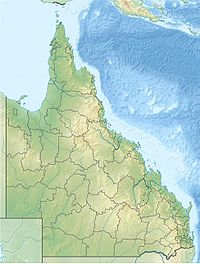
70:Mountains of Australia
228:South East Queensland
394:The Queensland Times
275:Robert Kaye Greville
104:-28.07453; 152.50265
140:Mount Greville
95: /
24:Mount Greville
49:Highest point
459:Scenic Rim Region
312:Queensland portal
217:
216:
466:
426:
412:
406:
405:
403:
401:
390:trove.nla.gov.au
382:
376:
375:
373:
371:
360:
351:
350:
348:
346:
332:
314:
309:
308:
307:
279:Allan Cunningham
213:South-east track
209:
186:23 million years
165:
136:
135:
129:
110:
109:
107:
106:
105:
100:
96:
93:
92:
91:
88:
38:
21:
474:
473:
469:
468:
467:
465:
464:
463:
444:
443:
435:
430:
429:
413:
409:
399:
397:
384:
383:
379:
369:
367:
362:
361:
354:
344:
342:
340:opentopomap.org
334:
333:
326:
321:
310:
305:
303:
297:Eucalyptus dura
290:Piccabeen Palms
207:
163:
157:
156:
155:
154:
153:
144:
143:
142:
141:
137:
103:
101:
97:
94:
89:
86:
84:
82:
81:
44:
17:
12:
11:
5:
472:
470:
462:
461:
456:
446:
445:
442:
441:
434:
433:External links
431:
428:
427:
407:
377:
352:
323:
322:
320:
317:
316:
315:
220:Mount Greville
215:
214:
211:
203:
202:
198:
197:
194:
188:
187:
184:
178:
177:
173:
172:
170:Moogerah Peaks
167:
159:
158:
145:
139:
138:
131:
130:
124:
123:
122:
121:
120:
117:
116:
112:
111:
79:
73:
72:
67:
61:
60:
57:
51:
50:
46:
45:
39:
31:
30:
26:
25:
15:
13:
10:
9:
6:
4:
3:
2:
471:
460:
457:
455:
452:
451:
449:
440:
437:
436:
432:
425:
424:0-9592418-3-3
421:
417:
411:
408:
395:
391:
387:
381:
378:
365:
359:
357:
353:
341:
337:
331:
329:
325:
318:
313:
302:
300:
298:
293:
291:
287:
282:
280:
276:
272:
268:
263:
261:
257:
253:
252:Mount Edwards
249:
245:
241:
237:
233:
229:
225:
221:
212:
210:
208:Easiest route
204:
199:
196:Volcanic plug
195:
193:
192:Mountain type
189:
185:
183:
179:
174:
171:
168:
166:
160:
152:
148:
128:
118:
113:
108:
80:
78:
74:
71:
68:
66:
62:
58:
56:
52:
47:
43:
42:Lake Moogerah
37:
32:
27:
22:
19:
415:
410:
398:. Retrieved
389:
380:
368:. Retrieved
343:. Retrieved
339:
294:
283:
270:
267:Meebatboogan
266:
264:
260:Mount French
219:
218:
164:Parent range
29:Meebatboogan
18:
182:Age of rock
102: /
90:152°30′10″E
77:Coordinates
448:Categories
319:References
269:, meaning
256:Mount Moon
248:Scenic Rim
147:Queensland
87:28°04′28″S
232:Australia
151:Australia
115:Geography
55:Elevation
370:7 August
240:Brisbane
224:mountain
201:Climbing
400:12 June
345:12 June
176:Geology
65:Listing
422:
244:Boonah
286:gorge
420:ISBN
402:2023
372:2009
347:2023
258:and
226:in
450::
392:.
388:.
355:^
338:.
327:^
292:.
281:.
262:.
254:,
230:,
149:,
404:.
374:.
349:.
Text is available under the Creative Commons Attribution-ShareAlike License. Additional terms may apply.