208:
175:
201:
483:
168:
29:
459:, and travel east toward the Sierra Nevada mountains. As fronts approach, they are forced upward by the peaks, causing them to drop their moisture in the form of rain or snowfall onto the range (
106:
496:
667:
672:
682:
593:
200:
687:
677:
584:
384:
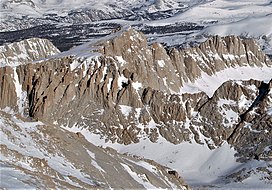
traverses below the south aspect of the mountain, providing approach access. Mt. Hale ranks as the 63rd-highest summit in
California.
167:
652:
589:
271:
401:
99:
388:
is significant as the north aspect rises 1,770 feet (540 meters) above Wales Lake in approximately one-quarter mile.
633:
429:
361:
241:
421:
409:
579:
344:
298:
64:
54:
377:
369:
237:
77:
69:
92:
628:
286:
612:
405:
385:
310:
148:
87:
408:(1868–1938), best known for his discovery of magnetic fields in sunspots, and founder of the
488:
439:
of the summit was made July 24, 1934, by J. H. Czock and
Mildred Czock via the south slope.
460:
425:
381:
356:
is a 13,494-foot-elevation (4,113-meter) mountain summit located west of the crest of the
266:
412:. The immediate area has other geographical features named after astronomers, including
464:
448:
252:
661:
456:
452:
417:
413:
373:
357:
259:
436:
337:
327:
397:
303:
28:
519:
478:
468:
365:
291:
245:
613:
John D. and Ruth
Mendenhall, Arthur B. Johnson, Braeme Gigas, Howard Koster,
121:
108:
143:
376:, one mile northeast of Mount Young, and 0.85 mile west-southwest of
315:
550:
44:
336:
326:
321:
309:
297:
285:
280:
265:
251:
233:
154:
142:
137:
98:
86:
76:
63:
53:
43:
38:
21:
497:List of the major 4000-meter summits of California
545:
543:
541:
539:
8:
18:
404:to honor the eminent American astronomer
396:This mountain's name was proposed by the
594:United States Department of the Interior
508:
668:Mountains of Tulare County, California
574:
572:
570:
467:from this mountain drains west to the
400:and officially adopted in 1940 by the
7:
615:A Climber’s Guide to the High Sierra
514:
512:
585:Geographic Names Information System
380:, the nearest higher neighbor. The
16:Mountain in the state of California
673:Mountains of Sequoia National Park
207:
174:
14:
683:Mountains of Northern California
481:
471:via Wallace and Whitney Creeks.
206:
199:
173:
166:
27:
590:United States Geological Survey
629:"Climate of the Sierra Nevada"
402:U.S. Board on Geographic Names
220:Mount Hale (the United States)
1:
688:Sierra Nevada (United States)
678:North American 4000 m summits
372:, 1.4 mile northwest of
223:Show map of the United States
49:13,494 ft (4,113 m)
33:East aspect, from Mt. Whitney
82:0.85 mi (1.37 km)
704:
551:"Hale, Mount - 13,494' CA"
122:36.5880375°N 118.3146535°W
159:
26:
520:"Mount Hale, California"
410:Mount Wilson Observatory
127:36.5880375; -118.3146535
59:633 ft (193 m)
634:Encyclopædia Britannica
190:Show map of California
187:Location in California
378:Mount Randy Morgenson
370:Sequoia National Park
238:Sequoia National Park
368:. It is situated in
93:Sierra Peaks Section
118: /
70:Mt. Randy Morgenson
651:Weather forecast:
447:Mount Hale has an
406:George Ellery Hale
386:Topographic relief
360:mountain range in
149:George Ellery Hale
39:Highest point
463:). Precipitation
455:originate in the
351:
350:
695:
639:
638:
625:
619:
610:
604:
603:
601:
600:
576:
565:
564:
562:
561:
547:
534:
533:
531:
530:
516:
491:
489:Mountains portal
486:
485:
484:
340:
255:
246:California, U.S.
224:
210:
209:
203:
191:
177:
176:
170:
133:
132:
130:
129:
128:
123:
119:
116:
115:
114:
111:
31:
19:
703:
702:
698:
697:
696:
694:
693:
692:
658:
657:
648:
643:
642:
627:
626:
622:
611:
607:
598:
596:
578:
577:
568:
559:
557:
555:listsofjohn.com
549:
548:
537:
528:
526:
518:
517:
510:
505:
487:
482:
480:
477:
461:orographic lift
445:
426:Mount Pickering
394:
382:John Muir Trail
338:
253:
244:
240:
229:
228:
227:
226:
225:
222:
221:
218:
217:
216:
215:
211:
194:
193:
192:
189:
188:
185:
184:
183:
182:
178:
126:
124:
120:
117:
112:
109:
107:
105:
104:
34:
17:
12:
11:
5:
701:
699:
691:
690:
685:
680:
675:
670:
660:
659:
656:
655:
647:
646:External links
644:
641:
640:
620:
605:
566:
535:
524:Peakbagger.com
507:
506:
504:
501:
500:
499:
493:
492:
476:
473:
453:weather fronts
449:alpine climate
444:
441:
393:
390:
349:
348:
342:
334:
333:
330:
324:
323:
319:
318:
313:
307:
306:
301:
295:
294:
289:
283:
282:
278:
277:
269:
263:
262:
257:
249:
248:
235:
231:
230:
219:
213:
212:
205:
204:
198:
197:
196:
195:
186:
180:
179:
172:
171:
165:
164:
163:
162:
161:
160:
157:
156:
152:
151:
146:
140:
139:
135:
134:
102:
96:
95:
90:
84:
83:
80:
74:
73:
67:
61:
60:
57:
51:
50:
47:
41:
40:
36:
35:
32:
24:
23:
15:
13:
10:
9:
6:
4:
3:
2:
700:
689:
686:
684:
681:
679:
676:
674:
671:
669:
666:
665:
663:
654:
650:
649:
645:
636:
635:
630:
624:
621:
618:
616:
609:
606:
595:
591:
587:
586:
581:
575:
573:
571:
567:
556:
552:
546:
544:
542:
540:
536:
525:
521:
515:
513:
509:
502:
498:
495:
494:
490:
479:
474:
472:
470:
466:
462:
458:
457:Pacific Ocean
454:
450:
442:
440:
438:
433:
431:
430:Mount Barnard
427:
423:
419:
418:Mount Langley
415:
414:Mount Newcomb
411:
407:
403:
399:
391:
389:
387:
383:
379:
375:
374:Mount Whitney
371:
367:
363:
362:Tulare County
359:
358:Sierra Nevada
355:
346:
343:
341:
339:Easiest route
335:
331:
329:
325:
320:
317:
314:
312:
308:
305:
302:
300:
299:Mountain type
296:
293:
290:
288:
284:
279:
276:
275:Mount Whitney
273:
270:
268:
264:
261:
260:Sierra Nevada
258:
256:
250:
247:
243:
242:Tulare County
239:
236:
232:
202:
169:
158:
153:
150:
147:
145:
141:
136:
131:
103:
101:
97:
94:
91:
89:
85:
81:
79:
75:
71:
68:
66:
62:
58:
56:
52:
48:
46:
42:
37:
30:
25:
20:
632:
623:
614:
608:
597:. Retrieved
583:
580:"Mount Hale"
558:. Retrieved
554:
527:. Retrieved
523:
446:
437:first ascent
434:
395:
353:
352:
345:class 2
328:First ascent
311:Type of rock
274:
254:Parent range
422:Mount Young
398:Sierra Club
347:South slope
304:Fault block
287:Age of rock
125: /
113:118°18′53″W
100:Coordinates
72:(13,927 ft)
65:Parent peak
662:Categories
653:Mount Hale
599:2021-06-09
560:2021-06-09
529:2021-06-09
503:References
469:Kern River
366:California
354:Mount Hale
292:Cretaceous
214:Mount Hale
181:Mount Hale
110:36°35′17″N
55:Prominence
22:Mount Hale
155:Geography
144:Etymology
78:Isolation
45:Elevation
617:, (1954)
475:See also
322:Climbing
267:Topo map
234:Location
451:. Most
443:Climate
392:History
316:granite
281:Geology
88:Listing
465:runoff
428:, and
138:Naming
435:The
332:1934
272:USGS
664::
631:.
592:,
588:.
582:.
569:^
553:.
538:^
522:.
511:^
432:.
424:,
420:,
416:,
364:,
637:.
602:.
563:.
532:.
Text is available under the Creative Commons Attribution-ShareAlike License. Additional terms may apply.