43:
197:
190:
470:
289:
to the east by the
Pudding valley. A number of small lakes (known collectively as the Ashburton Lakes) lie to the north of Mahaanui, most notably including
557:
300:
grasslands, with some scree slopes on the northern and eastern faces. The mountain is popular year-round with hunters, with small numbers of introduced
343:
270:
189:
336:
331:
in which the demigod Māui sent a rock representation of his waka to
Aotearoa to prove that it was habitable. This representation was placed near
323:
The mountain's Māori name, Mahaanui, is a shortened version of the name Te
Nohoaka-o-Mahaanui, which translates as 'the resting place of Māui's
85:
42:
375:
171:
78:
562:
335:, and became Mahaanui. In 1998, the mountain was given the dual name of Mount Harper / Mahaanui by the passage of the
520:
418:
495:
317:
266:
552:
68:
274:
286:
278:
316:
present. Despite the lack of marked tracks and huts, the mountain is also a popular destination for
340:
328:
252:
151:
273:. The mountain is the tallest point of the Harper Range, which is separated from the nearby
297:
290:
282:
444:
235:
546:
350:. It was one of nearly 90 places to be formally given dual names through this Act.
324:
128:
20:
19:
This article is about the mountain in New
Zealand. For the mountain in Canada, see
347:
332:
296:
As with much of the area, the majority of Mount Harper / Mahaanui consists of
100:
87:
367:
122:
320:, along with the rest of Hakatere Conservation Park within which it sits.
301:
305:
132:
496:"Mt Harper, Hakatere Conservation Park – Hiking & Tramping in NZ"
392:
58:
309:
313:
47:
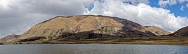
Mount Harper / Mahaanui, as viewed from nearby Lake Camp
135:, of which the mountain is said to be a representation.
234:
226:
218:
177:
167:
159:
139:
121:
116:
77:
67:
57:
52:
30:
445:"Visualizing Māori Land – Mount Harper/Mahaanui"
196:
8:
269:, New Zealand, within the foothills of the
143:
387:
385:
27:
359:
271:Southern Alps / Kā Tiritiri o te Moana
521:"Ngāi Tahu Claims and Settlement Act"
368:"Place name detail: 21 November 2021"
7:
337:Ngāi Tahu Claims Settlement Act 1998
558:Mountains of the Canterbury Region
451:. Manaaki Whenua Landcare Research
14:
527:. Parliamentary Counsel's Office
449:whenuaviz.landcareresearch.co.nz
195:
188:
163:The resting place of Māui's Waka
41:
471:"Mount Harper/Mahaanui hunting"
425:. Land Information New Zealand
1:
376:New Zealand Geographic Board
172:New Zealand Geographic Board
73:1,129 m (3,704 ft)
63:1,829 m (6,001 ft)
281:ranges to the south by the
579:
18:
182:
40:
35:
399:. Te Rūnanga o Ngāi Tahu
397:Cultural Mapping Project
249:Mount Harper / Mahaanui
209:Location in New Zealand
203:Mount Harper / Mahaanui
31:Mount Harper / Mahaanui
16:Mountain in New Zealand
256:
144:
372:New Zealand Gazetteer
327:'. This relates to a
262:Te Nohoaka-o-Mahaanui
145:Te Nohoaka-o-Mahaanui
101:43.6601°S 171.0624°E
525:legislation.govt.nz
500:Wilderness Magazine
419:"Topographical Map"
265:) is a mountain in
160:English translation
97: /
563:Ashburton District
341:Treaty of Waitangi
168:Defining authority
106:-43.6601; 171.0624
53:Highest point
246:
245:
570:
537:
536:
534:
532:
517:
511:
510:
508:
506:
492:
486:
485:
483:
481:
467:
461:
460:
458:
456:
441:
435:
434:
432:
430:
415:
409:
408:
406:
404:
389:
380:
379:
364:
238:
199:
198:
192:
155:
147:
112:
111:
109:
108:
107:
102:
98:
95:
94:
93:
90:
45:
28:
578:
577:
573:
572:
571:
569:
568:
567:
543:
542:
541:
540:
530:
528:
519:
518:
514:
504:
502:
494:
493:
489:
479:
477:
475:www.doc.govt.nz
469:
468:
464:
454:
452:
443:
442:
438:
428:
426:
417:
416:
412:
402:
400:
391:
390:
383:
366:
365:
361:
356:
291:Lake Clearwater
287:Moorhouse Range
285:, and from the
283:Rangitata River
236:
214:
213:
212:
211:
210:
207:
206:
205:
204:
200:
149:
105:
103:
99:
96:
91:
88:
86:
84:
83:
48:
24:
17:
12:
11:
5:
576:
574:
566:
565:
560:
555:
545:
544:
539:
538:
512:
487:
462:
436:
410:
393:"Kā Huru Manu"
381:
358:
357:
355:
352:
244:
243:
240:
232:
231:
228:
224:
223:
220:
216:
215:
208:
202:
201:
194:
193:
187:
186:
185:
184:
183:
180:
179:
175:
174:
169:
165:
164:
161:
157:
156:
141:
137:
136:
127:Named for the
125:
119:
118:
114:
113:
81:
75:
74:
71:
65:
64:
61:
55:
54:
50:
49:
46:
38:
37:
33:
32:
15:
13:
10:
9:
6:
4:
3:
2:
575:
564:
561:
559:
556:
554:
553:Southern Alps
551:
550:
548:
526:
522:
516:
513:
501:
497:
491:
488:
476:
472:
466:
463:
450:
446:
440:
437:
424:
420:
414:
411:
398:
394:
388:
386:
382:
377:
373:
369:
363:
360:
353:
351:
349:
345:
342:
339:, a landmark
338:
334:
330:
326:
321:
319:
315:
311:
307:
303:
299:
294:
292:
288:
284:
280:
276:
272:
268:
264:
263:
259:
254:
250:
241:
239:
233:
229:
225:
221:
217:
191:
181:
176:
173:
170:
166:
162:
158:
153:
146:
142:
138:
134:
130:
126:
124:
120:
115:
110:
82:
80:
76:
72:
70:
66:
62:
60:
56:
51:
44:
39:
34:
29:
26:
22:
529:. Retrieved
524:
515:
503:. Retrieved
499:
490:
478:. Retrieved
474:
465:
453:. Retrieved
448:
439:
427:. Retrieved
422:
413:
401:. Retrieved
396:
371:
362:
329:Māori legend
322:
295:
261:
257:
248:
247:
242:Harper Range
237:Parent range
25:
21:Mount Harper
531:19 November
505:21 November
480:21 November
455:21 November
429:21 November
403:21 November
275:Ben Macleod
222:New Zealand
140:Native name
104: /
92:171°03′45″E
79:Coordinates
547:Categories
354:References
344:settlement
267:Canterbury
230:Canterbury
89:43°39′36″S
69:Prominence
423:NZTopoMap
348:Ngāi Tahu
279:Tara Haoa
178:Geography
123:Etymology
59:Elevation
333:Tarahaoa
318:trampers
302:red deer
258:Mahaanui
36:Mahaanui
306:chamois
298:tussock
219:Country
227:Region
148:
117:Naming
346:with
253:Māori
152:Māori
533:2021
507:2021
482:2021
457:2021
431:2021
405:2021
325:waka
314:pigs
312:and
310:tahr
277:and
133:Māui
129:waka
260:or
131:of
549::
523:.
498:.
473:.
447:.
421:.
395:.
384:^
374:.
370:.
308:,
304:,
293:.
255::
535:.
509:.
484:.
459:.
433:.
407:.
378:.
251:(
154:)
150:(
23:.
Text is available under the Creative Commons Attribution-ShareAlike License. Additional terms may apply.