155:
108:
162:
115:
34:
202:
497:
369:, and approximately 1500 rice terraces remain in use. The area under protection by the government is approximately 40 hectares at an altitude of 460 to 560 meters. The landscape was featured in literature and painting subjects, including some
323:, whereby an infirm or elderly relative who were a burden on the community were taken to a remote, desolate place, and left there to die. The identification of Mount Kamuriki as this location appears to be from legends in the
292:
eroded lava dome, and although no direct evidence of volcanic activity exists, columnar joints can be observed on the rock on the eastern slope of the summit. A large portion of the summit collapsed during the
154:
265:
388:
107:
544:
63:
549:
419:
56:
472:
454:
365:
in the year 2010. The Tagoto-no-tsuki rice terraces were developed during the mid-16th century in the middle of the
534:
393:
362:
508:
501:
539:
337:
294:
358:
468:
325:
316:
236:
232:
135:
131:
311:
331:
228:
127:
33:
288:
strata were deposited during the time the area was ocean floor. The summit is a bipyrite
240:
188:
201:
528:
516:
354:
315:
poetry anthology of 905 AD, indicating that the legend itself was much older. Per
450:
345:), which resembles a person carrying another person on his back up the mountain.
281:
280:
intrusion into the central uplift zone and western sedimentary zone of northern
366:
277:
227:
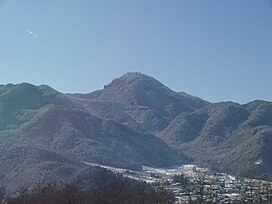
is a 1,252 m (4,108 ft) mountain peak on the border of the city of
78:
65:
496:
440:
Japan, An
Illustrated Encyclopedia, Kodansha Ltd., Tokyo, 1993, on p. 1121
376:
320:
289:
285:
398:
306:
264:
after an old legend. the mountain is located within the borders of the
46:
371:
244:
200:
139:
341:, (c.1120 AD) among others. The mountain has a landform (the
284:
where the sandstone, conglomerate and tuff deposits of the
276:
Mount
Kamuriki is southwest of the Nagano Basin and is a
469:"Database of Registered National Cultural Properties"
357:
at its foothills were designated one of the
National
187:
94:
55:
45:
40:
21:
389:List of Places of Scenic Beauty of Japan (Nagano)
220:
257:
214:
305:The mountain is strongly associated with the
266:Yatsugatake-Chūshin Kōgen Quasi-National Park
8:
18:
418:Hoffman, Michael (September 12, 2010).
410:
161:
114:
363:Important Cultural Landscape of Japan
353:The mountain and the Tagoto-no-tsuki
7:
319:, the pre-modern Japanese practiced
14:
495:
379:, especially in the Edo period.
359:Places of Scenic Beauty of Japan
160:
153:
113:
106:
32:
545:Mountains of Nagano Prefecture
1:
349:Tagoto-no-tsuki rice terraces
144:Show map of Nagano Prefecture
309:, which is mentioned in the
51:1,252 m (4,108 ft)
473:Agency for Cultural Affairs
455:Agency for Cultural Affairs
221:
566:
394:Cultural Landscape (Japan)
509:Shinshu tourism home page
258:
215:
99:
31:
26:
420:"Aging through the ages"
550:Places of Scenic Beauty
517:Chikuma city home page
295:1847 Nagano earthquake
206:
174:Mount Kamuriki (Japan)
79:36.46861°N 138.10667°E
16:Mountain peak in Japan
504:at Wikimedia Commons
361:in 1990. and also an
338:Konjaku Monogatarishū
204:
247:. It is also called
335:(1059 AD), and the
231:and the village of
84:36.46861; 138.10667
75: /
307:Ubasuteyama legend
301:Ubasuteyama legend
207:
41:Highest point
535:Chikuhoku, Nagano
500:Media related to
422:. The Japan Times
326:Yamato Monogatari
317:Japanese folklore
237:Nagano Prefecture
199:
198:
195:Chikuma Mountains
177:Show map of Japan
136:Nagano Prefecture
557:
521:
513:
499:
484:
483:
481:
479:
465:
459:
458:
447:
441:
438:
432:
431:
429:
427:
415:
263:
261:
260:
226:
224:
218:
217:
191:
178:
164:
163:
157:
145:
117:
116:
110:
90:
89:
87:
86:
85:
80:
76:
73:
72:
71:
68:
36:
19:
565:
564:
560:
559:
558:
556:
555:
554:
540:Chikuma, Nagano
525:
524:
519:
511:
493:
488:
487:
477:
475:
467:
466:
462:
453:(in Japanese).
449:
448:
444:
439:
435:
425:
423:
417:
416:
412:
407:
385:
351:
332:Sarashina Nikki
303:
274:
255:
212:
189:
183:
182:
181:
180:
179:
176:
175:
172:
171:
170:
169:
165:
148:
147:
146:
143:
142:
138:
125:
124:
123:
122:
118:
83:
81:
77:
74:
69:
66:
64:
62:
61:
17:
12:
11:
5:
563:
561:
553:
552:
547:
542:
537:
527:
526:
523:
522:
514:
502:Mount Kamuriki
492:
491:External links
489:
486:
485:
460:
442:
433:
409:
408:
406:
403:
402:
401:
396:
391:
384:
381:
350:
347:
329:(951 AD), the
302:
299:
273:
270:
210:Mount Kamurigi
197:
196:
193:
185:
184:
173:
168:Mount Kamuriki
167:
166:
159:
158:
152:
151:
150:
149:
126:
121:Mount Kamuriki
120:
119:
112:
111:
105:
104:
103:
102:
101:
100:
97:
96:
92:
91:
59:
53:
52:
49:
43:
42:
38:
37:
29:
28:
24:
23:
22:Mount Kamuriki
15:
13:
10:
9:
6:
4:
3:
2:
562:
551:
548:
546:
543:
541:
538:
536:
533:
532:
530:
520:(in Japanese)
518:
515:
512:(in Japanese)
510:
507:
506:
505:
503:
498:
490:
474:
470:
464:
461:
456:
452:
446:
443:
437:
434:
421:
414:
411:
404:
400:
397:
395:
392:
390:
387:
386:
382:
380:
378:
374:
373:
368:
364:
360:
356:
355:rice terraces
348:
346:
344:
340:
339:
334:
333:
328:
327:
322:
318:
314:
313:
312:Kokin Wakashū
308:
300:
298:
296:
291:
287:
283:
279:
271:
269:
267:
254:
250:
246:
242:
238:
234:
230:
223:
211:
203:
194:
192:
186:
156:
141:
137:
133:
129:
109:
98:
93:
88:
60:
58:
54:
50:
48:
44:
39:
35:
30:
25:
20:
494:
476:. Retrieved
463:
445:
436:
424:. Retrieved
413:
370:
352:
343:Bokodaki Iwa
342:
336:
330:
324:
310:
304:
275:
252:
248:
241:Chūbu region
222:Kamuriki-san
209:
208:
205:Bokodaki Iwa
190:Parent range
282:Fossa Magna
253:Obasuteyama
249:Ubasuteyama
82: /
70:138°06′24″E
57:Coordinates
529:Categories
451:"姨捨(田毎の月)"
405:References
367:Edo period
278:Quaternary
67:36°28′07″N
426:19 August
272:Geography
233:Chikuhoku
132:Chikuhoku
95:Geography
47:Elevation
478:29 April
383:See also
321:senicide
290:andesite
286:Tertiary
399:Ubasute
239:in the
229:Chikuma
128:Chikuma
377:Basho
372:haiku
245:Japan
140:Japan
480:2011
428:2016
130:and
375:by
259:姨捨山
251:or
243:of
235:in
216:冠着山
27:冠着山
531::
471:.
297:.
268:.
219:,
134:,
482:.
457:.
430:.
262:)
256:(
225:)
213:(
Text is available under the Creative Commons Attribution-ShareAlike License. Additional terms may apply.