484:
472:
208:
175:
201:
520:
168:
500:
29:
483:
471:
367:
is significant as the south aspect rises nearly 2,000 feet (610 meters) above the surrounding terrain in approximately one mile. The approach to this remote peak is made via the
108:
443:, and travel east toward the Sierra Nevada mountains. As fronts approach, they are forced upward by the peaks, causing them to drop their moisture in the form of rain or
727:
722:
411:. He died of sudden heart failure at age 39 while on a field trip for the Forest Service attending a football game between University of California and
737:
634:
200:
416:
742:
732:
533:
625:
167:
707:
412:
428:
630:
271:
392:
101:
676:
Peel, M. C.; Finlayson, B. L.; McMahon, T. A. (2007). "Updated world map of the Köppen−Geiger climate classification".
664:
653:
499:
360:
348:
237:
72:
340:
241:
404:
620:
396:
320:
456:
67:
57:
388:
352:
79:
94:
363:, which is the nearest higher neighbor. Mt. Wynne ranks as the 116th highest summit in California.
364:
286:
89:
685:
28:
525:
448:
408:
368:
266:
452:
432:
400:
252:
331:
is a 13,179-foot-elevation (4,017-meter) mountain summit located one mile west of the
716:
440:
436:
336:
259:
372:
356:
332:
313:
303:
34:
490:
376:
291:
560:
515:
344:
245:
689:
123:
110:
145:
444:
589:
47:
415:. The mountain's toponym was officially adopted in 1932 by the
477:
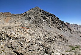
Mount Wynne viewed from the south along the John Muir Trail.
654:
Fred L. Jones, A Climber’s Guide to the High Sierra (1954)
399:, who died through his official work. He was born in
312:
302:
297:
285:
280:
265:
251:
233:
154:
144:
139:
100:
88:
78:
66:
56:
46:
41:
21:
665:Yale Forest School News, Volume XI, 1923, page 8.
455:from the mountain drains into tributaries of the
351:, 31 miles (50 km) northwest of the town of
584:
582:
580:
8:
347:, United States. It is situated in eastern
16:Mountain in Fresno County, California, U.S.
18:
359:, and 0.66 miles (1.06 km) south of
635:United States Department of the Interior
728:Mountains of Kings Canyon National Park
545:
467:
417:United States Board on Geographic Names
723:Mountains of Fresno County, California
615:
613:
611:
609:
431:system, Mount Wynne is located in an
7:
555:
553:
551:
549:
534:List of mountain peaks of California
375:of the summit was made in 1935 by a
626:Geographic Names Information System
207:
174:
14:
413:University of Southern California
738:Mountains of Northern California
518:
498:
482:
470:
355:, 0.4 miles immediately east of
206:
199:
173:
166:
27:
631:United States Geological Survey
220:Mount Wynne (the United States)
1:
743:Sierra Nevada (United States)
733:North American 4000 m summits
429:Köppen climate classification
223:Show map of the United States
52:13,179 ft (4,017 m)
590:"Wynne, Mount - 13,179' CA"
84:0.66 mi (1.06 km)
759:
349:Kings Canyon National Park
238:Kings Canyon National Park
124:36.9380113°N 118.4029183°W
561:"Mount Wynne, California"
159:
26:
405:University of California
129:36.9380113; -118.4029183
678:Hydrol. Earth Syst. Sci
397:Sequoia National Forest
387:The peak's name honors
62:318 ft (97 m)
457:South Fork Kings River
190:Show map of California
187:Location in California
95:Sierra Peaks Section
389:Sedman Walter Wynne
339:mountain range, in
120: /
706:Weather forecast:
395:supervisor of the
365:Topographic relief
42:Highest point
451:). Precipitation
439:originate in the
427:According to the
393:US Forest Service
326:
325:
33:West aspect from
750:
694:
693:
673:
667:
662:
656:
651:
645:
644:
642:
641:
617:
604:
603:
601:
600:
586:
575:
574:
572:
571:
557:
528:
526:Mountains portal
523:
522:
521:
502:
486:
474:
447:onto the range (
316:
255:
246:California, U.S.
224:
210:
209:
203:
191:
177:
176:
170:
135:
134:
132:
131:
130:
125:
121:
118:
117:
116:
113:
31:
19:
758:
757:
753:
752:
751:
749:
748:
747:
713:
712:
703:
698:
697:
675:
674:
670:
663:
659:
652:
648:
639:
637:
619:
618:
607:
598:
596:
594:listsofjohn.com
588:
587:
578:
569:
567:
559:
558:
547:
542:
524:
519:
517:
514:
509:
506:
503:
494:
487:
478:
475:
465:
449:orographic lift
425:
385:
369:John Muir Trail
314:
253:
244:
240:
229:
228:
227:
226:
225:
222:
221:
218:
217:
216:
215:
211:
194:
193:
192:
189:
188:
185:
184:
183:
182:
178:
150:Sedman W. Wynne
128:
126:
122:
119:
114:
111:
109:
107:
106:
37:
17:
12:
11:
5:
756:
754:
746:
745:
740:
735:
730:
725:
715:
714:
711:
710:
702:
701:External links
699:
696:
695:
668:
657:
646:
605:
576:
565:Peakbagger.com
544:
543:
541:
538:
537:
536:
530:
529:
513:
510:
508:
507:
504:
497:
495:
488:
481:
479:
476:
469:
466:
464:
461:
437:weather fronts
433:alpine climate
424:
421:
401:Butte, Montana
384:
381:
324:
323:
318:
310:
309:
306:
300:
299:
295:
294:
289:
283:
282:
278:
277:
269:
263:
262:
257:
249:
248:
235:
231:
230:
219:
213:
212:
205:
204:
198:
197:
196:
195:
186:
180:
179:
172:
171:
165:
164:
163:
162:
161:
160:
157:
156:
152:
151:
148:
142:
141:
137:
136:
104:
98:
97:
92:
86:
85:
82:
76:
75:
70:
64:
63:
60:
54:
53:
50:
44:
43:
39:
38:
32:
24:
23:
15:
13:
10:
9:
6:
4:
3:
2:
755:
744:
741:
739:
736:
734:
731:
729:
726:
724:
721:
720:
718:
709:
705:
704:
700:
691:
687:
683:
679:
672:
669:
666:
661:
658:
655:
650:
647:
636:
632:
628:
627:
622:
621:"Mount Wynne"
616:
614:
612:
610:
606:
595:
591:
585:
583:
581:
577:
566:
562:
556:
554:
552:
550:
546:
539:
535:
532:
531:
527:
516:
511:
501:
496:
492:
489:Mt. Wynne by
485:
480:
473:
468:
462:
460:
458:
454:
450:
446:
442:
441:Pacific Ocean
438:
434:
430:
422:
420:
418:
414:
410:
406:
402:
398:
394:
391:(1883–1922),
390:
382:
380:
378:
374:
370:
366:
362:
361:Mount Pinchot
358:
354:
350:
346:
342:
341:Fresno County
338:
337:Sierra Nevada
334:
330:
322:
319:
317:
315:Easiest route
311:
307:
305:
301:
296:
293:
290:
288:
284:
279:
276:
275:Mount Pinchot
273:
270:
268:
264:
261:
260:Sierra Nevada
258:
256:
250:
247:
243:
242:Fresno County
239:
236:
232:
202:
169:
158:
153:
149:
147:
143:
138:
133:
105:
103:
99:
96:
93:
91:
87:
83:
81:
77:
74:
73:Mount Pinchot
71:
69:
65:
61:
59:
55:
51:
49:
45:
40:
36:
30:
25:
20:
681:
677:
671:
660:
649:
638:. Retrieved
624:
597:. Retrieved
593:
568:. Retrieved
564:
505:South aspect
426:
386:
373:first ascent
357:Pinchot Pass
343:of northern
328:
327:
321:class 2
304:First ascent
287:Type of rock
274:
254:Parent range
35:Pinchot Pass
708:Mount Wynne
491:Ansel Adams
435:zone. Most
403:, attended
377:Sierra Club
329:Mount Wynne
292:metamorphic
214:Mount Wynne
181:Mount Wynne
127: /
115:118°24′11″W
102:Coordinates
68:Parent peak
22:Mount Wynne
717:Categories
640:2021-04-15
599:2021-04-15
570:2021-04-14
540:References
345:California
112:36°56′17″N
58:Prominence
690:1027-5606
383:Etymology
353:Lone Pine
155:Geography
146:Etymology
80:Isolation
48:Elevation
512:See also
493:ca. 1936
445:snowfall
298:Climbing
267:Topo map
234:Location
463:Gallery
423:Climate
379:party.
335:of the
281:Geology
90:Listing
688:
453:runoff
407:, and
371:. The
140:Naming
333:crest
686:ISSN
409:Yale
308:1935
272:USGS
719::
684:.
682:11
680:.
633:,
629:.
623:.
608:^
592:.
579:^
563:.
548:^
459:.
419:.
692:.
643:.
602:.
573:.
Text is available under the Creative Commons Attribution-ShareAlike License. Additional terms may apply.