68:
40:
200:). The annual average temperature in the area is 26 °C. The warmest month is October, when the average temperature is around 30 °C, and the coldest is February, at 24 °C. The average annual rainfall is 1456 mm.. The wettest month is January, with an average of 294 mm rainfall, and the driest is August, with 19 mm rainfall.
75:
47:
383:
219:
447:
209:
67:
452:
197:
376:
39:
423:
214:
442:
369:
392:
332:
189:
319:
265:
277:
173:
156:
407:
285:
281:
436:
251:
305:
141:
290:
347:
334:
188:
The river flows along the northwestern area of
Sumbawa with predominantly
396:
177:
169:
130:
361:
254:
at
Geonames.org (cc-by); Database dump downloaded 27 November 2015
365:
266:"Updated world map of the Köppen-Geiger climate classification"
322:. NASA/Tropical Rainfall Monitoring Mission. 30 January 2016.
176:
province, Indonesia, about 1200 km east of capital
27:
Brang Moyo, Sungai Brang Moyo, Brang Mojo, Mojo River
320:"NASA Earth Observations: Rainfall (1 month – TRMM)"
150:
140:
124:
116:
107:
99:
94:
23:
264:Peel, M C; Finlayson, B L; McMahon, T A (2007).
377:
8:
384:
370:
362:
289:
306:"NASA Earth Observations Data Set Index"
231:
220:List of rivers of Lesser Sunda Islands
20:
7:
210:List of drainage basins of Indonesia
198:Köppen-Geiger climate classification
270:Hydrology and Earth System Sciences
74:
46:
14:
73:
66:
45:
38:
1:
108:Physical characteristics
448:Rivers of West Nusa Tenggara
240:The New International Atlas
215:List of rivers of Indonesia
152: • location
126: • location
469:
453:Drainage basins of Sumbawa
421:
403:
291:10.5194/hess-11-1633-2007
136:
112:
32:
308:. NASA. 30 January 2016.
190:tropical savanna climate
82:Moyo River (Indonesia)
85:Show map of Indonesia
54:Location of the mouth
424:Rivers of Indonesia
348:8.4621°S 117.4789°E
344: /
282:2007HESS...11.1633P
57:Show map of Sumbawa
174:West Nusa Tenggara
157:West Nusa Tenggara
16:River in Indonesia
443:Rivers of Sumbawa
430:
429:
353:-8.4621; 117.4789
162:
161:
460:
386:
379:
372:
363:
359:
358:
356:
355:
354:
349:
345:
342:
341:
340:
337:
324:
323:
316:
310:
309:
302:
296:
295:
293:
276:(5): 1633–1644.
261:
255:
249:
243:
236:
127:
86:
77:
76:
70:
58:
49:
48:
42:
21:
468:
467:
463:
462:
461:
459:
458:
457:
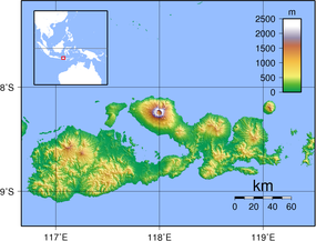
433:
432:
431:
426:
417:
399:
390:
352:
350:
346:
343:
338:
335:
333:
331:
330:
328:
327:
318:
317:
313:
304:
303:
299:
263:
262:
258:
250:
246:
237:
233:
228:
206:
192:(designated as
186:
153:
125:
90:
89:
88:
87:
84:
83:
80:
79:
78:
61:
60:
59:
56:
55:
52:
51:
50:
28:
25:
17:
12:
11:
5:
466:
464:
456:
455:
450:
445:
435:
434:
428:
427:
422:
419:
418:
416:
415:
410:
404:
401:
400:
391:
389:
388:
381:
374:
366:
326:
325:
311:
297:
256:
244:
238:Rand McNally,
230:
229:
227:
224:
223:
222:
217:
212:
205:
202:
185:
182:
168:is a river of
160:
159:
154:
151:
148:
147:
144:
138:
137:
134:
133:
128:
122:
121:
118:
114:
113:
110:
109:
105:
104:
101:
97:
96:
92:
91:
81:
72:
71:
65:
64:
63:
62:
53:
44:
43:
37:
36:
35:
34:
33:
30:
29:
26:
15:
13:
10:
9:
6:
4:
3:
2:
465:
454:
451:
449:
446:
444:
441:
440:
438:
425:
420:
414:
411:
409:
406:
405:
402:
398:
394:
387:
382:
380:
375:
373:
368:
367:
364:
360:
357:
321:
315:
312:
307:
301:
298:
292:
287:
283:
279:
275:
271:
267:
260:
257:
253:
248:
245:
241:
235:
232:
225:
221:
218:
216:
213:
211:
208:
207:
203:
201:
199:
195:
191:
183:
181:
179:
175:
171:
167:
158:
155:
149:
145:
143:
139:
135:
132:
129:
123:
119:
115:
111:
106:
102:
98:
93:
69:
41:
31:
22:
19:
412:
329:
314:
300:
273:
269:
259:
247:
239:
234:
193:
187:
165:
163:
18:
351: /
339:117°28′44″E
437:Categories
408:Brang Biji
252:Brang Moyo
226:References
166:Moyo River
24:Moyo River
336:8°27′44″S
184:Geography
103:Indonesia
204:See also
95:Location
397:Sumbawa
278:Bibcode
242:, 1993.
196:in the
178:Jakarta
170:Sumbawa
131:Sumbawa
100:Country
393:Rivers
146:
120:
117:Source
142:Mouth
413:Moyo
164:The
395:of
286:doi
439::
284:.
274:11
272:.
268:.
194:As
180:.
172:,
385:e
378:t
371:v
294:.
288::
280::
Text is available under the Creative Commons Attribution-ShareAlike License. Additional terms may apply.