326:(High Ridge Road). Immediately after crossing the state line, NY 137 passes east of the Pound Ridge Golf Club, which runs along the state line. NY 137 proceeds north through Pound Ridge as High Ridge Road, intersecting with Old Snake Hill Road, which runs along Snake Hill and re-intersects a short distance later. After descending from Snake Hill, NY 137 enters the hamlet of Sarles Corners, where it intersects with Upper Shad Road. After leaving Sarles Corners, NY 137 bends northward, becoming a two-lane residential street through Pound Ridge, running along the side of Horseshoe Hill, where it intersects with Westchester Avenue. At this junction, NY 137 drops the High Ridge Road moniker, and gains the Westchester Avenue moniker.
622:
580:
95:
426:
303:
764:
37:
690:
616:
574:
338:(Salem Road). At this junction, NY 137 bends north, intersects with a connector road to NY 124 then turns northwest on Stone Hill Road. Stone Hill Road is a two-lane wooded street, and NY 137 proceeds northwest through the town of Pound Ridge past a pond. A short distance later, residences appear along the highway as it climbs westward along Stone Hill.
653:
610:
727:
696:
659:
239:
224:
114:
410:
as part of a highway maintenance swap between the two levels of government. NY 137 was truncated to the southern terminus of its overlap with NY 121 as a result. The former routing of NY 137 along Girdle Ridge and Pea Pond roads was redesignated as County Route 309. An expressway
370:
to
Westchester Avenue in the area of Horseshoe Hill along with the alignment of former NY 137A was upgraded to state standards in the early 1900s. The segment, designated as unsigned State Highway 1306 (SH 1306), 5.72 miles (9.21 km), was given a contract on August 31, 1915.
329:
After the junction, NY 137 continues northward through the town of Pound Ridge, soon entering the hamlet with the same name. The hamlet consists of several residences, commercial businesses and most importantly, a junction with the eastern terminus of
341:
After descending from Stone Hill, NY 137 bends southwest passing several ponds and the Stone Hill River as it works its way west once again. Passing several residences, NY 137 begins winding west into the town of
1295:
777:
371:
The highway took over six years to complete, with construction being completed on
November 23, 1921, at the cost of $ 111,453.53 (1921 USD) with $ 72,446.09 paid by the
833:, 1930–31 and 1931–32 editions, (Scarborough Motor Guide Co., Boston, 1930 and 1931). The 1930–31 edition shows New York state routes prior to the
1265:
1212:
1290:
806:
62:
488:
379:
799:
187:
402:
with NY 121. On
September 1, 1980, ownership and maintenance of Girdle Ridge and Pea Pond roads was transferred from the state of
202:
334:(Pound Ridge Road). After bending northeast out of downtown, NY 137 passes the Hiram Halle Memorial Library and into a junction with
346:. Through Bedford, NY 137 retains the Stone Hill Road moniker, crosses over Stone Hill River as it descends towards the hamlet of
929:
197:
192:
179:
530:
407:
267:
160:
834:
943:
1146:
1124:
1103:
997:
730:
714:
700:
663:
637:
631:
514:
367:
363:
351:
343:
335:
331:
287:
242:
227:
121:
117:
734:
667:
588:
391:
387:
347:
291:
738:
704:
627:
584:
560:
484:
476:
445:
383:
323:
319:
283:
279:
275:
102:
98:
1042:
1015:
1172:
207:
1099:
890:
Tables Giving
Detailed Information and Present Status of All State, County and Federal Aid Highways
947:
1256:
1128:
1001:
769:
673:
518:
888:
1168:
972:
925:
894:
510:
403:
372:
311:
150:
1150:
991:
521:
of Pound Ridge by 1970. Westchester Avenue is now maintained by the town of Pound Ridge.
506:
399:
50:
Map of
Westchester County in southeastern New York with NY 137 highlighted in red
1284:
263:
140:
354:(Old Post Road). This intersection serves as the northern terminus of NY 137.
1216:
1186:
594:
480:
449:
395:
315:
302:
271:
759:
472:
864:
851:
425:
1275:
517:. The extension was short-lived as NY 124 was truncated back to the
1067:
411:
was planned along the NY–CT Route 137 corridor in the 1950s.
17:
1264:
1047:(Map). 1:24,000. New York State Department of Transportation. 1990
1020:(Map). 1:24,000. New York State Department of Transportation. 1990
976:
855:
301:
36:
487:), by way of Westchester Avenue. It was assigned as part of the
483:
state line, where it connected to State
Highway 184 (later
748:
1.000 mi = 1.609 km; 1.000 km = 0.621 mi
398:
line by way of Girdle Ridge and Pea Pond roads and a short
859:
1218:
Official
Description of Touring Routes in New York State
831:
Automobile Legal
Association (ALA) Automobile Green Book
1252:
1247:
709:
Southern terminus of NY 124; hamlet of Pound Ridge
270:, in the United States. The route is a continuation of
778:
1037:
1035:
455:
441:
421:
170:
156:
146:
136:
131:
108:
89:
84:
76:
68:
55:
32:
887:State of New York Commission of Highways (1922).
382:as a continuation of the road leading north from
27:State highway in Westchester County, New York, US
1068:"Unbuilt Pound Ridge–Stamford Expressway"
1296:Transportation in Westchester County, New York
1266:Template:Attached KML/New York State Route 137
1213:State of New York Department of Transportation
513:. In 1967, NY 394 became an extension of
498:, which in turn was renumbered to NY 394
489:1930 renumbering of state highways in New York
380:1930 renumbering of state highways in New York
800:"2008 Traffic Data Report for New York State"
491:. NY 137A was renumbered to NY 104
8:
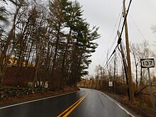
306:NY 137 east from NY 121 in Bedford
807:New York State Department of Transportation
1143:Road Map & Historical Guide – New York
1115:
1113:
1090:
1088:
535:
362:The roadway that make up NY 137 from
216:
1269:
971:(Map) (1977–78 ed.). Cartography by
916:
914:
912:
794:
792:
282:. NY 137 goes through the hamlet of
1187:"Connecticut Routes 120–124 – Route 124"
505:to eliminate numerical duplication with
378:NY 137 was first designated in the
788:
846:
844:
842:
636:Access via Westchester Avenue; former
418:
29:
1044:Pound Ridge Digital Raster Quadrangle
1017:Mount Kisco Digital Raster Quadrangle
724:
718:
686:
680:
649:
643:
606:
600:
570:
564:
262:) is a 5.51-mile (8.87 km) long
7:
826:
824:
294:, locally known as Bedford Village.
1291:State highways in New York (state)
948:"New York State Highway Law § 341"
547:
479:that connected NY 137 to the
25:
672:Eastern terminus of NY 172;
930:Standard Oil Company of New York
897:: J. B. Lyon Company. p. 66
762:
725:
694:
688:
657:
651:
620:
614:
608:
578:
572:
424:
237:
222:
112:
93:
72:5.51 mi (8.87 km)
35:
322:as a northern continuation of
386:. The original route ran from
1:
542:
499:
492:
460:
278:, which links NY 137 to
256:New York State Route 137
1274:New York State Route 137 at
809:. June 16, 2009. p. 248
268:Westchester County, New York
350:, where it intersects with
1312:
1121:Texaco Road Map – New York
944:New York State Legislature
318:state line in the town of
310:NY 137 begins at the
747:
742:
721:
713:
708:
683:
671:
646:
635:
603:
592:
567:
559:
554:
551:
546:
541:
538:
437:
431:New York State Route 137A
215:
175:
166:
127:
60:
48:
1147:Rand McNally and Company
1125:Rand McNally and Company
1104:Kendall Refining Company
998:Rand McNally and Company
860:"overview map of NY 137"
42:New York State Route 137
529:The entire route is in
1167:(Map). Cartography by
1145:(Map). Cartography by
1123:(Map). Cartography by
1098:(Map). Cartography by
996:(Map). Cartography by
924:(Map). Cartography by
450:Connecticut state line
307:
384:Stamford, Connecticut
305:
280:Stamford, Connecticut
1270:KML is from Wikidata
1173:Standard Oil Company
922:Road Map of New York
1215:(January 1, 1970).
1100:H.M. Gousha Company
525:Major intersections
507:U.S. Route 104
477:town of Pound Ridge
471:NY 137A was a
368:the town of Bedford
593:Continuation into
531:Westchester County
408:Westchester County
308:
1129:Texas Oil Company
1066:Anderson, Steve.
1002:State of New York
770:U.S. roads portal
753:
752:
743:Northern terminus
469:
468:
392:hamlet of Bedford
373:state of New York
298:Route description
292:hamlet of Bedford
253:
252:
249:
248:
180:New York Highways
56:Route information
16:(Redirected from
1303:
1260:
1233:
1232:
1230:
1228:
1223:
1209:
1203:
1202:
1200:
1198:
1183:
1177:
1176:
1169:General Drafting
1161:
1155:
1154:
1139:
1133:
1132:
1117:
1108:
1107:
1092:
1083:
1082:
1080:
1078:
1063:
1057:
1056:
1054:
1052:
1039:
1030:
1029:
1027:
1025:
1012:
1006:
1005:
987:
981:
980:
973:General Drafting
965:
959:
958:
956:
954:
940:
934:
933:
926:General Drafting
918:
907:
906:
904:
902:
884:
878:
877:
875:
873:
848:
837:
835:1930 renumbering
828:
819:
818:
816:
814:
804:
796:
772:
767:
766:
765:
729:
728:
699:
698:
697:
692:
691:
662:
661:
660:
655:
654:
625:
624:
623:
618:
617:
612:
611:
583:
582:
581:
576:
575:
549:
544:
536:
511:Upstate New York
504:
501:
497:
494:
465:
462:
428:
419:
245:
241:
240:
230:
226:
225:
217:
116:
115:
97:
96:
39:
30:
21:
1311:
1310:
1306:
1305:
1304:
1302:
1301:
1300:
1281:
1280:
1276:New York Routes
1271:
1268:
1263:
1262:
1261:
1245:
1241:
1236:
1226:
1224:
1221:
1211:
1210:
1206:
1196:
1194:
1193:. July 27, 2007
1185:
1184:
1180:
1163:
1162:
1158:
1151:Sun Oil Company
1141:
1140:
1136:
1119:
1118:
1111:
1094:
1093:
1086:
1076:
1074:
1065:
1064:
1060:
1050:
1048:
1041:
1040:
1033:
1023:
1021:
1014:
1013:
1009:
992:I Love New York
989:
988:
984:
967:
966:
962:
952:
950:
942:
941:
937:
920:
919:
910:
900:
898:
886:
885:
881:
871:
869:
850:
849:
840:
829:
822:
812:
810:
802:
798:
797:
790:
786:
768:
763:
761:
758:
749:
726:
715:Town of Bedford
695:
693:
689:
687:
658:
656:
652:
650:
621:
619:
615:
613:
609:
607:
579:
577:
573:
571:
527:
502:
495:
463:
433:
432:
429:
417:
360:
300:
238:
236:
223:
221:
113:
94:
85:Major junctions
51:
44:
43:
40:
28:
23:
22:
15:
12:
11:
5:
1309:
1307:
1299:
1298:
1293:
1283:
1282:
1279:
1278:
1244:
1243:
1242:
1240:
1239:External links
1237:
1235:
1234:
1204:
1178:
1156:
1134:
1109:
1084:
1058:
1031:
1007:
982:
960:
935:
908:
879:
838:
820:
787:
785:
782:
781:
780:
774:
773:
757:
754:
751:
750:
745:
744:
741:
723:
720:
717:
711:
710:
707:
685:
682:
678:
677:
676:of Pound Ridge
670:
648:
645:
641:
640:
634:
632:Scotts Corners
628:Route 124
605:
602:
598:
597:
591:
585:Route 137
569:
566:
563:
557:
556:
553:
550:
545:
540:
526:
523:
485:Route 124
467:
466:
457:
453:
452:
443:
439:
438:
435:
434:
430:
423:
422:
416:
413:
359:
356:
299:
296:
276:Route 137
251:
250:
247:
246:
233:
231:
213:
212:
211:
210:
205:
200:
195:
190:
184:
183:
173:
172:
171:Highway system
168:
167:
164:
163:
158:
154:
153:
148:
144:
143:
138:
134:
133:
129:
128:
125:
124:
110:
109:North end
106:
105:
99:Route 137
91:
90:South end
87:
86:
82:
81:
78:
74:
73:
70:
66:
65:
61:Maintained by
58:
57:
53:
52:
49:
46:
45:
41:
34:
33:
26:
24:
14:
13:
10:
9:
6:
4:
3:
2:
1308:
1297:
1294:
1292:
1289:
1288:
1286:
1277:
1273:
1272:
1267:
1258:
1254:
1250:
1249:
1238:
1220:
1219:
1214:
1208:
1205:
1192:
1188:
1182:
1179:
1174:
1170:
1166:
1160:
1157:
1152:
1148:
1144:
1138:
1135:
1130:
1126:
1122:
1116:
1114:
1110:
1105:
1101:
1097:
1091:
1089:
1085:
1073:
1069:
1062:
1059:
1046:
1045:
1038:
1036:
1032:
1019:
1018:
1011:
1008:
1003:
999:
995:
993:
986:
983:
978:
974:
970:
964:
961:
949:
945:
939:
936:
931:
927:
923:
917:
915:
913:
909:
896:
892:
891:
883:
880:
867:
866:
861:
857:
853:
847:
845:
843:
839:
836:
832:
827:
825:
821:
808:
801:
795:
793:
789:
783:
779:
776:
775:
771:
760:
755:
746:
740:
736:
732:
716:
712:
706:
703:north –
702:
679:
675:
669:
665:
642:
639:
633:
630:south –
629:
599:
596:
590:
587:south –
586:
562:
558:
537:
534:
532:
524:
522:
520:
516:
512:
508:
490:
486:
482:
478:
474:
458:
454:
451:
447:
444:
440:
436:
427:
420:
414:
412:
409:
405:
401:
397:
393:
390:north of the
389:
385:
381:
376:
374:
369:
365:
357:
355:
353:
349:
345:
339:
337:
333:
327:
325:
321:
317:
313:
304:
297:
295:
293:
290:north of the
289:
285:
281:
277:
273:
269:
265:
264:state highway
261:
257:
244:
234:
232:
229:
219:
218:
214:
209:
206:
204:
201:
199:
196:
194:
191:
189:
186:
185:
182:
181:
177:
176:
174:
169:
165:
162:
159:
155:
152:
149:
145:
142:
141:United States
139:
135:
130:
126:
123:
119:
111:
107:
104:
100:
92:
88:
83:
79:
75:
71:
67:
64:
59:
54:
47:
38:
31:
19:
1246:
1225:. Retrieved
1217:
1207:
1195:. Retrieved
1190:
1181:
1164:
1159:
1142:
1137:
1120:
1095:
1075:. Retrieved
1071:
1061:
1049:. Retrieved
1043:
1022:. Retrieved
1016:
1010:
990:
985:
968:
963:
951:. Retrieved
938:
921:
899:. Retrieved
889:
882:
870:. Retrieved
863:
830:
811:. Retrieved
666:west –
552:Destinations
528:
470:
377:
361:
340:
328:
309:
286:and ends at
259:
255:
254:
178:
103:Stamford, CT
80:1930–present
1077:January 26,
1024:January 26,
994:Tourism Map
953:January 26,
868:. Microsoft
813:January 26,
739:Cross River
731:NY 121
705:South Salem
701:NY 124
664:NY 172
595:Connecticut
561:Pound Ridge
515:NY 124
503: 1935
496: 1932
481:Connecticut
464: 1932
446:Pound Ridge
396:Connecticut
364:NY 121
352:NY 121
336:NY 124
332:NY 172
324:CT 137
320:Pound Ridge
316:Connecticut
288:NY 121
284:Pound Ridge
272:Connecticut
260:NY 137
243:NY 138
228:NY 136
161:Westchester
118:NY 121
1285:Categories
895:Albany, NY
784:References
589:High Ridge
473:spur route
388:NY 22
188:Interstate
901:August 6,
865:Bing Maps
852:Microsoft
203:Reference
1248:KML file
1165:New York
1096:New York
1072:NYCRoads
969:New York
756:See also
733: –
539:Location
442:Location
404:New York
312:New York
208:Parkways
157:Counties
151:New York
132:Location
1227:May 20,
1197:May 20,
1175:. 1936.
1153:. 1935.
1131:. 1932.
1106:. 1931.
1051:May 20,
1004:. 1981.
979:. 1977.
932:. 1930.
872:May 16,
862:(Map).
735:Bedford
668:Bedford
475:in the
456:Existed
448:–
415:NY 137A
400:overlap
394:to the
358:History
348:Bedford
314:–
137:Country
122:Bedford
77:Existed
1191:Kurumi
674:hamlet
638:NY 124
519:hamlet
344:Beford
69:Length
63:NYSDOT
18:NY 137
1222:(PDF)
977:Exxon
856:Nokia
803:(PDF)
555:Notes
459:1930–
198:State
147:State
1257:help
1253:edit
1229:2009
1199:2009
1079:2010
1053:2009
1026:2010
955:2010
903:2013
874:2012
815:2010
722:8.87
719:5.51
684:4.25
681:2.64
647:3.98
644:2.47
604:2.80
601:1.74
568:0.00
565:0.00
626:To
509:in
406:to
366:in
274:'s
266:in
120:in
101:in
1287::
1255:•
1189:.
1171:.
1149:.
1127:.
1112:^
1102:.
1087:^
1070:.
1034:^
1000:.
975:.
946:.
928:.
911:^
893:.
858:.
854:;
841:^
823:^
805:.
791:^
737:,
548:km
543:mi
533:.
500:c.
493:c.
461:c.
375:.
235:→
220:←
193:US
1259:)
1251:(
1231:.
1201:.
1081:.
1055:.
1028:.
957:.
905:.
876:.
817:.
258:(
20:)
Text is available under the Creative Commons Attribution-ShareAlike License. Additional terms may apply.