116:
100:
871:
344:
85:
721:
711:
60:
917:
75:
332:
123:
462:) characterized by warm summers and cool winters with light snowfall. The average annual temperature in Namegata is 14.1 °C. The average annual rainfall is 1410 mm with September as the wettest month. The temperatures are highest on average in August, at around 25.8 °C, and lowest in January, at around 3.4 °C.
637:. The towns of Asō and Tamazukuri were created with the establishment of the modern municipalities system on April 1, 1889. The village of Kitaura was established on April 1, 1955, and elevated to town status on October 1, 1997. The three towns merged to form the city of Namegata on September 2, 2005.
685:
Namegata has 16 public elementary schools and four public middle schools operated by the city government, and two public high schools operated by the
Ibaraki Prefectural Board of Education.
115:
391:
of 144.5 persons per km. The percentage of the population aged over 65 was 35.9%. The total area of the city is 222.48 square kilometres (85.90 sq mi).
1254:
99:
870:
653:
city council of 18 members. Namegata contributes one member to the
Ibaraki Prefectural Assembly. In terms of national politics, the city is part of
147:
1249:
1244:
1225:
860:
658:
1110:
84:
916:
59:
1154:
838:
407:
to the west. It is located about 70 kilometers from central Tokyo and about 40 kilometers from the prefectural capital at
1132:
74:
791:
1190:
888:
455:
724:
714:
191:
179:
925:
343:
1178:
1166:
974:
1084:
853:
1054:
1024:
1019:
964:
898:
654:
438:
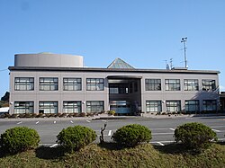
203:
1064:
1059:
258:
804:
1125:
874:
634:
388:
376:
208:
1259:
1183:
1120:
1069:
949:
1212:
1207:
1142:
1115:
1094:
1014:
989:
959:
846:
764:
443:
433:
400:
336:
1089:
1074:
1034:
1009:
979:
758:
470:
Per
Japanese census data, the population of Namegata has declined over the past 40 years.
428:
372:
50:
969:
196:
1200:
1171:
994:
423:
282:
815:
1238:
1159:
1147:
1039:
1029:
906:
883:
770:
662:
646:
626:
408:
270:
1137:
404:
17:
674:
625:, portions of what later became the city of Namegata were under the control of
331:
650:
630:
622:
384:
999:
162:
149:
1079:
249:
984:
954:
1049:
933:
830:
321:
1004:
399:
Namegata is located in south-central
Ibaraki Prefecture, bordered by
254:
380:
342:
330:
293:
184:
1195:
487:
842:
699:
Namegata does not have any commercial passenger rail service.
482:
383:. As of 1 July 2020, the city had an estimated
673:
The economy of
Namegata is primarily agriculture, with
649:
form of government with a directly elected mayor and a
1103:
942:
924:
897:
315:
307:
299:
289:
277:
265:
248:
240:
232:
227:
219:
214:
202:
190:
178:
32:
677:on Lake Kasumigaura taking a predominant role.
362:
356:
38:
854:
311:Aso 1561-9, Namegat-shi, Ibaraki-ken 311-3892
8:
473:
861:
847:
839:
472:
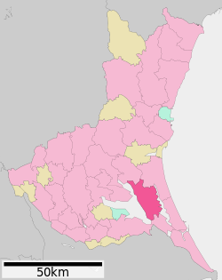
104:Location of Namegata in Ibaraki Prefecture
29:
792:"Ibaraki prefectural official statistics"
735:Namegata has many attractions including:
783:
314:
298:
247:
226:
213:
177:
142:
108:
96:
68:
56:
223:222.48 km (85.90 sq mi)
1226:List of mergers in Ibaraki Prefecture
387:of 32,144 in 11,412 households and a
306:
288:
276:
264:
239:
231:
218:
201:
189:
7:
1255:Populated places established in 2005
25:
915:
869:
719:
709:
122:
121:
114:
98:
83:
73:
58:
816:Namegata population statistics
773:, professional football player
347:Lake Kasumigaura from Namegata
1:
1250:2005 establishments in Japan
1245:Cities in Ibaraki Prefecture
363:
1276:
753:Noted people from Namegata
415:Surrounding municipalities
1223:
913:
881:
500:—
456:Humid continental climate
357:
335:Aerial view of marina on
143:
109:
97:
69:
57:
48:
39:
745:Namegata Farmers Village
163:35.990500°N 140.489028°E
36:
1111:Higashiibaraki District
742:Kasumigaura Fureai Land
725:National Route 355
715:National Route 354
244:140/km (370/sq mi)
348:
340:
805:Namegata climate data
794:(in Japanese). Japan.
474:Historical population
346:
334:
168:35.990500; 140.489028
739:Hitachi Seaside Park
655:Ibaraki 2nd district
241: • Density
27:City in Kantō, Japan
475:
419:Ibaraki Prefecture
259:Japan Standard Time
159: /
875:Ibaraki Prefecture
635:Tokugawa shogunate
389:population density
377:Ibaraki Prefecture
349:
341:
233: • Total
220: • Total
64:Namegata city hall
1232:
1231:
1155:Kitasōma District
1133:Inashiki District
892:
761:, actress, singer
731:Local attractions
614:
613:
329:
328:
300:Phone number
18:Namegata, Ibaraki
16:(Redirected from
1267:
1191:Sashima District
919:
886:
873:
863:
856:
849:
840:
835:
831:Official website
818:
813:
807:
802:
796:
795:
788:
765:Fukushiro Nukaga
748:Sairen-ji Temple
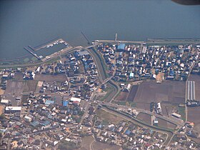
723:
722:
713:
712:
489:
484:
476:
403:to the east and
401:Lake Kasumigaura
370:
369:
366:
360:
359:
337:Lake Kasumigaura
325:
324:
322:Official website
174:
173:
171:
170:
169:
164:
160:
157:
156:
155:
152:
125:
124:
118:
102:
87:
77:
62:
43:
42:
41:
30:
21:
1275:
1274:
1270:
1269:
1268:
1266:
1265:
1264:
1235:
1234:
1233:
1228:
1219:
1099:
938:
920:
911:
893:
877:
867:
833:
827:
822:
821:
814:
810:
803:
799:
790:
789:
785:
780:
759:Hiromi Nagasaku
755:
733:
720:
710:
706:
696:
691:
683:
671:
645:Namegata has a
643:
619:
468:
454:Namegata has a
452:
417:
397:
367:
354:
320:
319:
167:
165:
161:
158:
153:
150:
148:
146:
145:
139:
138:
137:
136:
133:
132:
131:
130:
126:
105:
93:
92:
91:
90:
81:
80:
65:
53:
44:
37:
35:
28:
23:
22:
15:
12:
11:
5:
1273:
1271:
1263:
1262:
1257:
1252:
1247:
1237:
1236:
1230:
1229:
1224:
1221:
1220:
1218:
1217:
1216:
1215:
1205:
1204:
1203:
1198:
1188:
1187:
1186:
1176:
1175:
1174:
1164:
1163:
1162:
1152:
1151:
1150:
1145:
1140:
1130:
1129:
1128:
1123:
1118:
1107:
1105:
1101:
1100:
1098:
1097:
1092:
1087:
1082:
1077:
1072:
1067:
1062:
1057:
1052:
1047:
1042:
1037:
1032:
1027:
1022:
1017:
1012:
1007:
1002:
997:
992:
987:
982:
977:
972:
967:
962:
957:
952:
946:
944:
940:
939:
937:
936:
930:
928:
922:
921:
914:
912:
910:
909:
903:
901:
895:
894:
882:
879:
878:
868:
866:
865:
858:
851:
843:
837:
836:
826:
825:External links
823:
820:
819:
808:
797:
782:
781:
779:
776:
775:
774:
768:
762:
754:
751:
750:
749:
746:
743:
740:
732:
729:
728:
727:
717:
705:
702:
701:
700:
695:
692:
690:
689:Transportation
687:
682:
679:
670:
667:
642:
639:
618:
615:
612:
611:
608:
605:
601:
600:
597:
594:
590:
589:
586:
583:
579:
578:
575:
572:
568:
567:
564:
561:
557:
556:
553:
550:
546:
545:
542:
539:
535:
534:
531:
528:
524:
523:
520:
517:
513:
512:
509:
506:
502:
501:
498:
495:
491:
490:
485:
480:
467:
464:
451:
448:
447:
446:
441:
436:
431:
426:
416:
413:
396:
393:
327:
326:
317:
313:
312:
309:
305:
304:
301:
297:
296:
291:
287:
286:
283:Lilium auratum
279:
275:
274:
267:
263:
262:
252:
246:
245:
242:
238:
237:
234:
230:
229:
225:
224:
221:
217:
216:
212:
211:
206:
200:
199:
194:
188:
187:
182:
176:
175:
141:
140:
134:
128:
127:
120:
119:
113:
112:
111:
110:
107:
106:
103:
95:
94:
88:
82:
78:
72:
71:
70:
67:
66:
63:
55:
54:
49:
46:
45:
33:
26:
24:
14:
13:
10:
9:
6:
4:
3:
2:
1272:
1261:
1258:
1256:
1253:
1251:
1248:
1246:
1243:
1242:
1240:
1227:
1222:
1214:
1211:
1210:
1209:
1208:Yūki District
1206:
1202:
1199:
1197:
1194:
1193:
1192:
1189:
1185:
1182:
1181:
1180:
1179:Naka District
1177:
1173:
1170:
1169:
1168:
1167:Kuji District
1165:
1161:
1158:
1157:
1156:
1153:
1149:
1146:
1144:
1141:
1139:
1136:
1135:
1134:
1131:
1127:
1124:
1122:
1119:
1117:
1114:
1113:
1112:
1109:
1108:
1106:
1102:
1096:
1093:
1091:
1088:
1086:
1083:
1081:
1078:
1076:
1073:
1071:
1068:
1066:
1063:
1061:
1058:
1056:
1053:
1051:
1048:
1046:
1043:
1041:
1038:
1036:
1033:
1031:
1028:
1026:
1023:
1021:
1018:
1016:
1013:
1011:
1008:
1006:
1003:
1001:
998:
996:
993:
991:
988:
986:
983:
981:
978:
976:
973:
971:
968:
966:
963:
961:
958:
956:
953:
951:
948:
947:
945:
941:
935:
932:
931:
929:
927:
923:
918:
908:
905:
904:
902:
900:
896:
890:
885:
880:
876:
872:
864:
859:
857:
852:
850:
845:
844:
841:
834:(in Japanese)
832:
829:
828:
824:
817:
812:
809:
806:
801:
798:
793:
787:
784:
777:
772:
771:Hideaki Ozawa
769:
766:
763:
760:
757:
756:
752:
747:
744:
741:
738:
737:
736:
730:
726:
718:
716:
708:
707:
703:
698:
697:
693:
688:
686:
680:
678:
676:
668:
666:
664:
663:Diet of Japan
660:
656:
652:
648:
647:mayor-council
640:
638:
636:
632:
631:feudal domain
628:
624:
616:
609:
606:
603:
602:
598:
595:
592:
591:
587:
584:
581:
580:
576:
573:
570:
569:
565:
562:
559:
558:
554:
551:
548:
547:
543:
540:
537:
536:
532:
529:
526:
525:
521:
518:
515:
514:
510:
507:
504:
503:
499:
496:
493:
492:
486:
481:
478:
477:
471:
465:
463:
461:
457:
449:
445:
442:
440:
437:
435:
432:
430:
427:
425:
422:
421:
420:
414:
412:
410:
406:
402:
394:
392:
390:
386:
382:
378:
374:
365:
353:
345:
338:
333:
323:
318:
310:
302:
295:
292:
285:
284:
280:
273:
272:
271:Ginkgo biloba
268:
260:
256:
253:
251:
243:
235:
222:
210:
207:
205:
198:
195:
193:
186:
183:
181:
172:
154:140°29′20.5″E
144:Coordinates:
117:
101:
86:
76:
61:
52:
47:
31:
19:
1085:Tsukubamirai
1044:
970:Hitachiōmiya
926:Special city
811:
800:
786:
767:, politician
734:
684:
672:
644:
620:
469:
466:Demographics
459:
453:
418:
405:Lake Kitaura
398:
364:Namegata-shi
351:
350:
303:0299-72-0811
281:
269:
151:35°59′25.8″N
1025:Kitaibaraki
1020:Kasumigaura
965:Hitachinaka
675:aquaculture
659:lower house
621:During the
439:Kasumigaura
375:located in
339:in Namegata
166: /
1239:Categories
1065:Shimotsuma
1060:Sakuragawa
975:Hitachiōta
778:References
651:unicameral
641:Government
633:under the
627:Asō Domain
623:Edo period
385:population
228:Population
204:Prefecture
1126:Shirosato
1104:Districts
1080:Tsuchiura
1055:Ryūgasaki
899:Core city
681:Education
395:Geography
250:Time zone
1260:Namegata
1070:Takahagi
1045:Namegata
985:Inashiki
955:Chikusei
458:(Köppen
352:Namegata
129:Namegata
34:Namegata
1213:Yachiyo
1143:Kawachi
1116:Ibaraki
1050:Omitama
1015:Kashima
990:Ishioka
960:Hitachi
934:Tsukuba
889:capital
704:Highway
694:Railway
669:Economy
661:of the
657:of the
617:History
450:Climate
444:Omitama
434:Kashima
316:Website
308:Address
209:Ibaraki
180:Country
1090:Ushiku
1075:Toride
1035:Moriya
1010:Kasama
1005:Kamisu
980:Hokota
943:Cities
610:−14.4%
607:32,185
596:37,611
585:41,465
574:42,990
563:42,660
555:−10.4%
552:42,589
541:47,549
533:+27.7%
530:49,391
519:38,680
508:35,996
497:33,789
429:Hokota
278:Flower
236:31,960
192:Region
135:
1201:Sakai
1184:Tōkai
1172:Daigo
1121:Ōarai
995:Itako
950:Bandō
604:2020
599:−9.3%
593:2010
588:−3.5%
582:2000
577:+0.8%
571:1990
566:+0.2%
560:1980
549:1970
544:−3.7%
538:1960
527:1950
522:+7.5%
516:1940
511:+6.5%
505:1930
494:1920
424:Itako
381:Japan
371:is a
294:Egret
255:UTC+9
197:Kantō
185:Japan
1196:Goka
1160:Tone
1148:Miho
1095:Yūki
1040:Naka
1030:Koga
1000:Jōsō
907:Mito
884:Mito
629:, a
483:Pop.
479:Year
409:Mito
373:city
290:Bird
266:Tree
215:Area
89:Seal
79:Flag
51:City
1138:Ami
460:Cfa
358:行方市
40:行方市
1241::
665:.
488:±%
411:.
379:,
361:,
891:)
887:(
862:e
855:t
848:v
368:)
355:(
261:)
257:(
20:)
Text is available under the Creative Commons Attribution-ShareAlike License. Additional terms may apply.