105:
89:
860:
333:
74:
710:
700:
49:
906:
64:
321:
112:
451:) characterized by warm summers and cool winters with light snowfall. The average annual temperature in Namegata is 14.1 °C. The average annual rainfall is 1410 mm with September as the wettest month. The temperatures are highest on average in August, at around 25.8 °C, and lowest in January, at around 3.4 °C.
626:. The towns of Asō and Tamazukuri were created with the establishment of the modern municipalities system on April 1, 1889. The village of Kitaura was established on April 1, 1955, and elevated to town status on October 1, 1997. The three towns merged to form the city of Namegata on September 2, 2005.
674:
Namegata has 16 public elementary schools and four public middle schools operated by the city government, and two public high schools operated by the
Ibaraki Prefectural Board of Education.
104:
380:
of 144.5 persons per km. The percentage of the population aged over 65 was 35.9%. The total area of the city is 222.48 square kilometres (85.90 sq mi).
1243:
88:
859:
642:
city council of 18 members. Namegata contributes one member to the
Ibaraki Prefectural Assembly. In terms of national politics, the city is part of
136:
1238:
1233:
1214:
849:
647:
1099:
73:
905:
48:
1143:
827:
396:
to the west. It is located about 70 kilometers from central Tokyo and about 40 kilometers from the prefectural capital at
1121:
63:
780:
1179:
877:
444:
713:
703:
180:
168:
914:
332:
1167:
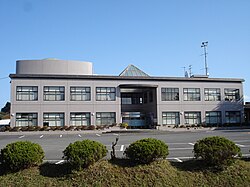
1155:
963:
1073:
842:
1043:
1013:
1008:
953:
887:
643:
427:
192:
1053:
1048:
247:
793:
1114:
863:
623:
377:
365:
197:
1248:
1172:
1109:
1058:
938:
1201:
1196:
1131:
1104:
1083:
1003:
978:
948:
835:
753:
432:
422:
389:
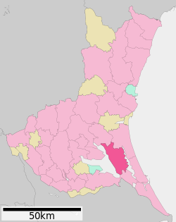
325:
1078:
1063:
1023:
998:
968:
747:
459:
Per
Japanese census data, the population of Namegata has declined over the past 40 years.
417:
361:
39:
958:
185:
1189:
1160:
983:
412:
271:
804:
1227:
1148:
1136:
1028:
1018:
895:
872:
759:
651:
635:
615:
397:
259:
1126:
393:
663:
614:, portions of what later became the city of Namegata were under the control of
320:
639:
619:
611:
373:
988:
151:
138:
1068:
238:
973:
943:
1038:
922:
819:
310:
993:
388:
Namegata is located in south-central
Ibaraki Prefecture, bordered by
243:
369:
331:
319:
282:
173:
1184:
476:
831:
688:
Namegata does not have any commercial passenger rail service.
471:
372:. As of 1 July 2020, the city had an estimated
662:
The economy of
Namegata is primarily agriculture, with
638:
form of government with a directly elected mayor and a
1092:
931:
913:
886:
304:
296:
288:
278:
266:
254:
237:
229:
221:
216:
208:
203:
191:
179:
167:
21:
666:on Lake Kasumigaura taking a predominant role.
351:
345:
27:
843:
300:Aso 1561-9, Namegat-shi, Ibaraki-ken 311-3892
8:
462:
850:
836:
828:
461:
93:Location of Namegata in Ibaraki Prefecture
18:
781:"Ibaraki prefectural official statistics"
724:Namegata has many attractions including:
772:
303:
287:
236:
215:
202:
166:
131:
97:
85:
57:
45:
212:222.48 km (85.90 sq mi)
1215:List of mergers in Ibaraki Prefecture
376:of 32,144 in 11,412 households and a
295:
277:
265:
253:
228:
220:
207:
190:
178:
7:
1244:Populated places established in 2005
14:
904:
858:
708:
698:
111:
110:
103:
87:
72:
62:
47:
805:Namegata population statistics
762:, professional football player
336:Lake Kasumigaura from Namegata
1:
1239:2005 establishments in Japan
1234:Cities in Ibaraki Prefecture
352:
1265:
742:Noted people from Namegata
404:Surrounding municipalities
1212:
902:
870:
489:—
445:Humid continental climate
346:
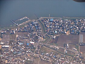
324:Aerial view of marina on
132:
98:
86:
58:
46:
37:
28:
734:Namegata Farmers Village
152:35.990500°N 140.489028°E
25:
1100:Higashiibaraki District
731:Kasumigaura Fureai Land
714:National Route 355
704:National Route 354
233:140/km (370/sq mi)
337:
329:
794:Namegata climate data
783:(in Japanese). Japan.
463:Historical population
335:
323:
157:35.990500; 140.489028
728:Hitachi Seaside Park
644:Ibaraki 2nd district
230: • Density
16:City in Kantō, Japan
464:
408:Ibaraki Prefecture
248:Japan Standard Time
148: /
864:Ibaraki Prefecture
624:Tokugawa shogunate
378:population density
366:Ibaraki Prefecture
338:
330:
222: • Total
209: • Total
53:Namegata city hall
1221:
1220:
1144:Kitasōma District
1122:Inashiki District
881:
750:, actress, singer
720:Local attractions
603:
602:
318:
317:
289:Phone number
1256:
1180:Sashima District
908:
875:
862:
852:
845:
838:
829:
824:
820:Official website
807:
802:
796:
791:
785:
784:
777:
754:Fukushiro Nukaga
737:Sairen-ji Temple
712:
711:
702:
701:
478:
473:
465:
392:to the east and
390:Lake Kasumigaura
359:
358:
355:
349:
348:
326:Lake Kasumigaura
314:
313:
311:Official website
163:
162:
160:
159:
158:
153:
149:
146:
145:
144:
141:
114:
113:
107:
91:
76:
66:
51:
32:
31:
30:
19:
1264:
1263:
1259:
1258:
1257:
1255:
1254:
1253:
1224:
1223:
1222:
1217:
1208:
1088:
927:
909:
900:
882:
866:
856:
822:
816:
811:
810:
803:
799:
792:
788:
779:
778:
774:
769:
748:Hiromi Nagasaku
744:
722:
709:
699:
695:
685:
680:
672:
660:
634:Namegata has a
632:
608:
457:
443:Namegata has a
441:
406:
386:
356:
343:
309:
308:
156:
154:
150:
147:
142:
139:
137:
135:
134:
128:
127:
126:
125:
122:
121:
120:
119:
115:
94:
82:
81:
80:
79:
70:
69:
54:
42:
33:
26:
24:
17:
12:
11:
5:
1262:
1260:
1252:
1251:
1246:
1241:
1236:
1226:
1225:
1219:
1218:
1213:
1210:
1209:
1207:
1206:
1205:
1204:
1194:
1193:
1192:
1187:
1177:
1176:
1175:
1165:
1164:
1163:
1153:
1152:
1151:
1141:
1140:
1139:
1134:
1129:
1119:
1118:
1117:
1112:
1107:
1096:
1094:
1090:
1089:
1087:
1086:
1081:
1076:
1071:
1066:
1061:
1056:
1051:
1046:
1041:
1036:
1031:
1026:
1021:
1016:
1011:
1006:
1001:
996:
991:
986:
981:
976:
971:
966:
961:
956:
951:
946:
941:
935:
933:
929:
928:
926:
925:
919:
917:
911:
910:
903:
901:
899:
898:
892:
890:
884:
883:
871:
868:
867:
857:
855:
854:
847:
840:
832:
826:
825:
815:
814:External links
812:
809:
808:
797:
786:
771:
770:
768:
765:
764:
763:
757:
751:
743:
740:
739:
738:
735:
732:
729:
721:
718:
717:
716:
706:
694:
691:
690:
689:
684:
681:
679:
678:Transportation
676:
671:
668:
659:
656:
631:
628:
607:
604:
601:
600:
597:
594:
590:
589:
586:
583:
579:
578:
575:
572:
568:
567:
564:
561:
557:
556:
553:
550:
546:
545:
542:
539:
535:
534:
531:
528:
524:
523:
520:
517:
513:
512:
509:
506:
502:
501:
498:
495:
491:
490:
487:
484:
480:
479:
474:
469:
456:
453:
440:
437:
436:
435:
430:
425:
420:
415:
405:
402:
385:
382:
316:
315:
306:
302:
301:
298:
294:
293:
290:
286:
285:
280:
276:
275:
272:Lilium auratum
268:
264:
263:
256:
252:
251:
241:
235:
234:
231:
227:
226:
223:
219:
218:
214:
213:
210:
206:
205:
201:
200:
195:
189:
188:
183:
177:
176:
171:
165:
164:
130:
129:
123:
117:
116:
109:
108:
102:
101:
100:
99:
96:
95:
92:
84:
83:
77:
71:
67:
61:
60:
59:
56:
55:
52:
44:
43:
38:
35:
34:
22:
15:
13:
10:
9:
6:
4:
3:
2:
1261:
1250:
1247:
1245:
1242:
1240:
1237:
1235:
1232:
1231:
1229:
1216:
1211:
1203:
1200:
1199:
1198:
1197:Yūki District
1195:
1191:
1188:
1186:
1183:
1182:
1181:
1178:
1174:
1171:
1170:
1169:
1168:Naka District
1166:
1162:
1159:
1158:
1157:
1156:Kuji District
1154:
1150:
1147:
1146:
1145:
1142:
1138:
1135:
1133:
1130:
1128:
1125:
1124:
1123:
1120:
1116:
1113:
1111:
1108:
1106:
1103:
1102:
1101:
1098:
1097:
1095:
1091:
1085:
1082:
1080:
1077:
1075:
1072:
1070:
1067:
1065:
1062:
1060:
1057:
1055:
1052:
1050:
1047:
1045:
1042:
1040:
1037:
1035:
1032:
1030:
1027:
1025:
1022:
1020:
1017:
1015:
1012:
1010:
1007:
1005:
1002:
1000:
997:
995:
992:
990:
987:
985:
982:
980:
977:
975:
972:
970:
967:
965:
962:
960:
957:
955:
952:
950:
947:
945:
942:
940:
937:
936:
934:
930:
924:
921:
920:
918:
916:
912:
907:
897:
894:
893:
891:
889:
885:
879:
874:
869:
865:
861:
853:
848:
846:
841:
839:
834:
833:
830:
823:(in Japanese)
821:
818:
817:
813:
806:
801:
798:
795:
790:
787:
782:
776:
773:
766:
761:
760:Hideaki Ozawa
758:
755:
752:
749:
746:
745:
741:
736:
733:
730:
727:
726:
725:
719:
715:
707:
705:
697:
696:
692:
687:
686:
682:
677:
675:
669:
667:
665:
657:
655:
653:
652:Diet of Japan
649:
645:
641:
637:
636:mayor-council
629:
627:
625:
621:
620:feudal domain
617:
613:
605:
598:
595:
592:
591:
587:
584:
581:
580:
576:
573:
570:
569:
565:
562:
559:
558:
554:
551:
548:
547:
543:
540:
537:
536:
532:
529:
526:
525:
521:
518:
515:
514:
510:
507:
504:
503:
499:
496:
493:
492:
488:
485:
482:
481:
475:
470:
467:
466:
460:
454:
452:
450:
446:
438:
434:
431:
429:
426:
424:
421:
419:
416:
414:
411:
410:
409:
403:
401:
399:
395:
391:
383:
381:
379:
375:
371:
367:
363:
354:
342:
334:
327:
322:
312:
307:
299:
291:
284:
281:
274:
273:
269:
262:
261:
260:Ginkgo biloba
257:
249:
245:
242:
240:
232:
224:
211:
199:
196:
194:
187:
184:
182:
175:
172:
170:
161:
143:140°29′20.5″E
133:Coordinates:
106:
90:
75:
65:
50:
41:
36:
20:
1074:Tsukubamirai
1033:
959:Hitachiōmiya
915:Special city
800:
789:
775:
756:, politician
723:
673:
661:
633:
609:
458:
455:Demographics
448:
442:
407:
394:Lake Kitaura
387:
353:Namegata-shi
340:
339:
292:0299-72-0811
270:
258:
140:35°59′25.8″N
1014:Kitaibaraki
1009:Kasumigaura
954:Hitachinaka
664:aquaculture
648:lower house
610:During the
428:Kasumigaura
364:located in
328:in Namegata
155: /
1228:Categories
1054:Shimotsuma
1049:Sakuragawa
964:Hitachiōta
767:References
640:unicameral
630:Government
622:under the
616:Asō Domain
612:Edo period
374:population
217:Population
193:Prefecture
1115:Shirosato
1093:Districts
1069:Tsuchiura
1044:Ryūgasaki
888:Core city
670:Education
384:Geography
239:Time zone
1249:Namegata
1059:Takahagi
1034:Namegata
974:Inashiki
944:Chikusei
447:(Köppen
341:Namegata
118:Namegata
23:Namegata
1202:Yachiyo
1132:Kawachi
1105:Ibaraki
1039:Omitama
1004:Kashima
979:Ishioka
949:Hitachi
923:Tsukuba
878:capital
693:Highway
683:Railway
658:Economy
650:of the
646:of the
606:History
439:Climate
433:Omitama
423:Kashima
305:Website
297:Address
198:Ibaraki
169:Country
1079:Ushiku
1064:Toride
1024:Moriya
999:Kasama
994:Kamisu
969:Hokota
932:Cities
599:−14.4%
596:32,185
585:37,611
574:41,465
563:42,990
552:42,660
544:−10.4%
541:42,589
530:47,549
522:+27.7%
519:49,391
508:38,680
497:35,996
486:33,789
418:Hokota
267:Flower
225:31,960
181:Region
124:
1190:Sakai
1173:Tōkai
1161:Daigo
1110:Ōarai
984:Itako
939:Bandō
593:2020
588:−9.3%
582:2010
577:−3.5%
571:2000
566:+0.8%
560:1990
555:+0.2%
549:1980
538:1970
533:−3.7%
527:1960
516:1950
511:+7.5%
505:1940
500:+6.5%
494:1930
483:1920
413:Itako
370:Japan
360:is a
283:Egret
244:UTC+9
186:Kantō
174:Japan
1185:Goka
1149:Tone
1137:Miho
1084:Yūki
1029:Naka
1019:Koga
989:Jōsō
896:Mito
873:Mito
618:, a
472:Pop.
468:Year
398:Mito
362:city
279:Bird
255:Tree
204:Area
78:Seal
68:Flag
40:City
1127:Ami
449:Cfa
347:行方市
29:行方市
1230::
654:.
477:±%
400:.
368:,
350:,
880:)
876:(
851:e
844:t
837:v
357:)
344:(
250:)
246:(
Text is available under the Creative Commons Attribution-ShareAlike License. Additional terms may apply.