40:
20:
291:
238:
28:
332:
275:
361:
351:
325:
168:
268:
202:
210:
190:
198:
Scale 1:250000 topographic map of
Antarctica. Scientific Committee on Antarctic Research (SCAR). Since 1993, regularly upgraded and updated.
175:
356:
318:
164:
Mapa topográfico de escala 1:25000. Madrid: Servicio Geográfico del Ejército, 1991. (Map reproduced on p. 16 of the linked work)
261:
226:
108:
83:
161:
59:
222:
39:
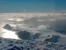
298:
206:
186:
55:
19:
302:
245:
178:. Scale 1:100000 topographic map. Sofia: Antarctic Place-names Commission of Bulgaria, 2005.
171:. Scale 1:25000 topographic map. Sofia: Antarctic Place-names Commission of Bulgaria, 1996.
137:
79:
75:
32:
290:
145:
141:
67:
51:
237:
345:
94:
71:
149:
70:
to the north by a 1.5 km ice-covered col, and by an ice-covered saddle to
63:
185:. Scale 1:120000 topographic map. Troyan: Manfred Wörner Foundation, 2009.
123:
110:
27:
183:
Antarctica: Livingston Island and
Greenwich, Robert, Snow and Smith Islands
176:
Antarctica: Livingston Island and
Greenwich Island, South Shetland Islands
89:
The feature is named after
Captain William Napier, Master of the schooner
244:
This
Antarctica mountain, mountain range, or peak related article is a
205:. Scale 1:100000 topographic map. Manfred Wörner Foundation, 2017.
38:
26:
18:
152:(Spanish mapping in 1991, and Bulgarian in 1996, 2005 and 2009).
16:
Mountain in
Livingston Island, South Shetland Islands, Antarctica
182:
195:
23:
Location of Hurd
Peninsula in the South Shetland Islands.
306:
249:
43:
Topographic map of
Livingston Island and Smith Island.
97:, who visited the South Shetland Islands in 1820–21.
50:is the partly ice-free peak rising to 380 m on
203:Antarctica: Livingston Island and Smith Island
326:
269:
8:
333:
319:
276:
262:
169:Livingston Island: Central-Eastern Region
74:to the south-southwest, and surmounts
7:
287:
285:
234:
232:
148:and 2.2 km north-northeast of
136:which is 2.05 km southeast of
305:. You can help Knowledge (XXG) by
248:. You can help Knowledge (XXG) by
14:
362:Livingston Island geography stubs
227:Composite Gazetteer of Antarctica
196:Antarctic Digital Database (ADD).
289:
236:
162:Isla Livingston: Península Hurd.
31:Napier Peak (on the right) from
352:Mountains of Livingston Island
1:
144:, 6.79 km northwest of
140:, 3.21 km southwest of
78:to the northwest and west,
378:
284:
231:
357:Antarctica mountain stubs
124:62.671500°S 60.325139°W
105:The peak is located at
301:location article is a
129:-62.671500; -60.325139
60:South Shetland Islands
44:
36:
24:
42:
30:
22:
174:L.L. Ivanov et al.
120: /
66:. It is linked to
45:
37:
25:
314:
313:
299:Livingston Island
257:
256:
211:978-619-90008-3-0
191:978-954-92032-6-4
82:to the east, and
56:Livingston Island
369:
335:
328:
321:
293:
286:
278:
271:
264:
240:
233:
135:
134:
132:
131:
130:
125:
121:
118:
117:
116:
113:
80:Huntress Glacier
76:Johnsons Glacier
377:
376:
372:
371:
370:
368:
367:
366:
342:
341:
340:
339:
283:
282:
219:
158:
128:
126:
122:
119:
114:
111:
109:
107:
106:
103:
33:Mount Friesland
17:
12:
11:
5:
375:
373:
365:
364:
359:
354:
344:
343:
338:
337:
330:
323:
315:
312:
311:
294:
281:
280:
273:
266:
258:
255:
254:
241:
230:
229:
218:
215:
214:
213:
199:
193:
179:
172:
165:
157:
154:
146:St. Cyril Peak
142:Willan Nunatak
102:
99:
86:to the south.
52:Hurd Peninsula
15:
13:
10:
9:
6:
4:
3:
2:
374:
363:
360:
358:
355:
353:
350:
349:
347:
336:
331:
329:
324:
322:
317:
316:
310:
308:
304:
300:
295:
292:
288:
279:
274:
272:
267:
265:
260:
259:
253:
251:
247:
242:
239:
235:
228:
224:
221:
220:
216:
212:
208:
204:
201:L.L. Ivanov.
200:
197:
194:
192:
188:
184:
181:L.L. Ivanov.
180:
177:
173:
170:
167:L.L. Ivanov.
166:
163:
160:
159:
155:
153:
151:
147:
143:
139:
138:Charrúa Ridge
133:
100:
98:
96:
92:
87:
85:
81:
77:
73:
69:
65:
61:
57:
53:
49:
41:
34:
29:
21:
307:expanding it
296:
250:expanding it
243:
223:Napier Peak.
115:60°19′30.5″W
112:62°40′17.4″S
104:
90:
88:
72:Mirador Hill
47:
46:
150:Moores Peak
127: /
68:Charrúa Gap
48:Napier Peak
346:Categories
217:References
64:Antarctica
84:False Bay
101:Location
95:New York
93:, from
58:in the
209:
189:
297:This
225:SCAR
91:Venus
303:stub
246:stub
207:ISBN
187:ISBN
156:Maps
348::
62:,
54:,
334:e
327:t
320:v
309:.
277:e
270:t
263:v
252:.
35:.
Text is available under the Creative Commons Attribution-ShareAlike License. Additional terms may apply.

