83:
59:
404:
269:
90:
332:
is named after a St Nem, although he was not certain which one. He was aware of four saints called Ném and another three called Némán and preferred the latter as this name is a "diminutive of Ném". Mac an Tàilleir (2003) follows this and gives a derivation from "Ném's island".
319:
The area of the island is recorded as 40 hectares (99 acres) in Rick
Livingstone's tables, and Nave Island is also included by Hamish Haswell-Smith in his tabulation of Scottish islands of equal to or greater than 40 hectares (99 acres) in size.
307:
The island is all but cut in two by a narrow chasm that runs northwest to southeast across the northern third. The highest point is just north of this embayment at 34 metres (112 ft) above sea level. To the southwest lie a number of
389:
wrote: "on the north coist of Ila, beside the entresse of
Lochgrunord, layes ane iyle, called by the Erish Ellan-nese, with ane kirke in it. This iyle is half ane myle in lenthe, fair maynland, inhabit and manurit, guid for fishing."
541:
455:
Haswell-Smith describes the measurement that gave rise to this addition to his list of islands at
Haswell-Smith (2015) p. xii. Livingstone is not specific about his method of calculation.
1390:
368:
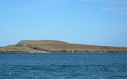
at an early date. There is a ruined chapel immediately to the south of the cross-island chasm and an earthen rampart surrounding it hint at a monastic settlement.
117:
82:
748:
58:
828:
430:
was not as important on Islay as elsewhere and the industry collapsed suddenly throughout
Scotland in 1830 after the removal of tariffs on imported
1351:
1395:
778:
727:
312:
and islets. These include
Boghachan Mòra, Eilean Beag, Sgeireann Leathann, Sgeir nan Sgarbh and the Na Badagan rocks between the island and
795:
764:
434:. The only remaining substantial evidence of its existence on Islay and environs are a furnace and traces of kilns on Nave Island.
364:
at
Kilnave on the shores of Loch Gruinart and the fragment of another found on the island itself suggest the presence of organised
230:
111:
821:
662:
125:
545:
1301:
1316:
1296:
737:
252:
218:
476:, with a church on it. This isle is half a mile in length, fair land, inhabited and manured, good for fishing.
1241:
1005:
814:
132:
1246:
965:
851:
585:
970:
1023:
899:
1236:
1321:
1115:
1038:
879:
1231:
743:
506:
386:
400:
listed seven churches on Islay at the end of the 17th century, including a chapel on Nave Island.
980:
581:
1085:
521:
1110:
1080:
894:
791:
783:
774:
760:
723:
696:
Duncan, P. J. "The
Industries of Argyll: Tradition and Improvement" in Omand (2006) pp. 156–57
1306:
1075:
995:
869:
565:
1273:
1213:
1178:
990:
960:
561:
223:
34:
500:
1283:
1183:
1105:
1070:
1065:
985:
933:
884:
465:
334:
292:
245:
1384:
1291:
1268:
1120:
1090:
1053:
469:
415:
407:
397:
352:
and means "height of the saint"—a much more general ecclesiastical derivation.
313:
296:
64:
1311:
1198:
1168:
1143:
1135:
1125:
975:
365:
361:
342:
20:
1148:
1095:
1057:
928:
391:
1226:
1188:
403:
369:
1366:
1353:
147:
134:
952:
1221:
1013:
948:
874:
623:
427:
235:
687:
Thomson, William P. L. "Agricultural
Improvement" in Omand (2003) p. 98.
1163:
1100:
1018:
920:
374:
1193:
1158:
904:
846:
431:
309:
348:
However, King and Cotter (2012) suggest that
Ardnave Point is from
1337:
1260:
1153:
1043:
1028:
938:
861:
411:
402:
338:
288:
172:
806:
1256:
1203:
1173:
1033:
909:
626:(trans. Whitely Stokes). CELT. p. 140. Retrieved 5 January 2015.
423:
810:
524:(pdf) Argyll Yacht Charters. Retrieved 23 September 2013. .
394:'s Atlas of 1654 refers to the island as "Ylen Naomh".
522:"Rick Livingstone’s Tables of the Islands of Scotland"
468:: on the north coast of Islay, beside the entrance to
40:
1330:
1282:
1255:
1212:
1134:
1052:
1004:
947:
918:
860:
275:
266:
258:
251:
241:
229:
217:
212:
204:
196:
178:
168:
163:
124:
110:
71:
48:
33:
316:on Islay. The Balach Rocks lie to the northeast.
345:, died 14 June 654 is presumably a contender.
822:
8:
749:Description of the Western Isles of Scotland
720:Islay, Jura and Colonsay: A Historical Guide
28:
669:. Wikimedia Commons. Retrieved 2 June 2012.
67:with the ruined chapel just visible at left
829:
815:
807:
752:. William Auld. Edinburgh - 1774 edition.
27:
732:King, Jacob and Cotter, Michelle (2012)
495:
493:
426:boom that influenced the economy of the
102:Nave Island shown within Argyll and Bute
540:islands over 20 ha in extent and
489:
448:
1391:Uninhabited islands of Argyll and Bute
517:
515:
533:Area and population ranks: there are
7:
624:The Martyrology of Oengus the Culdee
556:
554:
360:The presence of substantial carved
89:
788:The Celtic Place-Names of Scotland
509:. Retrieved 26 August 2012. p. 91
23:off the north coast of Sutherland.
14:
605:Haswell-Smith (2015) pp. xii, 530
472:, lies an isle, called in Gaelic
542:93 permanently inhabited islands
267:
88:
81:
57:
268:
47:
418:and Nave Island at left centre
1:
1396:Islands of the Inner Hebrides
734:Place-names in Islay and Jura
635:King and Cotter (2012) p. 34
534:
499:Mac an Tàilleir, Iain (2003)
382:that may refer to this site.
769:Omand, Donald (ed.) (2006)
755:Omand, Donald (ed.) (2003)
705:Caldwell (2011) pp. 92, 209
1412:
718:Caldwell, David H. (2011)
653:Monro (1549) "Nese" no. 80
328:Watson (1926) states that
18:
842:
738:Scottish Natural Heritage
678:Caldwell (2011) pp. 68–69
570:(Map). 1:25,000. Leisure.
378:refers to a monastery at
76:
56:
19:Not to be confused with
798:. First published 1926.
502:Ainmean-àite/Placenames
208:34 m (112 ft)
1317:Sgat Mòr and Sgat Beag
966:Eilean Ceann na Creige
790:. Edinburgh. Birlinn.
773:. Edinburgh. Birlinn.
759:. Edinburgh. Birlinn.
722:. Edinburgh. Birlinn.
586:Gazetteer for Scotland
422:The late 18th-century
419:
41:
644:Caldwell (2011) p. 25
406:
299:. It is uninhabited.
287:lies to the north of
880:Eilean Mhic Coinnich
614:Watson (1926) p. 307
372:'s late 7th-century
1363: /
1232:Cairn na Burgh Beag
544:were listed in the
507:Pàrlamaid na h-Alba
144: /
30:
1237:Cairn na Burgh Mòr
981:Eilean Mhic Chrion
420:
414:from the air with
335:St Nem Mac Ua Birn
295:near the mouth of
164:Physical geography
16:Island in Scotland
1346:
1345:
1081:Eileach an Naoimh
779:978-1-84158-480-5
744:Monro, Sir Donald
728:978-1-84158-961-9
667:Atlas of Scotland
464:Translation from
282:
281:
205:Highest elevation
192: sq mi)
112:OS grid reference
63:Nave Island from
1403:
1378:
1377:
1375:
1374:
1373:
1368:
1367:55.900°N 6.333°W
1364:
1361:
1360:
1359:
1356:
996:MacCormaig Isles
971:Eilean dà Mhèinn
870:Am Fraoch Eilean
831:
824:
817:
808:
706:
703:
697:
694:
688:
685:
679:
676:
670:
660:
654:
651:
645:
642:
636:
633:
627:
621:
615:
612:
606:
603:
597:
596:
594:
592:
578:
572:
571:
558:
549:
539:
536:
531:
525:
519:
510:
497:
477:
462:
456:
453:
271:
270:
191:
190:
186:
159:
158:
156:
155:
154:
149:
145:
142:
141:
140:
137:
120:
92:
91:
85:
61:
44:
31:
1411:
1410:
1406:
1405:
1404:
1402:
1401:
1400:
1381:
1380:
1371:
1369:
1365:
1362:
1357:
1354:
1352:
1350:
1349:
1347:
1342:
1326:
1278:
1251:
1214:Treshnish Isles
1208:
1179:Little Colonsay
1130:
1086:Eilean Dubh Mòr
1048:
1000:
991:Island Macaskin
943:
914:
856:
838:
835:
805:
771:The Argyll Book
757:The Orkney Book
715:
710:
709:
704:
700:
695:
691:
686:
682:
677:
673:
661:
657:
652:
648:
643:
639:
634:
630:
622:
618:
613:
609:
604:
600:
590:
588:
580:
579:
575:
562:Ordnance Survey
560:
559:
552:
537:
532:
528:
520:
513:
498:
491:
486:
481:
480:
463:
459:
454:
450:
445:
440:
358:
326:
305:
242:Sovereign state
224:Argyll and Bute
188:
184:
183:
152:
150:
146:
143:
138:
135:
133:
131:
130:
116:
106:
105:
104:
103:
100:
99:
98:
97:
93:
62:
49:Meaning of name
35:Scottish Gaelic
24:
17:
12:
11:
5:
1409:
1407:
1399:
1398:
1393:
1383:
1382:
1372:55.900; -6.333
1344:
1343:
1341:
1340:
1334:
1332:
1328:
1327:
1325:
1324:
1319:
1314:
1309:
1304:
1299:
1294:
1288:
1286:
1284:Firth of Clyde
1280:
1279:
1277:
1276:
1271:
1265:
1263:
1253:
1252:
1250:
1249:
1244:
1239:
1234:
1229:
1224:
1218:
1216:
1210:
1209:
1207:
1206:
1201:
1196:
1191:
1186:
1184:Samalan Island
1181:
1176:
1171:
1166:
1161:
1156:
1151:
1146:
1140:
1138:
1132:
1131:
1129:
1128:
1123:
1118:
1113:
1108:
1103:
1098:
1093:
1088:
1083:
1078:
1073:
1071:Castle Stalker
1068:
1066:Bernera Island
1062:
1060:
1050:
1049:
1047:
1046:
1041:
1036:
1031:
1026:
1021:
1016:
1010:
1008:
1002:
1001:
999:
998:
993:
988:
983:
978:
973:
968:
963:
957:
955:
953:Loch Craignish
945:
944:
942:
941:
936:
931:
925:
923:
916:
915:
913:
912:
907:
902:
897:
892:
887:
882:
877:
872:
866:
864:
858:
857:
855:
854:
852:Inner Hebrides
849:
843:
840:
839:
837:Argyll Islands
836:
834:
833:
826:
819:
811:
804:
803:External links
801:
800:
799:
781:
767:
753:
741:
730:
714:
711:
708:
707:
698:
689:
680:
671:
655:
646:
637:
628:
616:
607:
598:
573:
567:OS Maps Online
550:
526:
511:
488:
487:
485:
482:
479:
478:
457:
447:
446:
444:
441:
439:
436:
410:and northwest
357:
354:
350:Àird an Naoimh
325:
322:
304:
301:
293:Inner Hebrides
280:
279:
277:
273:
272:
264:
263:
260:
256:
255:
249:
248:
246:United Kingdom
243:
239:
238:
233:
227:
226:
221:
215:
214:
213:Administration
210:
209:
206:
202:
201:
198:
194:
193:
180:
176:
175:
170:
166:
165:
161:
160:
128:
122:
121:
114:
108:
107:
101:
95:
94:
87:
86:
80:
79:
78:
77:
74:
73:
69:
68:
54:
53:
52:"Ném's island"
50:
46:
45:
38:
15:
13:
10:
9:
6:
4:
3:
2:
1408:
1397:
1394:
1392:
1389:
1388:
1386:
1379:
1376:
1339:
1336:
1335:
1333:
1329:
1323:
1320:
1318:
1315:
1313:
1310:
1308:
1305:
1303:
1300:
1298:
1295:
1293:
1290:
1289:
1287:
1285:
1281:
1275:
1272:
1270:
1269:Eilean Ornsay
1267:
1266:
1264:
1262:
1258:
1254:
1248:
1245:
1243:
1240:
1238:
1235:
1233:
1230:
1228:
1225:
1223:
1220:
1219:
1217:
1215:
1211:
1205:
1202:
1200:
1197:
1195:
1192:
1190:
1187:
1185:
1182:
1180:
1177:
1175:
1172:
1170:
1167:
1165:
1162:
1160:
1157:
1155:
1152:
1150:
1147:
1145:
1142:
1141:
1139:
1137:
1133:
1127:
1124:
1122:
1121:Maiden Island
1119:
1117:
1114:
1112:
1109:
1107:
1104:
1102:
1099:
1097:
1094:
1092:
1091:Garbh Eileach
1089:
1087:
1084:
1082:
1079:
1077:
1076:Dùn Chonnuill
1074:
1072:
1069:
1067:
1064:
1063:
1061:
1059:
1055:
1054:Firth of Lorn
1051:
1045:
1042:
1040:
1037:
1035:
1032:
1030:
1027:
1025:
1022:
1020:
1017:
1015:
1012:
1011:
1009:
1007:
1006:Slate Islands
1003:
997:
994:
992:
989:
987:
984:
982:
979:
977:
974:
972:
969:
967:
964:
962:
959:
958:
956:
954:
950:
946:
940:
937:
935:
932:
930:
927:
926:
924:
922:
917:
911:
908:
906:
903:
901:
898:
896:
893:
891:
888:
886:
883:
881:
878:
876:
873:
871:
868:
867:
865:
863:
859:
853:
850:
848:
845:
844:
841:
832:
827:
825:
820:
818:
813:
812:
809:
802:
797:
796:1-84158-323-5
793:
789:
785:
784:Watson, W. J.
782:
780:
776:
772:
768:
766:
765:1-84158-254-9
762:
758:
754:
751:
750:
745:
742:
739:
735:
731:
729:
725:
721:
717:
716:
712:
702:
699:
693:
690:
684:
681:
675:
672:
668:
664:
659:
656:
650:
647:
641:
638:
632:
629:
625:
620:
617:
611:
608:
602:
599:
587:
583:
582:"Nave Island"
577:
574:
569:
568:
563:
557:
555:
551:
547:
543:
530:
527:
523:
518:
516:
512:
508:
504:
503:
496:
494:
490:
483:
475:
471:
470:Loch Gruinart
467:
461:
458:
452:
449:
442:
437:
435:
433:
429:
425:
417:
416:Ardnave Point
413:
409:
408:Loch Gruinart
405:
401:
399:
398:Martin Martin
395:
393:
388:
383:
381:
377:
376:
375:Vita Columbae
371:
367:
363:
355:
353:
351:
346:
344:
340:
336:
331:
323:
321:
317:
315:
314:Ardnave Point
311:
302:
300:
298:
297:Loch Gruinart
294:
290:
286:
278:
274:
265:
261:
257:
254:
250:
247:
244:
240:
237:
234:
232:
228:
225:
222:
220:
216:
211:
207:
203:
199:
195:
181:
177:
174:
171:
167:
162:
157:
148:55.9°N 6.33°W
129:
127:
123:
119:
115:
113:
109:
84:
75:
70:
66:
65:Ardnave Point
60:
55:
51:
43:
39:
36:
32:
26:
22:
1348:
1322:Sheep Island
1297:Eilean Dearg
1199:Torran Rocks
1169:Inch Kenneth
1144:Calve Island
1126:Shuna Island
976:Eilean Loain
889:
787:
770:
756:
747:
733:
719:
713:Bibliography
701:
692:
683:
674:
666:
663:"Ila Insula"
658:
649:
640:
631:
619:
610:
601:
589:. Retrieved
576:
566:
529:
501:
473:
460:
451:
421:
396:
384:
380:Elena Insula
379:
373:
366:Christianity
362:Celtic cross
359:
349:
347:
330:Eilean Nèimh
329:
327:
318:
306:
284:
283:
253:Demographics
219:Council area
200:220=
182:40 ha (
169:Island group
42:Eilean Nèimh
25:
21:Neave Island
1370: /
1302:Eilean Dubh
1149:Dubh Artach
1106:Lady's Rock
1096:Insh Island
1058:Loch Linnhe
986:Eilean Rìgh
890:Nave Island
591:22 November
546:2011 census
392:Johan Blaeu
285:Nave Island
153:55.9; -6.33
151: /
126:Coordinates
96:Nave Island
29:Nave Island
1385:Categories
1189:Skerryvore
665:. Blaeu's
538: 300
474:Ellan-nese
438:References
387:Dean Monro
276:References
259:Population
1307:Glunimore
736:. Perth.
484:Citations
385:In 1549,
324:Etymology
303:Geography
197:Area rank
1222:Bac Beag
1014:Belnahua
949:Knapdale
919:West of
875:Colonsay
505:. (pdf)
428:Hebrides
310:skerries
236:Scotland
118:NR292759
72:Location
1355:55°54′N
1331:Unknown
1227:Bac Mòr
1164:Gometra
1111:Lismore
1101:Kerrera
1019:Easdale
934:Gigalum
921:Kintyre
895:Oronsay
786:(2004)
746:(1549)
370:Adomnán
356:History
291:in the
231:Country
187:⁄
136:55°54′N
1358:6°20′W
1292:Davaar
1242:Fladda
1194:Staffa
1159:Erraid
1024:Fladda
905:Scarba
847:Argyll
794:
777:
763:
726:
432:alkali
139:6°20′W
1338:Hinba
1312:Sanda
1274:Gunna
1261:Tiree
1247:Lunga
1154:Eorsa
1116:Lunga
1044:Torsa
1039:Shuna
1029:Luing
961:Danna
939:Gigha
900:Orsay
862:Islay
466:Scots
443:Notes
412:Islay
339:Abbot
289:Islay
173:Islay
1259:and
1257:Coll
1204:Ulva
1174:Iona
1136:Mull
1056:and
1034:Seil
951:and
929:Cara
910:Texa
885:Jura
792:ISBN
775:ISBN
761:ISBN
724:ISBN
593:2009
424:kelp
343:Aran
337:the
179:Area
37:name
341:of
1387::
584:.
564:.
553:^
535:c.
514:^
492:^
830:e
823:t
816:v
740:.
595:.
548:.
262:0
189:8
185:1
Text is available under the Creative Commons Attribution-ShareAlike License. Additional terms may apply.