42:
164:
Youghall Park. These installations were later destroyed in 1778 by
American Pirates. Fishing operations didn't resume until 1784 when Colonel Arthur Goold received most of the Eastern shore of Nepisiguit Bay forcing Acadian Settlers to settle on the Western shore of the Bay. Hugh Munro arrived in Nepisiguit area in 1794 and began a Merchant and Fish operations later expanding into lumbering. By 1818, he claimed his operation was the longest serving one in the Nepisiguit Bay. By that time, he was building ships, employing many people.
29:
211:
203:
49:
163:
was a summer home of the Mi’kmaq First Nation that they called
Nepisiguit. The first Permanent Europeans settlers from France arrived in 1619. Commodore George Walker, a successful British privateer, set up a fishing and trading operation on the Nepisiguit Bay in 1768 at the present day location of
167:
Nepisiguit Bay is a popular spot in summer with cottages lining both sides of the bay. Both
Youghall Beach in Bathurst and Beresford beach are both popular destinations for locals over the summer months.
41:
152:: Baie des Chaleurs), which extends from the Atlantic Ocean and Nepisiguit Bay is a southern arm of it, stretching between Petit-Rocher and
74:
384:
265:
389:
350:
281:
255:
180:
160:
114:
309:
261:
121:
Peters River, Millstream River, Tetagouche River, Middle River, Nepisiguit River, Little River
326:
149:
28:
210:
202:
378:
365:"Biography – MUNRO, HUGH – Volume VII (1836-1850) – Dictionary of Canadian Biography"
141:
364:
131:
145:
185:
153:
89:
76:
282:"Nepisiguit Bay, Canada - Geographical Names, map, geographic coordinates"
115:
209:
201:
214:
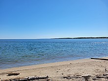
View of
Nepisiguit Bay looking North East from Youghall Beach
295:
206:
View of
Nepisiguit Bay looking North West from Youghall Beach
176:
Nepisiguit Bay is home to a number of coastal communities.
140:, which means "rough water") is located in northern
113:
105:
66:
21:
135:
67:
351:"Bathurst - at Nepisiguit pirates made history"
327:"Bathurst | New Brunswick, Canada | Britannica"
260:. University of Toronto Press. January 1996.
8:
18:
218:The following rivers flow into the bay:
321:
319:
247:
48:
144:, Canada on the southern part of the
7:
14:
159:The current site of the city of
47:
40:
27:
310:"Place names - Nepisiguit Bay"
257:Place Names of Atlantic Canada
190:LSD of New Bandon-Salmon Beach
1:
16:Bay in New Brunswick, Canada
406:
385:Geography of New Brunswick
35:
26:
136:
215:
207:
390:Bays of New Brunswick
213:
205:
193:Community Janeville
172:Coastal communities
90:47.6938°N 65.5330°W
86: /
331:www.britannica.com
296:"GeoNB Map Viewer"
216:
208:
186:Town of Belle-Baie
125:
124:
95:47.6938; -65.5330
397:
369:
368:
361:
355:
354:
347:
341:
340:
338:
337:
323:
314:
313:
306:
300:
299:
292:
286:
285:
278:
272:
271:
252:
234:Nepisiguit River
228:Tetagouche River
225:Millstream River
181:City of Bathurst
139:
117:
101:
100:
98:
97:
96:
91:
87:
84:
83:
82:
79:
69:
51:
50:
44:
31:
19:
405:
404:
400:
399:
398:
396:
395:
394:
375:
374:
373:
372:
363:
362:
358:
349:
348:
344:
335:
333:
325:
324:
317:
308:
307:
303:
294:
293:
289:
280:
279:
275:
268:
254:
253:
249:
244:
200:
174:
116:Primary inflows
94:
92:
88:
85:
80:
77:
75:
73:
72:
62:
61:
60:
59:
58:
57:
56:
52:
17:
12:
11:
5:
403:
401:
393:
392:
387:
377:
376:
371:
370:
356:
353:. 26 May 2020.
342:
315:
301:
287:
273:
266:
246:
245:
243:
240:
239:
238:
235:
232:
229:
226:
223:
199:
196:
195:
194:
191:
188:
183:
173:
170:
128:Nepisiguit Bay
123:
122:
119:
111:
110:
107:
103:
102:
70:
64:
63:
55:Nepisiguit Bay
54:
53:
46:
45:
39:
38:
37:
36:
33:
32:
24:
23:
22:Nepisiguit Bay
15:
13:
10:
9:
6:
4:
3:
2:
402:
391:
388:
386:
383:
382:
380:
366:
360:
357:
352:
346:
343:
332:
328:
322:
320:
316:
311:
305:
302:
297:
291:
288:
283:
277:
274:
269:
267:9780802075703
263:
259:
258:
251:
248:
241:
236:
233:
230:
227:
224:
221:
220:
219:
212:
204:
197:
192:
189:
187:
184:
182:
179:
178:
177:
171:
169:
165:
162:
157:
155:
151:
147:
143:
142:New Brunswick
138:
133:
129:
120:
118:
112:
108:
104:
99:
71:
65:
43:
34:
30:
25:
20:
359:
345:
334:. Retrieved
330:
304:
290:
276:
256:
250:
237:Little River
231:Middle River
222:Peters River
217:
175:
166:
158:
137:winpegijawik
127:
126:
106:Part of
146:Chaleur Bay
109:Chaleur Bay
93: /
68:Coordinates
379:Categories
336:2022-05-25
242:References
154:Stonehaven
130:(from the
81:65°31′59″W
78:47°41′38″N
161:Bathurst
132:Mi’kmaq
264:
198:Rivers
150:French
134:word
262:ISBN
381::
329:.
318:^
156:.
367:.
339:.
312:.
298:.
284:.
270:.
148:(
Text is available under the Creative Commons Attribution-ShareAlike License. Additional terms may apply.