691:
140:
1084:
1196:
1171:
1144:
1112:
912:
846:
488:
473:
337:
324:
311:
246:
233:
1248:
1223:
1039:
1011:
974:
946:
807:
794:
363:
350:
298:
285:
272:
259:
212:
1478:
38:
628:, where the concurrency with SH 32 begins. It crosses the Waikato on top of the Whakamaru hydroelectric dam and leaves SH 32 where it continues eastwards on the opposite bank of the Waikato River to SH 1 at the Ātiamuri Dam. SH 30 runs concurrently with SH 1 northwards for six kilometres. The highway leaves SH 1 at Upper Ātiamuri, and heads north-east, over the border into
151:
734:
SH 30A starts west of central
Rotorua, at the intersection of Old Taupo Road (SH 5) and Pukuatua Street. SH 30A follows Pukuatua Street eastwards, before going into an S-bend onto Amohau Street, to avoid central Rotorua. The road continues east to Fenton Street, from where SH 30A turns southwest onto
675:
SH 30's only major route change has occurred at the
Whakatane end of the highway. The highway originally ended at Paroa, where the highway met SH 2. Recently, SH 2 has been moved inland, and SH 30 was extended along SH 2's former route to Whakatane.
666:
After crossing SH 2 at
Awakeri, the highway turns north and heads towards the coast. The road then turns east, and crosses the Whakatane River. The highway ends just across the river at the roundabout with Landing Road.
738:
SH 30A was created after SH 5 was moved from its original route through central
Rotorua to Old Taupo Road. SH 30A follows part of the old SH 5 route on Amohau Street, between Ranolf Street and Fenton Street.
1391:
1416:
451:
55:
2070:
1384:
542:
At 219 kilometres, SH 30 is New
Zealand's fifth longest provincial (two-digit) state highway, after SH 25, SH 35, SH 73, and SH 94. With the exception of
735:
a dual carriageway to connect with Te Ngae Road. The highway turns eastwards again, meeting SH 30 at the intersection of Te Ngae Road and Sala Street.
1377:
2065:
620:
Near
Mangakino, SH 30 turns sharply south-east, and bypasses the town of Mangakino. Here, the highway meets the Waikato River at the top of
102:
74:
1411:
1317:
456:
1400:
512:
443:
121:
81:
639:
The highway passes through the south-east of
Rotorua, then heads north through the suburb of Te Ngae, and up the eastern side of
88:
2014:
1978:
1968:
1953:
1948:
1943:
1938:
1933:
1928:
1923:
1918:
1913:
1908:
1903:
1867:
1862:
1857:
1852:
1847:
1842:
1837:
1832:
1827:
1822:
1817:
1812:
1807:
1802:
1797:
1792:
1787:
1782:
1777:
1772:
1767:
1762:
1757:
1752:
1747:
1742:
1737:
1732:
1727:
1722:
1704:
1699:
1694:
1689:
1684:
1679:
1674:
1669:
1664:
1659:
1654:
1649:
1644:
1639:
1634:
1629:
1624:
1619:
1614:
1609:
1604:
1599:
1594:
1589:
1584:
1574:
1569:
1564:
1559:
1554:
1549:
1544:
1539:
1534:
1529:
1524:
1519:
1514:
1509:
1504:
1499:
1494:
1199:
1174:
1147:
1115:
915:
849:
570:
558:
491:
476:
340:
327:
314:
249:
236:
59:
2075:
1898:
1893:
1888:
1883:
1467:
1462:
1457:
1452:
1447:
1442:
1437:
1432:
1251:
1226:
1042:
1014:
977:
949:
810:
797:
594:
574:
566:
562:
543:
366:
353:
301:
288:
275:
262:
215:
189:
2009:
70:
1999:
644:
861:
48:
2039:
2004:
2019:
2029:
598:
899:
875:
95:
2044:
1983:
1259:
1092:
1046:
985:
923:
818:
750:
1128:
606:
2024:
1958:
2034:
1963:
610:
164:
1298:
554:
871:
828:
1337:
776:
660:
17:
1338:"State Highways: Numbers Used, Location Descriptors, and Lengths (As at January 2004)"
2059:
995:
891:
887:
814:
629:
621:
614:
520:
1255:
690:
1714:
1486:
801:
648:
640:
547:
139:
1477:
536:
1973:
933:
781:
652:
590:
524:
416:
400:
279:
266:
219:
37:
857:
602:
1369:
1269:
833:
625:
528:
412:
381:
253:
240:
1230:
1178:
1119:
1018:
953:
853:
318:
546:, it has junctions with every national (one-digit) state highway in the
150:
1210:
1151:
1088:
1063:
981:
919:
715:
711:
656:
633:
586:
557:
of all the state highways. It shares sections with, from west to east,
532:
516:
424:
420:
370:
357:
344:
331:
305:
292:
605:. The highway then leaves the railway and turns east, crossing into
1245:
1220:
1193:
1168:
1036:
1008:
971:
943:
909:
843:
731:
SH 30 has one spur route – State
Highway 30A (SH 30A) in Rotorua.
1373:
655:. The road turns north-east passing north of the mill town of
31:
1364:
643:. Turning east, the road skims the southern edge of Lakes
1263:
1234:
1204:
1182:
1050:
1022:
989:
957:
927:
865:
1992:
1876:
1713:
1485:
1425:
721:
706:
686:
434:
406:
396:
391:
376:
225:
206:
201:
178:
170:
157:
136:
62:. Unsourced material may be challenged and removed.
613:. The road now turns north-east and heads for the
1417:List of motorways and expressways in New Zealand
1385:
8:
1392:
1378:
1370:
746:
465:
122:Learn how and when to remove this message
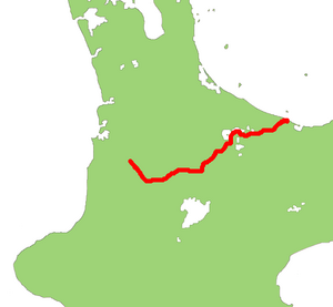
585:SH 30 starts in the southern end of the
1329:
683:
133:
2071:Transport in the Bay of Plenty Region
1279:
1273:
1239:
1214:
1187:
1162:
1141:
1135:
1109:
1103:
1081:
1075:
1061:
1055:
1030:
1002:
965:
937:
903:
886:
880:
837:
791:
785:
7:
1280:Landing Road – Town Centre, Ōpōtiki
624:, and follows the river upstream to
60:adding citations to reliable sources
71:"State Highway 30" New Zealand
1412:List of New Zealand state highways
1318:List of New Zealand state highways
758:
659:, and through Te Teko, across the
343:(Military Road/Kawerau Road) near
25:
609:briefly as it passes through the
218:(Carroll Street/Awakino Road) at
1476:
1246:
1221:
1194:
1169:
1142:
1110:
1082:
1037:
1009:
972:
944:
910:
844:
805:
792:
689:
486:
471:
361:
348:
335:
322:
309:
296:
283:
270:
257:
244:
231:
210:
149:
138:
36:
330:north (Kawerau Road West) near
47:needs additional citations for
2015:Classic New Zealand Wine Trail
1183:SH 30/SH 34 concurrency begins
866:SH 30/SH 32 concurrency begins
725:3.6 km (2.2 mi)
632:, towards the tourist town of
597:. At first, SH 30 follows the
174:219 km (136 mi)
1:
2066:State highways in New Zealand
1235:SH 30/SH 2 concurrency begins
1087:SH 30A (Te Ngae Road) –
1023:SH 30/SH 5 concurrency begins
958:SH 30/SH 1 concurrency begins
763:
601:railway south-east as far as
2000:Twin Coast Discovery Highway
1530:SH 20 (incl. SH 20A, SH 20B)
1365:New Zealand Transport Agency
1205:SH 30/SH 34 concurrency ends
928:SH 30/SH 32 concurrency ends
252:north (Whakamaru Road) near
18:New Zealand State Highway 30
2040:Central Otago Touring Route
1264:SH 30/SH 2 concurrency ends
1051:SH 30/SH 5 concurrency ends
990:SH 30/SH 1 concurrency ends
2092:
1401:New Zealand state highways
444:New Zealand state highways
304:north (Old Taupo Road) in
1474:
1468:SH 8 (incl. SH 8A, SH 8B)
1433:SH 1 (incl. SH 1B, SH 1C)
1407:
1289:
1284:
1276:
1268:
1242:
1217:
1209:
1190:
1165:
1159:
1155:
1138:
1132:
1127:
1123:
1106:
1100:
1096:
1078:
1072:
1067:
1058:
1033:
1027:
1005:
999:
994:
968:
962:
940:
932:
906:
898:
883:
870:
840:
832:
827:
822:
813:north (Carroll Street) –
788:
780:
775:
770:
767:
762:
757:
754:
749:
702:
464:
452:Motorways and expressways
439:
430:
387:
162:
148:
2005:Thermal Explorer Highway
1294:
593:at an intersection with
185:Thermal Explorer Highway
2020:Alpine Pacific Triangle
800:south (Awakino Road) –
599:North Island Main Trunk
2030:Foothills Scenic Route
900:South Waikato District
876:South Waikato District
573:(albeit briefly), and
239:south (Tihoi Road) at
2045:Southern Scenic Route
2010:Pacific Coast Highway
1877:Former state highways
852:south (Tihoi Road) –
751:Territorial authority
710:SH 5 west of central
194:Pacific Coast Highway
2076:Transport in Waikato
2025:Great Alpine Highway
1763:SH 74 (incl. SH 74A)
1743:SH 67 (incl. SH 67A)
1580:SH 30 (incl. SH 30A)
1575:SH 29 (incl. SH 29A)
1555:SH 25 (incl. SH 25A)
188:in concurrency with
56:improve this article
2035:Inland Scenic Route
611:Pureora Forest Park
553:SH 30 has the most
511:) is a New Zealand
227:Major intersections
165:NZ Transport Agency
27:Road in New Zealand
1463:SH 7 (incl. SH 7A)
1458:SH 6 (incl. SH 6A)
1443:SH 3 (incl. SH 3A)
1129:Whakatāne District
607:Manawatū-Whanganui
377:Northeast end
207:Southwest end
197:Paroa to Whakatane
2053:
2052:
1309:
1308:
1068:Former SH 5 route
729:
728:
696:State Highway 30A
502:
501:
498:
497:
158:Route information
132:
131:
124:
106:
16:(Redirected from
2083:
1480:
1394:
1387:
1380:
1371:
1352:
1351:
1349:
1347:
1342:
1334:
1302:
1295:
1250:
1249:
1225:
1224:
1198:
1197:
1173:
1172:
1146:
1145:
1114:
1113:
1086:
1085:
1062:Fenton Street –
1041:
1040:
1013:
1012:
976:
975:
948:
947:
914:
913:
848:
847:
809:
808:
796:
795:
777:Waitomo District
765:
760:
747:
693:
684:
661:Rangitaiki River
505:State Highway 30
494:
490:
489:
479:
475:
474:
466:
380:Landing Road in
365:
364:
352:
351:
339:
338:
326:
325:
313:
312:
300:
299:
287:
286:
274:
273:
261:
260:
248:
247:
235:
234:
228:
214:
213:
153:
144:State Highway 30
142:
134:
127:
120:
116:
113:
107:
105:
64:
40:
32:
21:
2091:
2090:
2086:
2085:
2084:
2082:
2081:
2080:
2056:
2055:
2054:
2049:
1988:
1872:
1709:
1481:
1472:
1421:
1403:
1398:
1361:
1356:
1355:
1345:
1343:
1340:
1336:
1335:
1331:
1326:
1314:
1305:
1297:
1293:
1281:
1247:
1222:
1202:south – Kawerau
1195:
1170:
1143:
1111:
1083:
1038:
1010:
973:
945:
911:
845:
806:
804:
793:
745:
743:Major junctions
698:
697:
694:
682:
673:
583:
487:
485:
472:
470:
408:
362:
360:
349:
347:
336:
334:
323:
321:
310:
308:
297:
295:
284:
282:
271:
269:
258:
256:
245:
243:
232:
226:
211:
202:Major junctions
196:
192:
187:
180:
143:
128:
117:
111:
108:
65:
63:
53:
41:
28:
23:
22:
15:
12:
11:
5:
2089:
2087:
2079:
2078:
2073:
2068:
2058:
2057:
2051:
2050:
2048:
2047:
2042:
2037:
2032:
2027:
2022:
2017:
2012:
2007:
2002:
1996:
1994:
1993:Touring routes
1990:
1989:
1987:
1986:
1981:
1976:
1971:
1966:
1961:
1956:
1951:
1946:
1941:
1936:
1931:
1926:
1921:
1916:
1911:
1906:
1901:
1896:
1891:
1886:
1880:
1878:
1874:
1873:
1871:
1870:
1865:
1860:
1855:
1850:
1845:
1840:
1835:
1830:
1825:
1820:
1815:
1810:
1805:
1800:
1795:
1790:
1785:
1780:
1775:
1770:
1765:
1760:
1755:
1750:
1745:
1740:
1735:
1730:
1725:
1719:
1717:
1711:
1710:
1708:
1707:
1702:
1697:
1692:
1687:
1682:
1677:
1672:
1667:
1662:
1657:
1652:
1647:
1642:
1637:
1632:
1627:
1622:
1617:
1612:
1607:
1602:
1597:
1592:
1587:
1582:
1577:
1572:
1567:
1562:
1557:
1552:
1547:
1542:
1537:
1532:
1527:
1522:
1517:
1512:
1507:
1502:
1497:
1491:
1489:
1483:
1482:
1475:
1473:
1471:
1470:
1465:
1460:
1455:
1450:
1445:
1440:
1435:
1429:
1427:
1423:
1422:
1420:
1419:
1414:
1408:
1405:
1404:
1399:
1397:
1396:
1389:
1382:
1374:
1368:
1367:
1360:
1359:External links
1357:
1354:
1353:
1328:
1327:
1325:
1322:
1321:
1320:
1313:
1310:
1307:
1306:
1304:
1303:
1290:
1287:
1286:
1283:
1282:Hinemoa Street
1278:
1275:
1272:
1266:
1265:
1262:
1244:
1241:
1237:
1236:
1233:
1219:
1216:
1213:
1207:
1206:
1203:
1192:
1189:
1185:
1184:
1181:
1167:
1164:
1161:
1157:
1156:
1154:
1140:
1137:
1134:
1131:
1125:
1124:
1122:
1108:
1105:
1102:
1098:
1097:
1095:
1080:
1077:
1074:
1070:
1069:
1066:
1060:
1057:
1053:
1052:
1049:
1035:
1032:
1029:
1025:
1024:
1021:
1007:
1004:
1001:
998:
992:
991:
988:
970:
967:
964:
963:Upper Ātiamuri
960:
959:
956:
942:
939:
936:
930:
929:
926:
908:
905:
902:
896:
895:
885:
882:
879:
872:Taupō District
868:
867:
864:
842:
839:
836:
831:
829:Taupō District
825:
824:
821:
790:
787:
784:
779:
773:
772:
769:
766:
761:
756:
753:
744:
741:
727:
726:
723:
719:
718:
708:
704:
703:
700:
699:
695:
688:
687:
681:
678:
672:
669:
663:, to Awakeri.
582:
579:
515:, linking the
500:
499:
496:
495:
482:
480:
462:
461:
460:
459:
454:
448:
447:
437:
436:
435:Highway system
432:
431:
428:
427:
410:
404:
403:
398:
394:
393:
389:
388:
385:
384:
378:
374:
373:
280:Upper Ātiamuri
229:
223:
222:
208:
204:
203:
199:
198:
182:
176:
175:
172:
168:
167:
163:Maintained by
160:
159:
155:
154:
146:
145:
137:
130:
129:
44:
42:
35:
26:
24:
14:
13:
10:
9:
6:
4:
3:
2:
2088:
2077:
2074:
2072:
2069:
2067:
2064:
2063:
2061:
2046:
2043:
2041:
2038:
2036:
2033:
2031:
2028:
2026:
2023:
2021:
2018:
2016:
2013:
2011:
2008:
2006:
2003:
2001:
1998:
1997:
1995:
1991:
1985:
1982:
1980:
1977:
1975:
1972:
1970:
1967:
1965:
1962:
1960:
1957:
1955:
1952:
1950:
1947:
1945:
1942:
1940:
1937:
1935:
1932:
1930:
1927:
1925:
1922:
1920:
1917:
1915:
1912:
1910:
1907:
1905:
1902:
1900:
1897:
1895:
1892:
1890:
1887:
1885:
1882:
1881:
1879:
1875:
1869:
1866:
1864:
1861:
1859:
1856:
1854:
1851:
1849:
1846:
1844:
1841:
1839:
1836:
1834:
1831:
1829:
1826:
1824:
1821:
1819:
1816:
1814:
1811:
1809:
1806:
1804:
1801:
1799:
1796:
1794:
1791:
1789:
1786:
1784:
1781:
1779:
1776:
1774:
1771:
1769:
1766:
1764:
1761:
1759:
1756:
1754:
1751:
1749:
1746:
1744:
1741:
1739:
1736:
1734:
1731:
1729:
1726:
1724:
1721:
1720:
1718:
1716:
1712:
1706:
1703:
1701:
1698:
1696:
1693:
1691:
1688:
1686:
1683:
1681:
1678:
1676:
1673:
1671:
1668:
1666:
1663:
1661:
1658:
1656:
1653:
1651:
1648:
1646:
1643:
1641:
1638:
1636:
1633:
1631:
1628:
1626:
1623:
1621:
1618:
1616:
1613:
1611:
1608:
1606:
1603:
1601:
1598:
1596:
1593:
1591:
1588:
1586:
1583:
1581:
1578:
1576:
1573:
1571:
1568:
1566:
1563:
1561:
1558:
1556:
1553:
1551:
1548:
1546:
1543:
1541:
1538:
1536:
1533:
1531:
1528:
1526:
1523:
1521:
1518:
1516:
1513:
1511:
1508:
1506:
1503:
1501:
1498:
1496:
1493:
1492:
1490:
1488:
1484:
1479:
1469:
1466:
1464:
1461:
1459:
1456:
1454:
1451:
1449:
1446:
1444:
1441:
1439:
1436:
1434:
1431:
1430:
1428:
1424:
1418:
1415:
1413:
1410:
1409:
1406:
1402:
1395:
1390:
1388:
1383:
1381:
1376:
1375:
1372:
1366:
1363:
1362:
1358:
1339:
1333:
1330:
1323:
1319:
1316:
1315:
1311:
1300:
1292:
1291:
1288:
1271:
1267:
1261:
1257:
1253:
1238:
1232:
1228:
1212:
1208:
1201:
1186:
1180:
1176:
1158:
1153:
1149:
1130:
1126:
1121:
1117:
1099:
1094:
1090:
1071:
1065:
1054:
1048:
1044:
1028:Whakarewarewa
1026:
1020:
1016:
1000:Waipa Village
997:
996:Rotorua Lakes
993:
987:
983:
979:
961:
955:
951:
935:
931:
925:
921:
917:
901:
897:
893:
892:Waikato River
889:
888:Whakamaru Dam
877:
873:
869:
863:
862:National Park
859:
855:
851:
835:
830:
826:
820:
816:
815:Waitomo Caves
812:
803:
799:
783:
778:
774:
752:
748:
742:
740:
736:
732:
724:
720:
717:
713:
709:
705:
701:
692:
685:
680:Spur sections
679:
677:
671:Route changes
670:
668:
664:
662:
658:
654:
650:
646:
642:
637:
635:
631:
630:Bay of Plenty
627:
623:
622:Lake Maraetai
618:
616:
615:Waikato River
612:
608:
604:
600:
596:
592:
588:
580:
578:
576:
572:
568:
564:
560:
556:
555:concurrencies
551:
549:
545:
540:
538:
534:
530:
526:
522:
521:Bay of Plenty
518:
514:
513:state highway
510:
506:
493:
483:
481:
478:
468:
467:
463:
458:
455:
453:
450:
449:
446:
445:
441:
440:
438:
433:
429:
426:
422:
418:
414:
411:
405:
402:
399:
395:
390:
386:
383:
379:
375:
372:
368:
359:
355:
346:
342:
333:
329:
320:
316:
307:
303:
294:
290:
281:
277:
268:
264:
255:
251:
242:
238:
230:
224:
221:
217:
209:
205:
200:
195:
191:
186:
183:
177:
173:
169:
166:
161:
156:
152:
147:
141:
135:
126:
123:
115:
104:
101:
97:
94:
90:
87:
83:
80:
76:
73: –
72:
68:
67:Find sources:
61:
57:
51:
50:
45:This article
43:
39:
34:
33:
30:
19:
1715:South Island
1579:
1487:North Island
1344:. Retrieved
1332:
1296:
823:SH 30 begins
802:New Plymouth
768:Destinations
737:
733:
730:
674:
665:
641:Lake Rotorua
638:
619:
584:
552:
548:North Island
541:
508:
504:
503:
442:
409:destinations
193:
184:
118:
109:
99:
92:
85:
78:
66:
54:Please help
49:verification
46:
29:
1299:Concurrency
1089:City Centre
1073:Fenton Park
1064:City Centre
714:– SH 30 at
401:New Zealand
2060:Categories
1324:References
1285:SH 30 ends
1200:SH 34
1175:SH 34
1148:SH 34
1116:SH 33
916:SH 32
850:SH 32
603:Benneydale
571:SH 34
559:SH 32
509:SH 30
492:SH 31
477:SH 29
341:SH 34
328:SH 34
315:SH 33
250:SH 32
237:SH 32
82:newspapers
1270:Whakatane
1252:SH 2
1227:SH 2
1043:SH 5
1015:SH 5
978:SH 1
950:SH 1
834:Whakamaru
811:SH 3
798:SH 3
626:Whakamaru
595:SH 3
575:SH 2
567:SH 5
563:SH 1
544:SH 4
537:Whakatāne
529:Mangakino
523:towns of
413:Mangakino
382:Whakatane
369:south in
367:SH 2
356:north in
354:SH 2
302:SH 5
291:south in
289:SH 5
278:north at
276:SH 1
265:south at
263:SH 1
254:Whakamaru
241:Whakamaru
216:SH 3
190:SH 5
112:June 2008
1426:National
1312:See also
1301:terminus
1260:Gisborne
1254:south –
1231:Tauranga
1229:north –
1179:Tauranga
1177:north –
1120:Tauranga
1093:Hamilton
1047:Hamilton
1045:north –
1017:south –
986:Hamilton
980:north –
952:south –
934:Ātiamuri
924:Hamilton
918:north –
878:boundary
819:Hamilton
782:Te Kūiti
755:Location
707:Location
591:Te Kūiti
589:town of
525:Te Kūiti
417:Ātiamuri
392:Location
319:Tikitere
267:Ātiamuri
220:Te Kūiti
1256:Ōpōtiki
1211:Awakeri
1152:Kawerau
1101:Te Ngae
982:Tokoroa
920:Tokoroa
858:Tūrangi
716:Ngapuna
712:Rotorua
657:Kawerau
649:Rotoehu
645:Rotoiti
634:Rotorua
587:Waikato
533:Rotorua
517:Waikato
425:Awakeri
421:Rotorua
407:Primary
397:Country
371:Awakeri
358:Awakeri
345:Te Teko
332:Kawerau
306:Rotorua
293:Rotorua
179:Tourist
96:scholar
1969:SH 73A
1949:SH 57A
1939:SH 50A
1934:SH 49A
1929:SH 47A
1909:SH 15A
1346:21 May
1133:Rotoma
722:Length
653:Rotoma
651:, and
535:, and
181:routes
171:Length
98:
91:
84:
77:
69:
1984:SH 92
1979:SH 91
1974:SH 89
1964:SH 72
1959:SH 70
1954:SH 61
1944:SH 52
1924:SH 40
1919:SH 36
1914:SH 17
1904:SH 15
1899:SH 2B
1894:SH 2A
1889:SH 1F
1884:SH 1A
1868:SH 99
1863:SH 98
1858:SH 97
1853:SH 96
1848:SH 95
1843:SH 94
1838:SH 93
1833:SH 90
1828:SH 88
1823:SH 87
1818:SH 86
1813:SH 85
1808:SH 84
1803:SH 83
1798:SH 82
1793:SH 80
1788:SH 79
1783:SH 78
1778:SH 77
1773:SH 76
1768:SH 75
1758:SH 73
1753:SH 71
1748:SH 69
1738:SH 65
1733:SH 63
1728:SH 62
1723:SH 60
1705:SH 59
1700:SH 58
1695:SH 57
1690:SH 56
1685:SH 54
1680:SH 53
1675:SH 51
1670:SH 50
1665:SH 49
1660:SH 48
1655:SH 47
1650:SH 46
1645:SH 45
1640:SH 44
1635:SH 43
1630:SH 41
1625:SH 39
1620:SH 38
1615:SH 37
1610:SH 36
1605:SH 35
1600:SH 34
1595:SH 33
1590:SH 32
1585:SH 31
1570:SH 28
1565:SH 27
1560:SH 26
1550:SH 24
1545:SH 23
1540:SH 22
1535:SH 21
1525:SH 18
1520:SH 16
1515:SH 15
1510:SH 14
1505:SH 12
1500:SH 11
1495:SH 10
1341:(PDF)
1160:Onepu
1019:Taupō
954:Taupō
854:Taupō
771:Notes
581:Route
103:JSTOR
89:books
1453:SH 5
1448:SH 4
1438:SH 2
1348:2008
519:and
457:List
75:news
1277:142
1274:229
1243:136
1240:219
1218:135
1215:218
1191:128
1188:206
1166:127
1163:205
1139:121
1136:194
1104:157
1076:147
1056:145
1031:144
1003:143
966:110
938:105
789:0.0
317:at
58:by
2062::
1258:,
1150:–
1118:–
1107:98
1091:,
1079:91
1059:90
1034:89
1006:89
984:,
969:68
941:65
922:,
907:53
904:86
884:53
881:86
874:/
860:,
856:,
841:52
838:84
817:,
764:mi
759:km
647:,
636:.
617:.
577:.
569:,
565:,
561:,
550:.
539:.
531:,
527:,
484:→
469:←
423:,
419:,
415:,
1393:e
1386:t
1379:v
1350:.
894:)
890:(
786:0
507:(
125:)
119:(
114:)
110:(
100:·
93:·
86:·
79:·
52:.
20:)
Text is available under the Creative Commons Attribution-ShareAlike License. Additional terms may apply.