26:
274:
near
Seestetten (southern right bank of the Danube). The average width of the hill range is just under seven kilometres. The Neuburg Forest covers an area of 186 square kilometres. On Austrian territory east of the Inn, the
282:
The
Neuburg Forest is divided into three main regions: in a narrower sense, only the eastern third of this area is called the Neuburg Forest, with an area of about 60 km. The central part of the
644:
408:
345:
279:
is its continuation. Taking that into account, the Danube has cut its way through the foothills of the
Bavarian Forest for a total length of 70 km.
126:
634:
328:
The forested hill range has an average height of 400 to 475 metres, reaching its highest point at 499 metres above sea level at the summit of the
313:
is found), Haidenhof Nord and
Haidenhof Süd. Its northwestern part west of the Lauterbach extends into the territory of the borough of
619:
597:
544:
523:
611:
547:, p. 274: "Gneiss and granite of the Alkofen Heights rarely outcrop and are covered by tertiary sediments and loess loam."
119:
639:
537:
Der
Bayerische Wald – im Fluge neu entdeckt. Eine Landeskunde mit 116 farbigen und sechs schwarz-weißen Luftaufnahmen
526:, p. 36: "The Neuburg Forest covers an area of about 6000 ha, of which, 100 years ago, one third was farmland."
649:
659:
309:(from which the forest derives its name), as well as in the southern Passau districts of Heining. (where the
48:
314:
664:
298:
Heights left of the Vils are still counted as part of the natural region of the
Neuburg Forest.
177:
310:
271:
615:
607:
593:
540:
519:
295:
499:
483:
219:
654:
247:
239:
199:
165:
497:
Felix Mader: Die
Kunstdenkmäler von Bayern. Bezirksamt Passau. Oldenbourg, 1920, page 2
402:
396:
339:
306:
302:
283:
267:
227:
211:
158:
390:. The second highest point is only slightly lower at 498 metres; it is located in the
628:
291:
251:
215:
516:
Niederbayern – im Fluge neu entdeckt. Eine
Landeskunde in 103 farbigen Luftaufnahmen
503:
461:
387:
558:"Bavarian Forest" with entries for the Bavarian Forest Nature and National Park
456:. Especially on its northern and southwestern slopes, it is embedded in thick
207:
424:
410:
361:
347:
141:
128:
255:
250:. It lies south of the Danube and extends for almost 30 kilometres from the
25:
484:
Bundesamt für
Naturschutz: landscape fact file no. 40802 – Neuburger Wald
457:
290:, while the western part, west of the Laufenbach, between Hochbuchet and
449:
276:
182:
464:
453:
263:
243:
223:
186:
112:
55:
606:), Augsburg, 2009 (Edition Bayern 1), Friedrich Pustet, 88 pages,
334:
301:
Most of the
Neuburg Forest is located in the municipalities of
259:
602:
Passauer Land, published by the House of Bavarian History (
238:
The Neuburg Forest is actually a range of foothills of the
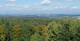
34:(499 m). Behind: the mountains of the Bavarian Forest.
338:
near the village of Altenmarkt in the municipality of
645:
Natural regions of the Upper Palatine-Bavarian Forest
588:
Ulrich Pietrusky, Günther Michler, Donatus Moosauer:
514:
Ulrich Pietrusky, Donatus Moosauer, Günther Michler:
493:
491:
176:
171:
157:
118:
107:
102:
90:
85:
77:
69:
64:
54:
44:
39:
18:
583:150 Jahre Naturwissenschaftlicher Verein Passau
8:
94:
270:. In the north lie the steep slopes of the
585:, 21st year, December 2008, pp. 88−95
15:
592:, Verlag Morsak Grafenau, 2nd edn. 1982,
518:, Verlag Morsak Grafenau, 2. Aufl. 1982,
476:
246:and thus forms a perimeter zone of the
7:
590:Niederbayern – im Fluge neu entdeckt
535:Ulrich Pietrusky, Donatus Moosauer:
30:View of the Neuburg Forest from the
226:. It is named after the village of
448:The Neuburg Forest is composed of
14:
556:Fritsch hiking map, 8th edition:
635:Forests and woodlands of Bavaria
539:, Verlag Morsak Grafenau, 1985,
405:of Haunreut, in Fürstenzell, at
294:, has no special name. Also the
81:186 km (72 sq mi)
24:
604:Haus der Bayerischen Geschichte
394:woods on the county road, the
1:
681:
266:, and in the southeast to
60:499 m (1,637 ft)
23:
321:with the 390-metre-high
206:) is a largely forested
73:16 km (9.9 mi)
242:on the far side of the
203:
95:
425:48.55194°N 13.31528°E
362:48.55278°N 13.34667°E
142:48.55278°N 13.34667°E
579:Der Bayerische Wald
420: /
357: /
222:and the borough of
138: /
640:Regions of Bavaria
575:Der Neuburger Wald
560:, scale 1:100,000.
430:48.55194; 13.31528
367:48.55278; 13.34667
317:(near Seestetten:
147:48.55278; 13.34667
111:west and south of
40:Highest point
650:Passau (district)
581:, Jubiläums-Heft
252:lower Vils valley
218:in the county of
192:
191:
120:Range coordinates
672:
573:Elmar Thumbach:
561:
554:
548:
533:
527:
512:
506:
495:
486:
481:
444:
443:
441:
440:
439:
437:
432:
431:
426:
421:
418:
417:
416:
413:
381:
380:
378:
377:
376:
374:
369:
368:
363:
358:
355:
354:
353:
350:
319:Seestettner Holz
161:
153:
152:
150:
149:
148:
143:
139:
136:
135:
134:
131:
98:
28:
16:
680:
679:
675:
674:
673:
671:
670:
669:
660:Bohemian Massif
625:
624:
570:
565:
564:
555:
551:
534:
530:
513:
509:
496:
489:
482:
478:
473:
435:
433:
429:
427:
423:
422:
419:
414:
411:
409:
407:
406:
372:
370:
366:
364:
360:
359:
356:
351:
348:
346:
344:
343:
248:Bohemian Massif
240:Bavarian Forest
236:
166:Bavarian Forest
159:
146:
144:
140:
137:
132:
129:
127:
125:
124:
35:
12:
11:
5:
678:
676:
668:
667:
662:
657:
652:
647:
642:
637:
627:
626:
623:
622:
620:978-3791722382
600:
586:
569:
566:
563:
562:
549:
528:
507:
487:
475:
474:
472:
469:
307:Neuburg am Inn
284:natural region
268:Neuburg am Inn
235:
232:
228:Neuburg am Inn
212:natural region
204:Neuburger Wald
196:Neuburg Forest
190:
189:
180:
174:
173:
169:
168:
163:
155:
154:
122:
116:
115:
109:
105:
104:
100:
99:
96:Neuburger Wald
92:
88:
87:
83:
82:
79:
75:
74:
71:
67:
66:
62:
61:
58:
52:
51:
46:
42:
41:
37:
36:
29:
21:
20:
19:Neuburg Forest
13:
10:
9:
6:
4:
3:
2:
677:
666:
663:
661:
658:
656:
653:
651:
648:
646:
643:
641:
638:
636:
633:
632:
630:
621:
617:
613:
609:
605:
601:
599:
598:3-87553-135-3
595:
591:
587:
584:
580:
576:
572:
571:
567:
559:
553:
550:
546:
545:3-87553-228-7
542:
538:
532:
529:
525:
524:3-87553-135-3
521:
517:
511:
508:
505:
501:
500:
494:
492:
488:
485:
480:
477:
470:
468:
466:
463:
459:
455:
451:
446:
442:
404:
400:
398:
393:
389:
385:
379:
341:
337:
336:
331:
326:
324:
320:
316:
312:
308:
304:
299:
297:
293:
289:
285:
280:
278:
273:
269:
265:
261:
258:to the lower
257:
253:
249:
245:
241:
233:
231:
229:
225:
221:
217:
216:Lower Bavaria
213:
209:
205:
201:
197:
188:
184:
181:
179:
175:
170:
167:
164:
162:
156:
151:
123:
121:
117:
114:
110:
106:
101:
97:
93:
89:
84:
80:
76:
72:
68:
63:
59:
57:
53:
50:
47:
43:
38:
33:
27:
22:
17:
665:East Bavaria
603:
589:
582:
578:
574:
557:
552:
536:
531:
515:
510:
504:Google Books
498:
479:
447:
395:
391:
383:
333:
329:
327:
323:Hirschenberg
322:
318:
300:
287:
281:
262:valley near
237:
195:
193:
178:Type of rock
160:Parent range
31:
502:, p. 2, at
462:Pleistocene
428: /
397:Kreisstraße
388:water tower
365: /
340:Fürstenzell
303:Fürstenzell
292:Vils valley
145: /
91:Native name
629:Categories
612:3791722387
568:Literature
471:References
434: (
415:13°18′55″E
412:48°33′07″N
371: (
352:13°20′48″E
349:48°33′10″N
288:Hochbuchet
286:is called
208:hill ridge
133:13°20′48″E
130:48°33′10″N
65:Dimensions
401:near the
392:Hochgasse
382:. On the
332:, a flat
315:Vilshofen
311:Löwenwand
272:Löwenwand
256:Vilshofen
234:Geography
103:Geography
56:Elevation
458:Pliocene
454:gneisses
465:gravels
450:granite
296:Alkofen
277:Sauwald
183:granite
172:Geology
655:Passau
618:
610:
596:
577:, in:
543:
522:
436:Platte
403:hamlet
384:Platte
373:Platte
330:Platte
264:Passau
244:Danube
224:Passau
220:Passau
200:German
187:gneiss
113:Passau
86:Naming
70:Length
49:Platte
32:Platte
386:is a
335:kuppe
254:near
108:State
616:ISBN
608:ISBN
594:ISBN
541:ISBN
520:ISBN
460:and
452:and
399:PA11
305:and
210:and
194:The
78:Area
45:Peak
342:at
325:).
260:Inn
214:in
631::
614:,
490:^
467:.
445:.
230:.
202::
185:,
438:)
375:)
198:(
Text is available under the Creative Commons Attribution-ShareAlike License. Additional terms may apply.