30:
1212:
37:
245:, turn south on the West Fork Road and proceed for approximately 14.3 miles. Turn west (right) on Forest Road 468, Nez Perce Road and travel for approximately 16.1 miles" to Nez Perce Pass trailhead." The paved parking area at the pass has a
206:
To the north is the 1.2-million-acre Selway-Bitterroot
Wilderness and to the south the 2.2-million-acre Frank Church-River of No Return Wilderness. These areas comprise over 11% of the Congressionally established
230:(CCC) during the 1930s. It has been known by several names, such as The Southern Nez Perce Trail, The Elk City to Darby Road, The Montana Road, and The Parker Trail." "The landscape is much the same as when the
226:
Forest Road 468, Nez Perce Road, also known as
Magruder Corridor Road, crosses the pass. It is unpaved, and has no services for 117 miles. "The road has changed little since its construction by the
618:
1276:
184:
1271:
1256:
429:"Hamilton, Montana to McCall, Idaho with visits to Nez Perce Pass, Magruder Corridor, Frank Church/River of No Return and Selway-Bitterroot Wildernesses ..."
223:
identifies the Idaho side ... Both Milner and Church helped add thousands of square miles of
Montana and Idaho forest to the nation's wilderness system."
113:
1251:
277:
682:
753:
29:
1241:
796:
1236:
608:
567:
776:
325:
1042:
643:
375:
1012:
665:
1107:
1032:
771:
633:
180:
106:
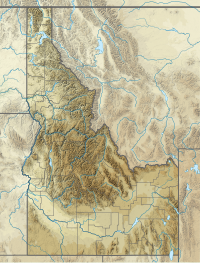
402:
1266:
1197:
1162:
1082:
914:
655:
650:
523:
227:
1157:
1152:
977:
937:
922:
1261:
1187:
1132:
1092:
1027:
786:
677:
613:
1177:
1147:
1127:
1097:
1077:
1002:
997:
992:
957:
927:
628:
1142:
1137:
1122:
1117:
1102:
1072:
1067:
1057:
1052:
1047:
1017:
1007:
967:
952:
829:
78:
1192:
1182:
1112:
1062:
987:
982:
972:
962:
947:
942:
932:
743:
1172:
1167:
560:
1087:
1037:
1022:
844:
160:
95:
884:
879:
733:
703:
698:
670:
261:
74:
53:
348:
1246:
904:
874:
864:
638:
600:
265:
541:
Preliminary
Geologic Map of the Nez Perce Pass 30' x 60' Quadrangle, Southwestern Montana, 1996
889:
849:
839:
814:
809:
804:
257:
216:
819:
708:
553:
540:
495:
231:
899:
894:
869:
859:
834:
781:
761:
590:
208:
145:
99:
1216:
854:
824:
238:
90:
1230:
242:
83:
766:
220:
199:
297:
428:
576:
191:
128:
115:
253:
172:
451:
195:
219:, "graces the Montana side" of the pass. "A sign honoring Idaho Senator
202:," on what is "probably one of the wildest roads in the United States."
738:
728:
723:
718:
713:
660:
623:
580:
246:
168:
545:
524:"Nez Perce Pass USGS Nez Perce Peak Quad, ID, MT, Topographic Map"
164:
475:
176:
549:
376:"Hamilton's Doris Milner honored for wilderness contribution"
496:"Nez Perce Pass Trailhead : Trailhead Information"
326:"Bitterroot National Forest - Nez Perce Pass Trailhead"
320:
318:
343:
341:
179:. The Nez Perce Pass Trailhead offers access to the
913:
795:
752:
691:
599:
397:
395:
144:
105:
89:
70:
62:
52:
18:
194:nearly twice as large as the combined states of
561:
44:Location in Idaho, on the border with Montana
8:
476:"Idaho's Magruder Corridor Wilderness Road"
568:
554:
546:
185:Frank Church—River of No Return Wilderness
15:
1277:Transportation in Ravalli County, Montana
163:on the border between the U.S. states of
302:Montana's Passes and Summits by Bicycle
289:
234:and early travelers crossed the area."
36:
1272:Transportation in Idaho County, Idaho
7:
1257:Landforms of Ravalli County, Montana
452:"National Wilderness Areas in Idaho"
14:
252:Nez Perce Pass marks a change in
1252:Landforms of Idaho County, Idaho
1210:
777:Regional designations of Montana
215:A sign honoring Doris Milner of
35:
28:
374:Lundquist, Laura (2011-06-19).
1:
211:in the 48 contiguous states.
190:The pass is located "between
175:of 6,587 feet (2,008 m)
349:"The Magruder Road Corridor"
181:Selway-Bitterroot Wilderness
228:Civilian Conservation Corps
1293:
1242:Mountain passes of Montana
278:Mountain passes in Montana
241:travel south 4.3 miles on
159:is a mountain pass in the
1206:
619:Congressional delegations
587:
23:
1237:Mountain passes of Idaho
79:Ravalli County, Montana
213:
772:Glacier National Park
403:"Magruder Road Guide"
204:
171:. The pass is at an
161:Bitterroot Mountains
129:45.7167°N 114.5033°W
96:Bitterroot Mountains
683:Tourist attractions
671:The Last Best Place
432:Mountain Mouse Land
150:Nez Perce Peak Quad
125: /
75:Idaho County, Idaho
1267:Borders of Montana
1217:Montana portal
134:45.7167; -114.5033
58:6,587 ft (2,008 m)
1224:
1223:
410:US Forest Service
356:US Forest Service
217:Hamilton, Montana
154:
153:
1284:
1262:Borders of Idaho
1215:
1214:
1213:
570:
563:
556:
547:
537:
535:
534:
510:
509:
507:
506:
492:
486:
485:
483:
482:
472:
466:
465:
463:
462:
448:
442:
441:
439:
438:
425:
419:
418:
417:
416:
407:
399:
390:
389:
387:
386:
380:Ravalli Republic
371:
365:
364:
363:
362:
353:
345:
336:
335:
333:
332:
322:
313:
312:
310:
309:
298:"Nez Perce Pass"
294:
140:
139:
137:
136:
135:
130:
126:
123:
122:
121:
118:
39:
38:
32:
16:
1292:
1291:
1287:
1286:
1285:
1283:
1282:
1281:
1227:
1226:
1225:
1220:
1211:
1209:
1202:
1043:Lewis and Clark
909:
791:
782:Western Montana
762:Eastern Montana
748:
687:
656:Protected areas
595:
583:
574:
532:
530:
522:
519:
514:
513:
504:
502:
494:
493:
489:
480:
478:
474:
473:
469:
460:
458:
450:
449:
445:
436:
434:
427:
426:
422:
414:
412:
405:
401:
400:
393:
384:
382:
373:
372:
368:
360:
358:
351:
347:
346:
339:
330:
328:
324:
323:
316:
307:
305:
296:
295:
291:
286:
274:
209:Wilderness area
177:above sea level
133:
131:
127:
124:
119:
116:
114:
112:
111:
100:Rocky Mountains
98:
82:
48:
47:
46:
45:
42:
41:
40:
12:
11:
5:
1290:
1288:
1280:
1279:
1274:
1269:
1264:
1259:
1254:
1249:
1244:
1239:
1229:
1228:
1222:
1221:
1207:
1204:
1203:
1201:
1200:
1195:
1190:
1185:
1180:
1175:
1170:
1165:
1160:
1155:
1150:
1145:
1140:
1135:
1130:
1125:
1120:
1115:
1110:
1105:
1100:
1095:
1090:
1085:
1080:
1075:
1070:
1065:
1060:
1055:
1050:
1045:
1040:
1035:
1030:
1025:
1020:
1015:
1010:
1005:
1000:
995:
990:
985:
980:
975:
970:
965:
960:
955:
950:
945:
940:
935:
930:
925:
919:
917:
911:
910:
908:
907:
902:
897:
892:
887:
882:
877:
872:
867:
862:
857:
852:
847:
842:
837:
832:
830:Columbia Falls
827:
822:
817:
812:
807:
801:
799:
797:Largest cities
793:
792:
790:
789:
784:
779:
774:
769:
764:
758:
756:
750:
749:
747:
746:
741:
736:
731:
726:
721:
716:
711:
706:
701:
695:
693:
689:
688:
686:
685:
680:
678:Transportation
675:
674:
673:
663:
658:
653:
648:
647:
646:
636:
631:
626:
621:
616:
614:Climate change
611:
605:
603:
597:
596:
588:
585:
584:
575:
573:
572:
565:
558:
550:
544:
543:
538:
518:
517:External links
515:
512:
511:
487:
467:
443:
420:
391:
366:
337:
314:
288:
287:
285:
282:
281:
280:
273:
270:
247:helicopter pad
239:Darby, Montana
157:Nez Perce Pass
152:
151:
148:
142:
141:
109:
103:
102:
93:
87:
86:
72:
68:
67:
64:
60:
59:
56:
50:
49:
43:
34:
33:
27:
26:
25:
24:
21:
20:
19:Nez Perce Pass
13:
10:
9:
6:
4:
3:
2:
1289:
1278:
1275:
1273:
1270:
1268:
1265:
1263:
1260:
1258:
1255:
1253:
1250:
1248:
1245:
1243:
1240:
1238:
1235:
1234:
1232:
1219:
1218:
1205:
1199:
1196:
1194:
1191:
1189:
1186:
1184:
1181:
1179:
1176:
1174:
1171:
1169:
1166:
1164:
1161:
1159:
1156:
1154:
1151:
1149:
1146:
1144:
1141:
1139:
1136:
1134:
1131:
1129:
1126:
1124:
1121:
1119:
1116:
1114:
1111:
1109:
1106:
1104:
1101:
1099:
1096:
1094:
1091:
1089:
1086:
1084:
1081:
1079:
1076:
1074:
1071:
1069:
1066:
1064:
1061:
1059:
1056:
1054:
1051:
1049:
1046:
1044:
1041:
1039:
1036:
1034:
1031:
1029:
1026:
1024:
1021:
1019:
1016:
1014:
1013:Golden Valley
1011:
1009:
1006:
1004:
1001:
999:
996:
994:
991:
989:
986:
984:
981:
979:
976:
974:
971:
969:
966:
964:
961:
959:
956:
954:
951:
949:
946:
944:
941:
939:
936:
934:
931:
929:
926:
924:
921:
920:
918:
916:
912:
906:
903:
901:
898:
896:
893:
891:
888:
886:
883:
881:
878:
876:
873:
871:
868:
866:
863:
861:
858:
856:
853:
851:
848:
846:
843:
841:
838:
836:
833:
831:
828:
826:
823:
821:
818:
816:
813:
811:
808:
806:
803:
802:
800:
798:
794:
788:
785:
783:
780:
778:
775:
773:
770:
768:
765:
763:
760:
759:
757:
755:
751:
745:
742:
740:
737:
735:
732:
730:
727:
725:
722:
720:
717:
715:
712:
710:
707:
705:
702:
700:
697:
696:
694:
690:
684:
681:
679:
676:
672:
669:
668:
667:
666:State symbols
664:
662:
659:
657:
654:
652:
649:
645:
642:
641:
640:
637:
635:
632:
630:
627:
625:
622:
620:
617:
615:
612:
610:
607:
606:
604:
602:
598:
593:
592:
586:
582:
578:
571:
566:
564:
559:
557:
552:
551:
548:
542:
539:
529:
525:
521:
520:
516:
501:
497:
491:
488:
477:
471:
468:
457:
453:
447:
444:
433:
430:
424:
421:
411:
404:
398:
396:
392:
381:
377:
370:
367:
357:
350:
344:
342:
338:
327:
321:
319:
315:
303:
299:
293:
290:
283:
279:
276:
275:
271:
269:
267:
266:Mountain time
263:
259:
255:
250:
248:
244:
240:
235:
233:
229:
224:
222:
218:
212:
210:
203:
201:
197:
193:
188:
186:
182:
178:
174:
170:
166:
162:
158:
149:
147:
143:
138:
110:
108:
104:
101:
97:
94:
92:
88:
85:
84:United States
80:
76:
73:
69:
65:
61:
57:
55:
51:
31:
22:
17:
1208:
1108:Powder River
1033:Judith Basin
767:The Flathead
719:Demographics
644:bibliography
589:
531:. Retrieved
527:
503:. Retrieved
499:
490:
479:. Retrieved
470:
459:. Retrieved
455:
446:
435:. Retrieved
431:
423:
413:, retrieved
409:
383:. Retrieved
379:
369:
359:, retrieved
355:
329:. Retrieved
306:. Retrieved
301:
292:
268:in Montana.
258:Pacific time
251:
236:
225:
221:Frank Church
214:
205:
200:Rhode Island
192:Wildernesses
189:
156:
155:
66:Unpaved road
63:Traversed by
1198:Yellowstone
1163:Sweet Grass
1083:Musselshell
845:Great Falls
787:Yellowstone
744:LGBT rights
456:Sangres.com
132: /
107:Coordinates
1231:Categories
1158:Stillwater
1153:Silver Bow
978:Deer Lodge
938:Broadwater
923:Beaverhead
885:Miles City
880:Livingston
629:Government
533:2013-12-01
505:2013-12-01
500:SummitPost
481:2013-12-01
461:2013-12-01
437:2013-12-01
415:2013-12-01
385:2013-12-01
361:2013-12-01
331:2013-12-01
308:2013-12-01
284:References
243:Highway 93
120:114°30.2′W
1247:Nez Perce
1188:Wheatland
1133:Roosevelt
1093:Petroleum
1028:Jefferson
905:Whitefish
875:Lewistown
865:Kalispell
729:Education
634:Governors
624:Geography
594:(capital)
528:Topo Zone
264:Idaho to
254:time zone
232:Nez Perce
173:elevation
117:45°43.0′N
54:Elevation
1178:Treasure
1148:Sheridan
1128:Richland
1098:Phillips
1078:Missoula
1003:Garfield
998:Gallatin
993:Flathead
958:Chouteau
928:Big Horn
915:Counties
890:Missoula
850:Hamilton
840:Glendive
815:Billings
810:Belgrade
805:Anaconda
739:Politics
734:Gun laws
704:Cannabis
699:Abortion
272:See also
262:northern
196:Delaware
183:and the
146:Topo map
71:Location
1143:Sanders
1138:Rosebud
1123:Ravalli
1118:Prairie
1103:Pondera
1073:Mineral
1068:Meagher
1058:Madison
1053:Lincoln
1048:Liberty
1018:Granite
1008:Glacier
968:Daniels
953:Cascade
820:Bozeman
754:Regions
724:Economy
714:Culture
692:Society
639:History
581:Montana
256:, from
169:Montana
1193:Wibaux
1183:Valley
1113:Powell
1063:McCone
988:Fergus
983:Fallon
973:Dawson
963:Custer
948:Carter
943:Carbon
933:Blaine
900:Sidney
895:Polson
870:Laurel
860:Helena
835:Dillon
661:Sports
651:People
601:Topics
591:Helena
304:. 2012
237:"From
1173:Toole
1168:Teton
855:Havre
825:Butte
709:Crime
609:Index
577:State
406:(PDF)
352:(PDF)
165:Idaho
91:Range
1088:Park
1038:Lake
1023:Hill
198:and
167:and
579:of
260:in
1233::
526:.
498:.
454:.
408:,
394:^
378:.
354:,
340:^
317:^
300:.
249:.
187:.
77:/
569:e
562:t
555:v
536:.
508:.
484:.
464:.
440:.
388:.
334:.
311:.
81:,
Text is available under the Creative Commons Attribution-ShareAlike License. Additional terms may apply.