29:
499:
and 3.7 m) below the
Algonquin high beach. Where the Algonquin divides into several ridges, the Nipissing beach will be one these ridges. In the Superior basin where any considerable width of beach deposits intervenes between the Nipissing and the present shore it is likely to be occupied by rather light beach ridges set very close together, with the Nipissing beach as the uppermost. Where the Algonquin is represented by several ridges, the Algonquin beaches are heavier and less sandy (i.e., pebbly or gravelly) than the Nipissing. Along the east side of the Michigan ‘thumb’ the Nipissing beach has been cut away by the present lake. This is most noticeable along the east side of the "thumb" north of Port Huron, and on both sides of Lake Michigan, and on the east side of Lake Huron.
2794:
45:
468:. A part of the gorge at the whirlpool and a small section above and below it shows a shallow excavation both sides. This shallow excavation was made by a weak waterfall when the Erie basin was the main watershed feeding falls. Near the suspension bridges a deep excavation begins which extends up to the present cataract. This seems to have been created since the flow from Lake Nipissing turned into the St. Clair outlet, feeding water to Lake Erie. The rate of recession the falls would require between 2,700 and 3,500 years to make the deep part of the gorge.
1002:
1870:
2806:
52:
2782:
575:. A fourth stage was initiated when the upper lakes entered the Nipissing Great Lakes stage and that volume of water was diverted through the outlet at North Bay, Ontario. At this low stage, Lake Erie was 10 feet (3.0 m) to 12 feet (3.7 m) lower than present lake level and which lasted throughout the time of the Nipissing Great Lakes.
2770:
597:, which disappeared before the beginning of the Nipissing Great Lakes. It is not certain but that the Champlain Sea had nearly disappeared and all the uplift, except perhaps about 20 feet (6.1 m), had been accomplished. A heavily developed shore line, called the Micmac beach, extends for 200 miles (320 km)below
516:, the Nipissing beaches are sandy ridges 0.5 to 1 mile (0.80 to 1.61 km) from the lakeshore. A mile or two north of Alabaster the cliff back of the beach is 60 to 70 feet (18 to 21 m) high and the bench a quarter of a mile (half kilometer) wide. The beach is a wave-cut bench that carries ridges to the mouth of
471:
Since the opening of the St. Clair outlet there has been continuous flow in the present direction, and the outlet has suffered a slight deepening which has lowered the lake level perhaps 14 feet (4.3 m). The beach at 596 feet (182 m) in the southern end of the Huron basin seems to have been
540:
In the
Michigan and Huron basins the deformed portion of the Nipissing beach appears, as already stated to hinge on the same line as the Algonquin. South of the hinge line in both basins the Nipissing beach has an altitude of 595 feet (181 m)to 597 feet (182 m), the average being about 596
340:
during the stage. The glacier had receded completely from the Great Lakes Basin. The plural form is used to denote that each basin was a separate unit, with a narrow strait connecting each. Each basin stood at the same elevation and thus appear as a single body of water. Lake
Michigan connected to
511:
and
Lakeport has a faint Algonquin beach at its back and a stronger one a mile (2 km) farther west. Outside of these the Nipissing and lower beaches complete the filling of the old bay and bring the shore to a straight line. From Bay City northward to Saginaw, where the hinge line of the Algonquin
498:
beach. South of the line the
Nipissing beaches are horizontal and vary between 14 and 16 feet (4.3 and 4.9 m) above the present lake level, the mean being 15 feet (4.6 m). In the south, the Algonquin beach and the Nipissing beach can be indistinguishable. Both are from 10 and 12 feet (3.0
419:
to the ocean. Mattawa River is a chain of lakes. Some of the lakes are long, narrow, and deep, lying in canyon-like valleys 200 feet (61 m) to 300 feet (91 m)wide, with water 100 feet (30 m) to 300 feet (91 m) deep. The canyons are 100 feet (30 m) or more high. A few places
237:
United States
Geological Survey, George Otis Smith, Director; The Pleistocene of Indiana and Michigan and the History of the Great Lakes; Frank Leverett and Frank B. Taylor; Department of the Interior, Monographs of the United States Geological Survey; Volume LIII; Washington; Government Printing
459:
The low water beaches were submerged through most of their range as the land rebounded. Thus, the known beaches of the
Nipissing Great Lake are those formed during the period that the St. Clair valley served as the outlet. Only a few of the older beaches survive. Lake Nipissing, like
315:
as water levels increased. Levels returned and Lake
Chippewa again flowed through the canyon at Mackinac until around 7,500 YBP. At that time, the waters in the Michigan basin, Huron basin, and the Superior basin created a single lake encompassing all three of the upper
709:
The
Pleistocene of Indiana and Michigan, History of the Great Lakes; Chapter XXII, The Nipissing Great Lakes, Frank B. Taylor; Monographs of the United States Geological Survey, Vol LIII; Frank Leverett and Frank B. Taylor; Washington, D.C,; Government Printing Office;
489:
elevated the region. This lowered the water plane on the north side of the basin and raised it on the south side. Thus the beach from the earlier stage of the
Nipissing Great Lakes in the south was flooded and destroyed. Only the area in the northeast corner of
472:
occupied by Lake Nipissing as well as by the late stage of Lake Algonquin, so the lowering of the lake is from that height to the present. The present beach is 582 feet (177 m) to 584 feet (178 m) with a mean stage of water about 580 feet (180 m).
480:
The name "Nipissing beach" has from the first been applied to the shoreline formed during the two-outlet stage of the lakes. The name more precisely belongs to the older beach made by the Nipissing Great Lakes when the whole discharge passed through the
451:. The basin there is only 8 feet (2.4 m) and the Nipissing beach is 15 feet (4.6 m) above the modern lake. The small discharge would have ended when the outlet at Port Huron had cut down 3 feet (0.91 m) or 4 feet (1.2 m).
664:
Publication 9. Geological Series 7; Surface Geology and Agricultural Conditions of the Southern Peninsula of Michigan; Frank Leverett with a Chapter on Climate by C. F. Schneider;Michigan Geological and Biological Survey Lansing Michigan;
556:
During the time of the Nipissing Great Lakes Lake St. Clair was at low stage; in fact, it was almost if not wholly abandoned as a lake. Only a sluggish, relatively small stream with locally expanded ponds or swampy parts remained.
28:
571:
would lack the volume of water needed to cut the channel through the Niagara limestone cap rock. Lake Erie was a nonglacial lake in this period. The third stage of nonglacial development ended the
609:
and is horizontal. Wave action at this level was evidently powerful and prolonged, for the sea cliff is in places 100 feet (30 m)high, cut in shale, and the wave-cut bench is unusually wide.
1906:
1210:
44:
1656:
494:
still retains remnants of this first or original Nipissing beach. The point of elevation or the ‘hinge line’ for Nipissing beach is the same as the highest
2846:
1650:
2831:
532:
it is a low, broad ridge of sand and gravel a half a mile to a mile wide. From East Tawas it lies generally about a mile (1.5 km) back from the shore.
1899:
97:
1001:
751:
Goldthwait, J. W., The 20 feet (6.1 m) terrace and sea cliff of the lower St. Lawrence: Bull. Geol. Soc. America, vol. 22, 1911. pp. 723-724
399:
The North Bay outlet river, (580 feet (180 m) above sea level) or " Nipissing-Mattawa River," crossed an area of crystalline rock, chiefly
321:
1584:
1560:
1548:
1203:
567:
Lake Erie was at low stage during the time of the Nipissing Great Lakes. Without the inflow from the upper lake basin, both Lake Erie and
1892:
1590:
784:
1830:
1820:
2851:
1523:
1196:
1517:
733:
Taylor, F. B., The Nipissing-Mattawa River, the outlet of the Nipissing Great Lakes: Am. Geologist, Vol. 20, 1897, pp. 65-66
2115:
1136:
2836:
2544:
1251:
1614:
325:
2617:
2607:
1985:
1954:
1760:
1487:
833:
2841:
2754:
2738:
2703:
1825:
1481:
1256:
1018:
911:
602:
529:
1780:
1572:
1511:
724:
Summary of Surface Geology of Michigan: Fred C. Lane; Geological Survey of the State of Michigan, 1908, pg 136
2208:
300:
2366:
1529:
1024:
873:
2728:
2455:
2450:
1662:
1566:
1505:
1493:
1291:
1178:
1049:
933:
865:
777:
420:
along this route show a scoured bed that would require a similar volume and velocity of water movement as
349:
to Huron basin. The outlet of the lakes, however, was eastward from the northeast angle of Georgian Bay.
2708:
2693:
2524:
2420:
2415:
2303:
2293:
2239:
2213:
1805:
1740:
1638:
1416:
1370:
1231:
1141:
986:
959:
889:
806:
801:
742:
Detailed information on the Mattawa River and its lakes is in the report of R. W. Ells and A. E. Barlow
586:
585:
The Lake Algonquin period of lake development included drainage through the Algonquin River to Trenton,
308:
155:
134:
2361:
1815:
1770:
1608:
1286:
1241:
1236:
869:
861:
842:
606:
525:
521:
508:
370:
272:
148:
2650:
1765:
1554:
1465:
1161:
1095:
1076:
1072:
1043:
951:
877:
838:
828:
346:
342:
594:
1845:
1840:
1775:
1114:
416:
362:
345:, except the water was 50 feet (15 m) higher. There was also a narrower, shallower channel
141:
2218:
1884:
1329:
857:
601:
along the south side of the lower St. Lawrence. It is strong and continuous between Quebec and
2688:
2436:
1933:
1873:
1850:
1745:
1431:
1319:
925:
917:
899:
885:
881:
770:
486:
284:
2774:
2529:
2474:
2425:
2410:
1380:
1087:
955:
907:
903:
412:
358:
2627:
2322:
2269:
2198:
2013:
1918:
1719:
1688:
1620:
1602:
1360:
1339:
1261:
1246:
947:
939:
895:
421:
288:
248:
2786:
2539:
2534:
2382:
2371:
2351:
2346:
2279:
2254:
2203:
2167:
2162:
2070:
2023:
1855:
1724:
1683:
1151:
1146:
1131:
1064:
590:
572:
550:
495:
461:
444:
366:
268:
173:
291:, at one stage it had two stable outlets (north and south) both draining to the east.
2825:
2810:
2640:
2602:
2572:
2567:
2445:
2405:
2400:
2390:
2356:
2327:
2183:
2157:
2065:
2060:
2018:
1835:
1800:
1632:
1626:
1596:
1578:
1499:
1441:
1390:
1375:
1334:
943:
929:
921:
850:
579:
568:
491:
465:
404:
382:
304:
264:
252:
166:
73:
443:
In the early part of this closing two-outlet stage a small discharge went by way of
2805:
2798:
2713:
2645:
2635:
2508:
2494:
2288:
2249:
2244:
2178:
2134:
2105:
2100:
2091:
2008:
1975:
1970:
1938:
1785:
1750:
1271:
1266:
1156:
618:
482:
408:
378:
312:
280:
276:
260:
162:
541:
feet (182 m). The altitude of Lake Huron is taken as 581 feet (177 m).
2698:
2612:
2597:
2577:
2503:
2484:
2395:
2337:
2313:
2259:
2228:
2223:
2193:
2173:
2149:
2139:
2110:
1915:
1810:
1795:
1790:
1644:
1436:
1324:
1281:
1106:
846:
623:
517:
513:
337:
317:
83:
33:
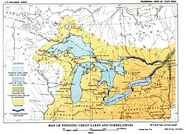
Map of Nipissing Great Lakes from the U.S. Geological Survey monograph of 1915.
2733:
2592:
2587:
2582:
2559:
2549:
2479:
2465:
2298:
2264:
2028:
1714:
1693:
1426:
1385:
1276:
1060:
823:
815:
256:
336:
The term "Nipissing Great Lakes" is applied to the waters of the upper three
112:
99:
2668:
2188:
2125:
2044:
1035:
1010:
978:
561:
373:
outlet began to again receive water, creating a temporary two-outlet lake.
1188:
1980:
1698:
1406:
970:
1755:
1365:
1355:
1166:
974:
793:
448:
142:
156:
2660:
598:
400:
369:. As the ground continued to rebound from the weight of glacier, the
287:
raising the outlet over time, until it opened the outlet through the
2723:
1411:
1314:
2718:
1421:
129:
1888:
1192:
766:
762:
464:, is reflected in the character of the channel in the
299:
The Lake formed from the aggregation of Glacial Lakes
217:
595 mi (958 km) to 597 mi (961 km)
209:
200 mi (320 km) to 300 mi (480 km)
605:. It is 20 feet (6.1 m) above the level of the
271:(YBP). The lake occupied the depression left by the
2747:
2681:
2659:
2626:
2558:
2517:
2493:
2464:
2434:
2380:
2336:
2312:
2278:
2148:
2124:
2090:
2083:
2053:
2037:
2001:
1994:
1963:
1947:
1926:
1733:
1707:
1676:
1539:
1474:
1458:
1399:
1348:
1307:
1300:
1224:
1124:
1105:
1086:
1059:
1034:
1009:
969:
814:
800:
642:
University of Wisconsin, Green Bay, Dept of Geology
485:. After the formation of the true Nipissing beach
233:
229:
221:
213:
205:
197:
193:
185:
172:
154:
140:
128:
89:
79:
69:
21:
512:and Nipissing beaches crosses the west shore of
90:
705:
703:
701:
699:
697:
695:
693:
691:
1657:Withrow Moraine and Jameson Lake Drumlin Field
689:
687:
685:
683:
681:
679:
677:
675:
673:
671:
660:
658:
656:
654:
652:
650:
648:
1900:
1204:
778:
51:
8:
1651:Two Creeks Buried Forest State Natural Area
275:. This body of water drained eastward from
2087:
1998:
1907:
1893:
1885:
1471:
1396:
1304:
1211:
1197:
1189:
811:
785:
771:
763:
18:
635:
1585:Ice Age Floods National Geologic Trail
1549:Chippewa Moraine State Recreation Area
720:
718:
716:
320:. The lowlands through the rapids of
7:
1591:Ice Age National Scientific Reserve
251:. Parts of the former lake are now
2847:Glacial lakes of the United States
14:
2832:Former lakes of the United States
1579:Horicon Marsh State Wildlife Area
2804:
2792:
2780:
2768:
1869:
1868:
1524:Origin of the Oak Ridges Moraine
1000:
50:
43:
27:
267:. It formed about 7,500 years
220:
212:
204:
196:
1587:, Idaho, Oregon and Washington
1:
2116:Proglacial lakes of Minnesota
1831:Huelmo–Mascardi Cold Reversal
1137:Greenhouse and icehouse Earth
68:
1252:Glacial history of Minnesota
428:2nd Detroit & Port Huron
1615:Kettle Moraine State Forest
1518:Lion's Head Provincial Park
328:were open bodies of water.
326:Upper Peninsula of Michigan
16:Prehistoric proglacial lake
2868:
1986:West Siberian Glacial Lake
1761:Penultimate Glacial Period
1488:Big Rock (glacial erratic)
834:Penultimate Glacial Period
189:7,500 years before present
2763:
2755:List of prehistoric lakes
2739:Great Tehuelche Paleolake
1864:
1826:Late Glacial Interstadial
1605:, Minnesota and Wisconsin
1482:Arrowhead Provincial Park
1257:List of prehistoric lakes
1175:
998:
225:580 mi (930 km)
201:241 mi (388 km)
38:
26:
1781:Holocene glacial retreat
1573:Glacial Lakes State Park
1512:Foothills Erratics Train
2852:Glacial lakes of Canada
2209:Lake Houghton (glacial)
1821:Bølling–Allerød warming
1561:Devil's Lake State Park
1530:Ovayok Territorial Park
1219:Continental glaciations
1025:Late Paleozoic icehouse
283:. This was a period of
2451:Kankakee Outwash Plain
2367:Glacial Lake Sammamish
1663:Yosemite National Park
1567:Glacial Lake Wisconsin
1506:Eskers Provincial Park
1494:Cypress Hills (Canada)
1292:Timeline of glaciation
1179:Timeline of glaciation
1046:(579.88 to 579.63 Mya)
507:A shallow bay between
2416:Lake Jordan (Montana)
2304:Glacial Lake Missoula
2294:Glacial Lake Columbia
2234:Nipissing Great Lakes
2214:Glacial Lake Iroquois
1806:Quaternary glaciation
1741:Quaternary glaciation
1639:Mill Bluff State Park
1603:Interstate State Park
1417:Giant current ripples
1232:Cordilleran ice sheet
1142:Great Oxidation Event
245:Nipissing Great Lakes
58:Nipissing Great Lakes
22:Nipissing Great Lakes
2775:Geography portal
2545:Lake Nantucket Sound
2362:Glacial Lake Russell
1816:Wisconsin glaciation
1771:Last Glacial Maximum
1287:Post-glacial rebound
1242:Last Glacial Maximum
1237:Laurentide ice sheet
1027:(360 Mya to 260 Mya)
1021:(460 Mya to 430 Mya)
843:Last Glacial Maximum
607:Gulf of St. Lawrence
603:Ste. Anne de Beaupre
415:, which led out the
149:Laurentide Ice Sheet
2837:Geology of Michigan
1801:Pre-Illinoian Stage
1766:Last Glacial Period
1555:Coteau des Prairies
1466:Greenland ice sheet
1162:Milankovitch cycles
839:Last Glacial Period
407:, which joined the
347:Little Traverse Bay
273:Labradorian Glacier
109: /
2787:History portal
2240:Early Lake Ontario
1846:4.2 kiloyear event
1841:8.2 kiloyear event
1776:Mousterian Pluvial
1508:, British Columbia
1075:(717 to 660 Mya);
1052:(547 to 541.5 Mya)
363:North Bay, Ontario
341:Lake Huron by the
247:was a prehistoric
2819:
2818:
2811:Oceans portal
2677:
2676:
2347:Glacial Lake Hood
2236:(Multiple basins)
2170:(Multiple basins)
2079:
2078:
1934:Lake Makgadikgadi
1882:
1881:
1851:Piora Oscillation
1811:Sangamonian Stage
1672:
1671:
1454:
1453:
1450:
1449:
1186:
1185:
1117:(2.9 to 2.78 Gya)
996:
995:
487:isostatic rebound
332:Location and area
285:isostatic rebound
242:
241:
222:Surface elevation
2859:
2842:Proglacial lakes
2809:
2808:
2799:Lakes portal
2797:
2796:
2795:
2785:
2784:
2783:
2773:
2772:
2771:
2651:Lake San Agustín
2530:Lake Connecticut
2475:Lake Monongahela
2426:Lake Musselshell
2411:Lake Great Falls
2088:
1999:
1921:and related seas
1919:proglacial lakes
1909:
1902:
1895:
1886:
1872:
1871:
1472:
1397:
1381:Terminal moraine
1305:
1213:
1206:
1199:
1190:
1098:(2.4 to 2.1 Gya)
1088:Paleoproterozoic
1079:(650 to 635 Mya)
1004:
812:
787:
780:
773:
764:
752:
749:
743:
740:
734:
731:
725:
722:
711:
707:
666:
662:
643:
640:
440:
439:
435:
396:
395:
391:
359:North Bay Outlet
322:Sault Ste. Marie
289:St. Clair valley
158:
157:Primary outflows
144:
124:
123:
121:
120:
119:
114:
110:
107:
106:
105:
102:
92:
54:
53:
47:
31:
19:
2867:
2866:
2862:
2861:
2860:
2858:
2857:
2856:
2822:
2821:
2820:
2815:
2803:
2793:
2791:
2781:
2779:
2769:
2767:
2759:
2743:
2673:
2655:
2628:Rio Grande rift
2622:
2554:
2513:
2489:
2460:
2430:
2376:
2332:
2323:Lake Bonneville
2308:
2274:
2270:Lake Whittlesey
2199:Early Lake Erie
2144:
2120:
2075:
2049:
2033:
2014:Baltic Ice Lake
1990:
1959:
1943:
1922:
1913:
1883:
1878:
1860:
1746:Illinoian Stage
1729:
1720:Lambert Glacier
1703:
1689:Killary Harbour
1668:
1621:Lake Bonneville
1541:
1535:
1470:
1446:
1395:
1344:
1340:U-shaped valley
1330:Roche moutonnée
1296:
1262:Proglacial lake
1247:Canadian Shield
1220:
1217:
1187:
1182:
1171:
1120:
1101:
1082:
1055:
1030:
1005:
992:
989:(34 to 2.5 Mya)
977:
973:
965:
805:
796:
791:
761:
756:
755:
750:
746:
741:
737:
732:
728:
723:
714:
708:
669:
663:
646:
641:
637:
632:
615:
583:
565:
554:
547:
538:
505:
478:
476:Nipissing Beach
457:
441:
437:
433:
431:
430:
422:St. Clair River
403:, reaching the
397:
393:
389:
387:
386:
355:
343:Mackinac strait
334:
324:and across the
297:
249:proglacial lake
180:
176: countries
143:Primary inflows
117:
115:
111:
108:
103:
100:
98:
96:
95:
65:
64:
63:
62:
61:
60:
59:
55:
34:
17:
12:
11:
5:
2865:
2863:
2855:
2854:
2849:
2844:
2839:
2834:
2824:
2823:
2817:
2816:
2814:
2813:
2801:
2789:
2777:
2764:
2761:
2760:
2758:
2757:
2751:
2749:
2745:
2744:
2742:
2741:
2736:
2731:
2726:
2721:
2716:
2711:
2706:
2701:
2696:
2691:
2689:Lake Ballivián
2685:
2683:
2679:
2678:
2675:
2674:
2672:
2671:
2665:
2663:
2657:
2656:
2654:
2653:
2648:
2643:
2638:
2632:
2630:
2624:
2623:
2621:
2620:
2615:
2610:
2605:
2600:
2595:
2590:
2585:
2580:
2575:
2570:
2564:
2562:
2556:
2555:
2553:
2552:
2547:
2542:
2540:Lake Merrimack
2537:
2535:Lake Hitchcock
2532:
2527:
2521:
2519:
2515:
2514:
2512:
2511:
2506:
2500:
2498:
2491:
2490:
2488:
2487:
2482:
2477:
2471:
2469:
2462:
2461:
2459:
2458:
2456:Lake Wisconsin
2453:
2448:
2442:
2440:
2432:
2431:
2429:
2428:
2423:
2418:
2413:
2408:
2403:
2398:
2393:
2387:
2385:
2383:Missouri River
2378:
2377:
2375:
2374:
2372:Lake Skokomish
2369:
2364:
2359:
2354:
2352:Lake Nisqually
2349:
2343:
2341:
2334:
2333:
2331:
2330:
2325:
2319:
2317:
2310:
2309:
2307:
2306:
2301:
2296:
2291:
2285:
2283:
2280:Columbia River
2276:
2275:
2273:
2272:
2267:
2262:
2257:
2255:Lake Tonawanda
2252:
2247:
2242:
2237:
2231:
2226:
2221:
2216:
2211:
2206:
2204:Lake Frontenac
2201:
2196:
2191:
2186:
2181:
2176:
2171:
2168:Lake Algonquin
2165:
2163:Lake Admiralty
2160:
2154:
2152:
2146:
2145:
2143:
2142:
2137:
2131:
2129:
2122:
2121:
2119:
2118:
2113:
2108:
2103:
2097:
2095:
2085:
2081:
2080:
2077:
2076:
2074:
2073:
2071:Lake Pickering
2068:
2063:
2057:
2055:
2051:
2050:
2048:
2047:
2041:
2039:
2035:
2034:
2032:
2031:
2026:
2024:Mastogloia Sea
2021:
2016:
2011:
2005:
2003:
1996:
1992:
1991:
1989:
1988:
1983:
1978:
1973:
1967:
1965:
1961:
1960:
1958:
1957:
1951:
1949:
1945:
1944:
1942:
1941:
1936:
1930:
1928:
1924:
1923:
1914:
1912:
1911:
1904:
1897:
1889:
1880:
1879:
1877:
1876:
1865:
1862:
1861:
1859:
1858:
1856:Little Ice Age
1853:
1848:
1843:
1838:
1833:
1828:
1823:
1818:
1813:
1808:
1803:
1798:
1793:
1788:
1783:
1778:
1773:
1768:
1763:
1758:
1753:
1748:
1743:
1737:
1735:
1731:
1730:
1728:
1727:
1725:Ross Ice Shelf
1722:
1717:
1711:
1709:
1705:
1704:
1702:
1701:
1696:
1691:
1686:
1684:Hardangerfjord
1680:
1678:
1674:
1673:
1670:
1669:
1667:
1666:
1660:
1654:
1648:
1642:
1636:
1630:
1624:
1618:
1612:
1609:Kelleys Island
1606:
1600:
1594:
1588:
1582:
1576:
1570:
1564:
1558:
1557:, South Dakota
1552:
1545:
1543:
1537:
1536:
1534:
1533:
1527:
1521:
1515:
1509:
1503:
1497:
1496:, Saskatchewan
1491:
1485:
1478:
1476:
1469:
1468:
1462:
1460:
1456:
1455:
1452:
1451:
1448:
1447:
1445:
1444:
1439:
1434:
1429:
1424:
1419:
1414:
1409:
1403:
1401:
1394:
1393:
1388:
1383:
1378:
1373:
1368:
1363:
1358:
1352:
1350:
1346:
1345:
1343:
1342:
1337:
1332:
1327:
1322:
1320:Glacial striae
1317:
1311:
1309:
1302:
1298:
1297:
1295:
1294:
1289:
1284:
1279:
1274:
1269:
1264:
1259:
1254:
1249:
1244:
1239:
1234:
1228:
1226:
1222:
1221:
1218:
1216:
1215:
1208:
1201:
1193:
1184:
1183:
1176:
1173:
1172:
1170:
1169:
1164:
1159:
1154:
1152:Snowball Earth
1149:
1147:Little Ice Age
1144:
1139:
1134:
1132:Glacial period
1128:
1126:
1125:Related topics
1122:
1121:
1119:
1118:
1111:
1109:
1103:
1102:
1100:
1099:
1092:
1090:
1084:
1083:
1081:
1080:
1069:
1067:
1065:Snowball Earth
1057:
1056:
1054:
1053:
1047:
1040:
1038:
1032:
1031:
1029:
1028:
1022:
1019:Andean-Saharan
1015:
1013:
1007:
1006:
999:
997:
994:
993:
991:
990:
983:
981:
967:
966:
964:
963:
962:(2.5 to 0 Mya)
936:
914:
892:
854:
836:
831:
826:
820:
818:
809:
798:
797:
792:
790:
789:
782:
775:
767:
760:
759:External links
757:
754:
753:
744:
735:
726:
712:
667:
644:
634:
633:
631:
628:
627:
626:
621:
614:
611:
591:Lake Frontenac
582:
577:
573:Lake Algonquin
564:
559:
553:
551:Lake St. Clair
548:
546:
543:
537:
534:
530:Au Sable River
528:and beyond to
504:
503:Beach remnants
501:
477:
474:
462:Lake Algonquin
456:
453:
445:Illinois River
429:
426:
385:
375:
367:Lake Nipissing
354:
351:
333:
330:
296:
293:
269:before present
240:
239:
235:
231:
230:
227:
226:
223:
219:
218:
215:
211:
210:
207:
203:
202:
199:
195:
194:
191:
190:
187:
183:
182:
177:
170:
169:
160:
152:
151:
146:
138:
137:
132:
126:
125:
113:45.8°N 84.72°W
93:
87:
86:
81:
77:
76:
71:
67:
66:
57:
56:
49:
48:
42:
41:
40:
39:
36:
35:
32:
24:
23:
15:
13:
10:
9:
6:
4:
3:
2:
2864:
2853:
2850:
2848:
2845:
2843:
2840:
2838:
2835:
2833:
2830:
2829:
2827:
2812:
2807:
2802:
2800:
2790:
2788:
2778:
2776:
2766:
2765:
2762:
2756:
2753:
2752:
2750:
2746:
2740:
2737:
2735:
2732:
2730:
2727:
2725:
2722:
2720:
2717:
2715:
2712:
2710:
2707:
2705:
2702:
2700:
2697:
2695:
2692:
2690:
2687:
2686:
2684:
2682:South America
2680:
2670:
2667:
2666:
2664:
2662:
2658:
2652:
2649:
2647:
2644:
2642:
2641:Lake Estancia
2639:
2637:
2634:
2633:
2631:
2629:
2625:
2619:
2618:Lake Thompson
2616:
2614:
2611:
2609:
2606:
2604:
2603:Lake Panamint
2601:
2599:
2596:
2594:
2591:
2589:
2586:
2584:
2581:
2579:
2576:
2574:
2573:Lake Corcoran
2571:
2569:
2568:Lake Cahuilla
2566:
2565:
2563:
2561:
2557:
2551:
2548:
2546:
2543:
2541:
2538:
2536:
2533:
2531:
2528:
2526:
2525:Lake Cape Cod
2523:
2522:
2520:
2516:
2510:
2507:
2505:
2502:
2501:
2499:
2496:
2492:
2486:
2483:
2481:
2478:
2476:
2473:
2472:
2470:
2467:
2463:
2457:
2454:
2452:
2449:
2447:
2446:Lake Kankakee
2444:
2443:
2441:
2438:
2433:
2427:
2424:
2422:
2421:Lake McKenzie
2419:
2417:
2414:
2412:
2409:
2407:
2406:Lake Glendive
2404:
2402:
2401:Lake Cut Bank
2399:
2397:
2394:
2392:
2391:Lake Chouteau
2389:
2388:
2386:
2384:
2379:
2373:
2370:
2368:
2365:
2363:
2360:
2358:
2357:Lake Puyallup
2355:
2353:
2350:
2348:
2345:
2344:
2342:
2339:
2335:
2329:
2328:Lake Lahontan
2326:
2324:
2321:
2320:
2318:
2315:
2311:
2305:
2302:
2300:
2297:
2295:
2292:
2290:
2287:
2286:
2284:
2281:
2277:
2271:
2268:
2266:
2263:
2261:
2258:
2256:
2253:
2251:
2248:
2246:
2243:
2241:
2238:
2235:
2232:
2230:
2227:
2225:
2222:
2220:
2217:
2215:
2212:
2210:
2207:
2205:
2202:
2200:
2197:
2195:
2192:
2190:
2187:
2185:
2184:Lake Chippewa
2182:
2180:
2177:
2175:
2172:
2169:
2166:
2164:
2161:
2159:
2158:Champlain Sea
2156:
2155:
2153:
2151:
2147:
2141:
2138:
2136:
2133:
2132:
2130:
2127:
2123:
2117:
2114:
2112:
2109:
2107:
2104:
2102:
2099:
2098:
2096:
2093:
2089:
2086:
2084:North America
2082:
2072:
2069:
2067:
2066:Lake Lapworth
2064:
2062:
2061:Lake Harrison
2059:
2058:
2056:
2054:Great Britain
2052:
2046:
2043:
2042:
2040:
2036:
2030:
2027:
2025:
2022:
2020:
2019:Littorina Sea
2017:
2015:
2012:
2010:
2007:
2006:
2004:
2000:
1997:
1993:
1987:
1984:
1982:
1979:
1977:
1974:
1972:
1969:
1968:
1966:
1962:
1956:
1955:Lake Washburn
1953:
1952:
1950:
1946:
1940:
1937:
1935:
1932:
1931:
1929:
1925:
1920:
1917:
1910:
1905:
1903:
1898:
1896:
1891:
1890:
1887:
1875:
1867:
1866:
1863:
1857:
1854:
1852:
1849:
1847:
1844:
1842:
1839:
1837:
1836:Younger Dryas
1834:
1832:
1829:
1827:
1824:
1822:
1819:
1817:
1814:
1812:
1809:
1807:
1804:
1802:
1799:
1797:
1794:
1792:
1789:
1787:
1784:
1782:
1779:
1777:
1774:
1772:
1769:
1767:
1764:
1762:
1759:
1757:
1754:
1752:
1749:
1747:
1744:
1742:
1739:
1738:
1736:
1732:
1726:
1723:
1721:
1718:
1716:
1713:
1712:
1710:
1706:
1700:
1697:
1695:
1692:
1690:
1687:
1685:
1682:
1681:
1679:
1675:
1664:
1661:
1658:
1655:
1652:
1649:
1646:
1643:
1640:
1637:
1634:
1633:Lake Missoula
1631:
1628:
1627:Lake Lahontan
1625:
1622:
1619:
1616:
1613:
1610:
1607:
1604:
1601:
1598:
1597:Ice Age Trail
1595:
1592:
1589:
1586:
1583:
1580:
1577:
1574:
1571:
1568:
1565:
1562:
1559:
1556:
1553:
1550:
1547:
1546:
1544:
1538:
1531:
1528:
1525:
1522:
1519:
1516:
1513:
1510:
1507:
1504:
1501:
1500:Eramosa River
1498:
1495:
1492:
1489:
1486:
1483:
1480:
1479:
1477:
1473:
1467:
1464:
1463:
1461:
1459:North America
1457:
1443:
1440:
1438:
1435:
1433:
1430:
1428:
1425:
1423:
1420:
1418:
1415:
1413:
1410:
1408:
1405:
1404:
1402:
1398:
1392:
1391:Veiki moraine
1389:
1387:
1384:
1382:
1379:
1377:
1376:Rogen moraine
1374:
1372:
1371:Pulju moraine
1369:
1367:
1364:
1362:
1361:Erratic block
1359:
1357:
1354:
1353:
1351:
1347:
1341:
1338:
1336:
1335:Tunnel valley
1333:
1331:
1328:
1326:
1323:
1321:
1318:
1316:
1313:
1312:
1310:
1306:
1303:
1299:
1293:
1290:
1288:
1285:
1283:
1280:
1278:
1275:
1273:
1270:
1268:
1265:
1263:
1260:
1258:
1255:
1253:
1250:
1248:
1245:
1243:
1240:
1238:
1235:
1233:
1230:
1229:
1227:
1223:
1214:
1209:
1207:
1202:
1200:
1195:
1194:
1191:
1181:
1180:
1174:
1168:
1165:
1163:
1160:
1158:
1155:
1153:
1150:
1148:
1145:
1143:
1140:
1138:
1135:
1133:
1130:
1129:
1127:
1123:
1116:
1113:
1112:
1110:
1108:
1104:
1097:
1094:
1093:
1091:
1089:
1085:
1078:
1074:
1071:
1070:
1068:
1066:
1062:
1058:
1051:
1048:
1045:
1042:
1041:
1039:
1037:
1033:
1026:
1023:
1020:
1017:
1016:
1014:
1012:
1008:
1003:
988:
985:
984:
982:
980:
976:
972:
968:
961:
957:
953:
949:
945:
944:Pre-Illinoian
941:
937:
935:
931:
927:
923:
922:Pre-Illinoian
919:
915:
913:
909:
905:
901:
897:
893:
891:
887:
883:
879:
875:
871:
867:
863:
859:
855:
852:
851:Younger Dryas
848:
844:
840:
837:
835:
832:
830:
827:
825:
822:
821:
819:
817:
813:
810:
808:
807:Late Cenozoic
803:
799:
795:
788:
783:
781:
776:
774:
769:
768:
765:
758:
748:
745:
739:
736:
730:
727:
721:
719:
717:
713:
706:
704:
702:
700:
698:
696:
694:
692:
690:
688:
686:
684:
682:
680:
678:
676:
674:
672:
668:
661:
659:
657:
655:
653:
651:
649:
645:
639:
636:
629:
625:
622:
620:
617:
616:
612:
610:
608:
604:
600:
596:
592:
588:
587:Lake Iroquois
581:
580:Champlain Sea
578:
576:
574:
570:
569:Niagara Falls
563:
560:
558:
552:
549:
544:
542:
535:
533:
531:
527:
523:
519:
515:
510:
502:
500:
497:
493:
492:Lake Superior
488:
484:
475:
473:
469:
467:
466:Niagara Gorge
463:
454:
452:
450:
446:
436:
427:
425:
423:
418:
417:St. Lawrence
414:
410:
406:
405:Mattawa River
402:
392:
384:
383:Mattawa River
380:
376:
374:
372:
368:
365:, the modern
364:
360:
352:
350:
348:
344:
339:
331:
329:
327:
323:
319:
314:
310:
306:
302:
294:
292:
290:
286:
282:
281:Ottawa valley
278:
274:
270:
266:
265:Lake Michigan
262:
258:
254:
253:Lake Superior
250:
246:
236:
232:
228:
224:
216:
208:
200:
192:
188:
186:First flooded
184:
181:United States
178:
175:
171:
168:
167:Mattawa River
164:
161:
159:
153:
150:
147:
145:
139:
136:
133:
131:
127:
122:
94:
88:
85:
82:
78:
75:
74:North America
72:
46:
37:
30:
25:
20:
2714:Lake Minchin
2646:Lake Palomas
2636:Lake Alamosa
2608:Lake Russell
2509:Lake Passaic
2289:Lake Allison
2250:Lake Stanley
2245:Lake Saginaw
2233:
2179:Lake Chicago
2135:Lake Ojibway
2106:Lake Bassano
2101:Lake Agassiz
2092:Nelson River
2009:Ancylus Lake
1976:Lake Tengger
1971:Lake Bandung
1939:Lake Ptolemy
1786:Oldest Dryas
1756:Interstadial
1751:Interglacial
1734:Time periods
1665:, California
1659:, Washington
1400:Glacifluvial
1349:Depositional
1272:Lake Chicago
1267:Lake Agassiz
1177:
1157:Interglacial
747:
738:
729:
638:
619:Lake Agassiz
595:Gilbert Gulf
584:
566:
555:
545:Correlatives
539:
506:
483:Ottawa River
479:
470:
458:
442:
409:Ottawa River
398:
356:
335:
298:
277:Georgian Bay
261:Georgian Bay
244:
243:
238:Office; 1915
163:Ottawa River
118:45.8; -84.72
2699:Lake Escara
2613:Lake Tecopa
2598:Lake Mojave
2578:Lake Harper
2518:New England
2504:Lake Albany
2485:Teays River
2437:Mississippi
2396:Lake Circle
2338:Puget Sound
2314:Great Basin
2260:Lake Warren
2229:Lake Minong
2224:Lake Maumee
2194:Lake Duluth
2174:Lake Arkona
2150:Great Lakes
2140:Tyrrell Sea
2111:Lake Souris
1916:Pleistocene
1796:Pleistocene
1791:Older Dryas
1653:, Wisconsin
1645:Oneida Lake
1641:, Wisconsin
1617:, Wisconsin
1599:, Wisconsin
1593:, Wisconsin
1581:, Wisconsin
1575:, Minnesota
1569:, Wisconsin
1563:, Wisconsin
1551:, Wisconsin
1437:Outwash fan
1432:Kettle hole
1325:Ribbon lake
1282:Teays River
1107:Mesoarchean
1050:Baykonurian
912:Santa María
866:Weichselian
624:Lake Maumee
518:Tawas River
514:Saginaw Bay
338:Great Lakes
318:Great Lakes
198:Max. length
135:former lake
116: /
91:Coordinates
84:Great Lakes
2826:Categories
2734:Lake Tauca
2704:Inca Huasi
2593:Lake Modoc
2588:Lake Manly
2583:Lake Manix
2560:California
2550:Lake Stowe
2480:Lake Tight
2299:Lake Lewis
2265:Lake Wayne
2219:Lake Lundy
2029:Yoldia Sea
2002:Baltic Sea
1948:Antarctica
1715:Antarctica
1708:Antarctica
1694:Monte Rosa
1647:, New York
1427:Kame delta
1386:Till plain
1277:Lake Tight
1061:Cryogenian
956:Beestonian
908:Wolstonian
890:Llanquihue
874:Midlandian
824:Antarctica
816:Quaternary
802:Quaternary
630:References
526:East Tawas
520:. Through
509:Port Huron
371:Port Huron
257:Lake Huron
234:References
214:Max. depth
206:Max. width
2669:Lake Atna
2189:Lake Dana
2126:James Bay
2045:Lake Komi
1635:, Montana
1532:, Nunavut
1526:, Ontario
1520:, Ontario
1514:, Alberta
1502:, Ontario
1490:, Alberta
1484:, Ontario
1308:Erosional
1301:Landforms
1036:Ediacaran
1011:Paleozoic
987:Antarctic
979:Oligocene
938:7th–8th:
934:Rio Llico
916:3rd–6th:
900:Illinoian
870:Devensian
862:Wisconsin
829:Greenland
562:Lake Erie
496:Algonquin
130:Lake type
2468:drainage
2439:drainage
2128:drainage
2094:drainage
1981:Mundafan
1874:Category
1699:Svalbard
1629:, Nevada
1407:Diluvium
1096:Huronian
1077:Marinoan
1073:Sturtian
1044:Gaskiers
971:Pliocene
952:Menapian
878:Pinedale
794:Ice ages
613:See also
536:Altitude
305:Chippewa
301:Houghton
70:Location
2748:Summary
2729:Salinas
1677:Eurasia
1366:Moraine
1356:Drumlin
1225:General
1167:Stadial
1115:Pongola
975:Miocene
960:Caracol
930:Anglian
455:Beaches
449:Chicago
424:today.
413:Mattawa
361:was at
353:Outlets
313:Stanley
279:to the
165:to the
104:84°43′W
101:45°48′N
2709:Mataro
2694:Cabana
2661:Alaska
2497:valley
2495:Hudson
2435:Upper
2381:Upper
2340:system
2316:system
2282:system
2038:Russia
1995:Europe
1927:Africa
1623:, Utah
1611:, Ohio
1542:States
1540:United
1475:Canada
1442:Sandur
926:Elster
918:Mindel
886:Merida
882:Fraser
599:Quebec
593:, and
432:": -->
401:gneiss
388:": -->
381:&
379:Ottawa
311:, and
295:Origin
179:Canada
2724:Sajsi
1412:Esker
1315:Fjord
904:Saale
894:2nd:
856:1st:
847:Older
522:Tawas
309:Hough
174:Basin
80:Group
2719:Ouki
2466:Ohio
1964:Asia
1422:Kame
948:Elbe
940:Günz
896:Riss
858:Würm
849:and
710:1915
665:1911
524:and
434:edit
390:edit
377:1st
357:The
307:and
263:and
950:or
447:at
411:at
2828::
958:,
954:,
946:,
942:,
932:,
928:,
924:,
920:,
910:,
906:,
902:,
898:,
888:,
884:,
876:,
868:,
864:,
860:,
845:,
804:/
715:^
670:^
647:^
589:,
303:,
259:,
255:,
1908:e
1901:t
1894:v
1212:e
1205:t
1198:v
1063:-
880:/
872:/
853:)
841:(
786:e
779:t
772:v
438:]
394:]
Text is available under the Creative Commons Attribution-ShareAlike License. Additional terms may apply.