56:
202:
40:
229:
217:
63:
190:
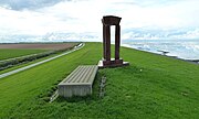
placed in 2002. The name 'Noordkaap' was coined at the same time as the artwork was placed. The spot itself is not easily recognizable as an 'extreme point' because the sea dike has a gentle curve.
339:
249:
201:
157:
55:
84:
39:
259:
228:
254:
216:
344:
176:
127:
186:
had the artwork 'Poort Kaap Noord', colloquially known as 'De
Hemelpoort', (made in 2001) by artist
308:
284:
168:
139:
30:
187:
333:
172:
123:
161:
208:
99:
86:
235:
119:
183:
182:
To mark the spot and attract more tourists, the then municipality of
133:
115:
21:
167:The Noordkaap is located on the north side of the
179:. It is only accessible on foot or by bicycle.
8:
18:
250:List of extreme points of the Netherlands
271:
197:
132:
114:
48:
36:
7:
279:
277:
275:
171:, on the edge of the municipality
14:
340:Geography of Groningen (province)
207:Panorama from the artwork on the
62:
227:
215:
200:
61:
54:
38:
44:De Hemelpoort/Poort Kaap Noord
16:Point in Eemsmond, Netherlands
1:
260:Geography of the Netherlands
361:
80:
49:
37:
28:
255:Extreme points of Earth
100:53.465278°N 6.745556°E
313:www.visitgroningen.nl
177:province of Groningen
234:View looking east (
105:53.465278; 6.745556
96: /
158:northernmost point
222:View looking west
147:
146:
352:
324:
323:
321:
320:
305:
299:
298:
296:
295:
281:
231:
219:
204:
143:
142:
140:Official website
111:
110:
108:
107:
106:
101:
97:
94:
93:
92:
89:
65:
64:
58:
42:
19:
360:
359:
355:
354:
353:
351:
350:
349:
330:
329:
328:
327:
318:
316:
307:
306:
302:
293:
291:
289:Visit Groningen
283:
282:
273:
268:
246:
239:
232:
223:
220:
211:
205:
196:
138:
137:
104:
102:
98:
95:
90:
87:
85:
83:
82:
76:
75:
74:
73:
72:
71:
70:
66:
45:
33:
24:
17:
12:
11:
5:
358:
356:
348:
347:
342:
332:
331:
326:
325:
300:
270:
269:
267:
264:
263:
262:
257:
252:
245:
242:
241:
240:
233:
226:
224:
221:
214:
212:
206:
199:
195:
192:
145:
144:
135:
131:
130:
117:
113:
112:
78:
77:
68:
67:
60:
59:
53:
52:
51:
50:
47:
46:
43:
35:
34:
29:
26:
25:
22:
15:
13:
10:
9:
6:
4:
3:
2:
357:
346:
343:
341:
338:
337:
335:
314:
310:
304:
301:
290:
286:
280:
278:
276:
272:
265:
261:
258:
256:
253:
251:
248:
247:
243:
237:
230:
225:
218:
213:
210:
203:
198:
193:
191:
189:
185:
180:
178:
174:
170:
165:
163:
159:
155:
151:
141:
136:
129:
125:
121:
118:
109:
81:Coordinates:
79:
57:
41:
32:
27:
20:
345:Het Hogeland
317:. Retrieved
312:
309:"Hemelpoort"
303:
292:. Retrieved
288:
188:René de Boer
181:
173:Het Hogeland
166:
160:of mainland
153:
149:
148:
124:Het Hogeland
285:"Noordkaap"
162:Netherlands
103: /
334:Categories
319:2022-12-27
315:(in Dutch)
294:2022-12-27
266:References
209:Wadden Sea
169:Emmapolder
154:North Cape
88:53°27′55″N
236:Eemshaven
156:) is the
150:Noordkaap
128:Groningen
120:Eemshaven
91:6°44′44″E
69:Noordkaap
23:Noordkaap
244:See also
184:Eemsmond
116:Location
194:Gallery
175:in the
134:Website
31:Cape
336::
311:.
287:.
274:^
164:.
126:,
122:,
322:.
297:.
238:)
152:(
Text is available under the Creative Commons Attribution-ShareAlike License. Additional terms may apply.