306:
35:
418:
42:
188:
335:
The village has a row of terrace houses named Low Row consisting of 20 houses. There are also estates called
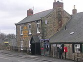
Wellgarth Court, North Bitchburn Terrace and Hillside Court. There is one public house, a Methodist chapel and one shop within the village centre. The public house is named 'The Red Lion'.
380:
387:
228:
205:
73:
212:
236:
459:
488:
34:
200:
478:
272:
364:
305:
254:
264:
172:
136:
100:
483:
452:
66:
217:
329:
259:
445:
150:
165:
82:
193:
126:
118:
360:
177:
321:
429:
325:
417:
472:
425:
317:
108:
90:
55:
287:
274:
160:
142:
304:
320:, England. It is situated 3 miles (4.8 km) north west of
433:
227:
211:
199:
187:
171:
159:
149:
135:
117:
99:
81:
65:
23:
453:
8:
460:
446:
20:
354:Ordnance Survey: Landranger map sheet 92
332:North Bitchburn had a population of 135.
356:Barnard Castle & Richmond (Teesdale)
386:. Durham County Council. Archived from
381:"Wear Valley Settlement Summary Sheets"
345:
226:
182:
158:
134:
64:
41:
210:
198:
186:
170:
148:
116:
98:
80:
7:
414:
412:
14:
416:
40:
33:
309:The Red Lion in North Bitchburn
359:(Map). Ordnance Survey. 2011.
1:
489:County Durham geography stubs
432:. You can help Knowledge by
206:County Durham and Darlington
67:OS grid reference
18:Human settlement in England
505:
411:
479:Villages in County Durham
245:
223:
183:
28:
428:location article is a
316:is a small village in
310:
173:Postcode district
101:Ceremonial county
83:Unitary authority
308:
484:Crook, County Durham
151:Sovereign state
284: /
311:
229:UK Parliament
441:
440:
393:on 7 October 2007
303:
302:
237:North West Durham
496:
462:
455:
448:
420:
413:
403:
402:
400:
398:
392:
385:
377:
371:
370:
350:
299:
298:
296:
295:
294:
289:
288:54.689°N 1.733°W
285:
282:
281:
280:
277:
251:
145:
77:
76:
54:Location within
44:
43:
37:
21:
504:
503:
499:
498:
497:
495:
494:
493:
469:
468:
467:
466:
409:
407:
406:
396:
394:
390:
383:
379:
378:
374:
367:
352:
351:
347:
342:
322:Bishop Auckland
314:North Bitchburn
292:
290:
286:
283:
278:
275:
273:
271:
270:
269:
249:
241:
141:
131:
113:
95:
72:
71:
61:
60:
59:
58:
52:
51:
50:
49:
48:North Bitchburn
45:
24:North Bitchburn
19:
12:
11:
5:
502:
500:
492:
491:
486:
481:
471:
470:
465:
464:
457:
450:
442:
439:
438:
421:
405:
404:
372:
365:
344:
343:
341:
338:
326:Howden-le-Wear
301:
300:
293:54.689; -1.733
268:
267:
262:
257:
252:
250:List of places
246:
243:
242:
240:
239:
233:
231:
225:
224:
221:
220:
215:
209:
208:
203:
197:
196:
191:
185:
184:
181:
180:
175:
169:
168:
163:
157:
156:
155:United Kingdom
153:
147:
146:
139:
133:
132:
130:
129:
123:
121:
115:
114:
112:
111:
105:
103:
97:
96:
94:
93:
87:
85:
79:
78:
69:
63:
62:
53:
47:
46:
39:
38:
32:
31:
30:
29:
26:
25:
17:
13:
10:
9:
6:
4:
3:
2:
501:
490:
487:
485:
482:
480:
477:
476:
474:
463:
458:
456:
451:
449:
444:
443:
437:
435:
431:
427:
426:County Durham
422:
419:
415:
410:
389:
382:
376:
373:
368:
366:9780319228982
362:
358:
355:
349:
346:
339:
337:
333:
331:
327:
323:
319:
318:County Durham
315:
307:
297:
266:
265:County Durham
263:
261:
258:
256:
253:
248:
247:
244:
238:
235:
234:
232:
230:
222:
219:
216:
214:
207:
204:
202:
195:
192:
190:
179:
176:
174:
167:
164:
162:
154:
152:
144:
140:
138:
128:
125:
124:
122:
120:
110:
109:County Durham
107:
106:
104:
102:
92:
91:County Durham
89:
88:
86:
84:
75:
70:
68:
57:
56:County Durham
36:
27:
22:
16:
434:expanding it
423:
408:
395:. Retrieved
388:the original
375:
357:
353:
348:
334:
313:
312:
15:
397:19 February
330:2001 census
291: /
473:Categories
340:References
276:54°41′20″N
218:North East
127:North East
328:. In the
279:1°43′59″W
213:Ambulance
161:Post town
74:NZ172327
324:, near
260:England
143:England
137:Country
363:
194:Durham
189:Police
119:Region
424:This
391:(PDF)
384:(PDF)
166:Crook
430:stub
399:2009
361:ISBN
201:Fire
178:DL15
475::
255:UK
461:e
454:t
447:v
436:.
401:.
369:.
Text is available under the Creative Commons Attribution-ShareAlike License. Additional terms may apply.