693:
705:
741:
717:
240:
729:
116:
25:
255:
66:
614:
Oakeys Brook generally has a clay streambed. Upstream decay products turn the mud black, making it an ideal place for amphibians and turtles to hide in. Downstream, there are a few more rocks, although the stream is still muddy and deep. The stream flows through wetland areas in several places near
618:
This stream is generally low-lying, collecting water from various storm drainage systems. It is fed by swamp drainage and springs in the downstream areas but by storm drainage and farm drainage in upstream areas. Since a major source is storm drainage, it swells considerably during rains.
529:
and merges with another unnamed tributary. It continues flowing away from Black Horse Lane before coming toward it and crossing the railroad tracks a little farther north than the road reaches them. Another unnamed tributary joins it, along with
597:
may be found by the stream. Upstream, numerous species of small fish live in it, providing food for some birds which live there. The deer cross on planks of wood to get food. It is easy for people to cross, but crayfish can snap at your feet
494:. Farther downstream, it runs through the Nassau Square housing development on Augustine Drive. Then it crosses Henderson Road in northern South Brunswick (which is its official source at
606:
Oakeys Brook flows in many areas through developed sectors, where it is easily accessible. Students at
Brunswick Acres are sometimes allowed to pick up the trash littered on the bank.
692:
740:
818:
704:
545:
497:
357:
133:
38:
728:
823:
803:
779:
716:
304:
245:
76:
180:
581:
Oakeys Brook is an ecosystem full of many varieties of life, despite its proximity to human habitation in many upstream areas. Many
217:
199:
152:
97:
52:
159:
137:
44:
828:
660:
166:
757:
640:
471:
628:
531:
491:
148:
655:
650:
126:
173:
239:
525:), and runs beside the Brunswick Acres School in northern South Brunswick. It then crosses
671:
539:
589:
live in the stream, especially upstream where natural dams sometimes create small ponds.
535:
463:
447:
423:
415:
407:
812:
479:
467:
411:
273:
526:
665:
645:
340:
115:
746:
Oakeys Brook flowing through
Brunswick Acres Elementary School in Kendall Park
475:
560:
547:
512:
499:
372:
359:
319:
306:
459:
538:
near Black Horse Lane, and crosses
Davidson Mill Road before emptying into
254:
582:
698:
Oakeys Brook near its source, in the Nassau Square housing development
594:
590:
586:
109:
59:
18:
490:
The source of Oakeys Brook is near
Beekman Road in central
734:
Oakeys Brook near
Brunswick Acres Elementary School
441:
433:
421:
403:
398:
388:
349:
339:
296:
288:
279:
269:
264:
232:
140:. Unsourced material may be challenged and removed.
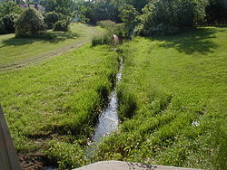
710:Oakeys Brook in Nassau Square a little downstream
8:
244:Oakeys Brook near Brunswick Acres School in
53:Learn how and when to remove these messages
253:
16:Tributary of a branch of the Raritan River
218:Learn how and when to remove this message
200:Learn how and when to remove this message
98:Learn how and when to remove this message
768:
688:
819:Rivers of Middlesex County, New Jersey
774:
772:
680:Unnamed Brook in Rutgers' Helyar Woods
229:
7:
722:Oakeys Brook crossing Henderson Road
138:adding citations to reliable sources
82:Please help consolidate the article.
14:
34:This article has multiple issues.
824:Tributaries of the Raritan River
739:
727:
715:
703:
691:
238:
114:
64:
23:
804:USGS Coordinates in Google Maps
125:needs additional citations for
42:or discuss these issues on the
351: • coordinates
298: • coordinates
149:"Oakeys Brook" New Jersey
1:
280:Physical characteristics
780:"GNIS Detail - Oakeys Brook"
758:List of rivers of New Jersey
390: • elevation
845:
542:, near Davidson Mill Road
534:. It turns east, crosses
335:
284:
252:
237:
77:too many section headers
443: • left
394:52 ft (16 m)
674:, unofficially named
561:40.41833°N 74.49139°W
513:40.43222°N 74.54417°W
373:40.41833°N 74.49139°W
320:40.43222°N 74.54417°W
829:Rivers of New Jersey
429:Raritan River system
134:improve this article
566:40.41833; -74.49139
557: /
518:40.43222; -74.54417
509: /
399:Basin features
378:40.41833; -74.49139
369: /
325:40.43222; -74.54417
316: /
635:Sister tributaries
615:Black Horse Lane.
466:, a branch of the
670:Unnamed Brook in
593:and occasionally
453:
452:
228:
227:
220:
210:
209:
202:
184:
108:
107:
100:
57:
836:
792:
791:
789:
787:
776:
743:
731:
719:
707:
695:
572:
571:
569:
568:
567:
562:
558:
555:
554:
553:
550:
524:
523:
521:
520:
519:
514:
510:
507:
506:
505:
502:
472:Middlesex County
444:
426:
384:
383:
381:
380:
379:
374:
370:
367:
366:
365:
362:
331:
330:
328:
327:
326:
321:
317:
314:
313:
312:
309:
299:
259:Oakeys Brook map
257:
242:
230:
223:
216:
205:
198:
194:
191:
185:
183:
142:
118:
110:
103:
96:
92:
89:
83:
68:
67:
60:
49:
27:
26:
19:
844:
843:
839:
838:
837:
835:
834:
833:
809:
808:
800:
795:
785:
783:
778:
777:
770:
766:
754:
747:
744:
735:
732:
723:
720:
711:
708:
699:
696:
687:
672:Rutgers Gardens
641:Beaverdam Brook
637:
625:
612:
604:
579:
565:
563:
559:
556:
551:
548:
546:
544:
543:
540:Farrington Lake
517:
515:
511:
508:
503:
500:
498:
496:
495:
492:South Brunswick
488:
442:
422:
391:
377:
375:
371:
368:
363:
360:
358:
356:
355:
352:
324:
322:
318:
315:
310:
307:
305:
303:
302:
297:
260:
248:
246:North Brunswick
224:
213:
212:
211:
206:
195:
189:
186:
143:
141:
131:
119:
104:
93:
87:
84:
81:
69:
65:
28:
24:
17:
12:
11:
5:
842:
840:
832:
831:
826:
821:
811:
810:
807:
806:
799:
798:External links
796:
794:
793:
767:
765:
762:
761:
760:
753:
750:
749:
748:
745:
738:
736:
733:
726:
724:
721:
714:
712:
709:
702:
700:
697:
690:
686:
683:
682:
681:
678:
668:
663:
658:
653:
648:
643:
636:
633:
632:
631:
629:Cow Yard Brook
624:
621:
611:
608:
603:
600:
578:
575:
532:Cow Yard Brook
487:
484:
464:Lawrence Brook
451:
450:
448:Cow Yard Brook
445:
439:
438:
435:
431:
430:
427:
419:
418:
416:Atlantic Ocean
408:Lawrence Brook
405:
401:
400:
396:
395:
392:
389:
386:
385:
353:
350:
347:
346:
343:
337:
336:
333:
332:
300:
294:
293:
290:
286:
285:
282:
281:
277:
276:
271:
267:
266:
262:
261:
258:
250:
249:
243:
235:
234:
226:
225:
208:
207:
122:
120:
113:
106:
105:
72:
70:
63:
58:
32:
31:
29:
22:
15:
13:
10:
9:
6:
4:
3:
2:
841:
830:
827:
825:
822:
820:
817:
816:
814:
805:
802:
801:
797:
781:
775:
773:
769:
763:
759:
756:
755:
751:
742:
737:
730:
725:
718:
713:
706:
701:
694:
689:
684:
679:
677:
673:
669:
667:
664:
662:
659:
657:
656:Sawmill Brook
654:
652:
651:Ireland Brook
649:
647:
644:
642:
639:
638:
634:
630:
627:
626:
622:
620:
616:
609:
607:
602:Accessibility
601:
599:
596:
592:
588:
584:
576:
574:
570:
541:
537:
533:
528:
522:
493:
485:
483:
481:
480:United States
477:
473:
469:
468:Raritan River
465:
461:
457:
449:
446:
440:
436:
432:
428:
425:
420:
417:
413:
412:Raritan River
409:
406:
402:
397:
393:
387:
382:
354:
348:
344:
342:
338:
334:
329:
301:
295:
291:
287:
283:
278:
275:
274:United States
272:
268:
263:
256:
251:
247:
241:
236:
231:
222:
219:
204:
201:
193:
190:December 2014
182:
179:
175:
172:
168:
165:
161:
158:
154:
151: –
150:
146:
145:Find sources:
139:
135:
129:
128:
123:This article
121:
117:
112:
111:
102:
99:
91:
88:December 2014
79:
78:
73:This article
71:
62:
61:
56:
54:
47:
46:
41:
40:
35:
30:
21:
20:
784:. Retrieved
675:
661:Sucker Brook
617:
613:
605:
580:
489:
456:Oakeys Brook
455:
454:
424:River system
233:Oakeys Brook
214:
196:
187:
177:
170:
163:
156:
144:
132:Please help
127:verification
124:
94:
85:
74:
50:
43:
37:
36:Please help
33:
666:Terhune Run
646:Great Ditch
623:Tributaries
577:Animal life
564: /
516: /
434:Tributaries
404:Progression
376: /
323: /
813:Categories
764:References
552:74°29′29″W
549:40°25′06″N
504:74°32′39″W
501:40°25′56″N
476:New Jersey
364:74°29′29″W
361:40°25′06″N
311:74°32′39″W
308:40°25′56″N
160:newspapers
39:improve it
676:Doc Brook
536:Route 130
460:tributary
75:may have
45:talk page
752:See also
583:tadpoles
265:Location
786:June 8,
685:Gallery
610:Terrain
595:turtles
527:Route 1
478:in the
270:Country
174:scholar
782:. USGS
591:Snakes
486:Course
437:
345:
292:
289:Source
176:
169:
162:
155:
147:
587:frogs
458:is a
341:Mouth
181:JSTOR
167:books
788:2010
585:and
153:news
470:in
462:of
136:by
815::
771:^
573:.
482:.
474:,
414:,
410:,
48:.
790:.
221:)
215:(
203:)
197:(
192:)
188:(
178:·
171:·
164:·
157:·
130:.
101:)
95:(
90:)
86:(
80:.
55:)
51:(
Text is available under the Creative Commons Attribution-ShareAlike License. Additional terms may apply.