433:
445:
485:
401:
418:
465:
282:
271:
39:
444:
432:
381:
that flow from the east to create the Urft
Reservoir, and immediately above the Rur Dam which impounds the waters of the Rur to form the Rur Reservoir. While the dam belongs to the
653:
717:
484:
400:
626:
702:
417:
80:
464:
707:
455:
727:
382:
712:
722:
600:
539:
20:
678:
606:
550:
505:
63:
247:
670:
386:
370:
306:
732:
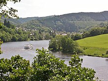
588:
302:
59:
649:
275:
48:
44:
366:
471:
451:
334:
281:
619:
696:
310:
378:
325:. The reservoir, like that of the Rur Dam, belongs to the Eifel-Rur Water Company (
132:
38:
270:
358:
592:
261:
172:
95:
82:
354:
330:
314:
298:
374:
362:
373:
near
Simmerath (borough of Aachen). It is located immediately below the
286:
148:
67:
671:"Zeitreihenauswahl – Rurtalsperre Obersee Beckenpegel (Rurtalsperre)"
627:
289:); right: the overfilled dam foot with spillway of the Urft Reservoir
385:, the large eastern arm of the Obersee in the north lies within the
650:
Topographic
Information Management, Cologne - NRW GEObasis Division
609:(WVER), retrieved 7 May 2016, auf wver.de (PDF; 1,65 MB)
318:
280:
269:
128:
285:
The
Obersee and Urft Dam. Left: the Obersee (pre-dam of the
438:
450:The Obersee. its eastern arm was, like that of the
255:
224:
216:
208:
203:
195:
187:
179:
166:
158:
146:
138:
124:
119:
111:
74:
55:
31:
26:Dam in Borough of Aachen, North Rhine-Westphalia
8:
620:"Stauanlagenverzeichnis Nordrhein-Westfalen"
645:
643:
411:Behind: the pumpwork and broad-crested weir
534:
532:
530:
528:
526:
524:
522:
520:
456:former military training area at Vogelsang
37:
28:
321:mountains of Germany. Its barrier is the
599:siehe S. 2 → Fußzeile in
581:
579:
516:
396:
16:Lake in North-Rhine Westphalia, Germany
7:
718:Reservoirs in North Rhine-Westphalia
569:
567:
345:The dam system, which comprises the
377:, which impounds the waters of the
14:
483:
463:
443:
431:
416:
399:
703:Dams in North Rhine-Westphalia
1:
573:unknown / unresearched source
423:The weir and pumpwork on the
260:279.6 m above
167:Elevation at crest
383:High Fens-Eifel Nature Park
171:283 m above
749:
595:-Höhe + 0,036 m"
18:
585:Hinweis zu Höhenangaben:
36:
492:Naturerlebnisbad Einruhr
139:Height (foundation)
21:Obersee (disambiguation)
708:Reservoirs in the Eifel
679:Wasserverband Eifel-Rur
607:Wasserverband Eifel-Rur
551:Wasserverband Eifel-Rur
506:List of dams in Germany
327:Wasserverband Eifel-Rur
112:Construction began
290:
278:
64:North Rhine-Westphalia
284:
273:
256:Normal elevation
248:head of the reservoir
239:(Obersee and pre-dam)
623:(PDF; 121,1 KB)
217:Active capacity
43:The Obersee between
19:For other uses, see
543:(PDF; 1,65 MB)
490:The swimming area,
387:Eifel National Park
371:Monschau Hedge Land
361:, southwest of the
235:– 5.15 Rur river km
225:Maximum length
209:Total capacity
92: /
728:1950s architecture
629:-LANUV. 2005-10-20
540:"Die Rurtalsperre"
291:
279:
244:
237:
230:
228:– 4.8 Rur river km
180:Width (crest)
713:Aachen (district)
303:borough of Aachen
268:
267:
251:
240:
233:
188:Width (base)
120:Dam and spillways
60:Borough of Aachen
740:
723:Rock-filled dams
689:
687:
686:
657:
647:
638:
637:
635:
634:
624:
616:
610:
602:Die Rurtalsperre
583:
574:
571:
562:
561:
559:
558:
544:
536:
494:, on the Obersee
487:
478:, on the Obersee
467:
447:
435:
420:
403:
369:and east of the
367:Dreiborn Plateau
357:, a part of the
274:The Obersee and
264:
245:
238:
231:
220:17.9 or 20.8 M m
175:
107:
106:
104:
103:
102:
97:
96:50.600°N 6.389°E
93:
90:
89:
88:
85:
41:
29:
748:
747:
743:
742:
741:
739:
738:
737:
693:
692:
684:
682:
669:
665:
660:
648:
641:
632:
630:
622:
618:
617:
613:
598:
584:
577:
572:
565:
556:
554:
542:
538:
537:
518:
514:
502:
495:
488:
479:
468:
459:
448:
439:
436:
427:
421:
412:
410:
404:
395:
365:, north of the
343:
259:
243:
241:
236:
234:
229:
196:Dam volume
170:
100:
98:
94:
91:
86:
83:
81:
79:
78:
51:
27:
24:
17:
12:
11:
5:
746:
744:
736:
735:
730:
725:
720:
715:
710:
705:
695:
694:
691:
690:
664:
663:External links
661:
659:
658:
639:
611:
575:
563:
515:
513:
510:
509:
508:
501:
498:
497:
496:
489:
482:
480:
472:passenger boat
469:
462:
460:
454:, part of the
452:Urft Reservoir
449:
442:
440:
437:
430:
428:
422:
415:
413:
408:Paulushofdamm.
405:
398:
394:
391:
353:, lies in the
342:
339:
335:drinking water
266:
265:
262:sea level (NN)
257:
253:
252:
226:
222:
221:
218:
214:
213:
210:
206:
205:
201:
200:
197:
193:
192:
189:
185:
184:
181:
177:
176:
173:sea level (NN)
168:
164:
163:
160:
156:
155:
152:
144:
143:
140:
136:
135:
126:
122:
121:
117:
116:
113:
109:
108:
76:
72:
71:
57:
53:
52:
42:
34:
33:
25:
15:
13:
10:
9:
6:
4:
3:
2:
745:
734:
731:
729:
726:
724:
721:
719:
716:
714:
711:
709:
706:
704:
701:
700:
698:
680:
676:
672:
667:
666:
662:
655:
651:
646:
644:
640:
628:
621:
615:
612:
608:
604:
603:
596:
594:
591:-Höhe =
590:
582:
580:
576:
570:
568:
564:
552:
548:
541:
535:
533:
531:
529:
527:
525:
523:
521:
517:
511:
507:
504:
503:
499:
493:
486:
481:
477:
473:
466:
461:
457:
453:
446:
441:
434:
429:
426:
425:Paulushofdamm
419:
414:
409:
402:
397:
392:
390:
388:
384:
380:
376:
372:
368:
364:
360:
356:
352:
348:
347:Paulushofdamm
340:
338:
336:
332:
328:
324:
323:Paulushofdamm
320:
316:
312:
311:Rur Reservoir
308:
304:
300:
296:
288:
283:
277:
272:
263:
258:
254:
249:
232:(nur Obersee)
227:
223:
219:
215:
211:
207:
202:
198:
194:
190:
186:
182:
178:
174:
169:
165:
161:
157:
153:
150:
147:Height (
145:
141:
137:
134:
130:
127:
123:
118:
114:
110:
105:
101:50.600; 6.389
77:
73:
69:
65:
61:
58:
54:
50:
46:
40:
35:
30:
22:
683:. Retrieved
674:
668:Pegeldaten:
631:. Retrieved
614:
601:
586:
555:. Retrieved
546:
491:
475:
424:
407:
350:
346:
344:
326:
322:
305:is the main
294:
292:
359:North Eifel
99: /
75:Coordinates
697:Categories
685:2016-05-07
633:2013-09-09
557:2016-05-07
512:References
84:50°36′00″N
733:Rur basin
355:Rur Eifel
333:provides
331:reservoir
315:River Rur
299:Simmerath
242:– 13.4 km
204:Reservoir
199:320,000 m
87:6°23′20″E
500:See also
375:Urft Dam
363:Kermeter
341:Location
246:(to the
125:Impounds
56:Location
675:wver.de
547:wver.de
351:Obersee
329:). The
317:in the
313:on the
309:of the
307:forebay
301:in the
295:Obersee
287:Rur Dam
276:Einruhr
149:thalweg
68:Germany
49:Rurberg
45:Einruhr
32:Obersee
681:(WVER)
553:(WVER)
393:Photos
212:23 M m
183:14.0 m
159:Length
115:?–1959
476:Eifel
319:Eifel
297:near
191:135 m
162:280 m
654:info
470:The
406:The
379:Urft
349:and
293:The
154:27 m
142:33 m
133:Urft
47:and
589:NHN
129:Rur
699::
677:.
673:.
642:^
625:.
605:,
593:NN
578:^
566:^
549:.
545:.
519:^
474:,
389:.
337:.
131:,
62:,
688:.
656:)
652:(
636:.
597:;
587:"
560:.
458:.
250:)
151:)
70:)
66:(
23:.
Text is available under the Creative Commons Attribution-ShareAlike License. Additional terms may apply.