425:
these divergent boundaries, convection currents in the mantle rise up as magma, emerge through the rifts as lava, and crystallise as new rock (basalts and gabbro). These processes continually create new ocean crust. Hydrothermal vents, which typically form along these mid-ocean ridges, are fissures from which geothermally heated water flows. The water flowing out of vents is dominantly seawater drawn into the system through the faults, porous sediments, and volcanic rocks. As the cool seawater moves through the sediment and rock towards the hot magma, the water becomes super heated (300-400 °C) and rich in dissolved mineral elements (such as sulphur, iron, zinc and copper) from the young ocean crust. When the hot effluent is expelled, it encounters the cold, ambient seawater (about 2 °C) minerals precipitate from the element-rich vent water. At the
Endeavour segment, a notably vigorous venting area, black smokers form at the high temperature vents, where the effluent is precipitating iron sulphides. This gives the plumevits dark colour and deposits sulphide-minerals, creating chimneys up to 30 m in height. There are 6 known vent fields with distinct morphologies spaced about 2 km apart along the axial rift valley of the segment.
323:
of the areas within
Barkley Canon are characterised by a soft, finely sedimented seafloor. Video observations suggest that animal densities are higher at the shallower sites compared with the deeper sites, although most species are present at all sites. A number of fish including sablefish, thornyheads, rockfish, flatfish, sharks, skates, hagfish and eelpouts have been observed throughout Barkley Canyon. The area is rich with invertebrates as well including molluscs (bivalves, octopus, snails), echinoderms (sea stars, brittle stars, sea cucumbers, and urchins) as well as arthropods (crabs and shrimp). Cnidarians are seen both on the seafloor (anemones, sea pens, and corals) as well as floating in the water column (jellyfish) along with other organisms such as salps, ctenophores, and tunicates.
260:
442:
336:
207:
220:
413:
433:). These bacteria can be free-living or symbiotic and are the base of the food web of these communities where 90% of the species are endemic to this special environment. The tubeworm Ridgeia piscesae grows in large colonies in diffuse venting areas, supported by the symbiotic chemosynthetic bacteria developing in their cells. These worms have no mouth and rely on their internal symbiotic bacteria to survive. Other species living within hydrothermal communities include limpets, worms (scale worms and sulphide worms), fish, and sea spiders.
469:
variety of rockfish (yellowtail, China, quillback, Puget Sound, black, and blue) in addition to many other fish (kelp greenling, lingcod, flatfish, wolfeels), molluscs (giant
Pacific octopus, mussels, swimming scallops, and snails), and echinoderms (seastars, sea cucumbers, and urchins). An echosounder installed at Folger Deep shows evidence of a dense zooplankton community and schools of fish in the water column, while hydrophones regularly record the songs of whales and dolphins in the area.
355:
there is a fairly diverse community living on the abyssal plain. Installation and maintenance work has enabled a number of these organisms to be observed. The main groups of organisms observed include fish (skates and rattails), echinoderms (sea cucumbers, sea stars, brittle stars, and crinoids), molluscs (octopus and squid), sea pens, crabs, and squat lobsters. A number of pelagic (living in the water column) organisms were observed such as squid, jellyfish, ostracods, ctenophores, and salps.
351:, the original eastern Pacific oceanic plate, which has been almost entirely subducted beneath North America. The flat sediment surface constitutes an abyssal plain, an exceedingly vast environment that covers over 50% of the planet’s surface. Seemingly inhospitable, with temperatures below 2 °C, high-pressures, and a total absence of light, the Cascadia Basin is nevertheless home to an assortment of well-adapted organisms.
461:, British Columbia. The seafloor composition includes cobble, gravel, soft sandy sediment, and carbonate-rich detritus. Two instrument platforms, Folger Deep (100 m) and Folger Pinnacle (23 m), are installed at Folger Passage. Folger Deep is situated on soft sediment at the mouth of an inlet channel while the Folger Pinnacle platform is secured to the top of a rocky reef within a rockfish conservation area.
359:
obviation retrofit kit (CORK) borehole observatories, which are designed to study the hydrology, geochemistry and microbiology of the upper oceanic crust. CORKs are also being used to investigate changes in regional plate strain that are caused by earthquakes on the plate boundaries. The seafloor pressure measurements of the CORK borehole observatories constitute the center of a “
306:, this site supports the study of the accretionary prism, where the sediments pile along the continental slope as they are scraped off the subducting or descending tectonic plate. This is also a location where pressure, temperature, gas saturation, and local biological and chemical conditions are just right for exposed gas hydrates to be stable on the seafloor.
109:, and managed by the not-for profit ONC Society. ONC operates unparalleled observatories in the deep ocean and coastal waters of Canada’s three coasts–the Arctic, the Pacific and the Atlantic–gathering biological, chemical, geological and physical data to drive solutions for science, industry and society. ONC operates the
428:
These tall sulphide chimneys (hydrothermal vents) host some unique ecological communities. While most of the deep sea depends on near-surface productivity with photosynthesis as its fundamental energy source, vent communities are completely independent from the surface and sunlight. Bacteria are able
358:
A few isolated outcropping seamounts that pierce through more than 200 m of impermeable sediments, are conduits that allow hydrologic exchange between the open ocean and the upper oceanic crust—the largest aquifer of the planet. The
Cascadia Basin site is placed in the vicinity of several circulation
322:
Organisms living in the depths of
Barkley Canyon have evolved to be able to persist in areas with high pressure, no light, and low nutrients/food availability. The Barkley Canyon instruments span a diversity of habitats, each of which is associated with its own specialized biological community. Most
318:
system). The direction and strength of the currents regulate the upwelling/downwelling regime along the coast, with a flow towards the equator in summer (California current) and reversal in winter (Alaska current). In addition to these two currents, a large submarine canyon acts as a primary conduit
464:
This coastal zone is ideal for studies of land-ocean interactions and coastal physical oceanography. Estuarine circulation from
Barkley Sound is influenced by the shelf dynamics of an eastern boundary current, creating a complex physical environment. Surface outflow drives a deep water inflow which
424:
which, in turn, is part of the complex, 80,000 km long mid-ocean ridge system spanning the World Ocean. Juan de Fuca Ridge is a medium rate spreading centre (~6 cm/yr) forming the divergent boundary between the
Pacific (to the west) and the Juan de Fuca (to the east) tectonic plates . At
354:
Depending mostly on marine snow—the continuous shower of mostly organic detritus falling from surface waters—little is known about the complicated food web connecting the organisms of the deep. Because of the harsh environment, there is a low density of organisms observed. Despite the low density,
326:
Where gas hydrates are observed on the seafloor, there are mats of chemosynthetic bacteria which derive their energy from hydrogen sulphide produced by the oxidate of methane by a second group of microbes living deep within the sediments. Other chemosynthetic sulphide-oxidizing bacteria live in
468:
Folger
Pinnacle, located atop a shallow reef, has dense mats of sponges, ascidians and encrusting algae. There are numerous types of sessile (bottom attached) organisms including sponges, anemones, bryozoans, tunicates, and barnacles. Since this is a rockfish conservation area, there is a wide
228:
Saanich Inlet, at the southern end of
Vancouver Island, Canada, is a naturally hypoxic basin. A shallow sill (70 m) at the mouth isolates the deep basin (215 m) that experiences seasonal deep-water anoxia as a result of high primary productivity and subsequent degradation of sedimented organic
403:
Clayoquot Slope is home to a variety of deep-sea organisms. Many demersal fish (fish which live very near the bottom) were observed (rockfish, flatfish, thorny heads, and rattails) along with echinoderms (sea cucumbers, brittle stars, sea stars), octopus, crabs, cnidarians (sea pens, corals,
395:
is subducting (descending) beneath the North
American Plate. This is a zone where much of the thick layer of sediments deposited on the eastern flank of the Juan de Fuca Ridge are scraped off and accreted as the tectonic plates converge (move together). As sediments thicken and compact from
233:
and an autonomous mooring at the entrance (sill) to the inlet. Two cabled surface buoys are connected to the Patricia Bay installation, supporting a technology testbed facility (Patricia Bay) and a full water column observation station (Coles Bay). Patricia Bay installations include:
1131:
Riedel, M., and E. C. Willoughby (2010), Gas hydrates - Geophysical exploration techniques and methods, in Geophysical Characterization of Gas Hydrates, edited by M. Riedel, E. C. Willoughby, and S. Chopra, pp. 1–13, Society of Exploration Geophysicists, Tulsa. Available from:
223:
2013 map of Ocean Networks Canada installations in Saanich Inlet between Sidney and Mill Bay, BC, on the east coast of Vancouver Island. This is one of the sites on the VENUS observatory. The University of Victoria's Ocean Technology Test Bed is located here as
930:
Juniper, S. Kim; Matabos, Marjolaine; Mihály, Steven; Ajayamohan, R.S.; Gervais, Françoise; Bui, Alice O.V. (August 2013). "A year in Barkley Canyon: A time-series observatory study of mid-slope benthos and habitat dynamics using the NEPTUNE Canada network".
182:
Altogether, the system includes 3 observatories, 5 shore stations, 850+ km of seafloor backbone cables, 11 instrumented sites, 32 instrument platforms, 6 mobile instrument platforms, 400+ instruments and over 2000 scientific sensors deployed.
310:
have gas molecules, typically methane in marine environments, trapped within “cages” of water molecules. This gives them a crystalline structure that resembles ice and can appear as white to yellow mounds covered by sediment on the seafloor.
922:
Juniper, S. K., S. D. McLean, B. Pirenne, R. M. Flagg, and A. O. Bui (2014), First Results from a Real-Time Cabled Observatory in the Canadian Arctic Ocean, in Ocean Sciences Meeting 2014, Ocean Sciences Meetings, Honolulu. Available from:
465:
is strongly influenced by upwelling and downwelling conditions on the nearby continental shelf. The nutrient-rich, terrestrial freshwater discharge and the nutrient-rich, cool, salty upwelled water support a diverse and abundant ecosystem
133:, MACHO and DONET, scientific instruments connected to Ocean Networks Canada are operated remotely and provide continuous streams of freely available data to researchers and the public. Over 200 gigabytes of data are collected every day.
1039:
Matabos, M., M. Best, J. Blandin, M. Hoeberechts, S. K. Juniper, B. Pirenne, K. Robert, H. Ruhl, and M. Varadaro (2012), Seafloor Observatories, in Biological Sampling in the Deep Sea, edited by M. Consalvey and M. Clark, Wiley-Blackwell
129:., Campbell River, Kitamaat Village and Digby Island. These observatories collect data on physical, chemical, biological, and geological aspects of the ocean over long time periods. As with other ocean observatories such as ESONET,
1177:
Wang, C., and R. Pawlowicz (2014), High Spatial and Temporal Resolution Oxygen Measurements in the Strait of Georgia and Their Relationship to Primary Production, in Ocean Sciences Meeting 2014, Honolulu. Available from:
1173:
Scherwath, M., G. Spence, M. Riedel, and M. Heesemann (2012), Gas Release Near Bullseye Vent - New Observations From NEPTUNE Canada"s Seafloor Cable, in Fall Meeting, AGU, p. OS43A–1794, American Geophysical Union, San
744:
Barnes, Christopher R.; Best, Mairi M. R.; Johnson, Fern R.; Pautet, Lucie; Pirenne, Benoit (2011). "Challenges, benefits and opportunities in operating cabled ocean observatories: Perspectives from NEPTUNE Canada".
893:
Kelley, Deborah S.; Delaney, John R.; Juniper, S. Kim (June 2014). "Establishing a new era of submarine volcanic observatories: Cabling Axial Seamount and the Endeavour Segment of the Juan de Fuca Ridge".
363:-meter”, a network of several high precision, rapid sampling bottom pressure recorders (BPRs), that allows precise determination of deep water tsunami amplitude, direction of propagation, and speed.
445:
2013 map of Ocean Networks Canada installations at Folger Passage in Barkley Sound, on the west coast of Vancouver Island. This site is part of the NEPTUNE observatory in the northeast Pacific.
1218:
404:
anemones), and bacterial mats. In the water column, organisms such as squid, krill, jellyfish, siphonophores, and larvaceans have been observed during installation and maintenance work.
327:
symbiosis with clams who live at these hydrate mounts. Many of the species observed elsewhere in Barkley Canyon are not dependent on this system but are frequently observed in the area.
416:
2013 map of Ocean Networks Canada installations along the Endeavour segment of the Juan de Fuca mid-ocean ridge in the northeast Pacific. This site is part of the NEPTUNE observatory.
347:
that extends from the base the continental margin to the west where the sediments lap on to the Juan de Fuca Ridge flank. The Juan de Fuca Plate is one of the last remnants of the
828:
Fine, Isaac V.; Kulikov, Evgueni A.; Cherniawsky, Josef Y. (June 2013). "Japan's 2011 Tsunami: Characteristics of Wave Propagation from Observations and Numerical Modelling".
1228:
302:
Barkley Canyon extends from the continental shelf edge at 400 m down the continental slope to the canyon axis at 985 m water depth. Located at the leading edge of the
400:
in the upper few hundred metres of the sediment. At this site, a cold vent, known as Bullseye Vent, has formed along with significant concentrations of gas hydrates.
697:
André, M.; Zaugg, S.; Houégnigan, L.; Sánchez, A. M.; Castell, J. V. (2011). "Listening to the Deep: Live monitoring of ocean noise and cetacean acoustic signals".
314:
The region is influenced by a major ocean current system. Off the coast, the west wind drift current splits to create the Alaska and the California currents (the
1097:
Pawlowicz, Rich; McClure, Bob (2010). "Inverted echosounder for continuous high-resolution water column profiling from the NEPTUNE (Canada) ocean observatory".
960:
Katz, Timor; Yahel, Gitai; Reidenbach, Matt; Tunnicliffe, Verena; Herut, Barak; Crusius, John; Whitney, Frank; Snelgrove, Paul V. R.; Lazar, Boaz (July 2012).
186:
Scientific topics of study that are enabled by data from these observatories include Arctic oceanography, deep-sea biodiversity, marine ecosystem function,
387:
for at least the last 2000 years. The Clayoquot Slope site lies about 1250 m below sea level and approximately 20 km landward of the toe of the
1133:
1114:
762:
687:
1213:
865:
Heesemann, Martin; Juniper, Kim; Hoeberechts, Maia; Matabos, Marjolaine; Mihaly, Steven; Scherwath, Martin; Dewey, Richard (1 April 2013).
263:
2013 map of Ocean Networks Canada's installations in the Salish Sea, which comprise the Strait of Georgia portion of the VENUS observatory.
259:
807:
Dewey, R. K.; Hoeberechts, M.; Moran, K.; Pirenne, B.; Owens, D. (1 December 2013). "Ocean Networks Canada's "Big Data" Initiative".
247:
Surface based Buoy Profiling System (BPS) designed and built for water column measurements off Coles Bay in central Saanich Inlet.
441:
335:
206:
396:
accretion, pore waters are expelled from the sediment, and gases — primarily biogenic methane — contribute to the formation of
219:
130:
412:
747:
2011 IEEE Symposium on Underwater Technology and Workshop on Scientific Use of Submarine Cables and Related Technologies
1046:"A Year in Hypoxia: Epibenthic Community Responses to Severe Oxygen Deficit at a Subsea Observatory in a Coastal Inlet"
239:
670:
Anderson, Gail S. (2009). "Decomposition and Invertebrate Colonization of Cadavers in Coastal Marine Environments".
1233:
384:
371:
The name Clayoquot (pronounced “Clah-quot”) is an anglicized version of Tla-o-qui-aht, the largest nation in the
244:
Surface buoy based Ocean Technology Testbed designed and built to support engineering and technology development.
388:
303:
172:
1223:
1134:
http://www.seg.org/c/document_library/get_file?uuid=0e72d3c0-9535-4e8f-bb94-8dd25b5ca36c&groupId=10161
126:
106:
315:
339:
2013 layout of installations at Ocean Networks Canada's Cascadia Basin site on the NEPTUNE observatory.
190:, gas hydrates, hydrothermal vents, marine mammals, sediment and benthic dynamics and tsunami studies.
1152:
1057:
1018:
973:
940:
903:
881:
837:
816:
706:
866:
267:
A network with three sites on seafloor at Central, East and Fraser Delta locations of the southern
125:. Additionally, Ocean Networks Canada operates smaller community-based observatories offshore from
1179:
924:
1120:
853:
768:
421:
392:
344:
176:
1141:"Surface-sediment bioturbation quantified with cameras on the NEPTUNE Canada cabled observatory"
1110:
1085:
758:
732:
683:
268:
149:
1160:
1102:
1075:
1065:
1026:
991:
981:
948:
911:
845:
793:
750:
722:
714:
675:
454:
279:
Seafloor networks linking 3 nodes at 300 m (Central), 175 m (East), and 170 m (Fraser Delta)
187:
164:
376:
198:
Ocean Networks Canada instrumentations are installed in the following seafloor locations:
275:, Iona Causeway, and Coal Port terminal. Installations in the Strait of Georgia include:
1156:
1061:
1022:
977:
962:"Resuspension by fish facilitates the transport and redistribution of coastal sediments"
944:
907:
885:
841:
820:
710:
1080:
1045:
430:
372:
348:
1207:
857:
450:
168:
145:
118:
1124:
772:
718:
458:
397:
307:
230:
153:
62:
1070:
915:
679:
105:
is a world-leading research and ocean observing facility hosted and owned by the
1106:
952:
986:
961:
849:
272:
229:
matter. The Saanich Inlet network consists of cabled arrays of instruments in
141:
122:
43:
798:
781:
754:
175:, on the Cascadia Basin abyssal plain, and on the Endeavour segment of the
1089:
736:
1031:
1006:
319:
for the transfer of sediment from the continental slope to the deep-sea.
360:
210:
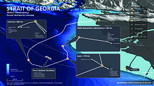
Ocean Networks Canada installations and data sources in the Salish Sea.
160:
110:
1165:
1140:
727:
996:
429:
to use reduced compounds from the vent effluent as an energy source (
380:
68:
238:
Seafloor network at 100 m depth connected to a shore station at the
782:"Diffuse Flow On and Around Hydrothermal Vents at Mid-Ocean Ridges"
440:
411:
334:
258:
218:
205:
137:
114:
1180:
http://www.sgmeet.com/osm2014/viewabstract.asp?AbstractID=14626
925:
http://www.sgmeet.com/osm2014/viewabstract.asp?AbstractID=17329
867:"Ocean Networks Canada: Live Sensing of a Dynamic Ocean System"
80:
780:
Bemis, Karen; Lowell, Robert; Farough, Aida (1 March 2012).
420:
Endeavour (depth 2200–2400 m) is a northern segment of the
1193:
933:
Deep Sea Research Part II: Topical Studies in Oceanography
1044:
Matabos, M; Tunnicliffe, V; Juniper, SK; Dean, C (2012).
375:(Nootka) First Nations, whose people have resided in the
391:. The Cascadia subduction zone is the area at which the
282:
Shore-based High Frequency radar (CODAR with 2 antennas)
16:
University research facility in British Columbia, Canada
1005:
Lintern, D. Gwyn; Hill, Philip R. (21 September 2010).
343:
The Cascadia Basin is the heavily sediment part of the
89:
1007:"An Underwater Laboratory at the Fraser River Delta"
285:
Instrumentation on BC Ferries vessels ("Seekeeper")
140:Observatory is situated at three main sites in the
75:
57:
49:
39:
24:
1219:Organizations based in Victoria, British Columbia
163:observatory is situated off the west coast of
8:
1011:Eos, Transactions American Geophysical Union
117:cabled ocean observatories in the northeast
19:
449:Folger Passage is located at the mouth of
18:
1164:
1079:
1069:
1030:
995:
985:
797:
726:
250:Autonomous Underwater Vehicle ("Bluefin")
1229:Research institutes established in 2007
672:Current Concepts in Forensic Entomology
478:
148:(depth 100 m), the eastern and central
1139:Robert, K; Juniper, SK (7 May 2012).
7:
14:
611:Matabos, Tunnicliffe et al, 2012
719:10.1016/j.marpolbul.2011.04.038
271:, and surface-based systems on
1145:Marine Ecology Progress Series
874:Geophysical Research Abstracts
131:Ocean Observatories Initiative
1:
1099:Oceans 2010 MTS/IEEE Seattle
1071:10.1371/journal.pone.0045626
916:10.1016/j.margeo.2014.03.010
680:10.1007/978-1-4020-9684-6_12
288:Ocean glider (Webb "Slocum")
152:(depths 170–300 m), and the
1214:Oceanographic organizations
1107:10.1109/OCEANS.2010.5664112
830:Pure and Applied Geophysics
656:Pawlowicz and McClure, 2010
557:Riedel and Willoughby, 2010
240:Institute of Ocean Sciences
1250:
966:Limnology and Oceanography
953:10.1016/j.dsr2.2013.03.038
809:AGU Fall Meeting Abstracts
987:10.4319/lo.2012.57.4.0945
850:10.1007/s00024-012-0555-8
539:Wang and Pawlowicz, 22014
521:Juniper and McLean, 2014
485:Juniper and McLean, 2014
389:Cascadia subduction zone
304:Cascadia subduction zone
173:Cascadia subduction zone
799:10.5670/oceanog.2012.16
755:10.1109/UT.2011.5774134
620:Lintern and Hill, 2011
446:
417:
340:
264:
225:
211:
127:Cambridge Bay, Nunavut
107:University of Victoria
638:Scherwath et al, 2012
512:Heesemann et al, 2013
444:
415:
338:
262:
222:
209:
103:Ocean Networks Canada
20:Ocean Networks Canada
1032:10.1029/2010EO380001
674:. pp. 223–272.
1157:2012MEPS..453..137R
1062:2012PLoSO...745626M
1023:2010EOSTr..91..333L
978:2012LimOc..57..945K
945:2013DSRII..92..114J
908:2014MGeol.352..426K
886:2013EGUGA..15.6625H
842:2013PApGe.170.1295F
821:2013AGUFM.U41A..02D
711:2011MarPB..63...18A
629:Juniper et al, 2013
530:Matabos et al, 2013
21:
836:(6–8): 1295–1307.
647:Kelley et al, 2014
593:Robert et al, 2012
503:Barnes et al, 2011
447:
422:Juan de Fuca Ridge
418:
393:Juan de Fuca Plate
345:Juan de Fuca Plate
341:
316:California current
265:
226:
212:
177:Juan de Fuca Ridge
1234:Research projects
1166:10.3354/meps09623
1116:978-1-4244-4332-1
764:978-1-4577-0165-8
699:Mar. Pollut. Bull
689:978-1-4020-9683-9
575:André et al, 2011
566:Bemis et al, 2012
494:Dewey et al, 2013
293:Northeast Pacific
269:Strait of Georgia
255:Strait of Georgia
150:Strait of Georgia
100:
99:
1241:
1197:
1196:
1194:Official website
1170:
1168:
1128:
1101:. pp. 1–8.
1093:
1083:
1073:
1036:
1034:
1001:
999:
989:
956:
919:
889:
880:: EGU2013–6625.
871:
861:
824:
803:
801:
776:
749:. pp. 1–7.
740:
730:
693:
657:
654:
648:
645:
639:
636:
630:
627:
621:
618:
612:
609:
603:
602:Fine et al, 2013
600:
594:
591:
585:
584:Katz et al, 2012
582:
576:
573:
567:
564:
558:
555:
549:
546:
540:
537:
531:
528:
522:
519:
513:
510:
504:
501:
495:
492:
486:
483:
455:Vancouver Island
188:marine forensics
165:Vancouver Island
96:
93:
91:
87:
84:
82:
35:
33:
22:
1249:
1248:
1244:
1243:
1242:
1240:
1239:
1238:
1204:
1203:
1201:
1192:
1191:
1188:
1138:
1117:
1096:
1043:
1017:(38): 333–334.
1004:
959:
929:
892:
869:
864:
827:
806:
779:
765:
743:
696:
690:
669:
666:
661:
660:
655:
651:
646:
642:
637:
633:
628:
624:
619:
615:
610:
606:
601:
597:
592:
588:
583:
579:
574:
570:
565:
561:
556:
552:
547:
543:
538:
534:
529:
525:
520:
516:
511:
507:
502:
498:
493:
489:
484:
480:
475:
439:
410:
377:Clayoquot Sound
369:
367:Clayoquot Slope
333:
300:
295:
257:
217:
204:
196:
88:
79:
71:
65:
31:
29:
17:
12:
11:
5:
1247:
1245:
1237:
1236:
1231:
1226:
1221:
1216:
1206:
1205:
1199:
1198:
1187:
1186:External links
1184:
1183:
1182:
1175:
1171:
1136:
1129:
1115:
1094:
1041:
1037:
1002:
972:(4): 945–958.
957:
927:
920:
896:Marine Geology
890:
862:
825:
804:
792:(1): 182–191.
777:
763:
741:
705:(1–4): 18–26.
694:
688:
665:
662:
659:
658:
649:
640:
631:
622:
613:
604:
595:
586:
577:
568:
559:
550:
541:
532:
523:
514:
505:
496:
487:
477:
476:
474:
471:
438:
437:Folger Passage
435:
431:chemosynthesis
409:
406:
373:Nuu-chah-nulth
368:
365:
349:Farallon Plate
332:
331:Cascadia Basin
329:
299:
298:Barkley Canyon
296:
294:
291:
290:
289:
286:
283:
280:
256:
253:
252:
251:
248:
245:
242:
216:
213:
203:
200:
195:
192:
98:
97:
83:.oceannetworks
77:
73:
72:
67:
61:
59:
55:
54:
51:
47:
46:
41:
37:
36:
26:
15:
13:
10:
9:
6:
4:
3:
2:
1246:
1235:
1232:
1230:
1227:
1225:
1224:Pacific Ocean
1222:
1220:
1217:
1215:
1212:
1211:
1209:
1202:
1195:
1190:
1189:
1185:
1181:
1176:
1172:
1167:
1162:
1158:
1154:
1150:
1146:
1142:
1137:
1135:
1130:
1126:
1122:
1118:
1112:
1108:
1104:
1100:
1095:
1091:
1087:
1082:
1077:
1072:
1067:
1063:
1059:
1056:(9): e45626.
1055:
1051:
1047:
1042:
1038:
1033:
1028:
1024:
1020:
1016:
1012:
1008:
1003:
998:
993:
988:
983:
979:
975:
971:
967:
963:
958:
954:
950:
946:
942:
938:
934:
928:
926:
921:
917:
913:
909:
905:
901:
897:
891:
887:
883:
879:
875:
868:
863:
859:
855:
851:
847:
843:
839:
835:
831:
826:
822:
818:
814:
810:
805:
800:
795:
791:
787:
783:
778:
774:
770:
766:
760:
756:
752:
748:
742:
738:
734:
729:
724:
720:
716:
712:
708:
704:
700:
695:
691:
685:
681:
677:
673:
668:
667:
663:
653:
650:
644:
641:
635:
632:
626:
623:
617:
614:
608:
605:
599:
596:
590:
587:
581:
578:
572:
569:
563:
560:
554:
551:
548:Anderson 2010
545:
542:
536:
533:
527:
524:
518:
515:
509:
506:
500:
497:
491:
488:
482:
479:
472:
470:
466:
462:
460:
456:
452:
451:Barkley Sound
443:
436:
434:
432:
426:
423:
414:
407:
405:
401:
399:
394:
390:
386:
382:
378:
374:
366:
364:
362:
356:
352:
350:
346:
337:
330:
328:
324:
320:
317:
312:
309:
305:
297:
292:
287:
284:
281:
278:
277:
276:
274:
270:
261:
254:
249:
246:
243:
241:
237:
236:
235:
232:
221:
215:Saanich Inlet
214:
208:
201:
199:
193:
191:
189:
184:
180:
178:
174:
170:
169:Barkley Sound
166:
162:
157:
155:
151:
147:
146:Saanich Inlet
143:
139:
134:
132:
128:
124:
120:
119:Pacific Ocean
116:
112:
108:
104:
95:
86:
78:
74:
70:
64:
60:
56:
52:
48:
45:
42:
38:
27:
23:
1200:
1148:
1144:
1098:
1053:
1049:
1014:
1010:
969:
965:
936:
932:
899:
895:
877:
873:
833:
829:
812:
808:
789:
786:Oceanography
785:
746:
702:
698:
671:
652:
643:
634:
625:
616:
607:
598:
589:
580:
571:
562:
553:
544:
535:
526:
517:
508:
499:
490:
481:
467:
463:
448:
427:
419:
402:
398:gas hydrates
379:region near
370:
357:
353:
342:
325:
321:
313:
308:Gas hydrates
301:
266:
231:Patricia Bay
227:
197:
185:
181:
171:, along the
158:
154:Fraser River
144:, including
135:
102:
101:
63:Victoria, BC
1151:: 137–149.
1040:publishing.
939:: 114–123.
902:: 426–450.
815:: U41A–02.
453:, offshore
194:Study sites
53:150 Approx.
25:Established
1208:Categories
1174:Francisco.
728:2117/12808
664:References
273:BC Ferries
202:Salish Sea
142:Salish Sea
123:Salish Sea
44:Kate Moran
997:1912/6564
858:140721563
408:Endeavour
40:President
1125:30021062
1090:23029145
1050:PLOS ONE
773:11387293
737:21665016
459:Bamfield
385:Ucluelet
121:and the
58:Location
1153:Bibcode
1081:3446942
1058:Bibcode
1019:Bibcode
974:Bibcode
941:Bibcode
904:Bibcode
882:Bibcode
838:Bibcode
817:Bibcode
707:Bibcode
361:tsunami
161:NEPTUNE
156:delta.
111:NEPTUNE
76:Website
30: (
1123:
1113:
1088:
1078:
856:
771:
761:
735:
686:
381:Tofino
69:Canada
1121:S2CID
870:(PDF)
854:S2CID
769:S2CID
473:Notes
457:near
224:well.
138:VENUS
115:VENUS
92:.uvic
50:Staff
1111:ISBN
1086:PMID
759:ISBN
733:PMID
684:ISBN
383:and
159:The
136:The
113:and
32:2007
28:2007
1161:doi
1149:453
1103:doi
1076:PMC
1066:doi
1027:doi
992:hdl
982:doi
949:doi
912:doi
900:352
846:doi
834:170
794:doi
751:doi
723:hdl
715:doi
676:doi
167:in
94:.ca
90:www
85:.ca
81:www
1210::
1159:.
1147:.
1143:.
1119:.
1109:.
1084:.
1074:.
1064:.
1052:.
1048:.
1025:.
1015:91
1013:.
1009:.
990:.
980:.
970:57
968:.
964:.
947:.
937:92
935:.
910:.
898:.
878:15
876:.
872:.
852:.
844:.
832:.
813:41
811:.
790:25
788:.
784:.
767:.
757:.
731:.
721:.
713:.
703:63
701:.
682:.
179:.
66:,
1169:.
1163::
1155::
1127:.
1105::
1092:.
1068::
1060::
1054:7
1035:.
1029::
1021::
1000:.
994::
984::
976::
955:.
951::
943::
918:.
914::
906::
888:.
884::
860:.
848::
840::
823:.
819::
802:.
796::
775:.
753::
739:.
725::
717::
709::
692:.
678::
34:)
Text is available under the Creative Commons Attribution-ShareAlike License. Additional terms may apply.