334:) in downtown Napoleon. SR 110 heads southeast from here concurrent with SR 108. The road passes through commercial properties as a four-lane undivided highway. The highway crosses over the Maumee River and has an intersection with the southern end of the SR 108 concurrency. SR 110 turns northeast, passing commercial properties as a four-lane undivided highway. At a traffic signal with Appian Avenue the route narrows to a two-lane highway and parallels the Maumee River, passes through residential properties. The residential properties end and the highway passes through industrial type properties. The road curves towards the east, still parallel to the river, and passes through farmland, with some woodland. The highway has an interchange with
315:
572:
539:
476:
446:
40:
26:
578:
545:
482:
452:
244:
229:
86:
606:
126:
510:
107:
350:. After the tracks the road curve southeast and SR 109 leaves SR 110 heading north over the Maumee River. The highway continues southeast, before curving northeast passing through a wooded area. The route turns due east and passes through farmland, before its eastern terminus at an intersection with
369:(AADT) calculations showed that the lowest traffic levels were present on the section that is between SR 109 and SR 65, where only 1,500 vehicles used the highway daily; the peak traffic volume was 6,960 vehicles AADT along a section that is concurrent with SR 108.
747:
393:. Also in that year the route was flipped US 24, once again putting SR 110 on the south banks of the Maumee. In 1958, SR 110 was truncated to its current terminus, leaving the road between SR 65 and
889:
283:. Most of the route is a rural two-lane highway and passes through both farmland and commercial properties. For much of its path, SR 110 runs generally parallel to the south of the
377:
SR 110 was originally signed in 1923. At that time SR 110 ran along its current route from
Napoleon to Grand Rapids and along current SR 65 from Grand Rapids to
381:. The current route of SR 110 was paved by 1926. In 1927, SR 110 was moved to run along the north bank of the Maumee River from Napoleon to Grand Rapids, with
1197:
1168:
358:
898:
593:
497:
114:
385:
taking the south bank of the river. In 1931, its eastern terminus was moved to Grand Rapids. In 1942, the eastern terminus was extended to
346:, this interchange is the western end of a concurrency with SR 109. The concurrency heads east passing under railroad tracks owned by
774:
197:
669:
665:
362:
53:
1121:
1094:
1070:
1046:
1022:
998:
974:
950:
923:
723:
696:
1192:
294:. SR 110 was moved to the north side of the Maumee River in 1927. In 1931, the eastern terminus of the route was moved to
840:
319:
366:
207:
831:
202:
1177:
361:, a system of routes important to the nation's economy, mobility and defense. The highway is maintained by the
347:
382:
314:
290:
The highway was first signed in 1923 on much the same alignment as today, bur got as far northeast as
582:
549:
513:
486:
456:
390:
343:
335:
331:
327:
247:
232:
110:
89:
609:
521:
394:
386:
351:
303:
299:
129:
636:
613:
406:
339:
295:
172:
1159:
804:
212:
863:
378:
291:
298:. The route was moved back to the south side of the river and the route was extended to
432:
272:
93:
1186:
617:
553:
276:
268:
152:
133:
397:
unnumbered. No significant changes have taken place to this state route since 1958.
284:
979:(Map). Cartography by ODOHPW. Ohio Department of Highways and Public Works. 1927
955:(Map). Cartography by ODOHPW. Ohio Department of Highways and Public Works. 1926
928:(Map). Cartography by ODOHPW. Ohio Department of Highways and Public Works. 1925
752:
728:(Map). Cartography by ODOHPW. Ohio Department of Highways and Public Works. 1923
701:(Map). Cartography by ODOHPW. Ohio Department of Highways and Public Works. 1922
517:
302:
in 1942. The eastern terminus of SR 110 was moved to the intersection with
782:(Map). Cartography by ODOT. Ohio Department of Transportation. December 2008
39:
862:
Natzke, Stefan; Neathery, Mike; Adderly, Kevin (September 26, 2012).
322:
in
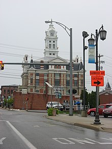
Napoleon. The 2009 photo also shows signage for the former SR 424.
812:(Map). Cartography by ODOT. Ohio Department of Transportation. 2011
326:
SR 110 begins at the intersection of
Riverview Avenue (former
568:
535:
472:
442:
313:
25:
1167:
1126:(Map). Cartography by ODOH. Ohio Department of Highways and. 1958
280:
162:
897:(Map). Ohio Department of Transportation. 2011. Archived from
1099:(Map). Cartography by ODOH. Ohio Department of Highways. 1957
1075:(Map). Cartography by ODOH. Ohio Department of Highways. 1942
1051:(Map). Cartography by ODOH. Ohio Department of Highways. 1941
1027:(Map). Cartography by ODOH. Ohio Department of Highways. 1931
1003:(Map). Cartography by ODOH. Ohio Department of Highways. 1930
626:
1.000 mi = 1.609 km; 1.000 km = 0.621 mi
1155:
1150:
587:
557:
491:
461:
489:
south (South Perry Street) / West Maumee Avenue
182:
168:
158:
148:
143:
120:
99:
80:
75:
67:
59:
46:
21:
342:. East of the interchange is an intersection with
318:The western terminus of SR 110 is in front of the
1116:
1114:
945:
943:
718:
716:
691:
689:
8:
459:north (Perry Street) / Riverview Avenue
799:
797:
670:"Technical Services Straight Line Diagrams"
1169:Template:Attached KML/Ohio State Route 110
411:
221:
1172:
654:
492:Southern end of SR 108 concurrency
462:Northern end of SR 108 concurrency
16:State highway in Henry County, Ohio, US
864:"What is the National Highway System?"
588:Eastern end of SR 109 concurrency
558:Western end of SR 109 concurrency
18:
660:
658:
603:
597:
562:
529:
507:
501:
466:
436:
7:
1198:Transportation in Henry County, Ohio
891:Traffic Survey Report - Henry County
748:"Overview of Ohio State Route 110"
267:) is a 10.73-mile (17.27 km)
63:10.73 mi (17.27 km)
14:
666:Ohio Department of Transportation
363:Ohio Department of Transportation
870:. Federal Highway Administration
604:
576:
570:
543:
537:
508:
480:
474:
450:
444:
242:
227:
124:
105:
84:
38:
24:
1178:State Route 110 Endpoint Photos
357:SR 110 is not part of the
841:Federal Highway Administration
1:
833:National Highway System: Ohio
367:annual average daily traffic
1214:
1123:Official Ohio Highway Map
1096:Official Ohio Highway Map
1072:Official Ohio Highway Map
1048:Official Ohio Highway Map
1024:Official Ohio Highway Map
1000:Official Ohio Highway Map
976:Official Ohio Highway Map
952:Official Ohio Highway Map
925:Official Ohio Highway Map
776:Map of Henry County, Ohio
725:Official Ohio Highway Map
698:Official Ohio Highway Map
625:
621:
600:
592:
565:
532:
525:
504:
496:
469:
439:
431:
426:
423:
420:
417:
414:
220:
191:Ohio State Highway System
187:
178:
139:
51:
37:
632:
348:Indiana and Ohio Railway
868:National Highway System
405:The entire route is in
359:National Highway System
320:Henry County Courthouse
1193:State highways in Ohio
323:
338:(US 6) in rural
317:
1173:KML is from Wikidata
365:(ODOT). ODOT's 2011
330:) and Perry Street (
401:Major intersections
279:in the US state of
101:Major intersections
324:
271:that runs between
647:
646:
594:Damascus Township
498:Harrison Township
310:Route description
258:
257:
254:
253:
115:Harrison Township
47:Route information
1205:
1163:
1136:
1135:
1133:
1131:
1118:
1109:
1108:
1106:
1104:
1091:
1085:
1084:
1082:
1080:
1067:
1061:
1060:
1058:
1056:
1043:
1037:
1036:
1034:
1032:
1019:
1013:
1012:
1010:
1008:
995:
989:
988:
986:
984:
971:
965:
964:
962:
960:
947:
938:
937:
935:
933:
920:
914:
913:
911:
909:
904:on March 5, 2016
903:
896:
886:
880:
879:
877:
875:
859:
853:
852:
850:
848:
838:
828:
822:
821:
819:
817:
811:
806:Ohio Highway Map
801:
792:
791:
789:
787:
781:
771:
765:
764:
762:
760:
744:
738:
737:
735:
733:
720:
711:
710:
708:
706:
693:
684:
683:
681:
679:
674:
662:
640:
633:
608:
607:
581:
580:
579:
574:
573:
548:
547:
546:
541:
540:
512:
511:
485:
484:
483:
478:
477:
455:
454:
453:
448:
447:
412:
250:
246:
245:
235:
231:
230:
222:
128:
127:
109:
108:
102:
88:
87:
42:
28:
19:
1213:
1212:
1208:
1207:
1206:
1204:
1203:
1202:
1183:
1182:
1174:
1171:
1166:
1165:
1164:
1148:
1144:
1139:
1129:
1127:
1120:
1119:
1112:
1102:
1100:
1093:
1092:
1088:
1078:
1076:
1069:
1068:
1064:
1054:
1052:
1045:
1044:
1040:
1030:
1028:
1021:
1020:
1016:
1006:
1004:
997:
996:
992:
982:
980:
973:
972:
968:
958:
956:
949:
948:
941:
931:
929:
922:
921:
917:
907:
905:
901:
894:
888:
887:
883:
873:
871:
861:
860:
856:
846:
844:
843:. December 2003
836:
830:
829:
825:
815:
813:
809:
803:
802:
795:
785:
783:
779:
773:
772:
768:
758:
756:
746:
745:
741:
731:
729:
722:
721:
714:
704:
702:
695:
694:
687:
677:
675:
672:
664:
663:
656:
652:
643:
635:
631:
627:
605:
577:
575:
571:
569:
544:
542:
538:
536:
509:
481:
479:
475:
473:
451:
449:
445:
443:
403:
375:
312:
261:State Route 110
243:
241:
228:
226:
125:
106:
100:
85:
76:Major junctions
33:
32:
31:State Route 110
29:
17:
12:
11:
5:
1211:
1209:
1201:
1200:
1195:
1185:
1184:
1181:
1180:
1147:
1146:
1145:
1143:
1142:External links
1140:
1138:
1137:
1110:
1086:
1062:
1038:
1014:
990:
966:
939:
915:
881:
854:
823:
793:
766:
739:
712:
685:
653:
651:
648:
645:
644:
642:
641:
628:
623:
622:
620:
602:
599:
596:
590:
589:
586:
567:
564:
560:
559:
556:
534:
531:
527:
526:
524:
506:
503:
500:
494:
493:
490:
471:
468:
464:
463:
460:
441:
438:
435:
429:
428:
425:
422:
419:
416:
402:
399:
374:
371:
311:
308:
256:
255:
252:
251:
238:
236:
218:
217:
216:
215:
210:
205:
200:
194:
193:
185:
184:
183:Highway system
180:
179:
176:
175:
170:
166:
165:
160:
156:
155:
150:
146:
145:
141:
140:
137:
136:
122:
118:
117:
103:
97:
96:
82:
78:
77:
73:
72:
69:
65:
64:
61:
57:
56:
52:Maintained by
49:
48:
44:
43:
35:
34:
30:
23:
22:
15:
13:
10:
9:
6:
4:
3:
2:
1210:
1199:
1196:
1194:
1191:
1190:
1188:
1179:
1176:
1175:
1170:
1161:
1157:
1153:
1152:
1141:
1125:
1124:
1117:
1115:
1111:
1098:
1097:
1090:
1087:
1074:
1073:
1066:
1063:
1050:
1049:
1042:
1039:
1026:
1025:
1018:
1015:
1002:
1001:
994:
991:
978:
977:
970:
967:
954:
953:
946:
944:
940:
927:
926:
919:
916:
900:
893:
892:
885:
882:
869:
865:
858:
855:
842:
835:
834:
827:
824:
808:
807:
800:
798:
794:
778:
777:
770:
767:
755:
754:
749:
743:
740:
727:
726:
719:
717:
713:
700:
699:
692:
690:
686:
671:
667:
661:
659:
655:
649:
638:
630:
629:
624:
619:
615:
611:
595:
591:
584:
561:
555:
552:south –
551:
528:
523:
522:Bowling Green
519:
515:
499:
495:
488:
465:
458:
434:
430:
413:
410:
408:
400:
398:
396:
392:
388:
387:Bowling Green
384:
380:
372:
370:
368:
364:
360:
355:
353:
349:
345:
341:
337:
333:
329:
321:
316:
309:
307:
305:
301:
300:Bowling Green
297:
293:
288:
286:
282:
278:
275:and north of
274:
270:
266:
262:
249:
239:
237:
234:
224:
223:
219:
214:
211:
209:
206:
204:
201:
199:
196:
195:
192:
189:
188:
186:
181:
177:
174:
171:
167:
164:
161:
157:
154:
153:United States
151:
147:
142:
138:
135:
131:
123:
121:East end
119:
116:
112:
104:
98:
95:
91:
83:
81:West end
79:
74:
70:
66:
62:
58:
55:
50:
45:
41:
36:
27:
20:
1149:
1128:. Retrieved
1122:
1101:. Retrieved
1095:
1089:
1077:. Retrieved
1071:
1065:
1053:. Retrieved
1047:
1041:
1029:. Retrieved
1023:
1017:
1005:. Retrieved
999:
993:
981:. Retrieved
975:
969:
957:. Retrieved
951:
930:. Retrieved
924:
918:
906:. Retrieved
899:the original
890:
884:
872:. Retrieved
867:
857:
845:. Retrieved
832:
826:
814:. Retrieved
805:
784:. Retrieved
775:
769:
757:. Retrieved
751:
742:
730:. Retrieved
724:
703:. Retrieved
697:
678:November 15,
676:. Retrieved
634:
614:Grand Rapids
424:Destinations
407:Henry County
404:
389:, replacing
376:
356:
340:Henry County
336:U.S. Route 6
325:
296:Grand Rapids
289:
285:Maumee River
264:
260:
259:
190:
71:1923–present
1130:January 29,
1103:January 29,
1079:January 29,
1055:January 29,
1031:January 29,
1007:January 29,
983:January 29,
959:January 29,
932:January 29,
908:January 28,
874:January 29,
847:January 29,
816:January 29,
786:January 29,
759:January 29,
753:Google Maps
732:January 29,
705:January 26,
637:Concurrency
583:SR 109
550:SR 109
487:SR 108
457:SR 108
391:SR 184
344:SR 109
269:state route
265:SR 110
248:SR 111
233:SR 109
90:SR 108
1187:Categories
650:References
610:SR 65
395:SR 64
383:US 24
379:Perrysburg
352:SR 65
304:SR 65
292:Perrysburg
198:Interstate
130:SR 65
514:US 6
306:in 1958.
111:US 6
1151:KML file
639:terminus
612: –
516: –
433:Napoleon
415:Location
273:Napoleon
169:Counties
144:Location
94:Napoleon
839:(Map).
750:(Map).
618:McClure
554:Malinta
373:History
277:McClure
149:Country
134:McClure
68:Existed
332:SR 108
328:SR 424
213:Scenic
60:Length
902:(PDF)
895:(PDF)
837:(PDF)
810:(PDF)
780:(PDF)
673:(PDF)
601:17.27
598:10.73
585:north
566:10.83
518:Bryan
427:Notes
208:State
173:Henry
159:State
132:near
1160:help
1156:edit
1132:2013
1105:2013
1081:2013
1057:2013
1033:2013
1009:2013
985:2013
961:2013
934:2013
910:2012
876:2012
849:2012
818:2013
788:2013
761:2013
734:2013
707:2013
680:2013
563:6.73
533:8.38
530:5.21
505:6.74
502:4.19
470:0.47
467:0.29
440:0.00
437:0.00
281:Ohio
163:Ohio
54:ODOT
113:in
92:in
1189::
1158:•
1113:^
942:^
866:.
796:^
715:^
688:^
668:.
657:^
616:,
520:,
421:km
418:mi
409:.
354:.
287:.
240:→
225:←
203:US
1162:)
1154:(
1134:.
1107:.
1083:.
1059:.
1035:.
1011:.
987:.
963:.
936:.
912:.
878:.
851:.
820:.
790:.
763:.
736:.
709:.
682:.
263:(
Text is available under the Creative Commons Attribution-ShareAlike License. Additional terms may apply.