300:
392:
383:, exit 22 off of the US 24 freeway. SR 424-C has reverted to a township road (Township Road 10) and instead of an at-grade intersection with US 24, an overpass over the new freeway was built. The dead end before the connector between the original US 24 freeway and the two-lane section east of Napoleon has been removed and is now a continuous route. All the roads on the former SR 424 outside of city and village limits are now known as County Road 424.
336:, and 66. SR 111 ends while SR 424 continued with the three state routes north on Clinton Avenue and over the Maumee River on a bridge. Immediately after the bridge, SR 424 turned right onto River Drive while the three other routes continue on Clinton Avenue. From this point to the eastern terminus, SR 424 closely followed the northern bank of the Maumee River. In the eastern neighborhoods of Defiance, SR 424 passed under the bridge that carries
1118:
624:
598:
543:
517:
40:
783:
744:
611:
530:
26:
556:
829:
816:
662:
750:
738:
668:
562:
494:
224:
209:
835:
630:
617:
604:
549:
536:
523:
465:
95:
822:
789:
376:, a 0.17-mile-long (0.27 km) connector route between SR 424 and US 24 provided the access to westbound US 6 and US 24 which was not possible at the previous interchange. The mainline SR 424 continued east along the river past a few houses before coming to a dead end just short of the mainline, two-lane segment of US 24.
415:
progressed, the SR 424 designation was removed and the road transferred to county engineer departments and cities. The westernmost portion of the route in
Defiance County was turned over in November 2008. For about four years, the western terminus of SR 424 was at the Defiance/Henry County line. The
399:
SR 424 was designated in 1964 on the old section of US 24 through
Defiance. At that time, US 24 was routed on a bypass north of the city, but returned to the Maumee River alignment via SR 281. By 1969, when more of the bypass of Defiance and Napoleon opened, SR 424 was extended along the river
311:
SR 424 began at an intersection with US 24 inside the city limits of
Defiance, though 3 miles (4.8 km) west of the center of the city. At this point, the route was also called Baltimore Street. At the intersection with Deatrick Street, the name of the street that carried SR 424 changed to
359:
where the route was also known as High Street. After briefly traveling east to follow the river bank, the route turned north and entered the city limits of
Napoleon. Throughout the city, the route name was Riverview Avenue. In the center of Napoleon, SR 424 intersected
279:. First designated in 1964, the western terminus of the route for most of its history was at an intersection with US 24 west of Defiance, though between 2008 and when the route was fully removed from the state highway system in 2012, it was at the
320:
were designated along this section of SR 424 as well. Continuing northeast, the route made a sharp curve to the southeast and changed its name to West Third Avenue. Shortly after passing under an
989:
1399:
1394:
1371:
964:
695:
341:
1389:
1228:"Ohio Department of Transportation - Office of Technical Services - Road Inventory System RI-134A - Listing of Local Roads Inventory Sections"
1084:
1307:
1280:
1052:
699:
352:
769:
369:
1200:
1148:
328:
in downtown
Defiance. SR 424 turned left onto South Clinton Avenue with the last block of SR 111 before coming to the intersection with
177:
1176:
1025:
985:
62:
1338:
996:
304:
1227:
321:
187:
416:
eastern portion of the route in Henry County was turned over to county and municipal jurisdiction on
December 1, 2012.
345:
182:
380:
379:
Since the decommissioning of the route, the intersection at the original western terminus in
Defiance has become a
1404:
1255:
847:
839:
684:
468:
447:
280:
260:
98:
299:
843:
793:
758:
754:
673:
578:
497:
400:
alignment when US 24 was routed onto the new bypass. SR 424 would remain at this routing until 2008.
365:
361:
337:
325:
317:
288:
268:
227:
212:
1343:
797:
642:
638:
634:
574:
570:
566:
472:
408:
333:
329:
313:
896:
884:
720:
688:
324:
bridge, the route came to a signalized intersection with South
Clinton Avenue which also carries
284:
152:
391:
955:
192:
372:
and had a partial interchange with US 6. 0.2 miles (0.32 km) past the interchange,
348:. Just after the park, the route curved to the northeast and crossed into Henry County.
725:
476:
452:
276:
272:
113:
102:
1383:
404:
356:
248:
132:
1349:
851:
584:
Eastern end of SR 111 concurrency; western end of SR 15 / SR 18 / SR 66 concurrency
412:
264:
1123:
1060:(Map). Cartography by P.E. Masheter, Director. Ohio Department of Highways. 1962
252:
307:
in
Napoleon showing the intersection of SR 424, SR 108, and SR 110 in 2009.
39:
1372:
News
Release, Defiance County Commissioners, Monday, November 10, 2008
340:
over the river; a short connector road provided access to SR 281. In
990:"Technical Services Straight Line Diagrams - SR 424 Defiance County"
1177:"Technical Services Straight Line Diagrams - SR 424-C Henry County"
364:
at Perry Street. This intersection is also the western terminus of
594:
513:
491:
390:
298:
25:
1026:"Technical Services Straight Line Diagrams - SR 424 Henry County"
963:
921:
This length reflects the maximum length the route was designated
256:
142:
779:
874:
1.000 mi = 1.609 km; 1.000 km = 0.621 mi
1374:. Defiance County official website. Retrieved 2009-04-07.
1315:(Map). Cartography by P.E. Masheter, Director. ODOH. 1969
1288:(Map). Cartography by P.E. Masheter, Director. ODOH. 1967
951:
946:
351:
In Henry County, the route continued northeast through
647:
583:
502:
287:
line. Its eastern terminus was at a dead end near the
645:
north (North Clinton Avenue) / West River Drive
801:
162:
148:
138:
128:
123:
108:
89:
84:
76:
68:
55:
21:
1348:
648:Eastern end of SR 15 / SR 18 / SR 66 concurrency
1261:. Henry County Engineer's Office. February 2013
500:(South Clinton Avenue) / East Third Street
1079:
1077:
1075:
1047:
1045:
1250:
1248:
8:
1256:"Henry County Engineer - 2012 Annual Report"
312:Holgate Avenue; overheight truck routes for
965:Template:Attached KML/Ohio State Route 424
423:
201:
968:
679:Interchange; eastern terminus (1964–1969)
1143:
1141:
1019:
1017:
980:
978:
976:
1400:Transportation in Defiance County, Ohio
972:
914:
802:No access to US 6 westbound from SR 424
368:. Continuing northeast, SR 424 entered
16:State highway in Henry County, Ohio, US
1092:(Map). Cartography by ODOH. ODOH. 1964
291:/ US 24 interchange east of Napoleon.
18:
1332:
1330:
865:
859:
812:
806:
773:
735:
729:
711:
705:
658:
652:
588:
507:
485:
462:
456:
344:, SR 424 passed the entrances to the
7:
1395:Transportation in Henry County, Ohio
1113:
1111:
1109:
1107:
259:. The route was a former section of
405:bring US 24 up to freeway standards
251:in the northwestern portion of the
930:Western terminus from 1964 to 2008
72:25.77 mi (41.47 km)
14:
986:Ohio Department of Transportation
503:Western end of SR 111 concurrency
1337:Orzolek, Jared (April 5, 2009).
1233:. ODOT. May 14, 2013. p. 35
833:
827:
820:
814:
787:
781:
748:
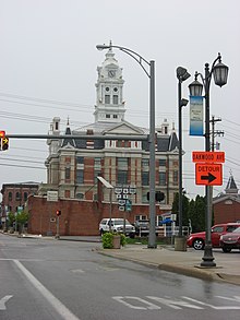
742:
736:
666:
660:
628:
622:
615:
609:
602:
596:
560:
554:
547:
541:
534:
528:
521:
515:
492:
463:
355:. SR 424 entered the village of
222:
207:
93:
38:
24:
712:Defiance–Henry County Line Road
1339:"The beginning and end of 424"
1309:1969 Official Ohio Highway Map
1054:1962 Official Ohio Highway Map
1:
1390:Former state highways in Ohio
577:south (Second Street) /
322:Indiana Northeastern Railroad
45:
869:Eastern terminus (1969–2012)
715:Western terminus (2008–2012)
481:Western terminus (1964–2008)
395:The former SR 424 in Florida
346:Independence Dam State Park
1421:
764:Western terminus of SR 110
381:folded diamond interchange
1282:1967 Official Highway Map
1086:Ohio Official Highway Map
873:
868:
862:
855:
809:
776:
768:
763:
761:east (North Perry Street)
732:
724:
719:
714:
708:
694:
683:
678:
655:
591:
510:
488:
480:
459:
451:
446:
441:
438:
435:
432:
429:
426:
263:that ran parallel to the
247:) was an east–west
200:
171:Ohio State Highway System
167:
158:
119:
60:
37:
892:
880:
305:Henry County Courthouse
1208:(Map). ODOT. June 2012
1156:(Map). ODOT. June 2012
1119:"Ohio State Route 424"
396:
308:
271:between the cities of
1002:on September 27, 2004
394:
302:
969:KML is from Wikidata
269:Miami and Erie Canal
1150:Defiance County Map
420:Major intersections
409:Fort Wayne, Indiana
676:(Domersville Road)
403:As the project to
397:
309:
906:
905:
897:Incomplete access
353:Flatrock Township
342:Richland Township
295:Route description
238:
237:
234:
233:
56:Route information
1412:
1375:
1369:
1363:
1362:
1360:
1358:
1353:on April 9, 2009
1352:
1347:. Archived from
1334:
1325:
1324:
1322:
1320:
1314:
1304:
1298:
1297:
1295:
1293:
1287:
1277:
1271:
1270:
1268:
1266:
1260:
1252:
1243:
1242:
1240:
1238:
1232:
1224:
1218:
1217:
1215:
1213:
1207:
1202:Henry County Map
1197:
1191:
1190:
1188:
1186:
1181:
1172:
1166:
1165:
1163:
1161:
1155:
1145:
1136:
1135:
1133:
1131:
1115:
1102:
1101:
1099:
1097:
1091:
1081:
1070:
1069:
1067:
1065:
1059:
1049:
1040:
1039:
1037:
1035:
1030:
1021:
1012:
1011:
1009:
1007:
1001:
995:. Archived from
994:
982:
959:
931:
928:
922:
919:
899:
893:
888:
881:
838:
837:
836:
831:
830:
825:
824:
823:
818:
817:
792:
791:
790:
785:
784:
770:Liberty Township
753:
752:
751:
746:
745:
740:
739:
671:
670:
669:
664:
663:
633:
632:
631:
626:
625:
620:
619:
618:
613:
612:
607:
606:
605:
600:
599:
565:
564:
563:
558:
557:
552:
551:
550:
545:
544:
539:
538:
537:
532:
531:
526:
525:
524:
519:
518:
496:
495:
467:
466:
424:
370:Liberty Township
230:
226:
225:
215:
211:
210:
202:
97:
96:
50:
47:
42:
28:
19:
1420:
1419:
1415:
1414:
1413:
1411:
1410:
1409:
1380:
1379:
1378:
1370:
1366:
1356:
1354:
1336:
1335:
1328:
1318:
1316:
1312:
1306:
1305:
1301:
1291:
1289:
1285:
1279:
1278:
1274:
1264:
1262:
1258:
1254:
1253:
1246:
1236:
1234:
1230:
1226:
1225:
1221:
1211:
1209:
1205:
1199:
1198:
1194:
1184:
1182:
1179:
1174:
1173:
1169:
1159:
1157:
1153:
1147:
1146:
1139:
1129:
1127:
1117:
1116:
1105:
1095:
1093:
1089:
1083:
1082:
1073:
1063:
1061:
1057:
1051:
1050:
1043:
1033:
1031:
1028:
1023:
1022:
1015:
1005:
1003:
999:
992:
984:
983:
974:
970:
967:
962:
961:
960:
944:
940:
935:
934:
929:
925:
920:
916:
911:
902:
895:
891:
883:
879:
875:
834:
832:
828:
826:
821:
819:
815:
813:
788:
786:
782:
780:
749:
747:
743:
741:
737:
702:
691:
667:
665:
661:
659:
629:
627:
623:
621:
616:
614:
610:
608:
603:
601:
597:
595:
561:
559:
555:
553:
548:
546:
542:
540:
535:
533:
529:
527:
522:
520:
516:
514:
493:
464:
422:
389:
330:State Routes 15
297:
281:Defiance County
241:State Route 424
223:
221:
208:
206:
94:
85:Major junctions
51:
48:
33:
32:
31:State Route 424
29:
17:
12:
11:
5:
1418:
1416:
1408:
1407:
1402:
1397:
1392:
1382:
1381:
1377:
1376:
1364:
1326:
1299:
1272:
1244:
1219:
1192:
1167:
1137:
1103:
1071:
1041:
1013:
971:
943:
942:
941:
939:
936:
933:
932:
923:
913:
912:
910:
907:
904:
903:
901:
900:
889:
876:
871:
870:
867:
864:
861:
857:
856:
854:
811:
808:
804:
803:
800:
778:
775:
772:
766:
765:
762:
734:
731:
728:
723:
717:
716:
713:
710:
707:
704:
693:
681:
680:
677:
657:
654:
650:
649:
646:
593:
590:
586:
585:
582:
512:
509:
505:
504:
501:
490:
487:
483:
482:
479:
473:Fort Wayne, IN
461:
458:
455:
450:
444:
443:
440:
437:
434:
431:
428:
421:
418:
388:
385:
296:
293:
236:
235:
232:
231:
218:
216:
198:
197:
196:
195:
190:
185:
180:
174:
173:
165:
164:
163:Highway system
160:
159:
156:
155:
150:
146:
145:
140:
136:
135:
130:
126:
125:
121:
120:
117:
116:
112:Dead end near
110:
106:
105:
91:
87:
86:
82:
81:
78:
74:
73:
70:
66:
65:
61:Maintained by
58:
57:
53:
52:
44:Map of SR 424
43:
35:
34:
30:
23:
22:
15:
13:
10:
9:
6:
4:
3:
2:
1417:
1406:
1405:U.S. Route 24
1403:
1401:
1398:
1396:
1393:
1391:
1388:
1387:
1385:
1373:
1368:
1365:
1351:
1346:
1345:
1344:Crescent-News
1340:
1333:
1331:
1327:
1319:September 22,
1311:
1310:
1303:
1300:
1292:September 22,
1284:
1283:
1276:
1273:
1257:
1251:
1249:
1245:
1229:
1223:
1220:
1204:
1203:
1196:
1193:
1178:
1171:
1168:
1152:
1151:
1144:
1142:
1138:
1126:
1125:
1120:
1114:
1112:
1110:
1108:
1104:
1088:
1087:
1080:
1078:
1076:
1072:
1056:
1055:
1048:
1046:
1042:
1027:
1020:
1018:
1014:
998:
991:
987:
981:
979:
977:
973:
966:
957:
953:
949:
948:
937:
927:
924:
918:
915:
908:
898:
890:
886:
878:
877:
872:
858:
853:
849:
845:
841:
805:
799:
798:Bowling Green
795:
771:
767:
760:
756:
727:
722:
718:
703:township line
701:
697:
690:
686:
682:
675:
651:
644:
640:
637:north /
636:
587:
580:
576:
572:
569:south /
568:
506:
499:
484:
478:
474:
470:
454:
449:
445:
425:
419:
417:
414:
410:
406:
401:
393:
386:
384:
382:
377:
375:
371:
367:
363:
358:
354:
349:
347:
343:
339:
335:
331:
327:
323:
319:
315:
306:
303:Photo of the
301:
294:
292:
290:
286:
282:
278:
274:
270:
266:
262:
258:
254:
250:
249:state highway
246:
242:
229:
219:
217:
214:
204:
203:
199:
194:
191:
189:
186:
184:
181:
179:
176:
175:
172:
169:
168:
166:
161:
157:
154:
151:
147:
144:
141:
137:
134:
133:United States
131:
127:
122:
118:
115:
111:
109:East end
107:
104:
100:
92:
90:West end
88:
83:
79:
75:
71:
67:
64:
59:
54:
41:
36:
27:
20:
1367:
1355:. Retrieved
1350:the original
1342:
1317:. Retrieved
1308:
1302:
1290:. Retrieved
1281:
1275:
1265:September 2,
1263:. Retrieved
1237:December 30,
1235:. Retrieved
1222:
1212:December 30,
1210:. Retrieved
1201:
1195:
1185:December 30,
1183:. Retrieved
1170:
1160:December 30,
1158:. Retrieved
1149:
1130:December 30,
1128:. Retrieved
1122:
1096:September 2,
1094:. Retrieved
1085:
1064:September 2,
1062:. Retrieved
1053:
1034:December 30,
1032:. Retrieved
1006:December 30,
1004:. Retrieved
997:the original
945:
926:
917:
894:
882:
840:SR 424C
796:east –
641:west /
573:east /
439:Destinations
402:
398:
378:
373:
350:
310:
285:Henry County
265:Maumee River
244:
240:
239:
170:
1124:Google Maps
885:Concurrency
759:SR 110
755:SR 108
692:county line
674:SR 281
579:SR 111
498:SR 111
228:SR 430
213:SR 423
49: 2008
1384:Categories
938:References
848:US 24
643:SR 66
639:SR 18
635:SR 15
575:SR 66
571:SR 18
567:SR 15
469:US 24
253:U.S. state
178:Interstate
99:US 24
844:US 6
794:US 6
80:1964–2012
1357:April 6,
947:KML file
887:terminus
866:Dead end
850: –
846: /
842:west to
757: /
726:Napoleon
700:Flatrock
696:Richland
685:Defiance
477:Napoleon
471: –
453:Defiance
448:Defiance
430:Location
407:between
374:SR 424-C
277:Napoleon
273:Defiance
149:Counties
124:Location
114:Napoleon
103:Defiance
1313:(MrSID)
1286:(MrSID)
1121:(Map).
1090:(MrSID)
1058:(MrSID)
387:History
357:Florida
129:Country
77:Existed
1175:ODOT.
1024:ODOT.
852:Toledo
427:County
413:Toledo
366:SR 110
362:SR 108
338:SR 281
326:SR 111
318:SR 111
245:SR 424
193:Scenic
69:Length
1259:(PDF)
1231:(PDF)
1206:(PDF)
1180:(PDF)
1154:(PDF)
1029:(PDF)
1000:(PDF)
993:(PDF)
909:Notes
863:41.47
860:25.77
810:40.31
807:25.05
777:39.96
774:24.83
733:33.73
730:20.96
721:Henry
709:18.09
706:11.24
689:Henry
442:Notes
314:SR 66
261:US 24
188:State
153:Henry
139:State
1359:2009
1321:2013
1294:2013
1267:2013
1239:2013
1214:2013
1187:2013
1162:2013
1132:2013
1098:2013
1066:2013
1036:2013
1008:2013
956:help
952:edit
656:9.29
653:5.77
592:6.00
589:3.73
581:ends
511:5.62
508:3.49
489:5.50
486:3.42
460:0.00
457:0.00
411:and
316:and
289:US 6
275:and
267:and
257:Ohio
143:Ohio
63:ODOT
672:To
255:of
101:in
1386::
1341:.
1329:^
1247:^
1140:^
1106:^
1074:^
1044:^
1016:^
988:.
975:^
954:•
475:,
436:km
433:mi
334:18
332:,
220:→
205:←
183:US
46:c.
1361:.
1323:.
1296:.
1269:.
1241:.
1216:.
1189:.
1164:.
1134:.
1100:.
1068:.
1038:.
1010:.
958:)
950:(
698:–
687:–
283:/
243:(
Text is available under the Creative Commons Attribution-ShareAlike License. Additional terms may apply.