265:
652:
40:
639:
604:
558:
507:
477:
448:
26:
700:
571:
694:
413:
248:
233:
126:
86:
706:
645:
610:
577:
564:
535:
513:
483:
454:
107:
658:
363:
was part of mainline US 30. State Route 430 was designated circa 1960 after US 30 was rerouted to its current location in the northern parts of
Mansfield and Ontario and the western terminus of US 30S was changed to the what is now the junction of US 30 and SR 309. No changes of major significance
973:
978:
944:
625:
332:
681:
201:
798:
871:
774:
53:
893:
862:
968:
778:
807:
211:
206:
953:
983:
714:
585:
581:
538:
487:
395:
356:
352:
344:
324:
172:
110:
710:
676:
416:
328:
308:
300:
273:
251:
236:
176:
129:
89:
662:
614:
517:
458:
835:
745:
733:
935:
269:
216:
811:
434:
424:
114:
962:
666:
400:
360:
348:
312:
304:
292:
152:
133:
93:
420:
264:
347:
through the
Mansfield area. The section of SR 430 from its western terminus in
359:, while the portion from US 42 to the eastern terminus at SR 603 just west of
39:
429:
Partial interchange, no access from SR 309 westbound to SR 430 eastbound
299:. The western terminus of State Route 430 is at an interchange with
331:
Counties. No part of State Route 430 is included as a part of the
635:
600:
554:
532:
473:
263:
25:
943:
296:
162:
410:
723:
1.000 mi = 1.609 km; 1.000 km = 0.621 mi
355:
in eastern
Mansfield follows the original western end of
931:
926:
670:
619:
589:
543:
492:
343:
State Route 430 follows part of what was previously
307:. Its eastern terminus is at a T-intersection with
428:
186:
168:
158:
148:
143:
120:
99:
80:
75:
67:
59:
46:
21:
364:have taken place to SR 430 since its inception.
901:(Map). Ohio Department of Transportation. 1961
8:
323:This state highway runs through portions of
779:"Technical Services Straight Line Diagrams"
544:Western end of northbound US 42 concurrency
493:Western end of southbound US 42 concurrency
945:Template:Attached KML/Ohio State Route 430
371:
225:
948:
974:Transportation in Richland County, Ohio
763:
979:Transportation in Ashland County, Ohio
18:
769:
767:
691:
685:
629:
594:
548:
526:
503:
497:
467:
444:
438:
404:
7:
843:(Map). Richland County Auditor. 1940
864:Ohio Official Highway Map 1959–1960
837:Plat Book of Richland County, Ohio
63:13.08 mi (21.05 km)
16:State highway in northern Ohio, US
14:
872:Ohio Department of Transportation
775:Ohio Department of Transportation
704:
698:
692:
671:Eastern end of SR 39 concurrency
656:
650:
643:
637:
620:Western end of SR 39 concurrency
608:
602:
590:Eastern end of US 42 concurrency
575:
569:
562:
556:
533:
511:
505:
481:
475:
452:
446:
411:
246:
231:
124:
105:
84:
38:
24:
954:State Route 430 Endpoint Photos
810:. December 2003. Archived from
895:1961 Ohio Official Highway Map
808:Federal Highway Administration
1:
800:National Highway System: Ohio
351:at SR 309 to its split from
295:in the northern portion of
1000:
419:(Park Avenue West) –
272:from the SR 430 bridge in
722:
718:
688:
680:
675:
632:
624:
597:
551:
529:
522:
500:
470:
463:
441:
433:
407:
399:
394:
389:
386:
383:
380:
377:
374:
224:
195:Ohio State Highway System
191:
182:
139:
51:
37:
741:
729:
584:north (Ashland Road) to
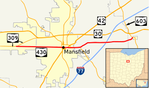
291:) is an east–west
617:north (East 5th Street)
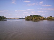
461:south (Mulberry Street)
333:National Highway System
969:State highways in Ohio
665:south (Lucas Road) to
520:north (Diamond Street)
277:
267:
949:KML is from Wikidata
817:on October 16, 2008
490:south (Main Street)
368:Major intersections
101:Major intersections
278:
755:
754:
746:Incomplete access
319:Route description
270:Charles Mill Lake
262:
261:
258:
257:
47:Route information
991:
939:
911:
910:
908:
906:
900:
890:
884:
883:
881:
879:
869:
859:
853:
852:
850:
848:
842:
832:
826:
825:
823:
822:
816:
805:
795:
789:
788:
786:
785:
771:
748:
742:
737:
730:
709:
708:
707:
702:
701:
696:
695:
682:Mifflin Township
661:
660:
659:
654:
653:
648:
647:
646:
641:
640:
626:Madison Township
613:
612:
611:
606:
605:
580:
579:
578:
573:
572:
567:
566:
565:
560:
559:
537:
536:
516:
515:
514:
509:
508:
486:
485:
484:
479:
478:
457:
456:
455:
450:
449:
415:
414:
372:
276:, looking north.
254:
250:
249:
239:
235:
234:
226:
128:
127:
109:
108:
102:
88:
87:
42:
28:
19:
999:
998:
994:
993:
992:
990:
989:
988:
959:
958:
950:
947:
942:
941:
940:
924:
920:
915:
914:
904:
902:
898:
892:
891:
887:
877:
875:
867:
861:
860:
856:
846:
844:
840:
834:
833:
829:
820:
818:
814:
803:
797:
796:
792:
783:
781:
773:
772:
765:
760:
751:
744:
740:
732:
728:
724:
705:
703:
699:
697:
693:
657:
655:
651:
649:
644:
642:
638:
636:
609:
607:
603:
601:
576:
574:
570:
568:
563:
561:
557:
555:
534:
512:
510:
506:
504:
482:
480:
476:
474:
453:
451:
447:
445:
412:
370:
341:
321:
309:State Route 603
301:State Route 309
281:State Route 430
247:
245:
232:
230:
125:
106:
100:
85:
76:Major junctions
33:
32:
31:State Route 430
29:
17:
12:
11:
5:
997:
995:
987:
986:
981:
976:
971:
961:
960:
957:
956:
923:
922:
921:
919:
918:External links
916:
913:
912:
885:
854:
827:
790:
762:
761:
759:
756:
753:
752:
750:
749:
738:
725:
720:
719:
717:
690:
687:
684:
679:
673:
672:
669:
634:
631:
628:
622:
621:
618:
599:
596:
592:
591:
588:
553:
550:
546:
545:
542:
541:(Adams Street)
531:
528:
524:
523:
521:
502:
499:
495:
494:
491:
472:
469:
465:
464:
462:
443:
440:
437:
431:
430:
427:
409:
406:
403:
398:
392:
391:
388:
385:
382:
379:
376:
369:
366:
340:
337:
320:
317:
274:Ashland County
260:
259:
256:
255:
242:
240:
222:
221:
220:
219:
214:
209:
204:
198:
197:
189:
188:
187:Highway system
184:
183:
180:
179:
170:
166:
165:
160:
156:
155:
150:
146:
145:
141:
140:
137:
136:
122:
118:
117:
103:
97:
96:
82:
78:
77:
73:
72:
69:
65:
64:
61:
57:
56:
52:Maintained by
49:
48:
44:
43:
35:
34:
30:
23:
22:
15:
13:
10:
9:
6:
4:
3:
2:
996:
985:
984:U.S. Route 30
982:
980:
977:
975:
972:
970:
967:
966:
964:
955:
952:
951:
946:
937:
933:
929:
928:
917:
897:
896:
889:
886:
873:
866:
865:
858:
855:
839:
838:
831:
828:
813:
809:
802:
801:
794:
791:
780:
776:
770:
768:
764:
757:
747:
739:
735:
727:
726:
721:
716:
712:
683:
678:
674:
668:
664:
627:
623:
616:
593:
587:
583:
547:
540:
525:
519:
496:
489:
466:
460:
436:
432:
426:
422:
418:
402:
397:
393:
373:
367:
365:
362:
358:
354:
350:
346:
338:
336:
334:
330:
326:
318:
316:
314:
311:just outside
310:
306:
302:
298:
294:
293:state highway
290:
286:
282:
275:
271:
266:
253:
243:
241:
238:
228:
227:
223:
218:
215:
213:
210:
208:
205:
203:
200:
199:
196:
193:
192:
190:
185:
181:
178:
174:
171:
167:
164:
161:
157:
154:
153:United States
151:
147:
142:
138:
135:
131:
123:
121:East end
119:
116:
112:
104:
98:
95:
91:
83:
81:West end
79:
74:
70:
66:
62:
58:
55:
50:
45:
41:
36:
27:
20:
925:
903:. Retrieved
894:
888:
876:. Retrieved
863:
857:
845:. Retrieved
836:
830:
819:. Retrieved
812:the original
799:
793:
782:. Retrieved
743:
731:
387:Destinations
342:
322:
288:
284:
280:
279:
194:
71:1960–present
734:Concurrency
711:SR 603
417:SR 309
252:SR 435
237:SR 424
130:SR 603
90:SR 309
963:Categories
847:August 11,
821:2010-09-15
784:2008-03-16
758:References
715:US 30
663:SR 39
615:SR 39
586:US 30
582:US 42
539:US 42
518:SR 13
488:US 42
459:SR 13
268:A view of
202:Interstate
111:US 42
905:August 6,
878:August 6,
435:Mansfield
425:Mansfield
115:Mansfield
927:KML file
736:terminus
396:Richland
378:Location
325:Richland
173:Richland
169:Counties
144:Location
870:(Map).
806:(Map).
677:Ashland
401:Ontario
361:Mifflin
349:Ontario
339:History
329:Ashland
313:Mifflin
305:Ontario
177:Ashland
149:Country
134:Mifflin
94:Ontario
68:Existed
874:. 1959
421:Galion
375:County
357:US 30S
289:OH 430
285:SR 430
217:Scenic
60:Length
899:(PDF)
868:(PDF)
841:(PDF)
815:(PDF)
804:(PDF)
689:21.05
686:13.08
633:11.20
390:Notes
353:US 42
345:US 30
212:State
159:State
132:near
936:help
932:edit
907:2020
880:2020
849:2020
667:I-71
630:6.96
598:9.59
595:5.96
552:9.06
549:5.63
530:8.63
527:5.36
501:8.26
498:5.13
471:8.14
468:5.06
442:7.92
439:4.92
408:0.00
405:0.00
327:and
297:Ohio
163:Ohio
54:ODOT
713:to
303:in
113:in
92:in
965::
934:•
777:.
766:^
423:,
384:km
381:mi
335:.
315:.
287:,
244:→
229:←
207:US
175:,
938:)
930:(
909:.
882:.
851:.
824:.
787:.
283:(
Text is available under the Creative Commons Attribution-ShareAlike License. Additional terms may apply.