461:
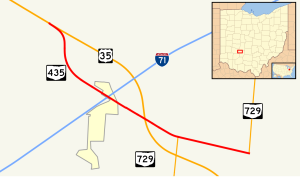
built between the freeway just northwest of I-71 and the former routing of US 35. From this point to the easternmost point of the SR 729 overlap of the previous routing of US 35, the old routing of US 35 was kept in the state highway system. The connector, along with this portion of former US 35, was assigned the SR 435 designation. This allowed for not only a connection between I-71 and the new US 35 freeway, but also SR 729 and the freeway.
251:
40:
883:
869:
745:
712:
764:
674:
594:
26:
999:
758:
751:
718:
236:
136:
770:
680:
600:
117:
86:
635:
107:
460:
was moved onto a new freeway alignment in 2003. Consequently, the majority of the former two-lane routing was removed from the state highway system. However, the re-routing resulted in there being no direct connection between US 35 and I-71 at Octa. To alleviate this, a new connector was
444:, between Allen Road and West Lancaster Road. The route intersects Factory Shops Boulevard, which leads to a shopping center. Then, SR 435 passes over US 35 again, and soon becomes concurrent with SR 729. A mile later, the concurrency ends, and SR 435 ends at SR 729.
317:
This route follows a former alignment of US 35, which now bypasses this area along a freeway alignment. SR 435 provides access between current U.S. Route 35 and
1135:
537:, its centerline was 1-mile (1.6 km) east of State Route 43. However, the plan was never implemented beyond the planning stages. Instead, the city of
857:
656:
580:
613:
Partial interchange; access provided from US 35 eastbound to SR 435 eastbound and from SR 435 westbound to US 35 westbound only
430:
698:
204:
962:
909:
53:
440:
at US 35, and passes through farmland. The route moves southwest and meets the old routing of US 35. SR 435 crosses over I-71 at a
1130:
693:
Partial interchange; access provided from SR 435 to US 35 eastbound and from US 35 westbound to SR 435 only
433:(NHS). The NHS is a network of routes identified as being most important for the economy, mobility and defense of the nation.
913:
971:
937:
786:
688:
457:
214:
209:
437:
542:
1140:
778:
684:
604:
494:
120:
89:
782:
774:
722:
554:
522:
518:
514:
510:
506:
502:
498:
490:
486:
470:
426:
318:
307:
299:
295:
254:
239:
179:
139:
726:
534:
530:
482:
478:
441:
311:
291:
124:
818:
806:
526:
474:
1077:
1035:
888:
848:
219:
646:
975:
1114:
Pages include a 1975 highway map and a 1974 highway plan for
Portage and Summit Counties.
1068:
1026:
1076:(Map) (2003–2004 ed.). c. 1:570,240. Columbus: Ohio Department of Transportation.
1034:(Map) (2001–2002 ed.). c. 1:570,240. Columbus: Ohio Department of Transportation.
642:
477:, as a result of a regional planning report. Connections in Portage would have been at
303:
1124:
1109:
638:
279:
159:
110:
941:
1004:
874:
608:
453:
864:
618:
538:
283:
93:
545:
expanded SR 43 from two lanes to four to provide better access to I-76.
469:
SR 435 was once a proposed limited-access north–south highway in
425:
The entirety of SR 435 is nestled within the northwestern quadrant of
39:
1085:
1047:
1043:
1081:
1039:
741:
708:
321:(I-71), as no direct interchange exists between the two highways.
298:(US 35) approximately 5.50 miles (8.85 km) southwest of
25:
856:
411:
287:
169:
1112:: Portage County Historical Society. 1978. pp. K-23, K-25.
670:
590:
796:
1.000 mi = 1.609 km; 1.000 km = 0.621 mi
844:
839:
278:) is a 4.084-mile (6.573 km) long east–west
790:
730:
940:. Ohio Department of Transportation. Archived from
692:
612:
189:
175:
165:
155:
150:
130:
99:
80:
75:
67:
59:
46:
21:
1067:Ohio Department of Transportation (January 2003).
429:. This highway is not included as a part of the
1025:Ohio Department of Transportation (June 2001).
290:. The western terminus of SR 435 is at a
1106:1874–1978 Bicentennial Atlas of Portage County
914:"Technical Services DESTAPE - Fayette County"
8:
904:
902:
900:
938:"Transportation Information Mapping System"
858:Template:Attached KML/Ohio State Route 435
559:
497:. Connections in Stark would have been at
328:
310:nearly 2 miles (3.2 km) northeast of
228:
861:
16:State highway in Fayette County, Ohio, US
777:north / CR 35A east (Old US 35) to
896:
1136:Transportation in Fayette County, Ohio
18:
735:
702:
660:
632:
622:
584:
7:
529:. Designed to relieve traffic from
282:in the southwestern portion of the
330:Traffic volume on State Route 435
63:4.084 mi (6.573 km)
14:
910:Ohio Department of Transportation
791:Eastern end of SR 729 concurrency
731:Western end of SR 729 concurrency
1070:Official Ohio Transportation Map
1028:Official Ohio Transportation Map
881:
867:
768:
762:
756:
749:
743:
716:
710:
678:
672:
633:
598:
592:
302:, and its eastern terminus is a
249:
234:
134:
115:
105:
84:
38:
24:
974:. December 2003. Archived from
436:SR 435 starts at an incomplete
972:Federal Highway Administration
1:
964:National Highway System: Ohio
521:and would have terminated at
465:Northeast Ohio former plans
1157:
795:
738:
705:
697:
665:
655:
650:
627:
617:
587:
579:
574:
571:
568:
565:
562:
438:directional T interchange
406:
337:
334:
227:
198:Ohio State Highway System
194:
185:
146:
51:
37:
814:
802:
553:The entire route is in
431:National Highway System
1131:State highways in Ohio
1000:"Ohio State Route 435"
787:Washington Court House
689:Washington Court House
458:Washington Court House
862:KML is from Wikidata
268:State Route 435
981:on October 16, 2008
549:Major intersections
501:, State Street NE,
452:US 35 between
442:diamond interchange
331:
292:partial interchange
101:Major intersections
657:Jefferson Township
581:Jefferson Township
543:Brimfield Township
329:
142:near Milledgeville
889:U.S. Roads portal
828:
827:
819:Incomplete access
423:
422:
335:County Log Point
325:Route description
265:
264:
261:
260:
47:Route information
1148:
1115:
1113:
1102:
1096:
1095:
1093:
1092:
1075:
1064:
1058:
1057:
1055:
1054:
1033:
1022:
1016:
1015:
1013:
1012:
996:
990:
989:
987:
986:
980:
969:
959:
953:
952:
950:
949:
933:
927:
926:
924:
923:
918:
906:
891:
886:
885:
884:
877:
872:
871:
870:
852:
821:
815:
810:
803:
773:
772:
771:
766:
765:
760:
759:
754:
753:
752:
747:
746:
721:
720:
719:
714:
713:
683:
682:
681:
676:
675:
637:
636:
603:
602:
601:
596:
595:
560:
332:
257:
253:
252:
242:
238:
237:
229:
138:
137:
119:
118:
109:
108:
102:
88:
87:
42:
28:
19:
1156:
1155:
1151:
1150:
1149:
1147:
1146:
1145:
1121:
1120:
1119:
1118:
1104:
1103:
1099:
1090:
1088:
1073:
1066:
1065:
1061:
1052:
1050:
1031:
1024:
1023:
1019:
1010:
1008:
998:
997:
993:
984:
982:
978:
967:
961:
960:
956:
947:
945:
935:
934:
930:
921:
919:
916:
908:
907:
898:
887:
882:
880:
873:
868:
866:
863:
860:
855:
854:
853:
837:
833:
824:
817:
813:
805:
801:
797:
769:
767:
763:
761:
757:
755:
750:
748:
744:
742:
717:
715:
711:
709:
699:Jasper Township
679:
677:
673:
671:
667:
662:
634:
629:
624:
599:
597:
593:
591:
551:
467:
450:
419:
327:
250:
248:
235:
233:
135:
116:
114:
106:
100:
85:
76:Major junctions
33:
32:
31:State Route 435
29:
17:
12:
11:
5:
1154:
1152:
1144:
1143:
1138:
1133:
1123:
1122:
1117:
1116:
1097:
1059:
1017:
991:
954:
928:
895:
894:
893:
892:
878:
836:
835:
834:
832:
829:
826:
825:
823:
822:
811:
798:
793:
792:
789:
783:Jeffersonville
740:
737:
733:
732:
729:
707:
704:
701:
695:
694:
691:
669:
664:
659:
653:
652:
651:Exit 65 (I-71)
649:
631:
626:
621:
615:
614:
611:
589:
586:
583:
577:
576:
573:
570:
567:
564:
555:Fayette County
550:
547:
471:Portage County
466:
463:
449:
446:
427:Fayette County
421:
420:
418:
417:
414:
407:
404:
403:
400:
396:
395:
392:
388:
387:
384:
380:
379:
376:
372:
371:
368:
364:
363:
360:
356:
355:
352:
348:
347:
344:
340:
339:
336:
326:
323:
304:T-intersection
300:Jeffersonville
263:
262:
259:
258:
245:
243:
225:
224:
223:
222:
217:
212:
207:
201:
200:
192:
191:
190:Highway system
187:
186:
183:
182:
177:
173:
172:
167:
163:
162:
157:
153:
152:
148:
147:
144:
143:
132:
128:
127:
103:
97:
96:
82:
78:
77:
73:
72:
69:
65:
64:
61:
57:
56:
52:Maintained by
49:
48:
44:
43:
35:
34:
30:
23:
22:
15:
13:
10:
9:
6:
4:
3:
2:
1153:
1142:
1141:U.S. Route 35
1139:
1137:
1134:
1132:
1129:
1128:
1126:
1111:
1110:Ravenna, Ohio
1107:
1101:
1098:
1087:
1083:
1079:
1072:
1071:
1063:
1060:
1049:
1045:
1041:
1037:
1030:
1029:
1021:
1018:
1007:
1006:
1001:
995:
992:
977:
973:
966:
965:
958:
955:
944:on 2013-09-16
943:
939:
932:
929:
915:
911:
905:
903:
901:
897:
890:
879:
876:
865:
859:
850:
846:
842:
841:
830:
820:
812:
808:
800:
799:
794:
788:
784:
780:
776:
734:
728:
727:Milledgeville
725:south –
724:
700:
696:
690:
686:
658:
654:
648:
644:
640:
620:
616:
610:
606:
582:
578:
561:
558:
556:
548:
546:
544:
540:
536:
532:
528:
524:
520:
516:
512:
508:
504:
500:
496:
492:
488:
484:
480:
476:
472:
464:
462:
459:
455:
447:
445:
443:
439:
434:
432:
428:
415:
413:
409:
408:
405:
401:
398:
397:
393:
390:
389:
385:
382:
381:
377:
374:
373:
369:
366:
365:
361:
358:
357:
353:
350:
349:
345:
342:
341:
333:
324:
322:
320:
319:Interstate 71
315:
313:
312:Milledgeville
309:
305:
301:
297:
296:U.S. Route 35
293:
289:
285:
281:
280:state highway
277:
273:
269:
256:
246:
244:
241:
231:
230:
226:
221:
218:
216:
213:
211:
208:
206:
203:
202:
199:
196:
195:
193:
188:
184:
181:
178:
174:
171:
168:
164:
161:
160:United States
158:
154:
149:
145:
141:
133:
131:East end
129:
126:
125:Milledgeville
122:
112:
104:
98:
95:
91:
83:
81:West end
79:
74:
70:
66:
62:
58:
55:
50:
45:
41:
36:
27:
20:
1105:
1100:
1089:. Retrieved
1069:
1062:
1051:. Retrieved
1027:
1020:
1009:. Retrieved
1003:
994:
983:. Retrieved
976:the original
963:
957:
946:. Retrieved
942:the original
931:
920:. Retrieved
838:
816:
804:
781:west –
687:east –
607:west –
572:Destinations
552:
475:Stark County
468:
451:
435:
424:
316:
275:
271:
267:
266:
197:
71:2003–present
1005:Google Maps
875:Ohio portal
807:Concurrency
775:SR 729
723:SR 729
523:SR 183
515:SR 172
511:SR 153
503:SR 173
499:SR 619
495:US 224
487:SR 261
308:SR 729
276:OH 435
272:SR 435
255:SR 440
240:SR 430
140:SR 729
1125:Categories
1091:2015-06-18
1053:2015-06-18
1011:2015-06-18
985:2015-06-18
948:2015-06-18
922:2015-06-18
831:References
779:US 35
685:US 35
647:Cincinnati
605:US 35
535:SR 44
531:SR 43
519:US 30
507:US 62
483:SR 59
479:SR 14
284:U.S. state
205:Interstate
121:US 35
90:US 35
1086:31884639
1048:52954853
1044:31884639
840:KML file
809:terminus
643:Columbus
641: –
563:Location
416:Source:
410:Volume:
176:Counties
151:Location
1082:5673562
1040:5673562
1002:(Map).
970:(Map).
936:Staff.
448:History
378:13,500
370:16,380
338:Volume
180:Fayette
156:Country
113:in Octa
68:Existed
1080:
1038:
666:3.500–
661:2.175–
628:2.469–
623:1.534–
402:1,440
394:1,640
386:6,390
362:9,800
354:4,270
346:3,300
220:Scenic
60:Length
1074:(PDF)
1032:(PDF)
979:(PDF)
968:(PDF)
917:(PDF)
739:6.573
736:4.084
706:4.688
703:2.913
668:3.940
663:2.448
630:2.702
625:1.679
609:Xenia
575:Notes
527:Sandy
454:Xenia
399:2.922
391:2.562
375:1.787
359:1.404
306:with
294:with
215:State
166:State
123:near
92:near
1078:OCLC
1036:OCLC
849:help
845:edit
639:I-71
619:Octa
588:0.00
585:0.00
541:and
539:Kent
533:and
493:and
491:I-76
473:and
456:and
412:AADT
367:1.65
288:Ohio
170:Ohio
111:I-71
94:Octa
54:ODOT
525:in
383:2.0
351:0.8
343:0.5
314:.
286:of
1127::
1108:.
1084:,
1046:,
1042:,
912:.
899:^
847:•
785:,
645:,
569:km
566:mi
557:.
517:,
513:,
509:,
505:,
489:,
485:,
481:,
274:,
247:→
232:←
210:US
1094:.
1056:.
1014:.
988:.
951:.
925:.
851:)
843:(
270:(
Text is available under the Creative Commons Attribution-ShareAlike License. Additional terms may apply.