739:
51:
81:
34:
640:
88:
58:
435:
was the first to follow up on van der Stel's discovery. In 1852 he examined the old shafts, discovered some other copper outcrops and started mining operations. Prospectors, miners, and speculators rushed to the area, but many companies collapsed when the logistical difficulties became apparent.
430:
and brought along some pure copper. Van der Stel himself led a major expedition in 1685 and reached the fabled mountains on 21 October. Three shafts were sunk and revealed a rich lode of copper ore; the shafts exist to this day. For almost 200 years nothing was done about the discovery, largely
505:’ forces. The village of Concordia, with a garrison of 100 men, surrendered a day after the siege started. On 4 May 1902 a British relief column arrived from Port Nolloth and ended the siege. A ruined blockhouse is still visible on a hill north-east of the town.
584:
475:
508:
As with most metals, copper suffered mixed fortunes, and in the early 20th century, the copper price dropped below the profitable level, so that mining operations ceased, but were resumed when prices rose.
1011:
671:
518:
479:
618:
459:
and returning with equipment and provisions. The carriages were initially pulled by mules and horses, which were later replaced by steam locomotives — the last of these, the
738:
991:
570:
1006:
1001:
664:
1016:
50:
490:
447:. The ruins of the buildings they constructed, as well as the stonework of the bridges and culverts of the railway built to transport the ore to
113:
657:
33:
996:
335:
80:
382:, and was in the 1870s ranked as having the richest copper mine in the world. The town is on the site of a spring that was known in the
803:
360:
564:
649:
937:
599:
831:
750:
681:
225:
168:
945:
864:
178:
783:
494:
327:
816:
705:
922:
917:
877:
821:
696:
854:
498:
432:
849:
247:
452:
423:
262:
251:
415:
644:
383:
414:
heard rumors of mountains in the north-west that were fabulously rich in copper. Governor
348:
619:"History of the Okiep copper district: Namaqualand, Northern Cape Province South Africa"
950:
788:
728:
723:
486:
440:
300:
280:
985:
872:
763:
685:
468:
375:
158:
965:
456:
448:
379:
148:
545:
793:
768:
419:
411:
387:
960:
927:
844:
811:
128:
115:
882:
778:
713:
502:
427:
318:
289:
236:
639:
970:
907:
902:
897:
892:
887:
839:
718:
471:. The other principal mines of the area are at Carolusberg and Nababeep.
464:
444:
467:. Nowadays, road transport is used to convey the ore to the railhead at
773:
955:
758:
323:
443:, and brought with them the expertise of centuries of tin-mining in
474:
455:
started operating in 1876 and lasted for 68 years, carrying ore to
473:
653:
418:
was inclined to believe these tales when, in 1681, a group of
737:
38:
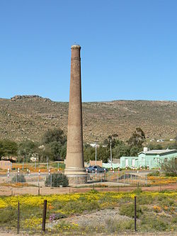
Ventilation shaft built by the Cape Copper
Company in 1880
497:, Namaqualand Border Scouts, the Town Guard, and the
1012:
519:
Cape Copper
Company Medal for the Defence of O'okiep
489:
when some 700 officers and men of the 3rd
Battalion
480:
Cape Copper
Company Medal for the Defence of O'okiep
936:
863:
830:
802:
749:
704:
485:Okiep’s mine saw action on 4 April 1902 during the
359:
347:
334:
317:
309:
298:
287:
279:
271:
260:
245:
234:
223:
218:
210:
202:
197:
189:
184:
174:
164:
154:
144:
21:
571:Human Sciences Research Council (South Africa)
665:
431:because of its remote location. The explorer
8:
540:
538:
536:
534:
672:
658:
650:
566:Dictionary of Southern African Place Names
18:
530:
346:
333:
316:
278:
217:
196:
183:
143:
108:
42:
30:
992:1852 establishments in the Cape Colony
600:"Reviving a historic mining district"
598:Tassell, Arthur (15 September 2023).
358:
308:
297:
286:
270:
259:
244:
233:
222:
209:
201:
193:38.63 km (14.92 sq mi)
188:
173:
163:
153:
7:
1007:Populated places established in 1852
742:Namakwa District within South Africa
16:Place in Northern Cape, South Africa
1002:Mining communities in South Africa
680:Municipalities and communities of
14:
1017:Underground mines in South Africa
617:Cairncross, Bruce (1 July 2004).
638:
398:) and was originally spelled as
86:
79:
56:
49:
32:
1:
682:Namakwa District Municipality
585:"The O'okiep Copper District"
87:
57:
997:Copper mines in South Africa
501:withstood a 30-day siege by
495:Royal Warwickshire Regiment
1033:
735:
692:
451:, can still be seen. The
109:
70:Show map of Northern Cape
43:
31:
623:The Mineralogical Record
100:Show map of South Africa
499:Cape Garrison Artillery
374:is a small town in the
214:160/km (420/sq mi)
743:
491:Queen's Royal Regiment
482:
439:The first miners were
410:Early settlers in the
741:
647:at Wikimedia Commons
477:
129:29.59583°S 17.88083°E
563:Raper, R.E. (1989).
396:large brackish place
219:Racial makeup (2011)
211: • Density
625:. pp. 289–318.
453:Namaqualand Railway
134:-29.59583; 17.88083
125: /
744:
546:"Main Place Okiep"
483:
416:Simon van der Stel
310: • Other
272: • Other
203: • Total
190: • Total
979:
978:
643:Media related to
384:Khoekhoe language
369:
368:
1024:
674:
667:
660:
651:
642:
627:
626:
614:
608:
607:
604:Miningreview.com
595:
589:
588:
581:
575:
574:
560:
554:
553:
542:
140:
139:
137:
136:
135:
130:
126:
123:
122:
121:
118:
101:
90:
89:
83:
71:
60:
59:
53:
36:
19:
1032:
1031:
1027:
1026:
1025:
1023:
1022:
1021:
982:
981:
980:
975:
932:
859:
826:
798:
745:
733:
700:
694:District seat:
688:
678:
636:
631:
630:
616:
615:
611:
597:
596:
592:
583:
582:
578:
562:
561:
557:
544:
543:
532:
527:
515:
433:James Alexander
408:
355:
343:
281:First languages
133:
131:
127:
124:
119:
116:
114:
112:
111:
105:
104:
103:
102:
99:
98:
97:
96:
95:
91:
74:
73:
72:
69:
68:
67:
66:
65:
61:
39:
27:
24:
17:
12:
11:
5:
1030:
1028:
1020:
1019:
1014:
1009:
1004:
999:
994:
984:
983:
977:
976:
974:
973:
968:
963:
958:
953:
951:Eksteenfontein
948:
942:
940:
934:
933:
931:
930:
925:
920:
915:
910:
905:
900:
895:
890:
885:
880:
875:
869:
867:
861:
860:
858:
857:
852:
847:
842:
836:
834:
828:
827:
825:
824:
819:
814:
808:
806:
804:Karoo Hoogland
800:
799:
797:
796:
791:
789:Soebatsfontein
786:
781:
776:
771:
766:
761:
755:
753:
747:
746:
736:
734:
732:
731:
729:Nieuwoudtville
726:
724:Loeriesfontein
721:
716:
710:
708:
702:
701:
693:
690:
689:
679:
677:
676:
669:
662:
654:
635:
634:External links
632:
629:
628:
609:
590:
576:
573:. p. 347.
555:
529:
528:
526:
523:
522:
521:
514:
511:
487:Anglo-Boer war
407:
404:
367:
366:
363:
357:
356:
353:
351:
345:
344:
341:
339:
332:
331:
321:
315:
314:
311:
307:
306:
303:
296:
295:
292:
285:
284:
277:
276:
273:
269:
268:
265:
258:
257:
254:
243:
242:
239:
232:
231:
228:
221:
220:
216:
215:
212:
208:
207:
204:
200:
199:
195:
194:
191:
187:
186:
182:
181:
176:
172:
171:
166:
162:
161:
156:
152:
151:
146:
142:
141:
107:
106:
93:
92:
85:
84:
78:
77:
76:
75:
63:
62:
55:
54:
48:
47:
46:
45:
44:
41:
40:
37:
29:
28:
25:
22:
15:
13:
10:
9:
6:
4:
3:
2:
1029:
1018:
1015:
1013:
1010:
1008:
1005:
1003:
1000:
998:
995:
993:
990:
989:
987:
972:
969:
967:
964:
962:
959:
957:
954:
952:
949:
947:
946:Alexander Bay
944:
943:
941:
939:
935:
929:
926:
924:
921:
919:
916:
914:
911:
909:
906:
904:
901:
899:
896:
894:
891:
889:
886:
884:
881:
879:
876:
874:
873:Buffelsrivier
871:
870:
868:
866:
862:
856:
853:
851:
848:
846:
843:
841:
838:
837:
835:
833:
829:
823:
820:
818:
815:
813:
810:
809:
807:
805:
801:
795:
792:
790:
787:
785:
782:
780:
777:
775:
772:
770:
767:
765:
764:Hondeklip Bay
762:
760:
757:
756:
754:
752:
748:
740:
730:
727:
725:
722:
720:
717:
715:
712:
711:
709:
707:
703:
699:
698:
691:
687:
686:Northern Cape
683:
675:
670:
668:
663:
661:
656:
655:
652:
648:
646:
641:
633:
624:
620:
613:
610:
605:
601:
594:
591:
586:
580:
577:
572:
568:
567:
559:
556:
551:
547:
541:
539:
537:
535:
531:
524:
520:
517:
516:
512:
510:
506:
504:
500:
496:
492:
488:
481:
476:
472:
470:
469:Bitterfontein
466:
462:
458:
454:
450:
446:
442:
437:
434:
429:
425:
421:
417:
413:
405:
403:
401:
397:
393:
389:
385:
381:
377:
376:Northern Cape
373:
364:
362:
352:
350:
340:
337:
329:
325:
322:
320:
312:
304:
302:
299: •
293:
291:
288: •
282:
274:
266:
264:
261: •
255:
253:
249:
246: •
240:
238:
235: •
229:
227:
226:Black African
224: •
213:
205:
192:
180:
177:
170:
167:
160:
159:Northern Cape
157:
150:
147:
138:
110:Coordinates:
82:
52:
35:
20:
966:Port Nolloth
938:Richtersveld
912:
784:Leliefontein
695:
637:
622:
612:
603:
593:
579:
565:
558:
549:
507:
484:
463:, stands at
460:
457:Port Nolloth
449:Port Nolloth
438:
422:visited the
409:
399:
395:
391:
380:South Africa
378:province of
371:
370:
175:Municipality
149:South Africa
794:Spoegrivier
769:Kamieskroon
550:Census 2011
412:Cape Colony
388:Nama people
336:Postal code
132: /
986:Categories
961:Lekkersing
928:Vioolsdrif
845:Onseepkans
817:Sutherland
812:Fraserburg
751:Kamiesberg
525:References
198:Population
120:17°52′51″E
117:29°35′45″S
923:Steinkopf
918:Springbok
883:Goodhouse
878:Concordia
865:Nama Khoi
822:Williston
779:Koingnaas
714:Brandvlei
697:Springbok
503:Jan Smuts
428:Cape Town
361:Area code
319:Time zone
290:Afrikaans
179:Nama Khoi
971:Sanddrif
908:Nababeep
903:Komaggas
898:Kleinzee
893:Henkries
888:Grootmis
855:Pofadder
840:Aggeneys
719:Calvinia
513:See also
465:Nababeep
445:Cornwall
338:(street)
237:Coloured
165:District
155:Province
832:Khâi-Ma
774:Karkams
441:Cornish
406:History
400:O'okiep
386:of the
169:Namakwa
145:Country
26:O'okiep
956:Kuboes
759:Garies
706:Hantam
493:, 5th
424:Castle
392:U-gieb
349:PO box
283:(2011)
248:Indian
913:Okiep
850:Pella
645:Okiep
461:Clara
420:Namas
372:Okiep
324:UTC+2
301:Xhosa
294:96.2%
263:White
252:Asian
241:93.8%
206:6,304
94:Okiep
64:Okiep
23:Okiep
478:The
354:8270
342:8270
328:SAST
313:2.7%
305:1.0%
275:1.0%
267:1.1%
256:0.3%
230:3.8%
185:Area
426:in
390:as
365:027
988::
684:,
621:.
602:.
569:.
548:.
533:^
402:.
673:e
666:t
659:v
606:.
587:.
552:.
394:(
330:)
326:(
250:/
Text is available under the Creative Commons Attribution-ShareAlike License. Additional terms may apply.