621:
79:
104:
62:
248:
111:
86:
266:
Designed by the
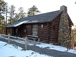
Architect Edward A. Nickel, NPS Branch of Plans and Design, and executed by the Civilian Conservation Corps (Camp NM-1, 6th Period), the fire hose house was constructed as ECW Project #17. Work was completed by August 10, 1937, "except for shelves," according to the hand-written note
243:
in 1935, the old administration building was used as the monument's headquarters and museum until 1959. At that time, headquarters was relocated while the building continued its function as the park's primary visitor center. Today the main level of the building serves as the visitor center; the
244:
basement level has public restrooms, museum storage, interpreter's office, library, storage for search and rescue and first aid equipment and supplies, and a fuel oil furnace. The upper level, originally designed for use as a bedroom, is now used for storage and houses an evaporative cooler.
721:
746:
741:
540:
698:
263:. The building first served as the residence of the monument's second custodian, George C. Crowe. The original structure had five rooms: living room, bedroom, breakfast nook kitchen, and bathroom.
731:
571:
271:. The fire hose house was designed and used to house the fire hydrant and to store the monument's hose and fire fighting equipment. It has been used for that purpose since 1937.
232:
includes three structures and their surroundings, including the old headquarters building, the custodian's house, and the fire hose house. The buildings are all designed in the
629:
508:
144:
654:
469:
726:
103:
736:
280:
702:
649:
674:
526:
78:
285:
564:
290:
592:
490:
48:
408:
390:
352:
557:
462:
580:
478:
315:
39:
620:
455:
644:
229:
447:
669:
233:
192:
255:
The custodian's residence was designed by the NPS Landscape
Division under the direction of Chief Landscape Architect
240:
549:
429:
61:
639:
260:
435:
584:
320:
132:
256:
600:
373:
National
Register of Historic Places Inventory-Nomination: Old Headquarters Area Historic District
684:
268:
334:
679:
441:
371:
521:
247:
664:
208:
715:
516:
722:
Park buildings and structures on the
National Register of Historic Places in Wyoming
482:
659:
541:
National
Register of Historic Places listings in Devils Tower National Monument
159:
146:
747:
Historic districts on the
National Register of Historic Places in Wyoming
610:
742:
National
Register of Historic Places in Devils Tower National Monument
699:
National
Register of Historic Places listings in Crook County, Wyoming
259:
and constructed in 1931 by a private contractor, a Mr. Cummings of
239:
Funded as an
Emergency Conservation Works project and built by the
246:
310:
553:
451:
110:
85:
341:. Wyoming State Preservation Office. November 8, 2008.
442:
628:
591:
507:
489:
214:
201:
191:
183:
175:
138:
127:
732:Buildings and structures in Crook County, Wyoming
444:at the Wyoming State Historic Preservation Office
432:Devils Tower First Fifty Years - The Early Years
655:Entrance Station—Devils Tower National Monument
281:Entrance Station-Devils Tower National Monument
703:List of National Historic Landmarks in Wyoming
565:
463:
8:
650:Entrance Road—Devils Tower National Monument
286:Entrance Road-Devils Tower National Monument
675:Tower Ladder—Devils Tower National Monument
291:Tower Ladder-Devils Tower National Monument
16:Historic district in Wyoming, United States
572:
558:
550:
470:
456:
448:
438:Devils Tower First Fifty Years - The 1930s
415:. National Park Service. November 8, 2008.
397:. National Park Service. November 8, 2008.
359:. National Park Service. November 8, 2008.
60:
335:"Old Headquarters Area Historic District"
40:U.S. National Register of Historic Places
727:National Park Service rustic in Wyoming
606:Old Headquarters Area Historic District
499:Old Headquarters Area Historic District
302:
32:Old Headquarters Area Historic District
737:Civilian Conservation Corps in Wyoming
311:"National Register Information System"
23:
7:
581:National Register of Historic Places
479:National Register of Historic Places
339:National Register of Historic Places
316:National Register of Historic Places
197:Devils Tower National Monument MPS
14:
660:McKean Archeological Site (48CK7)
619:
131:Devils Tower National Monument,
109:
102:
84:
77:
640:Arch Creek Petroglyphs (48CK41)
645:DXN Bridge over Missouri River
483:Devils Tower National Monument
370:Kathy McKoy (April 20, 2000).
230:Devils Tower National Monument
203:
1:
413:List of Classified Structures
395:List of Classified Structures
357:List of Classified Structures
353:"Old Administration Building"
118:Show map of the United States
670:Sundance State Bank Building
234:National Park Service Rustic
21:United States historic place
241:Civilian Conservation Corps
66:Old Administration Building
763:
693:
617:
535:
202:NRHP reference
71:
59:
55:
46:
37:
30:
26:
379:. National Park Service.
391:"Custodian's Residence"
261:Deadwood, South Dakota
252:
160:44.59056°N 104.72028°W
49:U.S. Historic district
585:Crook County, Wyoming
436:National Park Service
430:National Park Service
321:National Park Service
251:Custodian's Residence
250:
226:Old Headquarters Area
133:Devils Tower, Wyoming
257:Thomas Chalmers Vint
165:44.59056; -104.72028
601:Inyan Kara Mountain
269:architectural plans
156: /
93:Show map of Wyoming
685:Wyoming Mercantile
593:Historic districts
491:Historic districts
253:
709:
708:
680:Vore Buffalo Jump
547:
546:
409:"Fire Hose House"
323:. April 15, 2008.
222:
221:
754:
623:
574:
567:
560:
551:
522:Entrance Station
472:
465:
458:
449:
417:
416:
405:
399:
398:
387:
381:
380:
378:
367:
361:
360:
349:
343:
342:
331:
325:
324:
307:
205:
187:Edward A. Nickel
171:
170:
168:
167:
166:
161:
157:
154:
153:
152:
149:
119:
113:
112:
106:
94:
88:
87:
81:
64:
24:
762:
761:
757:
756:
755:
753:
752:
751:
712:
711:
710:
705:
689:
665:Sundance School
631:
624:
615:
587:
578:
548:
543:
531:
509:NRHP properties
503:
485:
476:
426:
421:
420:
407:
406:
402:
389:
388:
384:
376:
369:
368:
364:
351:
350:
346:
333:
332:
328:
309:
308:
304:
299:
277:
164:
162:
158:
155:
150:
147:
145:
143:
142:
123:
122:
121:
120:
117:
116:
115:
114:
97:
96:
95:
92:
91:
90:
89:
67:
51:
42:
33:
22:
17:
12:
11:
5:
760:
758:
750:
749:
744:
739:
734:
729:
724:
714:
713:
707:
706:
694:
691:
690:
688:
687:
682:
677:
672:
667:
662:
657:
652:
647:
642:
636:
634:
626:
625:
618:
616:
614:
613:
608:
603:
597:
595:
589:
588:
579:
577:
576:
569:
562:
554:
545:
544:
536:
533:
532:
530:
529:
524:
519:
513:
511:
505:
504:
502:
501:
495:
493:
487:
486:
477:
475:
474:
467:
460:
452:
446:
445:
439:
433:
425:
424:External links
422:
419:
418:
400:
382:
362:
344:
326:
301:
300:
298:
295:
294:
293:
288:
283:
276:
273:
220:
219:
216:
212:
211:
206:
199:
198:
195:
189:
188:
185:
181:
180:
177:
173:
172:
140:
136:
135:
129:
125:
124:
108:
107:
101:
100:
99:
98:
83:
82:
76:
75:
74:
73:
72:
69:
68:
65:
57:
56:
53:
52:
47:
44:
43:
38:
35:
34:
31:
28:
27:
20:
15:
13:
10:
9:
6:
4:
3:
2:
759:
748:
745:
743:
740:
738:
735:
733:
730:
728:
725:
723:
720:
719:
717:
704:
700:
697:
692:
686:
683:
681:
678:
676:
673:
671:
668:
666:
663:
661:
658:
656:
653:
651:
648:
646:
643:
641:
638:
637:
635:
633:
627:
622:
612:
609:
607:
604:
602:
599:
598:
596:
594:
590:
586:
582:
575:
570:
568:
563:
561:
556:
555:
552:
542:
539:
534:
528:
525:
523:
520:
518:
517:Entrance Road
515:
514:
512:
510:
506:
500:
497:
496:
494:
492:
488:
484:
480:
473:
468:
466:
461:
459:
454:
453:
450:
443:
440:
437:
434:
431:
428:
427:
423:
414:
410:
404:
401:
396:
392:
386:
383:
375:
374:
366:
363:
358:
354:
348:
345:
340:
336:
330:
327:
322:
318:
317:
312:
306:
303:
296:
292:
289:
287:
284:
282:
279:
278:
274:
272:
270:
264:
262:
258:
249:
245:
242:
237:
235:
231:
227:
218:July 20, 2000
217:
215:Added to NRHP
213:
210:
207:
200:
196:
194:
190:
186:
182:
178:
174:
169:
141:
137:
134:
130:
126:
105:
80:
70:
63:
58:
54:
50:
45:
41:
36:
29:
25:
19:
695:
605:
537:
527:Tower Ladder
498:
412:
403:
394:
385:
372:
365:
356:
347:
338:
329:
314:
305:
265:
254:
238:
225:
223:
18:
163: /
151:104°43′13″W
139:Coordinates
716:Categories
632:properties
297:References
148:44°35′26″N
696:See also:
538:See also:
184:Architect
630:Historic
275:See also
209:00000852
128:Location
611:Ranch A
267:on the
236:style.
377:(pdf)
176:Built
701:and
224:The
179:1931
583:in
481:in
228:at
204:No.
193:MPS
718::
411:.
393:.
355:.
337:.
319:.
313:.
573:e
566:t
559:v
471:e
464:t
457:v
Text is available under the Creative Commons Attribution-ShareAlike License. Additional terms may apply.