38:
55:
88:
500:
95:
62:
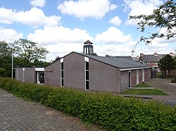
362:. It has been annexed and is now a neighbourhood with Hendrik-Ido-Ambacht. It used to have a harbour, but it was closed in 1950. In 1946, the Immanuel Chapel was built as emergency church. It was extensively modified in 1976. In 2000, the church was extended and the former day care centre was redesigned as
570:
541:
565:
580:
575:
267:
54:
585:
316:
The village was first mentioned in 1435 as "totten cleynen
Waldammen toe, die men heet op desen voorsz. tyt Dappers - dam", and means "eastern
279:
37:
534:
87:
123:
527:
259:
321:
363:
155:
238:
348:
248:
560:
359:
325:
511:
388:
335:. As it is currently a dead branch of the river, the locals commonly refer to it as the
554:
507:
310:
170:
499:
332:
298:
442:
160:
302:
180:
138:
125:
352:
229:
306:
468:
336:
294:
344:
255:
234:
329:
416:
317:
74:
Location in the province of South
Holland in the Netherlands
358:
A part of the village was located in the municipality of
515:
278:
266:
245:
228:
220:
212:
207:
199:
191:
186:
176:
166:
154:
21:
351:, which is largely occupied by the nearby city of
535:
423:(in Dutch). Het Waterschapshuis. 24 July 2019
8:
542:
528:
18:
571:Populated places established in the 1330s
375:
265:
227:
206:
198:
185:
153:
118:
46:
34:
383:
381:
379:
277:
244:
219:
211:
190:
175:
165:
16:Village in South Holland, Netherlands
7:
496:
494:
389:"Kerncijfers wijken en buurten 2021"
320:". The dam was founded in 1332 when
195:1.72 km (0.66 sq mi)
514:. You can help Knowledge (XXG) by
14:
566:Populated places in South Holland
443:"Oostendam - (geografische naam)"
94:
61:
581:Geography of Hendrik-Ido-Ambacht
498:
93:
86:
60:
53:
36:
421:Actueel Hoogtebestand Nederland
328:built around a side-arm of the
576:Economy of Hendrik-Ido-Ambacht
343:. Oostendam is located on the
1:
586:South Holland geography stubs
404:Stats are for Ridderkerk only
393:Central Bureau of Statistics
107:Location in the Netherlands
602:
493:
417:"Postcodetool for 2989AB"
119:
77:Show map of South Holland
47:
35:
28:
203:0.3 m (1.0 ft)
297:. It is located in the
224:360/km (930/sq mi)
110:Show map of Netherlands
510:location article is a
247: • Summer (
221: • Density
360:Hendrik-Ido-Ambacht
135: /
213: • Total
192: • Total
523:
522:
322:Count William III
288:
287:
593:
544:
537:
530:
502:
495:
485:
484:
482:
480:
465:
459:
458:
456:
454:
439:
433:
432:
430:
428:
413:
407:
406:
401:
399:
385:
252:
150:
149:
147:
146:
145:
140:
139:51.850°N 4.633°E
136:
133:
132:
131:
128:
111:
97:
96:
90:
78:
64:
63:
57:
40:
19:
601:
600:
596:
595:
594:
592:
591:
590:
551:
550:
549:
548:
491:
489:
488:
478:
476:
467:
466:
462:
452:
450:
441:
440:
436:
426:
424:
415:
414:
410:
397:
395:
387:
386:
377:
372:
274:
246:
143:
141:
137:
134:
129:
126:
124:
122:
121:
115:
114:
113:
112:
109:
108:
105:
104:
103:
102:
98:
81:
80:
79:
76:
75:
72:
71:
70:
69:
65:
43:
42:Immanuel Chapel
31:
24:
17:
12:
11:
5:
599:
597:
589:
588:
583:
578:
573:
568:
563:
553:
552:
547:
546:
539:
532:
524:
521:
520:
503:
487:
486:
460:
447:Etymologiebank
434:
408:
374:
373:
371:
368:
286:
285:
282:
276:
275:
272:
270:
264:
263:
253:
243:
242:
232:
226:
225:
222:
218:
217:
214:
210:
209:
205:
204:
201:
197:
196:
193:
189:
188:
184:
183:
178:
174:
173:
168:
164:
163:
158:
152:
151:
117:
116:
106:
100:
99:
92:
91:
85:
84:
83:
82:
73:
67:
66:
59:
58:
52:
51:
50:
49:
48:
45:
44:
41:
33:
32:
29:
26:
25:
22:
15:
13:
10:
9:
6:
4:
3:
2:
598:
587:
584:
582:
579:
577:
574:
572:
569:
567:
564:
562:
559:
558:
556:
545:
540:
538:
533:
531:
526:
525:
519:
517:
513:
509:
508:South Holland
504:
501:
497:
492:
474:
470:
464:
461:
448:
444:
438:
435:
422:
418:
412:
409:
405:
394:
390:
384:
382:
380:
376:
369:
367:
365:
361:
356:
354:
350:
346:
342:
338:
334:
331:
327:
323:
319:
314:
312:
311:South Holland
308:
305:, within the
304:
300:
296:
292:
283:
281:
271:
269:
261:
257:
254:
250:
240:
236:
233:
231:
223:
215:
202:
194:
182:
179:
172:
171:South Holland
169:
162:
159:
157:
148:
144:51.850; 4.633
120:Coordinates:
89:
56:
39:
27:
20:
516:expanding it
505:
490:
477:. Retrieved
473:Plaatsengids
472:
463:
451:. Retrieved
446:
437:
425:. Retrieved
420:
411:
403:
396:. Retrieved
392:
357:
340:
315:
299:municipality
290:
289:
280:Dialing code
177:Municipality
469:"Oosterdam"
349:IJsselmonde
341:Little Waal
293:is a Dutch
268:Postal code
161:Netherlands
142: /
561:Ridderkerk
555:Categories
475:(in Dutch)
449:(in Dutch)
370:References
364:consistory
339:, meaning
303:Ridderkerk
208:Population
181:Ridderkerk
353:Rotterdam
291:Oostendam
230:Time zone
200:Elevation
101:Oostendam
68:Oostendam
23:Oostendam
307:province
167:Province
337:Waaltje
295:village
156:Country
127:51°51′N
30:Village
345:island
130:4°38′E
506:This
479:3 May
453:3 May
427:3 May
398:3 May
330:river
326:dikes
256:UTC+2
235:UTC+1
512:stub
481:2022
455:2022
429:2022
400:2022
333:Waal
324:had
284:0180
273:2989
260:CEST
187:Area
347:of
318:dam
309:of
301:of
249:DST
239:CET
216:615
557::
471:.
445:.
419:.
402:.
391:.
378:^
366:.
355:.
313:.
543:e
536:t
529:v
518:.
483:.
457:.
431:.
262:)
258:(
251:)
241:)
237:(
Text is available under the Creative Commons Attribution-ShareAlike License. Additional terms may apply.