40:
203:
208:
214:
528:
91:
84:
696:
1053:. A group of hills between Astro Glacier and Nimrod Glacier in the northwest part of the Miller Range. Mapped by the USGS from tellurometer surveys and Navy air photos, 1960-62. Named by US-ACAN for Dr. Mort D. Turner of the National Science Foundation who has been Program Manager for Polar Earth Sciences, Division of Polar Programs, since 1959. Turner studied the geology of the dry valley areas near McMurdo Sound, 1959-60, and in several subsequent seasons served as USARP Representative in Antarctica.
64:
1175:. A small bluff or promontory on the east side of Miller Range, overlooking Marsh Glacier 5 miles (8.0 km) south of Corner Nunatak. Named by US-ACAN for Izak C. Rust, professor of geology, University of Port Elizabeth, South Africa. Rust was international exchange scientist with the Ohio State University Geological Expedition, 1969–70, and with John Gunner collected geological samples at this bluff.
519:. A semi-circular glacial cirque, 1 mile (1.6 km) wide, at the south end of Macdonald Bluffs in Miller Range. It indents the cliff, at the north side of the terminus of Argo Glacier where the latter enters Marsh Glacier. So named by the Ohio State University Geological Party, 1967-68, because the granite cliffs of the cirque have a bright pink to red color in certain lighting.
649:. A hill in the south part of Augen Bluffs, Miller Range. The hill rises 100–200 metres (330–660 ft) above the west side of Marsh Glacier and is connected to Augen Bluffs by a col 10–20 metres (33–66 ft) lower than the height of the hill. So named by the Ohio State University Geological Party of 1967–68 because an isoclinal fold is well exposed on the side of the hill.
1597:
443:. A semi-circular glacial cirque 1 mile (1.6 km) wide in the Miller Range. It is carved into Macdonald Bluffs at the southeast base of Kreiling Mesa. So named by the Ohio State University Geological Party of 1967–68, because the granite cliffs surrounding the cirque are cut by numerous black dikes.
320:
and of continental origin. The Miller Range differs from its neighbors in being composed only of the basement complex, which holds regional metamorphic rocks of the Nimrod Group, with Hope
Granite intrusions. Metamorphic rocks of the Nimrod Group include mica schists, metaquartzites, banded gneisses,
893:. Prominent east-facing bluffs between Argosy and Argo Glaciers in the Miller Range, descending to the Marsh Glacier. Mapped by the New Zealand Southern Party of the CTAE (1956-58) and named for W.J.P. Macdonald, IGY scientist at Scott Base in 1957. Not: Macdonald Cliffs.
931:. A distinctive, partially ice-covered mesa at the S side of the mouth of Argosy Glacier in the Miller Range. Named by US-ACAN for Lee W. Kreiling, USARP traverse engineer at NAF McMurdo, winter 1961, Ellsworth Land Traverse, 1961-62, and Roosevelt Island, 1962-63.
779:. A partially ice-covered ridge, 5 miles (8.0 km) long, extending northward from Martin Dome to the southern edge of Argosy Glacier in the Miller Range. Named by US-ACAN after Charles R. Greene, Jr., USARP ionospheric scientist at the South Pole Station, 1958.
257:. It runs from north to south, and is about 80 kilometres (50 mi) long and up to 30 kilometres (19 mi) wide. The maximum elevation above the ice sheet is about 1,700 metres (5,600 ft). There are signs of glaciation on the highest points of the range.
687:. A peak in the Miller Range overlooking Marsh Glacier, forming the eastern salient in the bluffs southward of Argo Glacier. Observed in December 1957 by the New Zealand Southern Party of the CTAE (1956-58). Named for H. Orr, IGY scientist at Scott Base in 1957.
1137:. A snow saddle 4 miles (6.4 km) northeast of Aurora Heights, between Argosy and Skua Glaciers. Discovered and named by the northern party of NZGSAE (1961-62), who found the deep soft snow here made snowshoeing the best method of travel.
817:. An elevated, snow-covered prominence between Argosy Glacier and Argo Glacier in the Miller Range. Sighted in December 1957 by the New Zealand Southern Party of the CTAE. Named for L. Martin, leader at Scott Base in 1958. Not: Martins Dome.
481:. A glacial cirque 0.5 miles (0.80 km) wide along the east wall of Ascent Glacier in the Miller Range. It was named by the Ohio State University Geological Party of 1967–68 because the cirque was the scene of a game of ice hockey.
611:. Rock bluffs between Orr Peak and Isocline Hill along the west side of Marsh Glacier, in the Miller Range. So named by the Ohio State University Geological Party, 1967-68, because rocks of the locality include augengneiss.
1601:
573:. Prominent ice-free bluffs marking the southern extremity of the Miller Range. Mapped in December 1957, and named by the New Zealand southern party of the CTAE (1956-58) for V. Gerard, IGY scientist at Scott Base in 1957.
977:. Prominent heights 5 miles (8.0 km) long, bordering the north side of Argosy Glacier. Named by the NZGSAE (1961–62) for the Aurora, the ship of the Ross Sea Party of the British Trans-Antarctic Expedition (1914-17).
311:
The range is in the
Beardmore-Nimrod Glacier area, which has a basement complex of igneous, metamorphic and sedimentary rocks. This is unconformably overlain by a thick sequence of sedimentary rocks, mostly from the
1015:. An ice-covered, dome-shaped mountain, 2,470 metres (8,100 ft) high. So named by the NZGSAE (1961-62) because its heights offer an extensive view of Nimrod Glacier and were used as a survey station.
855:. A mainly ice-free valley 5 miles (8.0 km) long, just west of Kreiling Mesa in the Miller Range. Named by US-AC AN for John S. Ong, USARP traverse engineer on the South Pole Traverse (1962-63).
741:. A mainly ice-free ridge, 5 miles (8.0 km) long, bordering the west side of Ascent Glacier in the Miller Range. Named by US-ACAN for Frederick M. Milan, physiologist at Little America V, 1957.
1648:
Payne, Justin L.; Hand, Martin; Barovich, Karin M.; Reid, Anthony; Evans, David A. D. (2009), "Correlations and reconstruction models for the 2500–1500 Ma evolution of the Mawson
Continent",
1217:
at the extreme northeast corner of the Miller Range, between Nimrod
Glacier and Marsh Glacier. Named by the northern party of the NZGSAE (1961-62). Not: Corner Peak.
260:
The Miller Range is separated by about 20 kilometres (12 mi) from the adjacent ranges of the
Transantarctic Mountains by the Nimrod and Marsh glaciers. The
1605:
238:
83:
1674:
269:
39:
112:
202:
105:
1099:. Seen by the northern party of the NZGSAE (1961-62) and so named because of its resemblance to a three-cornered hat.
321:
augen gneisses and marbles, all mostly derived from sedimentary sources, and amphibolites derived from basaltic rocks.
207:
213:
1185:
1147:
1109:
1063:
1025:
987:
949:
903:
865:
827:
789:
751:
713:
659:
621:
583:
545:
491:
453:
415:
152:
527:
250:
334:
305:
297:
695:
392:, also flows east into Marsh Glacier, and divides the central part of the range from the northern part.
384:, which flows east into Marsh Glacier, divides the southern part of the range from the central part.
230:
63:
361:
356:
289:
44:
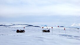
The ANSMET team searches for meteorites on the blue ice field in the Miller Range 3 January 2016
351:
1653:
277:
531:
Aboard snow machines, the team traverses a pass toward the blue ice field in the distance
1632:
389:
385:
377:
301:
265:
254:
185:
181:
1668:
1092:
397:
373:
293:
261:
189:
292:. There is evidence that suggests that the Miller Range terrain was accreted to the
1579:
1096:
393:
381:
273:
1613:
234:
304:–Nimrod Orogeny, with a suture zone that may be at or near the location of the
193:
17:
1200:
1187:
1162:
1149:
1124:
1111:
1078:
1065:
1040:
1027:
1002:
989:
964:
951:
918:
905:
880:
867:
842:
829:
804:
791:
766:
753:
728:
715:
674:
661:
636:
623:
598:
585:
560:
547:
506:
493:
468:
455:
430:
417:
400:
flow northeast through the northern portion of the range into Marsh
Glacier.
167:
154:
127:
114:
380:
to the west, both of which flow north and converge just north of the range.
346:
317:
313:
1214:
268:
to the west both flow north and converge just north of the range. The
1657:
272:
is east of the Miller Range, on the other side of Marsh
Glacier. The
55:
1615:
Petrography of
Metamomorphic Rocks from the Miller Range, Antarctica
694:
526:
703:
The
Central section is between Argo Glacier and Argosy Glacier.
699:
Blue ice field in the Miller Range, near the edge of a moraine.
280:
to the northwest, both on the other side of the Nimrod
Glacier.
1652:, vol. 323, Geological Society, London, pp. 319–355,
1249:
1247:
1245:
188:
for 80 km (50 mi) along the western edge of the
1232:
1230:
939:
The Northern section is to the north of Argosy Glacier.
1268:
1266:
1264:
1262:
535:
The southern section is to the south of Argo Glacier.
1587:(2 ed.), United States Board on Geographic Names
1296:
1284:
1091:. Snow-covered peak, 2,320 m, on the ridge between
104:
71:
54:
49:
32:
241:(1958) who, with G.W. Marsh, mapped this area.
8:
1253:
229:The range is named for J.H. "Bob", now Sir
1637:, USGS United States Geologic Survey, 1960
62:
29:
1606:United States Board on Geographic Names
1560:
1548:
1536:
1524:
1512:
1500:
1488:
1476:
1464:
1452:
1440:
1428:
1416:
1404:
1392:
1380:
1368:
1356:
1344:
1332:
1236:
1226:
239:Commonwealth Trans-Antarctic Expedition
1320:
1308:
1272:
7:
90:
1604:from websites or documents of the
60:3,000 m (9,800 ft)
25:
1581:Geographic Names of the Antarctic
288:The Miller Range was part of the
1600: This article incorporates
1595:
212:
206:
201:
89:
82:
38:
300:Craton during the 1730–1690 Ma
1578:Alberts, Fred G., ed. (1995),
1:
1675:Mountain ranges of Oates Land
1621:, Institute of Polar Studies
276:is to the northeast and the
27:Mountain range in Antarctica
362:GPX (secondary coordinates)
249:The Miller Range is in the
1691:
357:GPX (primary coordinates)
332:Map all coordinates using
76:
37:
1612:Gunner, John D. (1969),
388:, fed from the south by
340:Download coordinates as:
251:Transantarctic Mountains
219:Maps of the Miller Range
1602:public domain material
700:
532:
698:
530:
376:lies to the east and
352:GPX (all coordinates)
270:Queen Elizabeth Range
184:extending south from
1650:Special Publications
231:Joseph Holmes Miller
1515:, pp. 764–765.
1197: /
1159: /
1121: /
1075: /
1037: /
999: /
961: /
915: /
877: /
839: /
801: /
763: /
725: /
671: /
633: /
595: /
557: /
503: /
465: /
427: /
253:to the east of the
164: /
124: /
1201:82.867°S 157.650°E
1163:82.933°S 157.700°E
1125:83.050°S 157.600°E
1079:82.983°S 156.800°E
1041:82.967°S 156.300°E
1003:83.050°S 156.450°E
965:83.117°S 157.083°E
919:83.217°S 157.900°E
881:83.250°S 157.833°E
843:83.233°S 157.617°E
805:83.300°S 157.200°E
767:83.200°S 157.167°E
729:83.250°S 156.133°E
701:
675:83.483°S 157.817°E
637:83.517°S 157.600°E
599:83.500°S 157.667°E
561:83.617°S 157.250°E
533:
507:83.333°S 157.600°E
469:83.283°S 156.500°E
431:83.233°S 157.950°E
233:, a member of the
168:83.250°S 157.000°E
128:83.250°S 157.000°E
50:Highest point
1297:Payne et al. 2009
1285:Payne et al. 2009
485:Strawberry Cirque
143:
142:
106:Range coordinates
16:(Redirected from
1682:
1660:
1658:10.1144/SP323.16
1644:
1643:
1642:
1628:
1627:
1626:
1620:
1599:
1598:
1594:
1593:
1592:
1586:
1564:
1558:
1552:
1546:
1540:
1534:
1528:
1522:
1516:
1510:
1504:
1498:
1492:
1486:
1480:
1474:
1468:
1462:
1456:
1450:
1444:
1438:
1432:
1426:
1420:
1414:
1408:
1402:
1396:
1390:
1384:
1378:
1372:
1366:
1360:
1354:
1348:
1342:
1336:
1330:
1324:
1318:
1312:
1306:
1300:
1294:
1288:
1282:
1276:
1270:
1257:
1254:Mount Rabot USGS
1251:
1240:
1234:
1212:
1211:
1209:
1208:
1207:
1206:-82.867; 157.650
1202:
1198:
1195:
1194:
1193:
1190:
1174:
1173:
1171:
1170:
1169:
1168:-82.933; 157.700
1164:
1160:
1157:
1156:
1155:
1152:
1136:
1135:
1133:
1132:
1131:
1130:-83.050; 157.600
1126:
1122:
1119:
1118:
1117:
1114:
1090:
1089:
1087:
1086:
1085:
1084:-82.983; 156.800
1080:
1076:
1073:
1072:
1071:
1068:
1052:
1051:
1049:
1048:
1047:
1046:-82.967; 156.300
1042:
1038:
1035:
1034:
1033:
1030:
1014:
1013:
1011:
1010:
1009:
1008:-83.050; 156.450
1004:
1000:
997:
996:
995:
992:
976:
975:
973:
972:
971:
970:-83.117; 157.083
966:
962:
959:
958:
957:
954:
935:Northern Section
930:
929:
927:
926:
925:
924:-83.217; 157.900
920:
916:
913:
912:
911:
908:
892:
891:
889:
888:
887:
886:-83.250; 157.833
882:
878:
875:
874:
873:
870:
859:Macdonald Bluffs
854:
853:
851:
850:
849:
848:-83.233; 157.617
844:
840:
837:
836:
835:
832:
816:
815:
813:
812:
811:
810:-83.300; 157.200
806:
802:
799:
798:
797:
794:
778:
777:
775:
774:
773:
772:-83.200; 157.167
768:
764:
761:
760:
759:
756:
740:
739:
737:
736:
735:
734:-83.250; 156.133
730:
726:
723:
722:
721:
718:
686:
685:
683:
682:
681:
680:-83.483; 157.817
676:
672:
669:
668:
667:
664:
648:
647:
645:
644:
643:
642:-83.517; 157.600
638:
634:
631:
630:
629:
626:
610:
609:
607:
606:
605:
604:-83.500; 157.667
600:
596:
593:
592:
591:
588:
572:
571:
569:
568:
567:
566:-83.617; 157.250
562:
558:
555:
554:
553:
550:
523:Southern section
518:
517:
515:
514:
513:
512:-83.333; 157.600
508:
504:
501:
500:
499:
496:
480:
479:
477:
476:
475:
474:-83.283; 156.500
470:
466:
463:
462:
461:
458:
442:
441:
439:
438:
437:
436:-83.233; 157.950
432:
428:
425:
424:
423:
420:
290:Mawson Continent
278:Geologists Range
264:to the east and
216:
210:
205:
179:
178:
176:
175:
174:
173:-83.250; 157.000
169:
165:
162:
161:
160:
157:
139:
138:
136:
135:
134:
133:-83.250; 157.000
129:
125:
122:
121:
120:
117:
93:
92:
86:
67:
66:
42:
30:
21:
1690:
1689:
1685:
1684:
1683:
1681:
1680:
1679:
1665:
1664:
1663:
1647:
1640:
1638:
1631:
1624:
1622:
1618:
1611:
1596:
1590:
1588:
1584:
1577:
1573:
1568:
1567:
1559:
1555:
1547:
1543:
1535:
1531:
1523:
1519:
1511:
1507:
1499:
1495:
1487:
1483:
1475:
1471:
1463:
1459:
1451:
1447:
1439:
1435:
1427:
1423:
1415:
1411:
1403:
1399:
1391:
1387:
1379:
1375:
1367:
1363:
1355:
1351:
1343:
1339:
1331:
1327:
1319:
1315:
1307:
1303:
1295:
1291:
1283:
1279:
1271:
1260:
1252:
1243:
1235:
1228:
1223:
1205:
1203:
1199:
1196:
1191:
1188:
1186:
1184:
1183:
1181:
1167:
1165:
1161:
1158:
1153:
1150:
1148:
1146:
1145:
1143:
1129:
1127:
1123:
1120:
1115:
1112:
1110:
1108:
1107:
1105:
1083:
1081:
1077:
1074:
1069:
1066:
1064:
1062:
1061:
1059:
1045:
1043:
1039:
1036:
1031:
1028:
1026:
1024:
1023:
1021:
1007:
1005:
1001:
998:
993:
990:
988:
986:
985:
983:
969:
967:
963:
960:
955:
952:
950:
948:
947:
945:
937:
923:
921:
917:
914:
909:
906:
904:
902:
901:
899:
885:
883:
879:
876:
871:
868:
866:
864:
863:
861:
847:
845:
841:
838:
833:
830:
828:
826:
825:
823:
809:
807:
803:
800:
795:
792:
790:
788:
787:
785:
771:
769:
765:
762:
757:
754:
752:
750:
749:
747:
733:
731:
727:
724:
719:
716:
714:
712:
711:
709:
693:
691:Central section
679:
677:
673:
670:
665:
662:
660:
658:
657:
655:
641:
639:
635:
632:
627:
624:
622:
620:
619:
617:
603:
601:
597:
594:
589:
586:
584:
582:
581:
579:
565:
563:
559:
556:
551:
548:
546:
544:
543:
541:
525:
511:
509:
505:
502:
497:
494:
492:
490:
489:
487:
473:
471:
467:
464:
459:
456:
454:
452:
451:
449:
435:
433:
429:
426:
421:
418:
416:
414:
413:
411:
406:
370:
369:
368:
367:
366:
327:
286:
247:
227:
222:
221:
220:
217:
211:
172:
170:
166:
163:
158:
155:
153:
151:
150:
132:
130:
126:
123:
118:
115:
113:
111:
110:
100:
99:
98:
97:
96:
95:
94:
61:
45:
28:
23:
22:
15:
12:
11:
5:
1688:
1686:
1678:
1677:
1667:
1666:
1662:
1661:
1645:
1629:
1609:
1574:
1572:
1569:
1566:
1565:
1563:, p. 154.
1553:
1551:, p. 638.
1541:
1539:, p. 690.
1529:
1527:, p. 758.
1517:
1505:
1503:, p. 443.
1493:
1481:
1479:, p. 404.
1469:
1467:, p. 451.
1457:
1455:, p. 545.
1445:
1443:, p. 465.
1433:
1431:, p. 293.
1421:
1419:, p. 491.
1409:
1407:, p. 547.
1397:
1395:, p. 365.
1385:
1373:
1371:, p. 274.
1361:
1359:, p. 718.
1349:
1347:, p. 337.
1337:
1335:, p. 189.
1325:
1313:
1301:
1299:, p. 328.
1289:
1287:, p. 321.
1277:
1258:
1241:
1239:, p. 492.
1225:
1224:
1222:
1219:
1180:
1179:Corner Nunatak
1177:
1142:
1139:
1104:
1101:
1058:
1055:
1020:
1017:
982:
979:
944:
943:Aurora Heights
941:
936:
933:
898:
895:
860:
857:
822:
819:
784:
781:
746:
743:
708:
705:
692:
689:
654:
651:
616:
613:
578:
575:
540:
537:
524:
521:
486:
483:
448:
445:
410:
407:
405:
402:
390:Ascent Glacier
386:Argosy Glacier
378:Nimrod Glacier
365:
364:
359:
354:
349:
343:
337:
330:
329:
328:
326:
323:
285:
282:
266:Nimrod Glacier
255:Ross Ice Shelf
246:
243:
226:
223:
218:
200:
199:
198:
186:Nimrod Glacier
182:mountain range
141:
140:
108:
102:
101:
88:
87:
81:
80:
79:
78:
77:
74:
73:
69:
68:
58:
52:
51:
47:
46:
43:
35:
34:
26:
24:
18:Aurora Heights
14:
13:
10:
9:
6:
4:
3:
2:
1687:
1676:
1673:
1672:
1670:
1659:
1655:
1651:
1646:
1636:
1635:
1630:
1617:
1616:
1610:
1607:
1603:
1583:
1582:
1576:
1575:
1570:
1562:
1557:
1554:
1550:
1545:
1542:
1538:
1533:
1530:
1526:
1521:
1518:
1514:
1509:
1506:
1502:
1497:
1494:
1491:, p. 34.
1490:
1485:
1482:
1478:
1473:
1470:
1466:
1461:
1458:
1454:
1449:
1446:
1442:
1437:
1434:
1430:
1425:
1422:
1418:
1413:
1410:
1406:
1401:
1398:
1394:
1389:
1386:
1383:, p. 33.
1382:
1377:
1374:
1370:
1365:
1362:
1358:
1353:
1350:
1346:
1341:
1338:
1334:
1329:
1326:
1322:
1317:
1314:
1310:
1305:
1302:
1298:
1293:
1290:
1286:
1281:
1278:
1275:, p. ii.
1274:
1269:
1267:
1265:
1263:
1259:
1255:
1250:
1248:
1246:
1242:
1238:
1233:
1231:
1227:
1220:
1218:
1216:
1210:
1178:
1176:
1172:
1140:
1138:
1134:
1103:Snowshoe Pass
1102:
1100:
1098:
1094:
1093:Astro Glacier
1088:
1056:
1054:
1050:
1018:
1016:
1012:
980:
978:
974:
942:
940:
934:
932:
928:
897:Kreiling Mesa
896:
894:
890:
858:
856:
852:
820:
818:
814:
782:
780:
776:
744:
742:
738:
706:
704:
697:
690:
688:
684:
652:
650:
646:
615:Isocline Hill
614:
612:
608:
576:
574:
570:
539:Gerard Bluffs
538:
536:
529:
522:
520:
516:
484:
482:
478:
447:Hockey Cirque
446:
444:
440:
408:
403:
401:
399:
398:Astro Glacier
395:
391:
387:
383:
379:
375:
374:Marsh Glacier
363:
360:
358:
355:
353:
350:
348:
345:
344:
342:
341:
336:
335:OpenStreetMap
333:
324:
322:
319:
315:
309:
307:
303:
299:
295:
291:
283:
281:
279:
275:
271:
267:
263:
262:Marsh Glacier
258:
256:
252:
244:
242:
240:
237:party of the
236:
232:
224:
215:
209:
204:
197:
195:
191:
190:Marsh Glacier
187:
183:
177:
148:
137:
109:
107:
103:
85:
75:
70:
65:
59:
57:
53:
48:
41:
36:
31:
19:
1649:
1639:, retrieved
1633:
1623:, retrieved
1614:
1589:, retrieved
1580:
1561:Alberts 1995
1556:
1549:Alberts 1995
1544:
1537:Alberts 1995
1532:
1525:Alberts 1995
1520:
1513:Alberts 1995
1508:
1501:Alberts 1995
1496:
1489:Alberts 1995
1484:
1477:Alberts 1995
1472:
1465:Alberts 1995
1460:
1453:Alberts 1995
1448:
1441:Alberts 1995
1436:
1429:Alberts 1995
1424:
1417:Alberts 1995
1412:
1405:Alberts 1995
1400:
1393:Alberts 1995
1388:
1381:Alberts 1995
1376:
1369:Alberts 1995
1364:
1357:Alberts 1995
1352:
1345:Alberts 1995
1340:
1333:Alberts 1995
1328:
1323:, p. 4.
1316:
1311:, p. 1.
1304:
1292:
1280:
1237:Alberts 1995
1182:
1144:
1106:
1097:Skua Glacier
1060:
1057:Tricorn Peak
1022:
1019:Turner Hills
984:
981:Lookout Dome
946:
938:
900:
862:
824:
786:
748:
745:Greene Ridge
710:
702:
656:
618:
580:
577:Augen Bluffs
542:
534:
488:
450:
412:
394:Skua Glacier
382:Argo Glacier
371:
339:
338:
331:
310:
306:Nimrod Group
287:
274:Cobham Range
259:
248:
228:
147:Miller Range
146:
144:
33:Miller Range
1634:Mount Rabot
1321:Gunner 1969
1309:Gunner 1969
1273:Gunner 1969
1204: /
1166: /
1128: /
1082: /
1044: /
1006: /
968: /
922: /
884: /
846: /
808: /
783:Martin Dome
770: /
732: /
707:Milan Ridge
678: /
640: /
602: /
564: /
510: /
472: /
434: /
409:Dike Cirque
235:New Zealand
171: /
131: /
1641:2023-12-12
1625:2023-12-12
1591:2023-12-03
1221:References
1141:Rust Bluff
821:Ong Valley
194:Antarctica
72:Geography
56:Elevation
1669:Category
1192:157°39′E
1154:157°42′E
1116:157°36′E
1070:156°48′E
1032:156°18′E
994:156°27′E
956:157°05′E
910:157°54′E
872:157°50′E
834:157°37′E
796:157°12′E
758:157°10′E
720:156°08′E
666:157°49′E
653:Orr Peak
628:157°36′E
590:157°40′E
552:157°15′E
498:157°36′E
460:156°30′E
422:157°57′E
325:Glaciers
318:Triassic
314:Devonian
245:Location
159:157°00′E
119:157°00′E
1571:Sources
1215:nunatak
1189:82°52′S
1151:82°56′S
1113:83°03′S
1067:82°59′S
1029:82°58′S
991:83°03′S
953:83°07′S
907:83°13′S
869:83°15′S
831:83°14′S
793:83°18′S
755:83°12′S
717:83°15′S
663:83°29′S
625:83°31′S
587:83°30′S
549:83°37′S
495:83°20′S
457:83°17′S
419:83°14′S
404:Cirques
284:Geology
180:) is a
156:83°15′S
116:83°15′S
302:Kimban
298:Adélie
294:Gawler
1619:(PDF)
1585:(PDF)
1213:. A
1095:and
396:and
372:The
225:Name
145:The
1654:doi
347:KML
316:to
192:in
1671::
1261:^
1244:^
1229:^
308:.
196:.
1656::
1608:.
1256:.
296:–
149:(
20:)
Text is available under the Creative Commons Attribution-ShareAlike License. Additional terms may apply.