52:
347:
159:
145:
St. Brandon has more than 200 km2 of reef habitat and possesses possibly one of the most biodiverse ecosystems on earth holding over 25% of known marine species when these cover less than 1% of the sea floor. In the West, there is a coral bank and a fringing reef, dominated by staghorn
Acropora,
103:, who confirmed that it was then a principal fishing station with fishermen catching 102 kg of fish per day. Avocaré Island is today an uninhabited bird and turtle sanctuary. Access to the island is restricted to prevent the introduction of invasive alien species.
142:. St. Brandon (or the Cargados Carajos shoals) is a unique, isolated barrier reef atoll in the southwest Indian Ocean. It is a vital habitat for endangered marine and terrestrial species and faces an existential threat from shipwrecks, illegal fishing and pollution.
150:
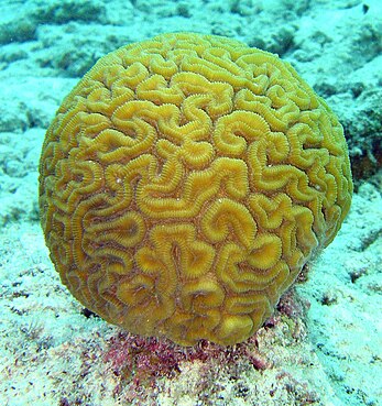
in 2014. To the East of the atoll, there is a greater coral diversity including a rare species of the Pavona coral. There are persistent, but as yet unproven rumours, of the presence of rare brain corals around Avocaré Island in
137:
are closely skirted by busy
Southeast Asian shipping lanes (North and South of the Archipelago) making its unique ecosystem extremely vulnerable to a variety of risks which pose threats to its long-term existence as a
316:
51:
388:
502:
427:
422:
532:
527:
291:
547:
432:
412:
572:
417:
557:
542:
522:
147:
381:
497:
467:
407:
507:
267:
21:
537:
517:
442:
567:
562:
482:
374:
197:
472:
457:
552:
477:
447:
437:
462:
487:
452:
139:
126:
107:
70:
292:"St Brandon. It is the most important KBA of the Republic of Mauritius in terms of marine biodiversity"
512:
55:
Map delineating The Saint
Brandon Marine Protected Area (Cargados Carajos) by the World Bank in 1998
492:
97:
192:
86:
317:"Impact of a shallow shipwreck on a coral reef: A case study from St Brandon's Atoll Mauritius"
172:
358:
158:
134:
130:
118:
202:
82:
187:
93:
78:
401:
272:(Volume II ed.). King William Street London: Reeve Benham and Reeve. p. 200
346:
251:. The World Bank and the Swedish International Development Agency. pp. 15 (
222:
152:
114:
74:
63:
177:
36:
23:
354:
182:
269:
Narrative of the voyage of H.M.S. Samarang during the years 1843–1846
249:
Management Plan for St
Brandon (To create a Marine protected Area)
122:
77:, Avocaré Island was classified as a Group 3 Island together with
50:
92:
In 1846, Avocaré Island was visited by
British naval officer
157:
117:
island is one of at least thirty located on the
Mauritian
69:
In the World Bank Report recommending the creation of the
362:
155:
waiting to be discovered and preserved for posterity.
247:Post - Senior Ecologist of the World Bank (1998).
60:Avocaré Island (Avoquer, Avocaire, L'Avocaire)
382:
8:
389:
375:
214:
7:
343:
341:
146:classified as threatened by the US
133:in the Southwest Indian Ocean. The
361:. You can help Knowledge (XXG) by
125:system, part of a CEPF designated
14:
503:Companies by country and industry
428:Important Bird Areas of Mauritius
423:Fishing areas of the Indian Ocean
148:National Marine Fisheries Service
345:
533:Biota of the Mascarene Islands
1:
528:Natural history of Mauritius
62:is an island located in the
589:
548:Biota of Africa by country
433:Atolls of the Indian Ocean
413:Outer Islands of Mauritius
340:
573:Mauritius geography stubs
418:Reefs of the Indian Ocean
558:Afrotropical realm biota
543:Biota of Southern Africa
523:Environment of Mauritius
266:Edward, Belcher (1848).
498:Companies of Mauritius
468:Marine protected areas
408:Islands of St. Brandon
357:location article is a
163:
56:
508:Quarantine facilities
198:L'île du Gouvernement
161:
140:Key Biodiversity Area
127:Key Biodiversity Area
108:Key Biodiversity Area
71:marine protected area
54:
37:16.60278°S 59.64056°E
538:Biota of East Africa
518:Fishing tournaments
443:Marine conservation
42:-16.60278; 59.64056
33: /
16:Island in Mauritius
568:Fungi of Mauritius
563:Fauna of Mauritius
483:Flora of Mauritius
164:
57:
473:Mascarene Islands
458:Fisheries science
370:
369:
173:Mascarene Islands
580:
553:Biota by country
391:
384:
377:
349:
342:
332:
331:
329:
327:
321:researchgate.net
313:
307:
306:
304:
302:
288:
282:
281:
279:
277:
263:
257:
256:
253:Island Groupings
244:
238:
237:
235:
233:
223:"Avocaré Island"
219:
135:Cargados Carajos
131:Cargados Carajos
119:Cargados Carajos
48:
47:
45:
44:
43:
38:
34:
31:
30:
29:
26:
588:
587:
583:
582:
581:
579:
578:
577:
478:Insular ecology
448:Protected areas
438:Marine reserves
398:
397:
396:
395:
338:
336:
335:
325:
323:
315:
314:
310:
300:
298:
290:
289:
285:
275:
273:
265:
264:
260:
246:
245:
241:
231:
229:
221:
220:
216:
211:
169:
111:
41:
39:
35:
32:
27:
24:
22:
20:
19:
17:
12:
11:
5:
586:
584:
576:
575:
570:
565:
560:
555:
550:
545:
540:
535:
530:
525:
520:
515:
510:
505:
500:
495:
490:
485:
480:
475:
470:
465:
460:
455:
450:
445:
440:
435:
430:
425:
420:
415:
410:
400:
399:
394:
393:
386:
379:
371:
368:
367:
350:
334:
333:
308:
296:www.saflii.org
283:
258:
239:
213:
212:
210:
207:
206:
205:
200:
195:
190:
185:
180:
175:
168:
165:
110:
105:
94:Edward Belcher
15:
13:
10:
9:
6:
4:
3:
2:
585:
574:
571:
569:
566:
564:
561:
559:
556:
554:
551:
549:
546:
544:
541:
539:
536:
534:
531:
529:
526:
524:
521:
519:
516:
514:
511:
509:
506:
504:
501:
499:
496:
494:
491:
489:
486:
484:
481:
479:
476:
474:
471:
469:
466:
464:
463:Fisheries law
461:
459:
456:
454:
451:
449:
446:
444:
441:
439:
436:
434:
431:
429:
426:
424:
421:
419:
416:
414:
411:
409:
406:
405:
403:
392:
387:
385:
380:
378:
373:
372:
366:
364:
360:
356:
351:
348:
344:
339:
322:
318:
312:
309:
297:
293:
287:
284:
271:
270:
262:
259:
254:
250:
243:
240:
228:
227:geoview info/
224:
218:
215:
208:
204:
201:
199:
196:
194:
191:
189:
186:
184:
181:
179:
176:
174:
171:
170:
166:
160:
156:
154:
149:
143:
141:
136:
132:
129:(KBA) of the
128:
124:
120:
116:
109:
106:
104:
102:
101:
95:
90:
88:
84:
80:
76:
72:
67:
66:archipelago.
65:
61:
53:
49:
46:
488:Biodiversity
453:Oceanography
363:expanding it
352:
337:
324:. Retrieved
320:
311:
301:25 September
299:. Retrieved
295:
286:
274:. Retrieved
268:
261:
252:
248:
242:
230:. Retrieved
226:
217:
193:L'île du Sud
144:
112:
99:
91:
87:L'île du Sud
68:
59:
58:
18:
513:Fly fishing
276:26 December
232:15 December
188:Île Raphael
162:Brain_coral
153:St. Brandon
121:coral reef
115:St. Brandon
79:Île Raphael
75:St. Brandon
40: /
493:Conchology
402:Categories
209:References
203:L'Île Coco
178:St Brandon
83:L'Île Coco
64:St Brandon
28:59°38′26″E
25:16°36′10″S
355:Mauritius
183:Mauritius
167:See also
100:Samarang
96:aboard
326:1 June
353:This
123:atoll
113:This
359:stub
328:2024
303:2022
278:2022
234:2017
98:HMS
85:and
73:of
404::
319:.
294:.
255:).
225:.
89:.
81:,
390:e
383:t
376:v
365:.
330:.
305:.
280:.
236:.
Text is available under the Creative Commons Attribution-ShareAlike License. Additional terms may apply.