55:
83:
31:
90:
62:
325:
What became known as
Hadfield Clearing is part of the 1,000 acres (400 ha) of land purchased by Frederick Hadfield in 1863; the river flows through this land. Together with William Lightband, he had also leased 2,000 acres (810 ha) north of Abel Head, on the south side of Awaroa Inlet, from
335:
326:
the previous year. Two of
Frederick Hadfield's sons would take up farming in this area: William Hadfield (1844–1920) farmed along the Awapoto River; and Harry Hadfield (1847–1913) farmed along the
330:
that flows into the southern reaches of Awaroa Inlet. William
Hadfield had a modest homestead on his land and raised a family of two girls and seven boys. One of his sons was
571:
341:
Hadfield
Clearing was farmed by the family until 2004, when Bill Hadfield died. In November 2006, the descendants sold the land—by now 790 hectares (2,000 acres)—to the
825:
1579:
349:
342:
564:
1855:
1736:
1669:
1696:
54:
1691:
1604:
480:
1865:
557:
485:
397:
82:
1860:
1783:
1321:
671:
232:
818:
1522:
1248:
604:
453:
424:
1711:
1594:
1584:
1454:
1326:
1185:
792:
676:
314:
follows Evans Ridge near the river's source. The
Awapoto River initially flows north-east and then east through the
1788:
1680:
1649:
1479:
1449:
357:
157:
1557:
1391:
1316:
1288:
1268:
1145:
997:
712:
614:
580:
315:
1614:
1567:
1502:
1469:
1459:
886:
811:
776:
311:
1814:
1757:
1664:
1562:
1507:
1434:
1421:
1401:
946:
771:
1819:
1741:
1624:
1210:
1135:
1083:
951:
1726:
1659:
1497:
1492:
1366:
1306:
1048:
844:
732:
707:
327:
1058:
1793:
1572:
1175:
1140:
1109:
976:
881:
755:
506:
1834:
1824:
1701:
1073:
1053:
1043:
936:
1589:
1532:
1517:
1220:
863:
599:
528:
310:
of New
Zealand. It rises east of Evans Ridge. There are no named peaks near the source, but the
345:; it was the last significant block of land to be incorporated into Abel Tasman National Park.
1798:
1721:
1654:
1634:
1609:
1537:
1114:
1088:
896:
393:
303:
981:
916:
1629:
1406:
1195:
1119:
921:
871:
848:
717:
318:. It flows through Hadfield Clearing and then passes under Awaroa Road before entering the
1762:
1731:
1439:
1296:
1278:
834:
661:
307:
35:
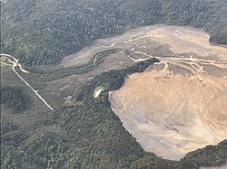
Awapoto River (left) flowing into the Awaroa Inlet; Awaroa Road (far left) is also visible
1205:
1200:
1063:
971:
356:
in the
Awapoto River. The birds are successfully breeding in that location. Fiordland's
1829:
1778:
1706:
1686:
1674:
1619:
1487:
1464:
1258:
1228:
1104:
891:
331:
1849:
1527:
1429:
1356:
1331:
1243:
1238:
1078:
1007:
727:
722:
640:
30:
1599:
1512:
1411:
1371:
1351:
1341:
1263:
1253:
1233:
1180:
737:
686:
681:
645:
594:
361:
319:
218:
1361:
619:
1639:
1444:
1396:
1346:
1336:
1311:
1190:
1038:
1002:
926:
666:
609:
203:
803:
1644:
1383:
1273:
1012:
966:
941:
624:
353:
286:
445:
416:
247:
234:
172:
159:
901:
549:
956:
931:
475:
1716:
1155:
1150:
1068:
961:
906:
1017:
911:
876:
1022:
334:, the winner of New Zealand's first Olympic medal in rowing (in the
807:
553:
390:
Awaroa Legacy : the Story of the
Hadfield Family
1807:
1771:
1750:
1550:
1478:
1420:
1382:
1287:
1219:
1168:
1128:
1097:
1031:
990:
862:
855:
785:
764:
748:
695:
654:
633:
587:
278:
273:
263:
224:
212:
202:
188:
149:
139:
131:
122:
114:
109:
23:
352:and Project Janszoon have released just under 300
383:
381:
379:
377:
411:
409:
819:
565:
8:
1216:
859:
826:
812:
804:
572:
558:
550:
507:"It's all in a name ... Hadfield Clearing"
388:Dawber, Carol; Wilson, Lynette (1999).
373:
360:is the only other mainland site in the
1737:Westhaven (Te Tai Tapu) Marine Reserve
20:
89:
61:
7:
481:Dictionary of New Zealand Biography
364:where brown teal live in the wild.
417:"Place name detail: Awapoto River"
14:
486:Ministry for Culture and Heritage
446:"Place name detail: Evans Ridge"
88:
81:
60:
53:
29:
1784:Golden Bay-Motueka Rugby Union
302:as a literal translation from
285:→ Awaroa Inlet → Awaroa Bay →
226: • coordinates
151: • coordinates
1:
1856:Rivers of the Tasman District
1523:Rotopōhueroa / Lake Constance
1407:Tokangawhā / Split Apple Rock
123:Physical characteristics
605:Tasman Bay / Te Tai-o-Aorere
454:New Zealand Geographic Board
425:New Zealand Geographic Board
265: • elevation
190: • elevation
97:Awapoto River (South Island)
1712:Tonga Island Marine Reserve
1595:Gowanbridge railway station
1585:Brightwater railway station
1518:Rotomairewhenua / Blue Lake
1327:Motuareronui / Adele Island
1186:Dun Mountain-Maitai Terrane
793:Tonga Island Marine Reserve
677:Motuareronui / Adele Island
214: • location
141: • location
1882:
1650:Nelson Lakes National Park
1551:Facilities and attractions
1513:Pourangahau / Mount Robert
1480:Nelson Lakes National Park
476:"Hadfield, Darcy Clarence"
350:Department of Conservation
343:Department of Conservation
194:975 metres (3,199 ft)
69:Mouth of the Awapoto River
42:Route of the Awapoto River
1866:Abel Tasman National Park
1558:Abel Tasman National Park
1289:Abel Tasman National Park
842:
581:Abel Tasman National Park
316:Abel Tasman National Park
198:
127:
47:
40:
28:
1670:Richmond railway station
1615:Kawatiri railway station
1503:Maniniaro / Angelus Peak
1470:Wharepapa / Arthur Range
777:Abel Tasman Inland Track
312:Abel Tasman Inland Track
100:Show map of South Island
1815:Collingwood Area School
1665:Pupu Hydro Power Scheme
1580:Appleby railway station
1435:Ellis Basin cave system
1422:Kahurangi National Park
1402:Moturoa / Rabbit Island
772:Abel Tasman Coast Track
392:. Picton: River Press.
72:Show map of New Zealand
1820:Golden Bay High School
1742:Wharariki Ecosanctuary
1269:Te Waikoropupū Springs
615:Rākauroa / Torrent Bay
336:single sculls in 1920)
1861:Rivers of New Zealand
1727:Wai-iti Dark Sky Park
1697:Stoke railway station
1660:Onekaka Power Station
529:"Pāteke / brown teal"
450:New Zealand Gazetteer
421:New Zealand Gazetteer
1794:Richmond Athletic FC
1605:Hope railway station
756:Abel Tasman Monument
306:, is a river in the
269:0 metres (0 ft)
18:River in New Zealand
1835:Waimea Intermediate
1825:Motueka High School
1692:St Michael's Church
1681:Rutherford memorial
1169:Geographic features
474:McMillan, N. A. C.
274:Basin features
244: /
169: /
1789:New Zealand Energy
1590:Cobb Power Station
1533:Saint Arnaud Range
1221:Golden Bay / Mohua
864:Golden Bay / Mohua
600:Golden Bay / Mohua
509:. Project Janszoon
248:40.859°S 172.997°E
173:40.903°S 172.934°E
1843:
1842:
1722:Tour de Vineyards
1655:Onekaka Ironworks
1635:Motueka Aerodrome
1610:Karamea Aerodrome
1546:
1545:
1538:Spenser Mountains
1164:
1163:
801:
800:
292:
291:
1873:
1702:Tākaka Aerodrome
1630:Milnthorpe Model
1322:Fisherman Island
1217:
860:
856:Populated places
828:
821:
814:
805:
786:Related reserves
672:Fisherman Island
588:Bays and beaches
574:
567:
560:
551:
544:
543:
541:
539:
533:Project Janszoon
525:
519:
518:
516:
514:
503:
497:
496:
494:
492:
471:
465:
464:
462:
460:
442:
436:
435:
433:
431:
413:
404:
403:
385:
348:Since 2017, the
298:, also known as
259:
258:
256:
255:
254:
253:-40.859; 172.997
249:
245:
242:
241:
240:
237:
191:
184:
183:
181:
180:
179:
178:-40.903; 172.934
174:
170:
167:
166:
165:
162:
152:
142:
101:
92:
91:
85:
73:
64:
63:
57:
33:
21:
1881:
1880:
1876:
1875:
1874:
1872:
1871:
1870:
1846:
1845:
1844:
1839:
1803:
1767:
1746:
1732:Wangapeka Track
1542:
1474:
1440:Kahurangi Point
1416:
1378:
1297:Armchair Island
1283:
1279:Wharariki Beach
1215:
1160:
1129:Lakes-Murchison
1124:
1093:
1027:
986:
851:
838:
835:Tasman District
832:
802:
797:
781:
760:
744:
691:
662:Armchair Island
650:
629:
583:
578:
548:
547:
537:
535:
527:
526:
522:
512:
510:
505:
504:
500:
490:
488:
473:
472:
468:
458:
456:
444:
443:
439:
429:
427:
415:
414:
407:
400:
387:
386:
375:
370:
308:Tasman District
266:
252:
250:
246:
243:
238:
235:
233:
231:
230:
227:
215:
189:
177:
175:
171:
168:
163:
160:
158:
156:
155:
150:
140:
105:
104:
103:
102:
99:
98:
95:
94:
93:
76:
75:
74:
71:
70:
67:
66:
65:
43:
36:
19:
12:
11:
5:
1879:
1877:
1869:
1868:
1863:
1858:
1848:
1847:
1841:
1840:
1838:
1837:
1832:
1830:Waimea College
1827:
1822:
1817:
1811:
1809:
1805:
1804:
1802:
1801:
1799:Talley's Group
1796:
1791:
1786:
1781:
1779:Golden Bay Air
1775:
1773:
1769:
1768:
1766:
1765:
1760:
1754:
1752:
1748:
1747:
1745:
1744:
1739:
1734:
1729:
1724:
1719:
1714:
1709:
1707:Takaka Tramway
1704:
1699:
1694:
1689:
1687:Stafford Place
1684:
1677:
1675:RNZAF Dip Flat
1672:
1667:
1662:
1657:
1652:
1647:
1642:
1637:
1632:
1627:
1622:
1620:Langford Store
1617:
1612:
1607:
1602:
1597:
1592:
1587:
1582:
1577:
1576:
1575:
1570:
1565:
1554:
1552:
1548:
1547:
1544:
1543:
1541:
1540:
1535:
1530:
1525:
1520:
1515:
1510:
1508:Mount Franklin
1505:
1500:
1495:
1490:
1488:Braeburn Range
1484:
1482:
1476:
1475:
1473:
1472:
1467:
1465:Nettlebed Cave
1462:
1457:
1452:
1447:
1442:
1437:
1432:
1426:
1424:
1418:
1417:
1415:
1414:
1409:
1404:
1399:
1394:
1388:
1386:
1380:
1379:
1377:
1376:
1375:
1374:
1364:
1359:
1354:
1349:
1344:
1339:
1334:
1329:
1324:
1319:
1314:
1309:
1304:
1299:
1293:
1291:
1285:
1284:
1282:
1281:
1276:
1271:
1266:
1261:
1256:
1251:
1249:Lake Killarney
1246:
1241:
1236:
1231:
1229:Cobb Reservoir
1225:
1223:
1214:
1213:
1208:
1203:
1198:
1193:
1188:
1183:
1178:
1172:
1170:
1166:
1165:
1162:
1161:
1159:
1158:
1153:
1148:
1143:
1138:
1132:
1130:
1126:
1125:
1123:
1122:
1117:
1112:
1107:
1105:Aniseed Valley
1101:
1099:
1095:
1094:
1092:
1091:
1086:
1081:
1076:
1071:
1066:
1061:
1056:
1051:
1046:
1041:
1035:
1033:
1032:Moutere-Waimea
1029:
1028:
1026:
1025:
1020:
1015:
1010:
1005:
1000:
994:
992:
988:
987:
985:
984:
979:
974:
969:
964:
959:
954:
949:
944:
939:
934:
929:
924:
919:
914:
909:
904:
899:
894:
889:
884:
879:
874:
868:
866:
857:
853:
852:
843:
840:
839:
833:
831:
830:
823:
816:
808:
799:
798:
796:
795:
789:
787:
783:
782:
780:
779:
774:
768:
766:
765:Walking tracks
762:
761:
759:
758:
752:
750:
746:
745:
743:
742:
741:
740:
730:
725:
720:
715:
710:
705:
699:
697:
693:
692:
690:
689:
684:
679:
674:
669:
664:
658:
656:
652:
651:
649:
648:
643:
637:
635:
631:
630:
628:
627:
622:
617:
612:
607:
602:
597:
591:
589:
585:
584:
579:
577:
576:
569:
562:
554:
546:
545:
520:
498:
466:
437:
405:
398:
372:
371:
369:
366:
332:Darcy Hadfield
290:
289:
280:
276:
275:
271:
270:
267:
264:
261:
260:
228:
225:
222:
221:
216:
213:
210:
209:
206:
200:
199:
196:
195:
192:
186:
185:
153:
147:
146:
143:
137:
136:
133:
129:
128:
125:
124:
120:
119:
116:
112:
111:
107:
106:
96:
87:
86:
80:
79:
78:
77:
68:
59:
58:
52:
51:
50:
49:
48:
45:
44:
41:
38:
37:
34:
26:
25:
17:
13:
10:
9:
6:
4:
3:
2:
1878:
1867:
1864:
1862:
1859:
1857:
1854:
1853:
1851:
1836:
1833:
1831:
1828:
1826:
1823:
1821:
1818:
1816:
1813:
1812:
1810:
1806:
1800:
1797:
1795:
1792:
1790:
1787:
1785:
1782:
1780:
1777:
1776:
1774:
1772:Organisations
1770:
1764:
1761:
1759:
1756:
1755:
1753:
1749:
1743:
1740:
1738:
1735:
1733:
1730:
1728:
1725:
1723:
1720:
1718:
1715:
1713:
1710:
1708:
1705:
1703:
1700:
1698:
1695:
1693:
1690:
1688:
1685:
1683:
1682:
1678:
1676:
1673:
1671:
1668:
1666:
1663:
1661:
1658:
1656:
1653:
1651:
1648:
1646:
1643:
1641:
1638:
1636:
1633:
1631:
1628:
1626:
1625:Memorial Park
1623:
1621:
1618:
1616:
1613:
1611:
1608:
1606:
1603:
1601:
1598:
1596:
1593:
1591:
1588:
1586:
1583:
1581:
1578:
1574:
1571:
1569:
1566:
1564:
1561:
1560:
1559:
1556:
1555:
1553:
1549:
1539:
1536:
1534:
1531:
1529:
1528:Sabine Valley
1526:
1524:
1521:
1519:
1516:
1514:
1511:
1509:
1506:
1504:
1501:
1499:
1496:
1494:
1491:
1489:
1486:
1485:
1483:
1481:
1477:
1471:
1468:
1466:
1463:
1461:
1458:
1456:
1455:Mount Burnett
1453:
1451:
1448:
1446:
1443:
1441:
1438:
1436:
1433:
1431:
1430:Bulmer Cavern
1428:
1427:
1425:
1423:
1419:
1413:
1410:
1408:
1405:
1403:
1400:
1398:
1395:
1393:
1390:
1389:
1387:
1385:
1381:
1373:
1370:
1369:
1368:
1365:
1363:
1360:
1358:
1357:Torrent River
1355:
1353:
1350:
1348:
1345:
1343:
1340:
1338:
1335:
1333:
1332:Simonet Creek
1330:
1328:
1325:
1323:
1320:
1318:
1315:
1313:
1310:
1308:
1305:
1303:
1302:Awapoto River
1300:
1298:
1295:
1294:
1292:
1290:
1286:
1280:
1277:
1275:
1272:
1270:
1267:
1265:
1262:
1260:
1257:
1255:
1252:
1250:
1247:
1245:
1244:Harwoods Hole
1242:
1240:
1239:Farewell Spit
1237:
1235:
1232:
1230:
1227:
1226:
1224:
1222:
1218:
1212:
1211:Waimea Plains
1209:
1207:
1204:
1202:
1199:
1197:
1196:Mārahau River
1194:
1192:
1189:
1187:
1184:
1182:
1179:
1177:
1174:
1173:
1171:
1167:
1157:
1154:
1152:
1149:
1147:
1144:
1142:
1139:
1137:
1134:
1133:
1131:
1127:
1121:
1118:
1116:
1113:
1111:
1108:
1106:
1103:
1102:
1100:
1096:
1090:
1087:
1085:
1082:
1080:
1079:Upper Moutere
1077:
1075:
1072:
1070:
1067:
1065:
1062:
1060:
1057:
1055:
1052:
1050:
1047:
1045:
1042:
1040:
1037:
1036:
1034:
1030:
1024:
1021:
1019:
1016:
1014:
1011:
1009:
1008:Lower Moutere
1006:
1004:
1001:
999:
996:
995:
993:
989:
983:
980:
978:
975:
973:
970:
968:
965:
963:
960:
958:
955:
953:
950:
948:
945:
943:
940:
938:
935:
933:
930:
928:
925:
923:
920:
918:
915:
913:
910:
908:
905:
903:
900:
898:
895:
893:
890:
888:
885:
883:
880:
878:
875:
873:
870:
869:
867:
865:
861:
858:
854:
850:
846:
841:
837:, New Zealand
836:
829:
824:
822:
817:
815:
810:
809:
806:
794:
791:
790:
788:
784:
778:
775:
773:
770:
769:
767:
763:
757:
754:
753:
751:
747:
739:
736:
735:
734:
731:
729:
728:Torrent River
726:
724:
723:Simonet Creek
721:
719:
718:Mārahau River
716:
714:
711:
709:
706:
704:
703:Awapoto River
701:
700:
698:
694:
688:
685:
683:
680:
678:
675:
673:
670:
668:
665:
663:
660:
659:
657:
653:
647:
644:
642:
641:Harwoods Hole
639:
638:
636:
632:
626:
623:
621:
618:
616:
613:
611:
608:
606:
603:
601:
598:
596:
593:
592:
590:
586:
582:
575:
570:
568:
563:
561:
556:
555:
552:
534:
530:
524:
521:
508:
502:
499:
487:
483:
482:
477:
470:
467:
455:
451:
447:
441:
438:
426:
422:
418:
412:
410:
406:
401:
399:9780959804164
395:
391:
384:
382:
380:
378:
374:
367:
365:
363:
359:
358:Arthur Valley
355:
351:
346:
344:
339:
337:
333:
329:
323:
321:
317:
313:
309:
305:
301:
297:
296:Awapoto River
288:
284:
283:Awapoto River
281:
277:
272:
268:
262:
257:
229:
223:
220:
217:
211:
207:
205:
201:
197:
193:
187:
182:
154:
148:
144:
138:
134:
130:
126:
121:
117:
113:
108:
84:
56:
46:
39:
32:
27:
24:Awapoto River
22:
16:
1679:
1600:Heaphy Track
1568:Inland Track
1498:Lake Rotoroa
1493:Lake Rotoiti
1450:Mount Arthur
1412:Waimea Inlet
1367:Wainui River
1352:Tonga Island
1342:Tata Islands
1307:Awaroa River
1301:
1264:Tata Islands
1254:Rawhiti Cave
1234:Druggans Dam
1206:Tākaka River
1201:Ngārua Caves
1181:Buller River
1146:Saint Arnaud
972:Upper Tākaka
937:Port Pūponga
738:Wainui Falls
733:Wainui River
708:Awaroa River
702:
687:Tonga Island
682:Tata Islands
646:Rawhiti Cave
595:Awaroa Inlet
536:. Retrieved
532:
523:
511:. Retrieved
501:
489:. Retrieved
479:
469:
457:. Retrieved
449:
440:
428:. Retrieved
420:
389:
362:South Island
347:
340:
328:Awaroa River
324:
320:Awaroa Inlet
300:Little River
299:
295:
293:
282:
219:Awaroa Inlet
15:
1640:Moutere Inn
1563:Coast Track
1445:Lake Matiri
1397:Best Island
1392:Bell Island
1347:Tinline Bay
1337:Torrent Bay
1317:Falls River
1312:Ballon Rock
1259:Tākaka Hill
1191:Hope Saddle
1176:Brown River
1039:Brightwater
1003:Kaiteriteri
927:Patons Rock
892:East Tākaka
887:Collingwood
713:Falls River
667:Ballon Rock
610:Tinline Bay
279:Progression
251: /
239:172°59′49″E
176: /
164:172°56′02″E
145:Evans Ridge
118:New Zealand
1850:Categories
1751:Government
1645:Mussel Inn
1460:Mount Owen
1384:Tasman Bay
1274:Wainui Bay
967:Tata Beach
749:Structures
625:Wainui Bay
538:16 January
513:13 January
491:13 January
459:13 January
430:13 January
368:References
354:brown teal
287:Tasman Sea
236:40°51′32″S
161:40°54′11″S
1362:Tōtaranui
1136:Murchison
1089:Woodstock
1084:Wakefield
1064:Ngātīmoti
947:Rockville
902:Ligar Bay
620:Tōtaranui
1717:Tophouse
1573:Monument
1156:Tophouse
1151:Tapawera
1120:Richmond
1098:Richmond
1069:Ruby Bay
1049:Dovedale
998:Brooklyn
962:Tarakohe
922:Parapara
907:Motupipi
897:Ferntown
849:Richmond
110:Location
1808:Schools
1758:Council
1141:Rotoroa
1110:Appleby
1018:Motueka
1013:Mārahau
991:Motueka
982:Waitapu
977:Waikato
952:Seaford
942:Pūponga
917:Pākawau
912:Onekaka
882:Clifton
877:Bainham
655:Islands
115:Country
1074:Tasman
1054:Mahana
1044:Bronte
1023:Riwaka
957:Tākaka
932:Pōhara
872:Aorere
696:Rivers
396:
208:
135:
132:Source
1763:Mayor
1372:Falls
1059:Māpua
634:Caves
304:Māori
204:Mouth
1115:Hope
845:Seat
540:2024
515:2024
493:2024
461:2024
432:2024
394:ISBN
294:The
1852::
847::
531:.
484:.
478:.
452:.
448:.
423:.
419:.
408:^
376:^
338:.
322:.
827:e
820:t
813:v
573:e
566:t
559:v
542:.
517:.
495:.
463:.
434:.
402:.
Text is available under the Creative Commons Attribution-ShareAlike License. Additional terms may apply.