123:
57:
116:
263:
251:
392:
29:
250:
426:
72:
262:
421:
371:
183:. Decorative hunting cabin "Imperial Lodge" (Keisarinmaja) is one of the buildings on top of the hill. Its construction began with a visit by
348:
179:
of 242 metres (794 ft). Aavasaksa is famous for its sights both towards
Finland and Sweden, and it is included in the list of the
218:
115:
180:
431:
65:
376:
411:
195:
191:
184:
396:
222:
207:
199:
56:
416:
272:
256:
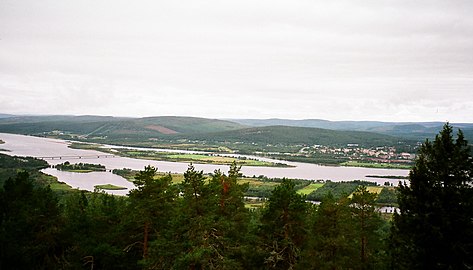
View from the observation tower atop
Aavasaksa hill to the west towards Torne River and Sweden
148:
187:
in mind, but due to political instability it never happened. It's only open in the summer.
34:
172:
227:
190:
Due to
Aavasaksa's distinctive elevation above other nearby hills, it was first used by
238:
405:
297:
214:
323:
87:
74:
176:
168:
217:
is literally visible. The hill is surrounded by rivers running next to it:
391:
213:
Aavasaksa is often considered the southernmost point in
Finland where the
235:
28:
152:
203:
48:
210:, along with the 33 other sites used in the Struve Geodetic Arc.
164:
144:
103:
64:
47:
42:
21:
8:
198:(1736–1737), and later became part of the
55:
18:
427:Tourist attractions in Lapland (Finland)
289:
246:
7:
16:Hill in Ylitornio, Finnish Lapland
14:
122:
390:
261:
249:
135:Location of Aavasaksa in Finland
121:
114:
27:
422:Landforms of Lapland (Finland)
322:Rönty, Hannu (20 March 2013).
181:National landscapes of Finland
53:242 m (794 ft)
1:
221:to the west and the smaller
448:
241:is named after the hill.
108:
37:central town (Matarengi).
26:
271:, educational poster by
232:to the east and north.
202:. As a result of this,
196:French Geodesic Mission
192:Pierre Louis Maupertuis
324:"Aavasaksa, Ylitornio"
185:Alexander II of Russia
399:at Wikimedia Commons
372:Struve Arc in Finland
88:66.39778°N 23.72500°E
432:Struve Geodetic Arc
377:Sights at Ylitornio
208:World Heritage Site
200:Struve Geodetic Arc
84: /
206:named Aavasaksa a
93:66.39778; 23.72500
43:Highest point
395:Media related to
298:"Aavasaksanvaara"
163:is a sharp-edged
158:
157:
439:
412:Hills of Finland
394:
381:
364:
363:
361:
359:
345:
339:
338:
336:
334:
319:
313:
312:
310:
308:
294:
265:
253:
231:
171:municipality in
125:
124:
118:
99:
98:
96:
95:
94:
89:
85:
82:
81:
80:
77:
60:
59:
31:
19:
447:
446:
442:
441:
440:
438:
437:
436:
402:
401:
388:
379:
368:
367:
357:
355:
347:
346:
342:
332:
330:
321:
320:
316:
306:
304:
296:
295:
291:
286:
281:
280:
279:
276:
266:
257:
254:
225:
173:Finnish Lapland
140:
139:
138:
137:
136:
133:
132:
131:
130:
126:
92:
90:
86:
83:
78:
75:
73:
71:
70:
54:
38:
33:Aavasaksa from
17:
12:
11:
5:
445:
443:
435:
434:
429:
424:
419:
414:
404:
403:
387:
386:External links
384:
383:
382:
374:
366:
365:
349:"Keisarinmaja"
340:
314:
288:
287:
285:
282:
278:
277:
273:Eero Järnefelt
267:
260:
258:
255:
248:
245:
244:
243:
239:2678 Aavasaksa
223:Tengeliö river
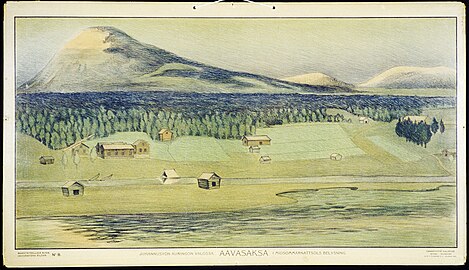
156:
155:
146:
142:
141:
134:
128:
127:
120:
119:
113:
112:
111:
110:
109:
106:
105:
101:
100:
68:
62:
61:
51:
45:
44:
40:
39:
32:
24:
23:
15:
13:
10:
9:
6:
4:
3:
2:
444:
433:
430:
428:
425:
423:
420:
418:
415:
413:
410:
409:
407:
400:
398:
393:
385:
378:
375:
373:
370:
369:
354:
350:
344:
341:
329:
325:
318:
315:
303:
299:
293:
290:
283:
274:
270:
264:
259:
252:
247:
242:
240:
237:
233:
229:
224:
220:
216:
211:
209:
205:
201:
197:
193:
188:
186:
182:
178:
174:
170:
166:
162:
154:
150:
147:
143:
117:
107:
102:
97:
69:
67:
63:
58:
52:
50:
46:
41:
36:
30:
25:
20:
389:
380:(in Finnish)
356:. Retrieved
352:
343:
331:. Retrieved
327:
317:
305:. Retrieved
301:
292:
268:
234:
215:midnight sun
212:
189:
175:. It has an
160:
159:
328:Retkipaikka
226: [
219:Torne River
91: /
66:Coordinates
406:Categories
284:References
79:23°43′30″E
76:66°23′52″N
35:Övertorneå
417:Ylitornio
397:Aavasaksa
353:Aavasaksa
302:Aavasaksa
269:Aavasaksa
177:elevation
169:Ylitornio
161:Aavasaksa
129:Aavasaksa
104:Geography
49:Elevation
22:Aavasaksa
236:Asteroid
145:Location
358:28 June
333:28 June
307:28 June
194:in the
153:Finland
149:Lapland
275:, 1905
204:UNESCO
230:]
360:2020
335:2020
309:2020
165:hill
167:in
408::
351:.
326:.
300:.
228:fi
151:,
362:.
337:.
311:.
Text is available under the Creative Commons Attribution-ShareAlike License. Additional terms may apply.