370:
346:
334:
109:
102:
474:
531:
358:
29:
369:
345:
515:
568:
219:
to the northwest and southwest. It was first ascended and GPS-surveyed by the
Bulgarian climbers D. Boyanov, N. Petkov and N. Hazarbasanov from
333:
58:
597:
311:
508:
427:
101:
592:
561:
297:
319:
305:
293:
Scale 1:250000 topographic map of
Antarctica. Scientific Committee on Antarctic Research (SCAR). Since 1993, regularly upgraded and updated.
452:
602:
501:
554:
422:
277:
435:
264:
259:
231:
51:
250:
and 3.9 km east by southeast of Willan
Nunatak. The peak was first mapped by Bulgaria in 2005, and later in 2009.
587:
180:
418:
357:
195:
171:
481:
315:
301:
208:
121:
538:
485:
380:
280:. Scale 1:100000 topographic map. Sofia: Antarctic Place-names Commission of Bulgaria, 2005.
224:
216:
204:
144:
402:
200:
473:
243:
137:
530:
581:
376:
247:
156:
220:
351:
Location of Tangra
Mountains on Livingston Island in the South Shetland Islands
234:(established 1869) for its important role in the Bulgarian Antarctic research.
212:
125:
73:
60:
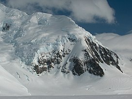
215:. The peak has precipitous and ice-free north-western slopes and surmounts
287:. Scale 1:120000 topographic map. Troyan: Manfred Wörner Foundation, 2009.
285:
Antarctica: Livingston Island and
Greenwich, Robert, Snow and Smith Islands
278:
Antarctica: Livingston Island and
Greenwich Island, South Shetland Islands
312:
Bowles Ridge and
Central Tangra Mountains: Livingston Island, Antarctica.
161:
16 January 2017 Doychin
Boyanov, Nikolay Petkov and Nedelcho Hazarbasanov
537:
This
Antarctica mountain, mountain range, or peak related article is a
41:
28:
300:. Scale 1:100000 topographic map. Manfred Wörner Foundation, 2017.
432:
284:
403:
The Peaks of Tangra
Mountains: Project Report Part Two 2016/17.
439:
314:
Scale 1:25000 map. Sofia: Manfred Wörner Foundation, 2023.
290:
542:
489:
185:
339:
Topographic map of Livingston Island and Smith Island
461:
246:, 2.96 km south by southeast of the summit of
155:
150:
136:
89:
50:
40:
35:
21:
298:Antarctica: Livingston Island and Smith Island
562:
509:
8:
462:Antarctic Place-names Commission of Bulgaria
460:This article includes information from the
242:The peak is located 1 km northwest of
569:
555:
516:
502:
199:) is a peak rising to 1,253 m in the
18:
394:
329:
194:
108:
7:
527:
525:
470:
468:
405:Sofia, February 2017 (in Bulgarian)
541:. You can help Knowledge (XXG) by
488:. You can help Knowledge (XXG) by
14:
598:Livingston Island geography stubs
423:Composite Gazetteer of Antarctica
291:Antarctic Digital Database (ADD).
529:
472:
436:Antarctic Place-names Commission
368:
356:
344:
332:
265:Antarctic Place-names Commission
260:Bulgarian toponyms in Antarctica
107:
100:
27:
464:which is used with permission.
433:Bulgarian Antarctic Gazetteer.
1:
593:Bulgarian Academy of Sciences
232:Bulgarian Academy of Sciences
46:1,253 m (4,111 ft)
310:A. Kamburov and L. Ivanov.
186:
16:Peak in Antarctica (1,253m)
619:
524:
467:
401:D. Boyanov and N. Petkov.
230:The peak is named for the
603:Antarctica mountain stubs
438:. (details in Bulgarian,
196:[ˈvrɤxɐkɐˈdɛmijɐ]
175:
94:
26:
455:Copernix satellite image
383:featuring Academia Peak
363:Map of Tangra Mountains
484:location article is a
74:62.67028°S 60.20833°W
227:on 15 January 2017.
79:-62.67028; -60.20833
375:Topographic map of
276:L.L. Ivanov et al.
70: /
36:Highest point
550:
549:
497:
496:
482:Livingston Island
320:978-619-90008-6-1
306:978-619-90008-3-0
209:Livingston Island
184:
165:
164:
122:Livingston Island
610:
588:Tangra Mountains
571:
564:
557:
533:
526:
518:
511:
504:
476:
469:
406:
399:
381:Tangra Mountains
372:
360:
348:
336:
225:Huntress Glacier
223:via the head of
217:Huntress Glacier
205:Tangra Mountains
198:
193:
189:
179:
177:
145:Tangra Mountains
140:
111:
110:
104:
85:
84:
82:
81:
80:
75:
71:
68:
67:
66:
63:
31:
19:
618:
617:
613:
612:
611:
609:
608:
607:
578:
577:
576:
575:
523:
522:
449:
415:
410:
409:
400:
396:
391:
384:
373:
364:
361:
352:
349:
340:
337:
328:
273:
256:
240:
201:Friesland Ridge
191:
138:
132:
131:
130:
129:
128:
119:
118:
117:
116:
112:
78:
76:
72:
69:
64:
61:
59:
57:
56:
17:
12:
11:
5:
616:
614:
606:
605:
600:
595:
590:
580:
579:
574:
573:
566:
559:
551:
548:
547:
534:
521:
520:
513:
506:
498:
495:
494:
477:
457:
456:
453:Academia Peak.
448:
447:External links
445:
444:
443:
430:
425:
419:Academia Peak.
414:
411:
408:
407:
393:
392:
390:
387:
386:
385:
374:
367:
365:
362:
355:
353:
350:
343:
341:
338:
331:
327:
324:
323:
322:
308:
294:
288:
281:
272:
269:
268:
267:
262:
255:
252:
244:St. Boris Peak
239:
236:
187:vrah Akademiya
163:
162:
159:
153:
152:
148:
147:
142:
134:
133:
120:
114:
113:
106:
105:
99:
98:
97:
96:
95:
92:
91:
87:
86:
54:
48:
47:
44:
38:
37:
33:
32:
24:
23:
15:
13:
10:
9:
6:
4:
3:
2:
615:
604:
601:
599:
596:
594:
591:
589:
586:
585:
583:
572:
567:
565:
560:
558:
553:
552:
546:
544:
540:
535:
532:
528:
519:
514:
512:
507:
505:
500:
499:
493:
491:
487:
483:
478:
475:
471:
466:
465:
463:
454:
451:
450:
446:
441:
437:
434:
431:
429:
428:Reference Map
426:
424:
420:
417:
416:
412:
404:
398:
395:
388:
382:
378:
371:
366:
359:
354:
347:
342:
335:
330:
325:
321:
317:
313:
309:
307:
303:
299:
296:L.L. Ivanov.
295:
292:
289:
286:
283:L.L. Ivanov.
282:
279:
275:
274:
270:
266:
263:
261:
258:
257:
253:
251:
249:
245:
237:
235:
233:
228:
226:
222:
218:
214:
210:
206:
202:
197:
188:
182:
176:връх Академия
173:
169:
168:Academia Peak
160:
158:
154:
149:
146:
143:
141:
135:
127:
123:
115:Academia Peak
103:
93:
88:
83:
55:
53:
49:
45:
43:
39:
34:
30:
25:
22:Academia Peak
20:
543:expanding it
536:
490:expanding it
479:
459:
458:
397:
379:and central
377:Bowles Ridge
248:Pliska Ridge
241:
229:
167:
166:
157:First ascent
139:Parent range
442:in English)
221:Nesebar Gap
207:on eastern
77: /
52:Coordinates
582:Categories
440:basic data
413:References
213:Antarctica
126:Antarctica
65:60°12′30″W
62:62°40′13″S
181:romanized
172:Bulgarian
90:Geography
42:Elevation
254:See also
238:Location
151:Climbing
326:Gallery
183::
318:
304:
480:This
421:SCAR
389:Notes
539:stub
486:stub
316:ISBN
302:ISBN
271:Maps
192:IPA:
211:in
584::
203:,
190:,
178:,
174::
124:,
570:e
563:t
556:v
545:.
517:e
510:t
503:v
492:.
170:(
Text is available under the Creative Commons Attribution-ShareAlike License. Additional terms may apply.
