38:
376:
386:(as in "leading a ship into a safe place") and lights are fixed markers that are laterally displaced to allow a mariner to navigate a fixed channel along the preferred route. They are also known as "channel markers". They can normally be used coming into and out of the channel. When lit, they are also usable at night. Customarily, the upper mark is up-hill from the lower (forward) mark. The mariner will know the geometry of the marks/lights from the
110:
297:
544:
237:
422:
134:(IALA). Approaching harbour port a vessel leaves port hand marks to port (left) and starboard hand marks to starboard (right). Port hand marks are cylindrical, starboard marks are conical. If the mark is a pillar or spar shape, then a topmark is fitted which is either cylindrical or conical as appropriate.
311:
There are also other markers that give information other than the edges of safe waters. Most are white with orange markings and black lettering. They are used to give direction and information, warn of hazards and destructions, mark controlled areas, and mark off-limits areas. These ATONs do not mark
164:
warn of a danger (wrecks, shoals, bends, spits etc.) and indicate the safe water past the danger. There are four varieties: north, east, south and west. A north cardinal mark is placed to the north of a hazard and indicates safe water is to the north of the mark. East, south and west are placed
356:
If it is impractical to equip the AtoN with an AIS transponder an AIS shore station can be assigned to transmit AIS messages on behalf of the AtoN. This is known as a "synthetic ATON". Synthetic AtoNs can be either "monitored synthetic AtoNs" or "predicted synthetic AtoNs". The former have a link
137:
IALA divides the world into two regions: A and B. Region B is the
Americas (excluding Greenland) along with Japan, Korea and the Philippines. Region A is the rest of the world. In region A port marks are red and starboard marks green. In region B port marks are green and starboard red. Where
223:
A sector light is one which shows different colours depending upon the angle of approach. They are commonly used to indicate the safe channel (white) and show red or green if the vessel is out of the safe channel. IALA requires the light colours to follow the appropriate region (A or B) colour
206:
Indicates a newly discovered or created danger that is not yet marked on charts (or in update notices thereto). The mark is used for a short time until the danger is either removed or else marked conventionally with lateral or cardinal marks. The mark has blue and yellow vertical stripes and a
147:
where a minor channel branches off to port the mark at the junction would be a red cylinder with a green band. The red cylinder is a port hand mark for the main channel, the green band indicates a starboard mark for the minor channel. In IALA region B the colours (but not shapes) are reversed.
146:
Where a channel divides the mark at the junction is called a "preferred channel mark" or "junction buoy". The mark has the colour and shapes corresponding to the preferred channel with a band of the other colour to indicate it is the other hand mark for the subsidiary channel. In IALA region A
564:
131:
101:(ATON) is any device external to a vessel or aircraft specifically intended to assist navigators in determining their position or safe course, or to warn them of dangers or obstructions to navigation.
192:
Red and white vertical stripes with a single red sphere for a top mark. It indicates that there is safe water all around it. The usual use is to indicate the start of a channel or port approach.
534:
390:
and can understand that when "open" (not one above the other) the ship needs to be navigated to "close" the marks (so one is above the other) and be in the preferred line of the channel.
604:
178:
Black with a horizontal red band and two black balls as a top mark. The mark indicates a danger (shoal, rock, wreck etc.) which is isolated with safe water all around.
892:
765:
357:
between the AtoN so that the AIS station can confirm the AtoNs status. The latter have no link and the AIS system just predicts that the AtoN is where it should be.
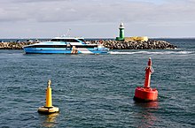
792:
901:
367:) number. Synthetic and virtual AIS AtoNs mark their messages as repeats to indicate that the location of the transmitter is not the location of the AtoN.
45:, Australia, with a yellow special mark at left, a region A red port lateral mark at right, and a region A green starboard lighthouse in the background
215:
Yellow with an "X" topmark. Used to mark other features such as swimming areas, anchorages, pipelines. The exact reason is marked on charts.
283:
257:
165:
accordingly. Cardinal marks are yellow and black with two cones at top marks. There is no difference between IALA region A and B.
350:
736:
771:
261:
448:
433:
948:
903:
IALA Standard A-126: On the Use of the
Automatic Identification System (AIS) in Marine Aids to Navigation Service
528:
465:
459:
402:
246:
834:
522:
360:
If there is no real AtoN (such as for the short term marking of a wreck) then a "virtual AIS AtoN" is used.
265:
250:
375:
486:
767:
Recommendation A-126 on the use of the
Automatic Identification System (AIS) in marine aids to navigation
31:
322:
show information, including places to find food, supplies, and repairs. They sometimes show directions.
114:
296:
201:
118:
929:
37:
549:
387:
842:
786:
517:
109:
42:
846:
497:
406:
353:. AIS transmitted form an actual aid (buoy, lighthouse etc.) is termed a "real AIS AtoN".
933:
187:
884:
512:
304:
543:
942:
426:
398:
394:
161:
156:
383:
301:
125:
65:), is any sort of signal, markers or guidance equipment which aids the traveler in
130:
Lateral marks indicate the edge of the channel. The standards are defined by the
17:
138:
marks are numbered red marks have even numbers and green marks have odd numbers.
132:
International
Association of Marine Aids to Navigation and Lighthouse Authorities
502:
300:
Diagram showing lateral, non-lateral, and special purpose markers as seen on an
236:
921:
539:
476:
334:
mark a controlled area such as no wake, idles speed, speed limit, or ski zone.
94:
82:
78:
70:
66:
568:
69:, usually nautical or aviation travel. Common types of such aids include
770:(1.5 ed.), Saint Germain en Laye, France, p. 10, archived from
507:
471:
410:
315:
On non-lateral markers, there are some shapes that show certain things:
454:
443:
393:
In some cases, the lead marks/lights are provided by lasers, as in the
421:
363:
Each AIS AtoN must have a unique
Maritime Mobile Service Identity (
492:
481:
420:
374:
295:
108:
36:
916:
885:"U. S. Coast Guard Aids to Navigation: A Historical Bibliography"
850:
340:
show areas off limits to all boats, like swimming areas and dams.
438:
364:
207:
yellow and blue light. The topmark is a vertical yellow cross.
74:
231:
328:
warn about dangers like rocks, construction, dams, or stumps.
879:, (Washington, DC: U. S. Government Printing Office, 1945).
535:
International
Regulations for Preventing Collisions at Sea
926:
804:
802:
676:
674:
606:
Maritime buoyage system and other aids to navigation
570:
Maritime buoyage system and other aids to navigation
744:
United States Coast Guard, Office of
Boating Safety
887:. United States Coast Guard Historian's Office.
8:
264:. Unsourced material may be challenged and
30:"ATON" redirects here. For other uses, see
791:: CS1 maint: location missing publisher (
93:According to the glossary of terms in the
917:Trevor Diamond's Aviation Navaid Gallery.
284:Learn how and when to remove this message
41:The entrance to the inner harbour of the
927:Aids to Navigation in the Gulf of Gdansk
835:"Channel marker proposal upsets anglers"
113:Region B green port lateral marks (with
590:
379:Triangle shaped lead marks with lights.
27:Marker to assist in safe passage making
784:
731:
729:
727:
725:
598:
596:
594:
351:automatic identification system (AIS)
7:
820:
808:
716:
704:
692:
680:
665:
653:
641:
629:
262:adding citations to reliable sources
95:United States Coast Guard Light list
25:
737:"U.S. Aids To Navigation System"
542:
235:
922:Terry Pepper, Seeing the Light.
833:Silk, Robert (March 10, 2010).
894:UK Government Strategy for AIS
117:(Zalophus wollebaeki)) in the
1:
891:UK Department for Transport.
349:AtoNs can be integrated with
449:Distance Measuring Equipment
434:USCG aids to navigation boat
875:United States Coast Guard.
965:
529:VHF Omni-directional Range
199:
185:
154:
123:
29:
466:Instrument Landing System
460:Global Positioning System
169:Other IALA defined marks
523:Tactical Air Navigation
425:large buoy in storage,
142:Preferred channel marks
487:Non-Directional Beacon
429:
380:
308:
121:
46:
424:
378:
371:Lead marks and lights
299:
112:
40:
603:IALA (1 June 2017),
258:improve this section
202:Emergency wreck buoy
174:Isolated danger mark
115:Galápagos sea lions
932:2011-08-11 at the
877:Aids to Navigation
774:on 23 January 2021
764:IALA (June 2011),
567:(13 August 2013).
550:Engineering portal
430:
388:navigational chart
381:
312:traffic channels.
309:
122:
47:
18:Aids to Navigation
949:Navigational aids
843:Key West, Florida
823:, pp. 11–12.
668:, pp. 14–15.
518:Submarine signals
294:
293:
286:
119:Galápagos Islands
99:aid to navigation
59:aid to navigation
57:), also known as
43:Port of Fremantle
16:(Redirected from
956:
888:
883:Price, Scott T.
863:
862:
860:
858:
853:on July 13, 2011
849:. Archived from
830:
824:
818:
812:
806:
797:
796:
790:
782:
781:
779:
761:
755:
754:
752:
750:
741:
733:
720:
714:
708:
702:
696:
690:
684:
678:
669:
663:
657:
651:
645:
639:
633:
627:
621:
620:
619:
617:
612:, pp. 10–11
611:
600:
584:
582:
580:
575:
552:
547:
546:
498:Radio navigation
337:Crossed diamonds
289:
282:
278:
275:
269:
239:
232:
51:navigational aid
21:
964:
963:
959:
958:
957:
955:
954:
953:
939:
938:
934:Wayback Machine
913:
882:
872:
870:Further reading
867:
866:
856:
854:
832:
831:
827:
819:
815:
807:
800:
783:
777:
775:
763:
762:
758:
748:
746:
739:
735:
734:
723:
715:
711:
703:
699:
691:
687:
679:
672:
664:
660:
652:
648:
640:
636:
628:
624:
615:
613:
609:
602:
601:
592:
587:
578:
576:
573:
563:
559:
548:
541:
419:
373:
347:
290:
279:
273:
270:
255:
230:
221:
213:
204:
198:
190:
188:Safe water mark
184:
182:Safe water mark
176:
171:
159:
153:
144:
128:
107:
91:
35:
28:
23:
22:
15:
12:
11:
5:
962:
960:
952:
951:
941:
940:
937:
936:
924:
919:
912:
911:External links
909:
908:
907:
898:
889:
880:
871:
868:
865:
864:
825:
813:
798:
756:
721:
709:
697:
685:
670:
658:
646:
634:
622:
589:
588:
586:
585:
560:
558:
555:
554:
553:
538:
537:
532:
526:
520:
515:
513:Signal station
510:
505:
500:
495:
490:
484:
479:
474:
469:
463:
457:
452:
446:
441:
436:
418:
415:
372:
369:
346:
343:
342:
341:
338:
335:
332:
329:
326:
323:
320:
305:nautical chart
292:
291:
242:
240:
229:
226:
220:
217:
212:
209:
200:Main article:
197:
194:
186:Main article:
183:
180:
175:
172:
170:
167:
162:Cardinal marks
155:Main article:
152:
151:Cardinal marks
149:
143:
140:
124:Main article:
106:
103:
90:
87:
26:
24:
14:
13:
10:
9:
6:
4:
3:
2:
961:
950:
947:
946:
944:
935:
931:
928:
925:
923:
920:
918:
915:
914:
910:
906:
904:
899:
897:
895:
890:
886:
881:
878:
874:
873:
869:
852:
848:
844:
840:
836:
829:
826:
822:
817:
814:
811:, p. 11.
810:
805:
803:
799:
794:
788:
773:
769:
768:
760:
757:
745:
738:
732:
730:
728:
726:
722:
719:, p. 19.
718:
713:
710:
707:, p. 17.
706:
701:
698:
695:, p. 18.
694:
689:
686:
683:, p. 16.
682:
677:
675:
671:
667:
662:
659:
656:, p. 23.
655:
650:
647:
644:, p. 22.
643:
638:
635:
631:
626:
623:
608:
607:
599:
597:
595:
591:
572:
571:
566:
562:
561:
556:
551:
545:
540:
536:
533:
530:
527:
524:
521:
519:
516:
514:
511:
509:
506:
504:
501:
499:
496:
494:
491:
488:
485:
483:
480:
478:
475:
473:
470:
467:
464:
461:
458:
456:
453:
450:
447:
445:
442:
440:
437:
435:
432:
431:
428:
427:Homer, Alaska
423:
416:
414:
412:
408:
404:
403:Derwent River
400:
399:Tasman Bridge
396:
395:laser channel
391:
389:
385:
377:
370:
368:
366:
361:
358:
354:
352:
344:
339:
336:
333:
330:
327:
324:
321:
318:
317:
316:
313:
306:
303:
302:IALA Region B
298:
288:
285:
277:
267:
263:
259:
253:
252:
248:
243:This section
241:
238:
234:
233:
228:Other markers
227:
225:
219:Sector lights
218:
216:
211:Special marks
210:
208:
203:
195:
193:
189:
181:
179:
173:
168:
166:
163:
158:
157:Cardinal mark
150:
148:
141:
139:
135:
133:
127:
120:
116:
111:
105:Lateral marks
104:
102:
100:
96:
88:
86:
84:
80:
76:
72:
68:
64:
60:
56:
52:
44:
39:
33:
19:
902:
893:
876:
855:. Retrieved
851:the original
839:keysnews.com
838:
828:
816:
776:, retrieved
772:the original
766:
759:
747:. Retrieved
743:
712:
700:
688:
661:
649:
637:
632:, p. 9.
625:
614:, retrieved
605:
577:. Retrieved
569:
392:
382:
362:
359:
355:
348:
314:
310:
280:
271:
256:Please help
244:
222:
214:
205:
191:
177:
160:
145:
136:
129:
126:Lateral mark
98:
92:
62:
58:
54:
50:
48:
857:December 2,
847:The Citizen
503:Range light
83:day beacons
79:fog signals
71:lighthouses
616:23 October
477:Lighthouse
397:under the
384:Lead marks
196:New danger
89:Definition
67:navigation
821:IALA 2011
809:IALA 2011
717:IALA 2013
705:IALA 2013
693:IALA 2013
681:IALA 2013
666:IALA 2013
654:IALA 2013
642:IALA 2013
630:IALA 2013
345:AIS AtoNs
274:June 2019
245:does not
943:Category
930:Archived
787:citation
749:July 26,
508:Sea mark
472:landmark
417:See also
411:Tasmania
325:Diamonds
224:scheme.
778:29 June
579:29 June
525:(TACAN)
455:Foghorn
444:Daymark
401:on the
331:Circles
319:Squares
266:removed
251:sources
900:IALA.
407:Hobart
81:, and
55:NAVAID
740:(PDF)
610:(PDF)
574:(PDF)
557:Notes
531:(VOR)
493:Racon
489:(NDB)
482:LORAN
468:(ILS)
462:(GPS)
451:(DME)
97:, an
75:buoys
859:2010
793:link
780:2019
751:2023
618:2022
581:2019
565:IALA
439:Buoy
365:MMSI
249:any
247:cite
63:ATON
32:Aton
405:at
260:by
945::
845::
841:.
837:.
801:^
789:}}
785:{{
742:.
724:^
673:^
593:^
413:.
409:,
85:.
77:,
73:,
49:A
905:.
896:.
861:.
795:)
753:.
583:.
307:.
287:)
281:(
276:)
272:(
268:.
254:.
61:(
53:(
34:.
20:)
Text is available under the Creative Commons Attribution-ShareAlike License. Additional terms may apply.