281:
22:
136:
483:
304:
182:
113:
47:
94:
473:
175:
66:
448:
43:
32:
73:
51:
36:
478:
80:
165:
62:
413:. From there the proper ascent to Aitz Txiki begins without major difficulties through steep meadows.
346:
Although it is the smallest one, it has the same rough and wild look, especially when viewed from the
255:
452:
222:
280:
87:
248:
467:
402:
374:
267:
351:
21:
445:
197:
184:
332:
354:. It has a double summit- the highest is Aitz Txiki and the lowest one is
390:
421:
340:
328:
285:
141:
135:
367:
336:
300:
237:
155:
362:. It is rough and difficult from all sides except the one faced to
308:
241:
438:
15:
458:
401:
pass, then the river is crossed and the route reaches the
366:, which is the main access route. There are remains of a
350:
pass that separates the mountain from the neighbouring
484:
Mountains of the Basque
Country (autonomous community)
424:
can be seen. A path to the right leads to the col of
377:
ways of Biscay's climbing school are in its slopes.
266:
261:
247:
233:
228:
218:
213:
174:
164:
154:
149:
128:
416:From Axpe (1h 30m): the path goes just under the
8:
311:), 791 m. high. Its name means "small rock"
288:(to the right, covered bt fog, separated by
428:from where the route of Atxarte continues.
50:. Unsourced material may be challenged and
125:
370:that was used to watch the Atxarte pass.
114:Learn how and when to remove this message
279:
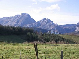
140:Aitz Txiki seen from the north, beside
274:From Atxarte 290 metres (951 ft)
7:
48:adding citations to reliable sources
331:range, and forms part of the same
14:
385:From Atxarte (1h 30m): from the
134:
20:
441:(includes maps and many photos)
409:soon left to reach the col of
327:It is the smallest peak of the
284:Aitz Txiki south face, beside
1:
500:
160:791 m (2,595 ft)
133:
198:43.1185222°N 2.6279278°W
170:91 m (299 ft)
293:
203:43.1185222; -2.6279278
283:
335:mass that forms the
44:improve this article
474:Mountains of Biscay
439:Astxiki at wikineos
194: /
451:2015-05-25 at the
294:
150:Highest point
393:goes the road to
278:
277:
124:
123:
116:
98:
491:
479:Basque Mountains
420:, from here the
360:Sorginkobetagana
270:
256:Basque mountains
251:
219:Language of name
209:
208:
206:
205:
204:
199:
195:
192:
191:
190:
187:
138:
126:
119:
112:
108:
105:
99:
97:
56:
24:
16:
499:
498:
494:
493:
492:
490:
489:
488:
464:
463:
453:Wayback Machine
434:
383:
325:
268:
249:
202:
200:
196:
193:
188:
185:
183:
181:
180:
145:
120:
109:
103:
100:
57:
55:
41:
25:
12:
11:
5:
497:
495:
487:
486:
481:
476:
466:
465:
462:
461:
455:
442:
433:
432:External links
430:
382:
379:
324:
321:
305:Basque Country
276:
275:
272:
264:
263:
259:
258:
253:
245:
244:
235:
231:
230:
226:
225:
220:
216:
215:
211:
210:
178:
172:
171:
168:
162:
161:
158:
152:
151:
147:
146:
139:
131:
130:
122:
121:
28:
26:
19:
13:
10:
9:
6:
4:
3:
2:
496:
485:
482:
480:
477:
475:
472:
471:
469:
460:
456:
454:
450:
447:
443:
440:
436:
435:
431:
429:
427:
423:
419:
414:
412:
408:
404:
400:
396:
392:
388:
380:
378:
376:
375:rock climbing
371:
369:
365:
361:
357:
353:
349:
344:
342:
338:
334:
330:
322:
320:
318:
314:
310:
306:
302:
299:is a peak of
298:
291:
287:
282:
273:
271:
269:Easiest route
265:
260:
257:
254:
252:
246:
243:
239:
236:
232:
227:
224:
221:
217:
212:
207:
189:02°37′40.54″W
186:43°07′06.68″N
179:
177:
173:
169:
167:
163:
159:
157:
153:
148:
143:
137:
132:
127:
118:
115:
107:
104:February 2021
96:
93:
89:
86:
82:
79:
75:
72:
68:
65: –
64:
60:
59:Find sources:
53:
49:
45:
39:
38:
34:
29:This article
27:
23:
18:
17:
459:Las montañas
425:
418:Devil's Pass
417:
415:
410:
406:
398:
394:
386:
384:
372:
363:
359:
355:
347:
345:
326:
316:
312:
296:
295:
289:
250:Parent range
110:
101:
91:
84:
77:
70:
63:"Aitz Txiki"
58:
42:Please help
30:
352:Untxillaitz
323:Description
201: /
176:Coordinates
468:Categories
397:until the
389:parish of
297:Aitz Txiki
166:Prominence
129:Aitz Txiki
74:newspapers
373:The main
333:limestone
229:Geography
156:Elevation
31:does not
449:Archived
446:Mendikat
395:Mendiola
391:Abadiano
387:Zelaieta
339:and the
319:=small.
262:Climbing
234:Location
422:Alluitz
407:Asuntze
399:Atxarte
381:Ascents
364:Atxarte
348:Atxarte
341:Alluitz
329:Urkiola
286:Alluitz
142:Alluitz
88:scholar
52:removed
37:sources
426:Artola
411:Artola
368:castle
356:Artxua
337:Anboto
315:=rock
301:Biscay
290:Artola
238:Biscay
223:Basque
214:Naming
90:
83:
76:
69:
61:
457:(es)
444:(es)
437:(es)
317:txiki
309:Spain
292:col).
242:Spain
95:JSTOR
81:books
313:aitz
67:news
35:any
33:cite
405:of
403:col
358:or
46:by
470::
343:.
303:,
240:,
307:(
144:.
117:)
111:(
106:)
102:(
92:·
85:·
78:·
71:·
54:.
40:.
Text is available under the Creative Commons Attribution-ShareAlike License. Additional terms may apply.