31:
471:
436:
455:
51:
489:
78:
58:
358:. There were 330 households, comprising 363 males and 366 females, giving a sex ratio of 0.99 males per female. The median age was 57.9 years (compared with 37.4 years nationally), with 78 people (10.7%) aged under 15 years, 63 (8.6%) aged 15 to 29, 333 (45.7%) aged 30 to 64, and 255 (35.0%) aged 65 or older.
398:
Of those at least 15 years old, 159 (24.4%) people had a bachelor's or higher degree, and 90 (13.8%) people had no formal qualifications. The median income was $ 28,100, compared with $ 31,800 nationally. 84 people (12.9%) earned over $ 70,000 compared to 17.2% nationally. The employment status of
435:
282:
The Akaroa
Harbour statistical area covers the settlements around the harbour with the exception of Akaroa. It covers 162.14 km (62.60 sq mi). It had an estimated population of 720 as of June 2023, with a population density of 4.4 people per km.
454:
883:
421:
As of 2011, of the seven sites that are sampled in the harbour for water quality, six are graded as "good" and one as "fair" in terms of recreational use. Rainfall affects the grading.
470:
204:
region of New
Zealand. The harbour enters from the southern coast of the peninsula, heading in a predominantly northerly direction. It is one of two major inlets in
913:
918:
105:
873:
799:
648:
153:
746:
923:
399:
those at least 15 was that 279 (42.9%) people were employed full-time, 132 (20.3%) were part-time, and 3 (0.5%) were unemployed.
693:
383:
Although some people chose not to answer the census's question about religious affiliation, 49.4% had no religion, 39.9% were
271:
50:
270:, Barrys Bay, French Farm and Wainui lie on the shoreline of the harbour. They are connected to the rest of Canterbury via
488:
933:
446:
384:
840:
587:
908:
511:
30:
892:
804:
408:
392:
370:
355:
351:
347:
209:
201:
771:
887:
775:
617:
415:
724:
672:
374:
869:
230:
The harbour was used commercially in the mid-19th century for ship-based and shore-based whaling.
237:
36:
274:. French Bay, the site of the French settlement of Akaroa, was originally known as Paka Ariki.
644:
478:
442:
388:
224:
213:
819:
Growth, Structure and
Evolution the Lyttelton Volcanic Complex, Banks Peninsula, New Zealand
928:
531:
205:
197:
91:
366:
494:
219:
The name Akaroa is an alternative spelling of
Whakaroa, Whangaroa or Wangaloa from the
77:
902:
263:
174:
137:
719:
697:
664:
595:
362:
220:
638:
380:
The percentage of people born overseas was 21.0, compared with 27.1% nationally.
817:
377:, and 2.5% other ethnicities. People may identify with more than one ethnicity.
259:
231:
170:
558:
120:
107:
445:(right / northwest) in the Banks Peninsula Volcano, viewed in 2006 from the
267:
252:
Akaroa
Harbour's waterfront has been continually inhabited since the 1840s.
178:
418:
was given approval in 2013 after a 17-year campaign to get it established.
844:
300:
623:
255:
234:
occasionally enter the harbour, with the passengers visiting Akaroa.
166:
142:
407:
The harbour is one of two eroded volcanic centres from the extinct
461:
241:
566:
536:
802:. Statistics New Zealand. March 2020. Akaroa Harbour (333300).
460:
Ships in Akaroa
Harbour in the early 19th century. Some Maori
696:. Christchurch City Council. 2 November 2011. Archived from
295:
240:
is at the head of the harbour, the former site of a Māori
184:
162:
152:
148:
136:
97:
87:
23:
35:A photo of Akaroa Harbour from the northwest with
616:Jacobson, H. C. (1914). "Inside Akaroa Harbour".
354:, and an increase of 18 people (2.5%) since the
98:
843:. Environment Canterbury. 2011. Archived from
794:
792:
640:The Reed Dictionary of New Zealand Place Names
346:Akaroa Harbour had a population of 729 at the
8:
800:"Statistical area 1 dataset for 2018 Census"
350:, a decrease of 27 people (−3.6%) since the
286:
895:(Akaroa Harbour Marine Protection Society)
822:, University of Canterbury, pp. 1–311
637:Reed, Alexander Wyclif (23 January 2002).
285:
20:
805:2018 Census place summary: Akaroa Harbour
874:Te Ara: The Encyclopedia of New Zealand
523:
431:
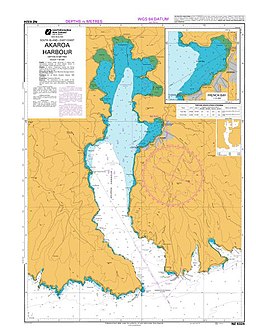
82:Nautical chart "NZ 6324 Akaroa Harbour"
772:"Population estimate tables - NZ.Stat"
57:
841:"Recreational Water Quality Map 2011"
7:
884:Akaroa Harbour Issues Working Party
914:Geography of the Canterbury Region
626:: Akaroa Mail Office. p. 375.
441:Akaroa Harbour (left / south) and
14:
919:Ports and harbours of New Zealand
720:"Akaroa Waterfront Historic Area"
665:"Akaroa Waterfront Historic Area"
482:in Akaroa Harbour. (October 2010)
227:. Whakaroa means "Long Harbour".
487:
469:
453:
434:
361:Ethnicities were 93.8% European/
76:
56:
49:
29:
878:An Encyclopaedia of New Zealand
403:Geography and Natural Features
395:and 1.2% had other religions.
1:
414:The 475-hectare (1,170-acre)
86:
212:, New Zealand; the other is
447:International Space Station
121:43.8446000°S 172.92519972°E
950:
870:Akaroa and Akaroa Harbour
339:
313:—
126:-43.8446000; 172.92519972
75:
44:
28:
876:(published in the 1966
816:Hampton, Samuel (2010),
747:"ArcGIS Web Application"
619:Tales of Banks Peninsula
512:Coastline of New Zealand
924:Calderas of New Zealand
751:statsnz.maps.arcgis.com
559:"New Zealand Gazetteer"
409:Banks Peninsula Volcano
389:Māori religious beliefs
348:2018 New Zealand census
216:on the northern coast.
888:Environment Canterbury
776:Statistics New Zealand
563:gazetteer.linz.govt.nz
464:are in the foreground.
16:Harbour in New Zealand
416:Akaroa Marine Reserve
287:Historical population
725:Heritage New Zealand
694:"Cruise ship visits"
673:Heritage New Zealand
893:Save Akaroa Harbour
669:www.heritage.org.nz
288:
117: /
934:Submarine calderas
208:, on the coast of
479:Sapphire Princess
443:Lyttelton Harbour
344:
343:
214:Lyttelton Harbour
191:
190:
941:
857:
856:
854:
852:
837:
831:
830:
829:
827:
813:
807:
803:
796:
787:
786:
784:
782:
768:
762:
761:
759:
757:
743:
737:
736:
734:
732:
716:
710:
709:
707:
705:
690:
684:
683:
681:
679:
661:
655:
654:
634:
628:
627:
613:
607:
606:
604:
602:
584:
578:
577:
575:
573:
555:
549:
548:
546:
544:
532:"Akaroa Harbour"
528:
491:
473:
457:
438:
302:
297:
289:
272:State Highway 75
132:
131:
129:
128:
127:
122:
118:
115:
114:
113:
110:
100:
80:
60:
59:
53:
33:
21:
949:
948:
944:
943:
942:
940:
939:
938:
909:Banks Peninsula
899:
898:
866:
861:
860:
850:
848:
839:
838:
834:
825:
823:
815:
814:
810:
798:
797:
790:
780:
778:
770:
769:
765:
755:
753:
745:
744:
740:
730:
728:
718:
717:
713:
703:
701:
692:
691:
687:
677:
675:
663:
662:
658:
651:
636:
635:
631:
615:
614:
610:
600:
598:
586:
585:
581:
571:
569:
557:
556:
552:
542:
540:
530:
529:
525:
520:
508:
503:
502:
501:
498:
492:
483:
474:
465:
458:
449:
439:
427:
405:
280:
250:
238:Ōnawe Peninsula
206:Banks Peninsula
198:Banks Peninsula
125:
123:
119:
116:
112:172°55′30.719″E
111:
108:
106:
104:
103:
92:Banks Peninsula
83:
71:
70:
69:
68:
67:
66:
65:
61:
40:
39:clearly visible
37:Ōnawe Peninsula
17:
12:
11:
5:
947:
945:
937:
936:
931:
926:
921:
916:
911:
901:
900:
897:
896:
890:
881:
865:
864:External links
862:
859:
858:
847:on 23 May 2012
832:
808:
788:
763:
738:
711:
700:on 16 May 2012
685:
656:
649:
643:. Reed Books.
629:
608:
579:
550:
522:
521:
519:
516:
515:
514:
507:
504:
500:
499:
497:of the harbour
495:Holding ground
493:
486:
484:
475:
468:
466:
459:
452:
450:
440:
433:
430:
429:
428:
426:
423:
404:
401:
342:
341:
337:
336:
333:
330:
326:
325:
322:
319:
315:
314:
311:
308:
304:
303:
298:
293:
279:
276:
249:
246:
194:Akaroa Harbour
189:
188:
186:
182:
181:
164:
160:
159:
156:
150:
149:
146:
145:
140:
134:
133:
101:
95:
94:
89:
85:
84:
81:
73:
72:
64:Akaroa Harbour
63:
62:
55:
54:
48:
47:
46:
45:
42:
41:
34:
26:
25:
24:Akaroa Harbour
15:
13:
10:
9:
6:
4:
3:
2:
946:
935:
932:
930:
927:
925:
922:
920:
917:
915:
912:
910:
907:
906:
904:
894:
891:
889:
885:
882:
879:
875:
871:
868:
867:
863:
846:
842:
836:
833:
821:
820:
812:
809:
806:
801:
795:
793:
789:
777:
773:
767:
764:
752:
748:
742:
739:
727:
726:
721:
715:
712:
699:
695:
689:
686:
674:
670:
666:
660:
657:
652:
650:9780790007618
646:
642:
641:
633:
630:
625:
621:
620:
612:
609:
597:
593:
589:
583:
580:
568:
564:
560:
554:
551:
539:
538:
533:
527:
524:
517:
513:
510:
509:
505:
496:
490:
485:
481:
480:
472:
467:
463:
456:
451:
448:
444:
437:
432:
425:Image gallery
424:
422:
419:
417:
412:
410:
402:
400:
396:
394:
390:
386:
381:
378:
376:
372:
368:
364:
359:
357:
353:
349:
338:
334:
331:
328:
327:
323:
320:
317:
316:
312:
309:
306:
305:
299:
294:
291:
290:
284:
277:
275:
273:
269:
265:
261:
257:
253:
247:
245:
243:
239:
235:
233:
228:
226:
222:
217:
215:
211:
207:
203:
199:
195:
187:
183:
180:
176:
172:
168:
165:
161:
158:The Long Boat
157:
155:
151:
147:
144:
141:
139:
135:
130:
109:43°50′40.56″S
102:
96:
93:
90:
79:
74:
52:
43:
38:
32:
27:
22:
19:
877:
849:. Retrieved
845:the original
835:
824:, retrieved
818:
811:
779:. Retrieved
766:
754:. Retrieved
750:
741:
729:. Retrieved
723:
714:
702:. Retrieved
698:the original
688:
676:. Retrieved
668:
659:
639:
632:
618:
611:
599:. Retrieved
592:Kā Huru Manu
591:
582:
570:. Retrieved
562:
553:
541:. Retrieved
535:
526:
477:
420:
413:
406:
397:
391:, 0.8% were
382:
379:
360:
345:
281:
278:Demographics
254:
251:
236:
232:Cruise ships
229:
218:
193:
192:
18:
826:22 February
387:, 1.2% had
356:2006 census
352:2013 census
260:Duvauchelle
248:Settlements
223:dialect of
196:is part of
171:Duvauchelle
163:Settlements
124: /
99:Coordinates
903:Categories
781:25 October
518:References
264:Takapūneke
210:Canterbury
202:Canterbury
185:References
175:Takapūneke
756:2 January
596:Ngāi Tahu
385:Christian
268:Takamatua
179:Takamatua
731:26 April
678:26 April
601:26 April
588:"Akaroa"
572:26 April
543:27 April
506:See also
393:Buddhist
371:Pasifika
340:Source:
221:Kāi Tahu
88:Location
373:, 2.5%
369:, 1.2%
365:, 6.6%
301:±% p.a.
200:in the
154:Islands
143:Harbour
929:Akaroa
851:10 May
704:10 May
647:
624:Akaroa
363:Pākehā
335:−0.72%
324:+0.88%
256:Akaroa
167:Akaroa
462:whare
375:Asian
367:Māori
225:Māori
853:2012
828:2019
783:2023
758:2024
733:2020
706:2012
680:2020
645:ISBN
603:2020
574:2020
567:LINZ
545:2020
537:LINZ
476:The
329:2018
318:2013
307:2006
296:Pop.
292:Year
138:Type
886:at
872:at
332:729
321:756
310:711
905::
791:^
774:.
749:.
722:.
671:.
667:.
622:.
594:.
590:.
565:.
561:.
534:.
411:.
266:,
262:,
258:,
244:.
242:pā
177:,
173:,
169:,
880:)
855:.
785:.
760:.
735:.
708:.
682:.
653:.
605:.
576:.
547:.
Text is available under the Creative Commons Attribution-ShareAlike License. Additional terms may apply.