45:
435:
These limestone hills rising to some 1500 m, the ancient Mons
Bargylus or present Jebel Ansariyeh, inhabited by an Alawi population since the Middle Ages, have never been open to archaeological investigation, and remain an almost complete blank in the archaeological and social map of the
178:
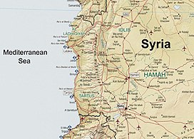
running north–south, parallel to the coastal plain. The mountains have an average width of 32 kilometres (20 mi), and their average peak elevation is just over 1,200 metres (3,900 ft) with the highest peak, Nabi Yunis, reaching 1,562 metres (5,125 ft), east of
113:
527:
428:
631:
554:
356:
598:
183:. In the north the average height declines to 900 metres (3,000 ft), and to 600 metres (2,000 ft) in the south.
106:
613:
449:
Dr. William Smith's
Dictionary of the Bible: comprising its antiquities, biography, geography, and natural history
641:
636:
373:
337:
220:
293:
479:
44:
452:
594:
550:
544:
523:
517:
498:
456:
424:
309:
378:
368:
493:
Forrer, Emil
Orgetorix Gustav (1928). "Barga". In Ebeling, Erich; Meissner, Bruno (eds.).
329:
324:, and then around the northern edge of the range to flow into the Mediterranean. South of
231:
207:
151:
473:
211:
17:
625:
352:
333:
313:
256:
403:
312:
and are thus more fertile and more heavily populated than the eastern slopes. The
588:
571:
317:
191:
351:
Between 1920 and 1936, the mountains formed parts of the eastern border of the
234:
most probably located in the vicinity of the mountains; it was a city of the
128:
115:
296:
which has traditionally lived there, though the former term is based on an
502:
460:
345:
297:
290:
239:
187:
174:(Ansari, Nusayri or Alawi Mountains) is a mountain range in northwestern
341:
180:
519:
Eblaitica: Essays on the Ebla
Archives and Eblaite Language, Volume 4
325:
321:
68:
238:
Empire in the third millennium BC, and then a vassal kingdom of the
497:(in German). Vol. 1. Walter de Gruyter & Co. p. 401.
423:. Cambridge, Massachusetts: Harvard University Press. p. 17.
175:
99:
451:(Volume IV, Regum-Melech to Zuzims) Hurd and Houghton, New York,
235:
230:) had its roots in the name of an ancient city-kingdom called
590:
A House of Many
Mansions: The History of Lebanon Reconsidered
516:
Cyrus Herzl Gordon; Gary
Rendsburg; Nathan H. Winter (2002).
316:
flows north alongside the range on its eastern verge in the
475:
Dictionary of Greek and Roman
Geography: Iabadius-Zymethus
546:
Ugarit in
Retrospect: Fifty Years of Ugarit and Ugaritic
332:
which separates An-Nusayriyah
Mountain from the coastal
308:
The western slopes catch moisture-laden winds from the
402:
Federal
Research Division, Library of Congress (2005)
300:
for the community that is now considered insulting.
225:
105:
95:
90:
82:
77:
67:
59:
54:
32:
398:
396:
394:
573:The International Standard Bible Encyclopaedia
8:
281:
268:
250:
242:, who named the mountain range after Barga.
29:
245:In the medieval period were known as the
202:Classically, this range was known as the
186:This mountain range has been home to an
390:
259:. They are also sometimes known as the
478:. Little, Brown and Company. p.
328:there is a large northeast-southwest
7:
447:Hackett, Horatio B. (editor) (1870)
414:
412:
289:); both of these names refer to the
282:
269:
251:
155:
25:
421:The Roman Near East: 31 BC–AD 337
357:Mandate for Syria and the Lebanon
43:
614:Encyclopædia Britannica – Syria
320:, a 64 kilometres (40 mi)
160:Silsilat al-Jibāl as-Sāḥilīyah
1:
543:Gordon Douglas Young (1981).
419:Millar, Fergus (1995-03-15).
33:Syrian Coastal Mountain Range
576:. Vol. 3. p. 1400.
495:Reallexikon der Assyriologie
344:, in a feature known as the
73:1,562 m (5,125 ft)
226:
658:
255:) after the Arab tribe of
215:
42:
37:
632:Mountain ranges of Syria
404:"Country Profile: Syria"
86:150 km (93 mi)
593:. Londo: I. B. Tauris.
27:Mountain range in Syria
587:Salibi, Kamal (2005).
472:William Smith (1857).
374:Wildlife of the Levant
338:Anti-Lebanon Mountains
206:, a name mentioned by
148:Coastal Mountain Range
49:Coastal Mountain Range
18:Al-Ansariyah mountains
156:سلسلة الجبال الساحلية
38:سلسلة الجبال الساحلية
294:ethnoreligious group
261:Nusayriyah Mountains
322:longitudinal trench
274:Jibāl an-Nuṣayriyah
125: /
570:James Orr (1930).
355:within the French
287:Jibāl al-‘Alawīyin
278:Alawiyin Mountains
265:Ansarieh Mountains
188:Alawite population
172:Jabal al-`Alawīyin
55:Highest point
529:978-1-57506-060-6
430:978-0-674-77886-3
330:strike-slip fault
310:Mediterranean Sea
224:
168:Jabal an-Nusayria
164:Jabal al-Ansariya
144:
143:
107:Range coordinates
16:(Redirected from
649:
642:Homs Governorate
637:Hama Governorate
616:
611:
605:
604:
584:
578:
577:
567:
561:
560:
540:
534:
533:
513:
507:
506:
490:
484:
483:
469:
463:
445:
439:
438:
416:
407:
400:
379:Lake 16 Teshreen
369:Turkmen Mountain
298:antiquated label
285:
284:
272:
271:
254:
253:
229:
219:
217:
157:
140:
139:
137:
136:
135:
130:
126:
123:
122:
121:
118:
47:
30:
21:
657:
656:
652:
651:
650:
648:
647:
646:
622:
621:
620:
619:
612:
608:
601:
586:
585:
581:
569:
568:
564:
557:
549:. p. 227.
542:
541:
537:
530:
522:. p. 121.
515:
514:
510:
492:
491:
487:
471:
470:
466:
446:
442:
431:
418:
417:
410:
401:
392:
387:
365:
306:
208:Pliny the Elder
200:
133:
131:
129:35.60°N 36.24°E
127:
124:
119:
116:
114:
112:
111:
50:
28:
23:
22:
15:
12:
11:
5:
655:
653:
645:
644:
639:
634:
624:
623:
618:
617:
606:
599:
579:
562:
555:
535:
528:
508:
485:
464:
440:
429:
408:
406:(PDF), page 5.
389:
388:
386:
383:
382:
381:
376:
371:
364:
361:
305:
302:
199:
196:
162:) also called
142:
141:
109:
103:
102:
97:
93:
92:
88:
87:
84:
80:
79:
75:
74:
71:
65:
64:
61:
57:
56:
52:
51:
48:
40:
39:
35:
34:
26:
24:
14:
13:
10:
9:
6:
4:
3:
2:
654:
643:
640:
638:
635:
633:
630:
629:
627:
615:
610:
607:
602:
596:
592:
591:
583:
580:
575:
574:
566:
563:
558:
556:9780931464072
552:
548:
547:
539:
536:
531:
525:
521:
520:
512:
509:
504:
500:
496:
489:
486:
481:
477:
476:
468:
465:
462:
458:
454:
450:
444:
441:
437:
432:
426:
422:
415:
413:
409:
405:
399:
397:
395:
391:
384:
380:
377:
375:
372:
370:
367:
366:
362:
360:
358:
354:
353:Alawite State
349:
347:
343:
339:
335:
334:Mount Lebanon
331:
327:
323:
319:
315:
314:Orontes River
311:
303:
301:
299:
295:
292:
288:
283:جبال العلويين
279:
275:
270:جبال النصيرية
266:
262:
258:
248:
243:
241:
237:
233:
228:
222:
213:
209:
205:
197:
195:
193:
189:
184:
182:
177:
173:
169:
165:
161:
153:
149:
138:
110:
108:
104:
101:
98:
94:
89:
85:
81:
76:
72:
70:
66:
62:
58:
53:
46:
41:
36:
31:
19:
609:
589:
582:
572:
565:
545:
538:
518:
511:
494:
488:
474:
467:
448:
443:
434:
420:
350:
307:
286:
277:
273:
264:
260:
246:
244:
203:
201:
185:
171:
167:
163:
159:
147:
145:
134:35.60; 36.24
318:Ghab valley
247:Jabal Bahra
192:Middle Ages
132: /
626:Categories
600:1860649122
385:References
216:Μπάργκυλος
190:since the
78:Dimensions
63:Nabi Yunis
461:325913985
453:page 3142
304:Geography
276:) or the
252:جبل بهراء
221:romanized
91:Geography
69:Elevation
363:See also
346:Homs Gap
336:and the
240:Hittites
227:Bargylus
204:Bargylus
96:Location
436:region.
342:Lebanon
263:or the
236:Eblaite
223::
181:Latakia
120:36°14′E
117:35°36′N
597:
553:
526:
503:718866
501:
459:
427:
326:Masyaf
257:Bahra’
210:. The
152:Arabic
83:Length
291:Alawi
232:Barga
212:Greek
176:Syria
100:Syria
595:ISBN
551:ISBN
524:ISBN
499:OCLC
480:1071
457:OCLC
425:ISBN
198:Name
146:The
60:Peak
340:of
170:or
628::
455:,
433:.
411:^
393:^
359:.
348:.
218:,
214::
194:.
166:,
158:,
154::
603:.
559:.
532:.
505:.
482:.
280:(
267:(
249:(
150:(
20:)
Text is available under the Creative Commons Attribution-ShareAlike License. Additional terms may apply.