250:(A very large farm or ranch greater than 8000 acres (32 km²)) can be seen on the Mt Nessing Golf Club's course. Water for the Albury Scheme is taken from a tributary branch of the Opawa River. This scheme was built in the late 1960s/early 1970s and uses no pumps - the system is driven by gravity. It was served by one low dam until 2000-2002 when another branch of the river was dammed to increase the water flow to the headworks. This was necessary as water flow was becoming too low in the original branch. Filtering for the scheme is performed by a long, dual channel trough that contains various grade of gravel with the coarsest at the bottom (
44:
266:
293:
278:
51:
245:
comes from the
Downlands scheme. Most of the district is served by the Albury Rural Water Scheme that supplies water for both stock and homesteads. Prior to these schemes houses would pump water from the rivers, or get it from an open water race that was built for stock and human use. Remnants of the
232:
Albury School is a co-educational state primary school covering years 1 to 6, with a roll of 30 as of August 2024. The school was founded in 1882. It currently has two classrooms, one for years 1 and 2 and one for years 3 to 6. Most children go on to the high school in
Fairlie (Mackenzie College).
220:
opened on 24 August 1883. Although the
Fairlie Branch closed on 2 March 1968, some formation from the line can still be seen around Albury. Albury is thought to have been named by the
328:
Every year around March/April the Albury Pub/Tavern/Bar is the destination of a mountain bicycle race. The race is called the "Pass to Pub". The race goes for about 35 km from
128:
349:
809:
292:
553:
732:
43:
72:
265:
742:
727:
417:
247:
205:
Albury is located in a rural farming district, and for over six years in the 19th century served as the temporary terminus of the
546:
353:
277:
686:
681:
804:
783:
539:
242:
179:
175:
254:). Little maintenance is required apart from periodic flushing of the filter by flowing water backwards through it.
773:
449:
747:
332:
to the Albury Tavern. Local organisations put on barbecues and sell items for fundraising activities at the end.
437:
194:
163:
651:
217:
575:
737:
641:
636:
579:
284:
183:
757:
671:
778:
752:
605:
600:
562:
187:
299:
390:(New Zealand Railways Department: Place of publication within New Zealand unknown, 1957), 19.
701:
221:
706:
213:
798:
711:
167:
531:
141:
696:
691:
676:
631:
566:
329:
251:
206:
413:
216:. The line was opened on 1 January 1877 and an extension beyond the town to
87:
74:
646:
377:, fourth edition, edited by John Yonge (Essex: Quail Map Company, 1993), 24.
471:
209:
610:
171:
506:
521:
516:
526:
350:"2013 Census map - Quickstats about a place - Meshblock 2804800"
151:
535:
501:
496:
193:
The population of Albury was 66 people in 27 households in the
136:
511:
403:, revised edition (Wellington: Grantham House, 1998 ), 79-80.
319:
Rural Women (Formerly Women's
Division of Federated Farmers)
241:
The water supply for the village and those close to
766:
720:
664:
619:
593:
586:
147:
134:
124:
116:
111:
103:
23:
162:is a small village in the southern part of the
352:. Statistics New Zealand. 2013. Archived from
547:
8:
502:Albury Tavern and Nana's Backpackers website
590:
554:
540:
532:
20:
810:Populated places in the Canterbury Region
522:New Zealand Sheep Dog Trial Association
341:
261:
146:
133:
110:
102:
67:
36:
401:Exploring New Zealand's Ghost Railways
375:New Zealand Railway and Tramway Atlas
283:Looking from Mt Nessing area towards
123:
115:
7:
452:. New Zealand Ministry of Education
170:of New Zealand. It is inland from
298:Looking from Mt Nessing area with
186:. It is in the Mackenzie Country (
117: • Territorial Authority
14:
743:Mount John University Observatory
728:Aoraki / Mount Cook National Park
507:Opawa Homestead Bed and Breakfast
418:Ministry for Culture and Heritage
386:New Zealand Railways Department,
497:Albury School's official website
291:
276:
264:
246:water race supplying Mt Nessing
49:
42:
450:"New Zealand Schools Directory"
438:Education Counts: Albury School
399:David Leitch and Brian Scott,
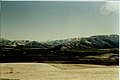
271:Taken from hills NE of Albury.
50:
1:
308:Local Clubs and Organisations
125: • Regional council
733:Church of the Good Shepherd
212:line that would become the
826:
721:Facilities and attractions
388:Geographical Mileage Table
152:Mackenzie District Council
120:Mackenzie District Council
748:Lake Tekapo Regional Park
573:
517:New Zealand Young Farmers
313:Mount Nessing Collie Club
68:
37:
30:
527:Mackenzie County Council
512:Rural Women New Zealand
316:Mount Nessing Golf Club
195:2013 New Zealand census
129:Environment Canterbury
88:44.23056°S 170.87389°E
18:Village in New Zealand
738:Mount Cook Aerodrome
601:Lake Tekapo township
93:-44.23056; 170.87389
758:The Hermitage Hotel
672:Aoraki / Mount Cook
665:Geographic features
84: /
805:Mackenzie District
753:Roundhill Ski Area
606:Mount Cook Village
563:Mackenzie District
188:Mackenzie District
792:
791:
660:
659:
300:Aoraki/Mount Cook
222:Kennaway brothers
157:
156:
817:
784:Regional Council
774:District Council
687:Lake Alexandrina
591:
587:Populated places
556:
549:
542:
533:
484:
483:
481:
479:
468:
462:
461:
459:
457:
446:
440:
435:
429:
428:
426:
424:
410:
404:
397:
391:
384:
378:
372:
366:
365:
363:
361:
356:on 9 August 2019
346:
295:
280:
268:
99:
98:
96:
95:
94:
89:
85:
82:
81:
80:
77:
53:
52:
46:
21:
825:
824:
820:
819:
818:
816:
815:
814:
795:
794:
793:
788:
762:
716:
702:Mackenzie Basin
656:
615:
582:
569:
560:
493:
488:
487:
477:
475:
474:. Albury School
470:
469:
465:
455:
453:
448:
447:
443:
436:
432:
422:
420:
412:
411:
407:
398:
394:
385:
381:
373:
369:
359:
357:
348:
347:
343:
338:
326:
310:
303:
302:in the distance
296:
287:
281:
272:
269:
260:
258:Picture gallery
239:
230:
203:
176:State Highway 8
174:and located on
92:
90:
86:
83:
78:
75:
73:
71:
70:
64:
63:
62:
61:
60:
59:
58:
54:
33:
26:
19:
12:
11:
5:
823:
821:
813:
812:
807:
797:
796:
790:
789:
787:
786:
781:
776:
770:
768:
764:
763:
761:
760:
755:
750:
745:
740:
735:
730:
724:
722:
718:
717:
715:
714:
709:
707:Tasman Glacier
704:
699:
694:
689:
684:
682:Hooker Glacier
679:
674:
668:
666:
662:
661:
658:
657:
655:
654:
649:
644:
639:
634:
629:
623:
621:
617:
616:
614:
613:
608:
603:
597:
595:
588:
584:
583:
574:
571:
570:
561:
559:
558:
551:
544:
536:
530:
529:
524:
519:
514:
509:
504:
499:
492:
491:External links
489:
486:
485:
463:
441:
430:
405:
392:
379:
367:
340:
339:
337:
334:
325:
322:
321:
320:
317:
314:
309:
306:
305:
304:
297:
290:
288:
282:
275:
273:
270:
263:
259:
256:
238:
235:
229:
226:
214:Fairlie Branch
202:
199:
180:Pleasant Point
166:region of the
155:
154:
149:
145:
144:
139:
132:
131:
126:
122:
121:
118:
114:
113:
109:
108:
105:
101:
100:
66:
65:
56:
55:
48:
47:
41:
40:
39:
38:
35:
34:
31:
28:
27:
24:
17:
13:
10:
9:
6:
4:
3:
2:
822:
811:
808:
806:
803:
802:
800:
785:
782:
780:
777:
775:
772:
771:
769:
765:
759:
756:
754:
751:
749:
746:
744:
741:
739:
736:
734:
731:
729:
726:
725:
723:
719:
713:
710:
708:
705:
703:
700:
698:
695:
693:
690:
688:
685:
683:
680:
678:
675:
673:
670:
669:
667:
663:
653:
650:
648:
645:
643:
640:
638:
635:
633:
630:
628:
625:
624:
622:
618:
612:
609:
607:
604:
602:
599:
598:
596:
592:
589:
585:
581:
577:
572:
568:
564:
557:
552:
550:
545:
543:
538:
537:
534:
528:
525:
523:
520:
518:
515:
513:
510:
508:
505:
503:
500:
498:
495:
494:
490:
473:
467:
464:
451:
445:
442:
439:
434:
431:
419:
415:
409:
406:
402:
396:
393:
389:
383:
380:
376:
371:
368:
355:
351:
345:
342:
335:
333:
331:
323:
318:
315:
312:
311:
307:
301:
294:
289:
286:
279:
274:
267:
262:
257:
255:
253:
249:
244:
236:
234:
227:
225:
223:
219:
215:
211:
208:
200:
198:
196:
191:
189:
185:
181:
177:
173:
169:
165:
161:
153:
150:
143:
140:
138:
130:
127:
119:
106:
97:
69:Coordinates:
45:
29:
22:
16:
712:Tekapo River
626:
476:. Retrieved
466:
456:17 September
454:. Retrieved
444:
433:
421:. Retrieved
408:
400:
395:
387:
382:
374:
370:
358:. Retrieved
354:the original
344:
327:
324:Local Events
240:
237:Water supply
231:
204:
192:
168:South Island
159:
158:
15:
697:Lake Tekapo
692:Lake Pukaki
677:Burkes Pass
632:Burkes Pass
594:Pukaki Ward
567:New Zealand
423:18 February
330:Burkes Pass
252:Sand Filter
107:New Zealand
91: /
79:170°52′26″E
799:Categories
767:Government
620:Opuha Ward
472:"About Us"
336:References
164:Canterbury
112:Government
76:44°13′50″S
652:Winscombe
647:Raincliff
478:30 August
360:30 August
228:Education
218:Winscombe
142:Ngāi Tahu
414:"Albury"
178:between
642:Kimbell
637:Fairlie
580:Fairlie
285:Fairlie
248:Station
210:railway
201:History
184:Fairlie
148:Website
104:Country
32:Village
627:Albury
611:Twizel
207:branch
172:Timaru
160:Albury
135:Local
57:Albury
25:Albury
779:Mayor
576:Seat
480:2019
458:2024
425:2015
362:2019
182:and
243:SH8
190:).
137:iwi
801::
578::
565:,
416:.
224:.
197:.
555:e
548:t
541:v
482:.
460:.
427:.
364:.
Text is available under the Creative Commons Attribution-ShareAlike License. Additional terms may apply.