515:
371:
36:
1520:
275:
514:
334:
and is very rugged, with peaks reaching more than 6,100 metres (20,000 ft) and many perennial snow fields. The central portion is lower in elevation, around 4,000 metres (13,000 ft). The eastern portion is higher in elevation, about 5,000 metres (16,000 ft) and consists of a group of
357:
The southwestern part of the Altyn-Tagh range reaches snowy peaks of up to 6,245 metres (20,489 ft), although it descends to an average of 4,000 metres (13,000 ft) in the narrow middle and eventually rises up to average 5,000 metres (16,000 ft) as it meets the Qilian
Mountains.
361:
There are a dearth of rivers and streams in these mountains, due to the aridity of the region. The western portion has some small streams that either head north into the desert or south into Lake
Ayakkum. The remainder of the range is lacking in rivers.
612:) for this place name, "Kumukuli Basin" is often used in English. When trying to produce a Turkic-like spelling for this name, authors occasionally transcribe it as "Kumukol Basin", as in the map in Fig. 2 in Meng & Fang's
1017:
458:; 37°30′N, 89°30′E; elevation 3,876 metres (12,717 ft)). These lakes are two of the few noticeable bodies of water in this extremely arid area; the area around them is officially protected as the
1045:
475:
starts between the Altyn-Tagh and the Kunlun and extends almost to the east side of the plateau; the Altyn-Tagh separates the west side of this basin from the
1542:
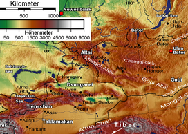
298:, the Altyn-Tagh Range diverges northeast while the Kunluns continue directly east, forming a relatively narrow "V". Inside the "V" are a number of
782:
354:
ends and the Silk Road splits. One branch follows the Altyn-Tagh along the south side of the Tarim Basin while the other follows the north side.
1038:
1001:
976:
939:
904:
852:
1552:
236:
Altun Shan is also the name of a 5,830 metres (19,130 ft) mountain near the eastern end of the range, the highest point in Gansu.
766:
1547:
1054:
1031:
873:
806:
159:
821:
76:
152:
69:
1523:
536:
crosses the Altyn-Tagh as well. The project, involving the construction of the 13.195 km-long Altyn-Tagh Tunnel (
493:
1226:
526:
460:
350:('south mountains') because they were south of the main route. Near the east end of the Altyn-Shan, the Gansu or
773:(The first tunnel of the Xinjiang section of the Golmud-Korla Railway has been drilled through), 2017-10-31
499:
378:
Inside the V-shaped area between the Altyn-Tagh and the main Kunlun range (which in this area is called
213:(also Lower Mountains or Altyn ) is a mountain range in Northwestern China that separates the Eastern
1339:
1103:
533:
488:
1351:
1238:
1206:
390:
319:
303:
1495:
1413:
1293:
1253:
1232:
1220:
1149:
1098:
1071:
1063:
370:
330:, to the south. The range can be divided into three portions. The southwest portion borders the
379:
1507:
1502:
1485:
1475:
1452:
1425:
1420:
1368:
1345:
1243:
1086:
997:
972:
966:
935:
900:
884:
869:
863:
848:
847:. Vol. I: A-Ak – Bayes (15th ed.). Chicago, Illinois: Encyclopædia Britannica, Inc.
802:
503:
1447:
1435:
1408:
1194:
1122:
1111:
927:
915:
892:
558:
441:
419:
394:
347:
331:
323:
291:
259:
1490:
1480:
1403:
1361:
1298:
1283:
1275:
1258:
1248:
1169:
1129:
1080:
770:
763:
581:
299:
287:
249:
218:
574:
1430:
1398:
1373:
1332:
1303:
1288:
916:"Cenozoic Tectonic Development of the Qaidam Basin in the Northeastern Tibetan Plateau"
839:
476:
283:
346:
to the Tarim Basin and westward. The Altyn-Tagh and
Qilians were sometimes called the
35:
1536:
1470:
1383:
1327:
1263:
1164:
1144:
817:
614:
Cenozoic tectonic development of the Qaidam Basin in the northeastern
Tibetan Plateau
598:
Cenozoic tectonic development of the Qaidam Basin in the northeastern
Tibetan Plateau
415:
351:
1134:
519:
472:
343:
327:
891:. GeoJournal library. Vol. 57. Springer Science + Business Media Dordrecht.
1462:
1315:
1212:
502:(6,065 metres (19,898 ft)), Altun Shan (5,830 metres (19,130 ft)) and
437:
295:
214:
950:
1319:
1186:
931:
896:
274:
174:
161:
91:
78:
1442:
1356:
1181:
1175:
1158:
1092:
914:
Meng, Qing-Ren; Fang, Xiang (2008). Burchfield, B. C.; Wang, Erchie (eds.).
383:
339:
1023:
307:
222:
137:
1392:
1200:
468:
226:
141:
889:
Mountain
Geoecology and Sustainable Development of the Tibetan Plateau
609:
566:
449:
427:
402:
311:
59:
816:
de
Ferranti, Jonathan; Jurgalski, Eberhard; Maizlish, Aaron (2011).
513:
436:; 37°05′N, 88°25′E, 4,250 metres (13,940 ft) elevation) and
369:
315:
273:
230:
199:
145:
529:
crosses the Altyn-Tagh on its way between
Qinghai and Xinjiang.
1027:
389:
Within southeastern
Xinjiang, the main of these basins is the
335:
smaller ranges oriented in a south-east to north-west trend.
968:
An introduction to saline lakes on the
Qinghai-Tibet plateau
752:
29:
Altyn Mountains, Altyn Shan, A'erjin Shan, A-erh-chin Shan
326:. The range separates the Tarim Basin, to the north, and
338:
Along the northern side of the mountains ran the main
868:. Elibron Classic Series. Adamant Media Corporation.
862:
Holdich, Sir Thomas (2006) . Keltie, J. Scott (ed.).
40:
Eastern part of Altun Shan at bottom of elevation map
887:. In Du Zheng, Qingsong Zhang; Wu, Shaohong (eds.).
1461:
1382:
1314:
1274:
1143:
1070:
971:. Monographiae Biologicae. Vol. 76. Springer.
198:
190:
151:
133:
125:
120:
112:
107:
68:
58:
50:
45:
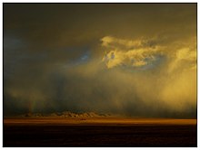
23:
838:
596:See e.g. the map in Fig. 1 in Meng & Fang's
414:The two main lakes in this basin are the saline
302:. The eastern end of the Altyn-Shan is near the
225:while the eastern part forms the border between
1039:
996:. Washington, DC: National Geographic. 2009.
920:Special Paper – Geological Society of America
537:
294:. About halfway across the south side of the
253:
8:
725:
723:
801:. New York, NY: Columbia University Press.
616:, but more often as "Kumkol", or "Kumkuli".
1046:
1032:
1024:
797:Cohen, Saul B., ed. (1998) . "Altunshan".
753:de Ferranti, Jurgalski & Maizlish 2011
741:
715:
20:
679:
667:
926:. Geological Society of America: 1–24.
703:
655:
634:
632:
628:
551:
691:
638:
194:Kunlun Mountains and Qilian Mountains
116:805 km (500 mi) WSW-ENE
7:
651:
649:
647:
1543:Highest points of Chinese provinces
824:from the original on 23 August 2010
799:The Columbia Gazetteer of the World
286:run along the northern edge of the
994:National Geographic Atlas of China
729:
14:
506:(4,800 metres (15,700 ft)).
498:(6,245 metres (20,489 ft)),
1519:
1518:
34:
783:国家重点铁路建设项目格库铁路全线开通 (Dec, 2020))
418:(also Ajig Kum Kul, Achak-kum;
837:Hoiberg, Dale H., ed. (2010).
467:Farther east, in northwestern
454:
432:
407:
229:to the south and Xinjiang and
1:
366:Intermontane endorheic basins
318:. East of the Altyn-Tagh the
64:6,245 m (20,489 ft)
608:The Chinese-based spelling (
54:Sulamutag Feng, Xinjiang
1553:Mountain ranges of Xinjiang
1018:NASA photos of Ayakkum Lake
487:The four highest peaks are
1569:
1227:Nyenchen Tanglha Mountains
542:), was completed in 2020.
527:China National Highway 315
221:. The western third is in
1516:
1061:
897:10.1007/978-94-010-0965-2
562:
538:
461:Altun Shan Nature Reserve
445:
423:
398:
254:
33:
28:
1548:Mountain ranges of Gansu
1055:Mountain ranges of China
965:Zheng, Mianping (1997).
845:Encyclopædia Britannica
769:1 December 2017 at the
840:"A-erh-chin Mountains"
523:
375:
290:. In the west are the
279:
932:10.1130/2008.2444(01)
885:"Nature Conservation"
865:Tibet, the Mysterious
818:"Sinkiang – Xinjiang"
518:Altyn Mountains from
517:
373:
277:
1104:Tarbagatai Mountains
1020:and surrounding area
883:Li, Bosheng (2000).
680:Meng & Fang 2008
668:Meng & Fang 2008
534:Golmud-Korla Railway
510:Economic development
500:Yusupu Aleketag Shan
386:basins are located.
374:Altyn Tagh landscape
314:road in far western
252:, and A'erjin Shan (
1352:Zhongtiao Mountains
1239:Gaoligong Mountains
1207:Bayan Har Mountains
949:Peakbagger (2013).
171: /
88: /
1524:Landforms of China
1496:Yuecheng Mountains
1414:Jingshan Mountains
1294:Changbai Mountains
1254:Qionglai Mountains
1233:Hengduan Mountains
1221:Tanggula Mountains
1099:Borohoro Mountains
1064:Geography of China
732:, pp. 230–231
524:
471:, the much larger
376:
280:
278:Altyn Tagh at dusk
46:Highest point
1530:
1529:
1508:Western Mountains
1503:Longmen Mountains
1486:Nanling Mountains
1476:Daliang Mountains
1453:Xuefeng Mountains
1426:Jiuling Mountains
1421:Luoxiao Mountains
1369:Yandang Mountains
1346:Taihang Mountains
1340:Lüliang Mountains
1244:Yunling Mountains
1087:Dzungarian Alatau
1003:978-1-4262-0327-5
978:978-0-7923-4098-0
941:978-0-8137-2444-7
906:978-94-010-3800-3
854:978-1-59339-837-8
342:trade route from
208:
207:
175:38.600°N 89.000°E
153:Range coordinates
92:37.917°N 87.383°E
1560:
1522:
1521:
1448:Wuling Mountains
1436:Wugong Mountains
1409:Wudang Mountains
1195:Kunlun Mountains
1135:Liupan Mountains
1123:Qilian Mountains
1112:Kunlun Mountains
1048:
1041:
1034:
1025:
1007:
982:
961:
959:
957:
945:
910:
879:
858:
842:
833:
831:
829:
820:. peaklist.com.
812:
785:
780:
774:
761:
755:
750:
744:
739:
733:
727:
718:
713:
707:
701:
695:
689:
683:
677:
671:
665:
659:
653:
642:
636:
617:
606:
600:
594:
588:
579:A-erh-chin Shan;
564:
556:
541:
540:
497:
456:
447:
434:
425:
409:
400:
332:Kunlun Mountains
324:Qilian Mountains
300:endorheic basins
292:Kunlun Mountains
257:
256:
244:Altyn Tag means
186:
185:
183:
182:
181:
176:
172:
169:
168:
167:
164:
103:
102:
100:
99:
98:
93:
89:
86:
85:
84:
81:
38:
21:
1568:
1567:
1563:
1562:
1561:
1559:
1558:
1557:
1533:
1532:
1531:
1526:
1512:
1491:Jiuyi Mountains
1481:Dalou Mountains
1457:
1404:Dabie Mountains
1378:
1362:Tianmu Mountain
1310:
1299:Wanda Mountains
1284:Greater Khingan
1270:
1259:Daxue Mountains
1249:Ailao Mountains
1170:Pamir Mountains
1147:
1139:
1130:Helan Mountains
1081:Altai Mountains
1066:
1057:
1052:
1014:
1004:
992:
989:
987:Further reading
979:
964:
955:
953:
948:
942:
913:
907:
882:
876:
861:
855:
836:
827:
825:
815:
809:
796:
793:
788:
781:
777:
771:Wayback Machine
764:格库铁路新疆段首条隧道顺利贯通
762:
758:
751:
747:
742:Peakbagger 2013
740:
736:
728:
721:
716:Peakbagger 2013
714:
710:
702:
698:
690:
686:
678:
674:
666:
662:
654:
645:
637:
630:
626:
621:
620:
607:
603:
595:
591:
557:
553:
548:
512:
491:
485:
368:
288:Tibetan Plateau
284:mountain ranges
272:
242:
219:Tibetan Plateau
179:
177:
173:
170:
165:
162:
160:
158:
157:
96:
94:
90:
87:
82:
79:
77:
75:
74:
41:
17:
12:
11:
5:
1566:
1564:
1556:
1555:
1550:
1545:
1535:
1534:
1528:
1527:
1517:
1514:
1513:
1511:
1510:
1505:
1500:
1499:
1498:
1493:
1483:
1478:
1473:
1467:
1465:
1459:
1458:
1456:
1455:
1450:
1445:
1440:
1439:
1438:
1433:
1431:Mufu Mountains
1428:
1418:
1417:
1416:
1411:
1401:
1399:Daba Mountains
1396:
1388:
1386:
1380:
1379:
1377:
1376:
1374:Wuyi Mountains
1371:
1365:
1364:
1359:
1354:
1349:
1342:
1337:
1336:
1335:
1333:Lang Mountains
1324:
1322:
1312:
1311:
1309:
1308:
1307:
1306:
1304:Qian Mountains
1301:
1291:
1289:Lesser Khingan
1286:
1280:
1278:
1272:
1271:
1269:
1268:
1267:
1266:
1261:
1256:
1251:
1246:
1241:
1229:
1224:
1217:
1216:
1215:
1210:
1203:
1191:
1190:
1189:
1184:
1179:
1167:
1162:
1154:
1152:
1141:
1140:
1138:
1137:
1132:
1127:
1126:
1125:
1120:
1108:
1107:
1106:
1101:
1089:
1084:
1076:
1074:
1068:
1067:
1062:
1059:
1058:
1053:
1051:
1050:
1043:
1036:
1028:
1022:
1021:
1013:
1012:External links
1010:
1009:
1008:
1002:
988:
985:
984:
983:
977:
962:
946:
940:
911:
905:
880:
874:
859:
853:
834:
813:
807:
792:
789:
787:
786:
775:
756:
745:
734:
719:
708:
696:
684:
672:
660:
643:
627:
625:
622:
619:
618:
601:
589:
550:
549:
547:
544:
511:
508:
489:Sulamutag Feng
484:
481:
477:Kumtagh Desert
408:Kùmùkùlǐ Péndì
382:) a number of
367:
364:
271:
268:
264:Lower Mountain
246:Lower Mountain
241:
238:
233:to the north.
206:
205:
202:
196:
195:
192:
188:
187:
180:38.600; 89.000
155:
149:
148:
135:
131:
130:
127:
123:
122:
118:
117:
114:
110:
109:
105:
104:
97:37.917; 87.383
72:
66:
65:
62:
56:
55:
52:
48:
47:
43:
42:
39:
31:
30:
26:
25:
16:Mountain range
15:
13:
10:
9:
6:
4:
3:
2:
1565:
1554:
1551:
1549:
1546:
1544:
1541:
1540:
1538:
1525:
1515:
1509:
1506:
1504:
1501:
1497:
1494:
1492:
1489:
1488:
1487:
1484:
1482:
1479:
1477:
1474:
1472:
1471:Cang Mountain
1469:
1468:
1466:
1464:
1460:
1454:
1451:
1449:
1446:
1444:
1441:
1437:
1434:
1432:
1429:
1427:
1424:
1423:
1422:
1419:
1415:
1412:
1410:
1407:
1406:
1405:
1402:
1400:
1397:
1395:
1394:
1390:
1389:
1387:
1385:
1381:
1375:
1372:
1370:
1367:
1366:
1363:
1360:
1358:
1355:
1353:
1350:
1348:
1347:
1343:
1341:
1338:
1334:
1331:
1330:
1329:
1328:Yin Mountains
1326:
1325:
1323:
1321:
1317:
1313:
1305:
1302:
1300:
1297:
1296:
1295:
1292:
1290:
1287:
1285:
1282:
1281:
1279:
1277:
1273:
1265:
1264:Min Mountains
1262:
1260:
1257:
1255:
1252:
1250:
1247:
1245:
1242:
1240:
1237:
1236:
1235:
1234:
1230:
1228:
1225:
1223:
1222:
1218:
1214:
1211:
1209:
1208:
1204:
1202:
1199:
1198:
1197:
1196:
1192:
1188:
1185:
1183:
1180:
1178:
1177:
1173:
1172:
1171:
1168:
1166:
1165:Transhimalaya
1163:
1161:
1160:
1156:
1155:
1153:
1151:
1146:
1145:Qinghai-Tibet
1142:
1136:
1133:
1131:
1128:
1124:
1121:
1119:
1116:
1115:
1114:
1113:
1109:
1105:
1102:
1100:
1097:
1096:
1095:
1094:
1090:
1088:
1085:
1083:
1082:
1078:
1077:
1075:
1073:
1069:
1065:
1060:
1056:
1049:
1044:
1042:
1037:
1035:
1030:
1029:
1026:
1019:
1016:
1015:
1011:
1005:
999:
995:
991:
990:
986:
980:
974:
970:
969:
963:
952:
947:
943:
937:
933:
929:
925:
921:
917:
912:
908:
902:
898:
894:
890:
886:
881:
877:
875:1-4212-8483-9
871:
867:
866:
860:
856:
850:
846:
841:
835:
823:
819:
814:
810:
808:0-231-11040-5
804:
800:
795:
794:
790:
784:
779:
776:
772:
768:
765:
760:
757:
754:
749:
746:
743:
738:
735:
731:
726:
724:
720:
717:
712:
709:
706:, p. 288
705:
700:
697:
694:, p. 229
693:
688:
685:
681:
676:
673:
669:
664:
661:
657:
652:
650:
648:
644:
640:
635:
633:
629:
623:
615:
611:
605:
602:
599:
593:
590:
586:
583:
580:
576:
572:
568:
560:
555:
552:
545:
543:
535:
530:
528:
521:
516:
509:
507:
505:
501:
495:
490:
482:
480:
478:
474:
470:
465:
463:
462:
457:
451:
443:
439:
435:
429:
421:
417:
416:Lake Aqqikkol
412:
410:
404:
396:
392:
387:
385:
381:
372:
365:
363:
359:
355:
353:
352:Hexi Corridor
349:
345:
341:
336:
333:
329:
325:
322:rises to the
321:
317:
313:
309:
305:
301:
297:
293:
289:
285:
276:
269:
267:
265:
261:
251:
247:
239:
237:
234:
232:
228:
224:
220:
216:
212:
203:
201:
197:
193:
189:
184:
156:
154:
150:
147:
143:
139:
136:
132:
128:
124:
119:
115:
111:
106:
101:
73:
71:
67:
63:
61:
57:
53:
49:
44:
37:
32:
27:
22:
19:
1391:
1344:
1231:
1219:
1205:
1193:
1174:
1157:
1150:Southwestern
1117:
1110:
1091:
1079:
1072:Northwestern
993:
967:
954:. Retrieved
951:"Altun Shan"
923:
919:
888:
864:
844:
826:. Retrieved
798:
778:
759:
748:
737:
711:
704:Holdich 2006
699:
687:
675:
663:
656:Hoiberg 2010
641:, p. 86
613:
604:
597:
592:
585:: ئالتىن تاغ
584:
578:
571:A'erjin Shan
570:
554:
531:
525:
520:Aksai County
486:
473:Qaidam Basin
466:
459:
455:Āyákèkùmù hú
453:
433:Āqíkèkùlè Hú
431:
413:
406:
391:Kumkol Basin
388:
377:
360:
356:
344:China proper
337:
328:Lake Ayakkum
320:border range
304:Dangjin Pass
282:A series of
281:
263:
245:
243:
235:
210:
209:
18:
1213:Amne Machin
682:, p. 3
670:, p. 2
658:, p. 1
492: [
483:Major Peaks
438:Lake Ayakum
296:Tarim Basin
215:Tarim Basin
178: /
95: /
70:Coordinates
1537:Categories
1187:Yengisogat
1118:Altyn-Tagh
956:6 February
828:6 February
791:References
692:Zheng 1997
639:Cohen 1998
575:Wade–Giles
211:Altyn-Tagh
191:Borders on
108:Dimensions
24:Altyn-Tagh
1443:Huangshan
1357:Mount Tai
1276:Northeast
1182:Argu Tagh
1176:Karakoram
1159:Himalayas
1093:Tian Shan
624:Footnotes
384:endorheic
380:Arka-Tagh
340:Silk Road
270:Geography
240:Etymology
217:from the
134:Provinces
121:Geography
60:Elevation
822:Archived
767:Archived
504:Kogantag
348:Nan Shan
308:Dunhuang
223:Xinjiang
138:Xinjiang
1393:Qinling
1384:Central
1201:Hoh Xil
730:Li 2000
559:Chinese
522:, Gansu
469:Qinghai
442:Chinese
420:Chinese
395:Chinese
306:on the
260:Chinese
227:Qinghai
163:38°36′N
142:Qinghai
126:Country
83:87°23′E
80:37°55′N
1000:
975:
938:
903:
872:
851:
805:
610:pinyin
582:Uyghur
567:Pinyin
561::
539:阿尔金山隧道
452::
450:pinyin
446:阿牙克库木湖
444::
430::
428:pinyin
424:阿其克库勒湖
422::
405::
403:pinyin
399:库木库里盆地
397::
312:Golmud
250:Turkic
204:Desert
166:89°0′E
113:Length
1463:South
1316:North
546:Notes
496:]
316:Gansu
258:) is
231:Gansu
200:Biome
146:Gansu
129:China
1320:East
1318:and
1148:and
998:ISBN
973:ISBN
958:2014
936:ISBN
901:ISBN
870:ISBN
849:ISBN
830:2014
803:ISBN
563:阿尔金山
532:The
262:for
255:阿尔金山
144:and
51:Peak
928:doi
924:444
893:doi
248:in
1539::
934:.
922:.
918:.
899:.
843:.
722:^
646:^
631:^
577::
573:,
569::
565:,
494:zh
479:.
464:.
448:;
426:;
411:)
401:;
266:.
140:,
1047:e
1040:t
1033:v
1006:.
981:.
960:.
944:.
930::
909:.
895::
878:.
857:.
832:.
811:.
587:)
440:(
393:(
310:-
Text is available under the Creative Commons Attribution-ShareAlike License. Additional terms may apply.