31:
213:
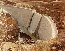
geology of the reservoir basin, with at least one of them 30 feet (9.1 m) in diameter and 35 feet (11 m) deep. The site's lack of "hydraulic integrity" was well known to Bureau scientists before and during construction.
314:
195:
as a water storage project. The 208-foot (63 m)-high dam structure impounds the water of the South Fork of Owl Creek, with the spillway as designed as a central overflow.
198:
During construction, the discovery of solution cavities in the bedrock forced the re-positioning and re-configuration of the dam, causing delays and added expense. The same
349:
329:
217:
The reservoir fills enough to provide some irrigation benefit through July and August of each season. It is operated by the local Owl Creek
Irrigation District.
209:
from filling its design capacity of 17,400 acre-feet (21,500,000 m). It has never been full. More than 50 sinkholes had been identified in the underlying
344:
261:
286:
64:
192:
339:
324:
181:
52:
319:
294:
185:
210:
334:
235:
308:
99:
79:
66:
202:
30:
132:
199:
127:
191:
The concrete thin-arch dam was completed in 1960 by the
315:
Buildings and structures in Hot
Springs County, Wyoming
236:"The Money Pit: Karst Failure of Anchor Dam, Wyoming"
167:
159:
154:
146:
138:
126:
121:
113:
105:
95:
58:
48:
40:
23:
262:"Anchor Dam: After A Decade And Millions Spent,…"
171:17,400 acre-feet (21,500,000 m) (designed)
8:
249:: 271–278 – via aquadoc.typepad.com.
29:
20:
350:Landforms of Hot Springs County, Wyoming
330:United States Bureau of Reclamation dams
226:
184:, about 35 miles (56 km) west of
7:
291:United States Bureau of Reclamation
243:Oklahoma Geological Survey Circular
193:United States Bureau of Reclamation
287:"Owl Creek Unit - Project Details"
18:Dam in Hot Springs County, Wyoming
14:
109:Operational, but not as designed
345:1960 establishments in Wyoming
1:
117:Owl Creek Irrigation District
260:Jean, Renée (July 8, 2024).
182:Hot Springs County, Wyoming
53:Hot Springs County, Wyoming
366:
28:
147:Height (foundation)
142:South Fork of Owl Creek
340:Dams completed in 1960
80:43.66410°N 108.82450°W
325:Reservoirs in Wyoming
297:on December 14, 2012.
234:Jarvis, Todd (2003).
128:Type of dam
150:208 feet (63 m)
85:43.66410; -108.82450
211:Chugwater Formation
168:Total capacity
76: /
266:Cowboy State Daily
203:solution cavities
175:
174:
122:Dam and spillways
357:
299:
298:
293:. Archived from
283:
277:
276:
274:
272:
257:
251:
250:
240:
231:
207:Anchor Reservoir
163:Anchor Reservoir
91:
90:
88:
87:
86:
81:
77:
74:
73:
72:
69:
33:
21:
365:
364:
360:
359:
358:
356:
355:
354:
320:Dams in Wyoming
305:
304:
303:
302:
285:
284:
280:
270:
268:
259:
258:
254:
238:
233:
232:
228:
223:
84:
82:
78:
75:
70:
67:
65:
63:
62:
36:
19:
12:
11:
5:
363:
361:
353:
352:
347:
342:
337:
332:
327:
322:
317:
307:
306:
301:
300:
278:
252:
225:
224:
222:
219:
173:
172:
169:
165:
164:
161:
157:
156:
152:
151:
148:
144:
143:
140:
136:
135:
130:
124:
123:
119:
118:
115:
111:
110:
107:
103:
102:
97:
93:
92:
60:
56:
55:
50:
46:
45:
42:
38:
37:
34:
26:
25:
17:
13:
10:
9:
6:
4:
3:
2:
362:
351:
348:
346:
343:
341:
338:
336:
333:
331:
328:
326:
323:
321:
318:
316:
313:
312:
310:
296:
292:
288:
282:
279:
267:
263:
256:
253:
248:
244:
237:
230:
227:
220:
218:
215:
212:
208:
204:
201:
196:
194:
189:
187:
183:
179:
170:
166:
162:
158:
153:
149:
145:
141:
137:
134:
131:
129:
125:
120:
116:
112:
108:
104:
101:
98:
94:
89:
61:
57:
54:
51:
47:
44:United States
43:
39:
32:
27:
22:
16:
295:the original
290:
281:
269:. Retrieved
265:
255:
246:
242:
229:
216:
206:
197:
190:
180:is a dam in
177:
176:
15:
186:Thermopolis
114:Operator(s)
83: /
71:108°49′28″W
59:Coordinates
309:Categories
221:References
205:prevented
178:Anchor Dam
100:Irrigation
68:43°39′51″N
35:Anchor Dam
24:Anchor Dam
335:Arch dams
155:Reservoir
139:Impounds
133:Arch dam
49:Location
271:July 6,
160:Creates
96:Purpose
41:Country
106:Status
239:(PDF)
200:karst
273:2024
247:109
311::
289:.
264:.
245:.
241:.
188:.
275:.
Text is available under the Creative Commons Attribution-ShareAlike License. Additional terms may apply.