34:
104:
111:
390:
476:, characterized by a very low average rainfall of less than 250 millimetres (9.8 in) per year. Precipitation falls in the summer, mostly in the form of rain. The average air temperature in January is a chilly −34 °C (−29 °F) with an absolute minimum of −60 °C (−76 °F). The temperature may reach a maximum of 38 °C (100 °F) in July. The average annual temperature is −14 °C (7 °F).
595:
402:
The Anabar
Plateau of the Central Siberian Plateau is one of the oldest structures on Earth, with rocks that are more than 3 billion years old. In its central region it is composed of Archean crystalline
342:, has its source in the plateau and flows in a northeastern direction. Rivers cut deep valleys or canyons, often flanked by scenic cliffs formed by very ancient eroded sediments. The
335:
type elevations running across the plateau area, mostly in a roughly east to west direction. The highest point is a 905 metres (2,969 ft) high unnamed summit.
331:, the border between both not being well-defined. The average height of the plateau surface is around 500 meters (1,600 ft). There are slightly higher
103:
635:
573:
630:
170:
33:
625:
163:
559:
599:
526:
383:
324:
209:
316:
354:
from the highest part of the Anabar
Plateau. Also to the southeast of the plateau is the source of the
312:
570:
473:
221:
435:
328:
241:
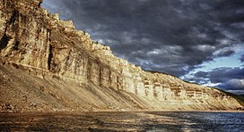
389:
332:
277:
152:
124:
577:
463:
439:
371:
299:. The permafrost thickness under the Anabar Plateau reaches 1,400 metres (4,600 ft).
147:
366:
of the
Olenyok basin have their sources at the southern end. To the northwest flows the
375:
367:
351:
320:
281:
202:
156:
39:
327:, to which it is connected in the southeast. To the southwest it runs into the higher
619:
431:
363:
355:
343:
308:
537:
548:
511:
443:
339:
412:
347:
230:
446:
further to the southeast, the Anabar Shield is one of the main features of the
610:
379:
296:
311:
in northeastern
Krasnoyarsk Krai and northwestern Sakha Republic, SSE of the
185:
172:
470:
419:
416:
254:
234:
350:
cuts from the south across the western side and is joined by its tributary
594:
359:
285:
273:
226:
447:
408:
404:
289:
250:
246:
140:
61:
462:
in the lower areas up to a height of 450 metres (1,480 ft) and
459:
388:
497:
346:
has its source in the northeastern sector of the plateau. River
611:
Fishing helicopter flight from
Khatanga to Kotuykan river
338:
The Big
Kuonamka, which forms the upper course of the
605:
430:
The Anabar
Plateau coincides geographically with the
560:
The
Archean Litosphere as seen in the Anabar Shield
358:, which flows east and then northeastwards. Rivers
240:
220:
215:
201:
162:
146:
136:
91:
83:
75:
70:
60:
52:
47:
21:
571:Brioflora of the Anabar Plateau and Adjacent Areas
466:with mosses and lichens in the higher altitudes.
469:The climate prevailing in the Anabar Plateau is
267:
8:
307:The Anabar Plateau is located north of the
378:. To the east lies the wider basin of the
295:The plateau is in a latitude dominated by
18:
498:Geological structure and relief of Taimyr
434:, a geological region that is an exposed
485:
323:and is the northernmost feature of the
493:
491:
489:
386:is located to the NNE of the plateau.
110:
521:
519:
411:. Along the periphery of the plateau
7:
507:
505:
14:
16:Mountain range in Siberia, Russia
593:
109:
102:
32:
636:Plateaus of the Sakha Republic
606:Anabar Information and history
1:
631:Landforms of Krasnoyarsk Krai
319:. It is located north of the
458:There are sparse forests of
652:
393:Anabar Plateau map section
315:, the central part of the
66:905 m (2,969 ft)
549:Anabar Plateau, Q & A
527:Great Soviet Encyclopedia
370:and to the northeast the
268:
96:
87:370 km (230 mi)
79:550 km (340 mi)
31:
26:
626:Central Siberian Plateau
384:Popigai impact structure
325:Central Siberian Plateau
210:Central Siberian Plateau
538:Аnаbаr - Kotuykan River
394:
317:North Siberian Lowland
392:
602:at Wikimedia Commons
442:. Together with the
182: /
576:2015-12-23 at the
395:
329:Putorana Mountains
186:70.500°N 108.000°E
48:Highest point
598:Media related to
525:Анабарское плато
454:Flora and climate
313:Taymyr Depression
260:
259:
164:Range coordinates
643:
597:
581:
568:
562:
557:
551:
546:
540:
535:
529:
523:
514:
509:
500:
495:
278:Krasnoyarsk Krai
272:) is a mountain
271:
270:
269:Анабарское плато
205:
197:
196:
194:
193:
192:
187:
183:
180:
179:
178:
175:
153:Krasnoyarsk Krai
125:Krasnoyarsk Krai
113:
112:
106:
42:, Anabar Plateau
36:
27:Анабарское плато
19:
651:
650:
646:
645:
644:
642:
641:
640:
616:
615:
590:
585:
584:
578:Wayback Machine
569:
565:
558:
554:
547:
543:
536:
532:
524:
517:
510:
503:
496:
487:
482:
464:mountain tundra
456:
440:Siberian Craton
428:
400:
372:Malaya Kuonamka
305:
203:
191:70.500; 108.000
190:
188:
184:
181:
176:
173:
171:
169:
168:
148:Federal subject
132:
131:
130:
129:
128:
121:
120:
119:
118:
114:
43:
17:
12:
11:
5:
649:
647:
639:
638:
633:
628:
618:
617:
614:
613:
608:
603:
600:Anabar Plateau
589:
588:External links
586:
583:
582:
563:
552:
541:
530:
515:
501:
484:
483:
481:
478:
455:
452:
427:
424:
422:predominate.
399:
396:
368:Khatanga River
321:Vilyuy Plateau
304:
301:
282:Sakha Republic
266:(Russian:
264:Anabar Plateau
258:
257:
244:
238:
237:
224:
218:
217:
213:
212:
207:
199:
198:
166:
160:
159:
157:Sakha Republic
150:
144:
143:
138:
134:
133:
122:
117:Anabar Plateau
116:
115:
108:
107:
101:
100:
99:
98:
97:
94:
93:
89:
88:
85:
81:
80:
77:
73:
72:
68:
67:
64:
58:
57:
54:
50:
49:
45:
44:
40:Kotuykan River
38:Cliffs by the
37:
29:
28:
24:
23:
22:Anabar Plateau
15:
13:
10:
9:
6:
4:
3:
2:
648:
637:
634:
632:
629:
627:
624:
623:
621:
612:
609:
607:
604:
601:
596:
592:
591:
587:
579:
575:
572:
567:
564:
561:
556:
553:
550:
545:
542:
539:
534:
531:
528:
522:
520:
516:
513:
508:
506:
502:
499:
494:
492:
490:
486:
479:
477:
475:
472:
467:
465:
461:
453:
451:
449:
445:
441:
437:
433:
432:Anabar Shield
426:Anabar Shield
425:
423:
421:
418:
414:
410:
406:
397:
391:
387:
385:
381:
377:
373:
369:
365:
364:Kyuyonelekeen
361:
357:
353:
349:
345:
344:Popigay River
341:
336:
334:
330:
326:
322:
318:
314:
310:
309:Arctic Circle
302:
300:
298:
293:
291:
287:
283:
279:
275:
265:
256:
252:
248:
245:
243:
239:
236:
232:
228:
225:
223:
219:
214:
211:
208:
206:
200:
195:
167:
165:
161:
158:
154:
151:
149:
145:
142:
139:
135:
126:
105:
95:
90:
86:
82:
78:
74:
69:
65:
63:
59:
55:
51:
46:
41:
35:
30:
25:
20:
580:(in Russian)
566:
555:
544:
533:
512:Google Earth
468:
457:
444:Aldan Shield
429:
401:
376:Anabar basin
340:Anabar River
337:
306:
294:
263:
261:
242:Type of rock
204:Parent range
123:Location in
474:continental
413:Proterozoic
284:(Yakutia),
231:Proterozoic
222:Age of rock
189: /
620:Categories
480:References
420:limestones
415:and Lower
297:permafrost
233:and Lower
71:Dimensions
471:subarctic
417:Paleozoic
333:tableland
303:Geography
255:Limestone
235:Paleozoic
92:Geography
62:Elevation
574:Archived
436:basement
409:gneisses
360:Kengeede
352:Kotuykan
280:and the
127:, Russia
438:of the
405:schists
398:Geology
374:of the
356:Olenyok
286:Siberia
274:plateau
227:Archean
216:Geology
177:108°0′E
174:70°30′N
137:Country
56:unnamed
448:craton
382:. The
290:Russia
251:schist
247:Gneiss
141:Russia
76:Length
460:larch
348:Kotuy
84:Width
407:and
380:Lena
362:and
262:The
253:and
155:and
53:Peak
292:.
276:in
622::
518:^
504:^
488:^
450:.
288:,
249:,
229:,
Text is available under the Creative Commons Attribution-ShareAlike License. Additional terms may apply.