523:, Angaur is a raised platform island. The profile of the island is a low table with very little relief. The highest point on the island, a small hill northwest of Rois, is only 40 m above sea level, and most of the island is less than 10 m above sea level. On the ground, however, the terrain is very rugged with steep, jagged outcrops of ancient reef rising unpredictably in a tangled maze. To the northwest the ground is slightly higher, and to the southeast the ground is slightly lower with marshy swamps across the
184:
395:
167:
407:
33:
238:
423:
frequently located in or around some of these stone platforms. The large quantities of shell recovered from archaeological sites gives evidence for an intensive exploitation of the limited lagoon surrounding the island and for collecting and fishing outside of the reef as well. On the island, the localized areas of soil were intensively used for garden plots.
415:
1104:
514:
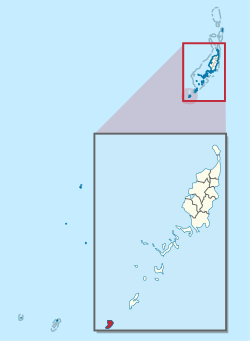
at the southern tip of the main group of islands in the archipelago, and is situated outside of the lagoon and enclosing reef for this main group. Angaur is surrounded by a thin reef which encloses a narrow lagoon, though for the most part the reef is so small and low that it offers little impediment
577:
were started in the rugged terrain in the northwest part of the island and along the east coast. These mines, started during the German administration, were in operation periodically for three administrations ending in the 1950s in the
American Period. The mined phosphate was initially processed and
422:
Angaur was traditionally divided among some eight clans. Traditional features within clan areas represent important symbols giving identity to families, clans and regions . These features include a variety of stone platforms with historical and traditional importance. Traditional cemeteries are
578:
loaded on ships at a small harbor on the west side of the island. Apparently this small natural harbor has been expanded during the course of phosphate mining. Also constructed with the harbor expansion was a lighthouse whose abandoned remains are situated on the high ground to the northwest.
666:
The island is connected by a network of roads. Secondary roads radiate out across the island and almost encircle it. On the east side of the island is a landing strip constructed during the
Japanese administration. Although unimproved, the 6600 foot runway known as the
901:
636:
However, the results of the 2005 census show that in April 2005 there were no usual or legal residents of Angaur aged 5 or older who spoke
Japanese at home at all. No residents of Anguar reported themselves or were reported as being of
653:
The state of Angaur, with population of less than 150, has an elected chief executive, governor. The state also has a legislature elected every two years. The state population elects one of the members of the
530:
Modern settlement on Angaur is concentrated on the west coast south of the harbor to a point of land called Bkul a Usas. Separated by lines of social division are the modern villages of Rois and
Ngaramasch.
914:
The traditional
Palauan language, particularly the dialect spoken by the people of Angaur State, shall be the language of the State of Angaur. Palauan, English and Japanese shall be the official languages.
694:
Angaur
Elementary School was established in 1945. A new building in another location opened in 1953. It moved to the original site in 1966 in a new building but it later moved back to the second site.
715:
Among other attractions are the cemetery of planes and ships that were destroyed in World War II, a
Buddhist memorial honoring the Japanese fallen in combat and a small Japanese Shinto shrine.
679:
during World War II. Unlike the battle of
Peleliu, however, Angaur received much less shelling before the invasion and the battle did not entail the tragic loss of life witnessed on Beliliou.
641:
ethnic origin. One person born (but apparently not residing) on Angaur reported to speak
Japanese and Palauan equally often at home. The 2012 mini census showed 7 people aged 10 or older
479:
that ran from June to Nov 1944. Many
American and Japanese battle relics remain scattered throughout the island. The 7th Antiaircraft Artillery Battalion under Lieutenant colonel
629:. At the time the constitution was written, many of the elders participating in the process had been educated in Japanese, as was the practice once Japan gained control of
1007:
594:
446:(The Reefs in Spanish). In November and December 1710, these three islands were again visited and explored by the Spanish missionary expedition commanded by
569:
Long before people came to this part of the Pacific Ocean, Angaur was a nesting ground for large numbers of birds whose droppings would eventually become
1156:
538:
forest (ironwood orngas trees). Surrounding the modern villages and many houses are garden plots and interspersed with these are small pockets of
483:
served as garrison forces for the remainder of the War. Angaur is the only place in Micronesia that has feral monkeys; they are descended from
807:
866:
937:
116:
467:
mining took place on Angaur, originally by the Germans, then the Japanese, and finally by Americans. Angaur is the site of a major
200:
1119:. Anthropology research series / Division of Cultural Affairs, Republic of Palau 2. San Francisco: U.S. National Park Service.
771:. Anthropology research series / Division of Cultural Affairs, Republic of Palau 2. San Francisco: U.S. National Park Service.
54:
183:
1149:
1068:
688:
1014:
675:
airport. The presence of the runway played an important role in the decision by the Americans to take Angaur along with
450:
982:
954:
549:
The island, which forms its own state, has an area of 8 km (3 mi). Its population was 130 in 2012. The state
655:
557:
on the western side. A second village, Rois, is immediately east of Ngeremasch. Angaur Island is located southwest of
97:
1084:
841:
439:
325:
69:
43:
1282:
1277:
1142:
76:
1060:
460:. Two years later they were explored in detail by the expedition of Spanish naval officer Bernardo de Egoy.
50:
166:
810:
399:
83:
359:
550:
394:
65:
734:
630:
960:(Report). Tokyo, Japan: National Institute for Japanese Language and Linguistics. pp. 85–86
534:
Most of Angaur is covered with a mixed limestone forest which includes several small stands of
515:
to the waves which break directly on the steep cliffs which ring the island. Distinct from the
1092:
933:
887:
697:
638:
614:
476:
351:
305:
700:
in Koror is the country's only public high school, so children from this community go there.
645:
in any language other than Palauan and English for Angaur, out of a total population of 130.
724:
610:
606:
472:
301:
297:
487:
that escaped during the period of German occupation. Thus it is also called Monkey Island.
1272:
1165:
1088:
1064:
814:
729:
709:
668:
495:
154:
542:(a variety of trees providing useful domestic products and foodstuffs). A large area of
708:
It is a very popular place for surfing. In 2003, the Palau National Congress legalized
574:
480:
447:
379:
171:
586:
The population of the state was 119 in the 2015 census and median age was 43.3 years.
502:
transmitting station, LORSTA Palau, as part of the worldwide LORAN navigation system.
1266:
90:
1226:
539:
516:
468:
406:
1114:
766:
927:
1216:
414:
32:
671:
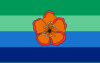
is used for the single-engine plane serving Angaur with daily flights from the
867:"2015 Census of Population, Housing and Agriculture for the Republic of Palau"
554:
253:
1108:
605:
According to the state constitution of 1982, Angaur's official languages are
215:
202:
17:
1191:
1039:
783:
A chronological history of the discoveries in the South Sea or Pacific Ocean
570:
535:
491:
464:
427:
312:
546:
swamp gardens known as Ngetkebui lies in the southern part of the island.
1251:
1236:
1231:
1221:
1211:
1206:
1196:
1176:
676:
642:
484:
335:
1081:
1246:
558:
511:
454:
435:
597:
Ucherbelau is the title of the traditional high chief from the state.
1241:
317:
1201:
1181:
1134:
1057:
672:
626:
524:
520:
510:
Angaur is a coralline island located some 10 km southwest of
499:
431:
413:
405:
393:
383:
243:
189:
1113:
Snyder, David.; Adams, William Hampton; Butler, Brian M. (1997).
765:
Snyder, David.; Adams, William Hampton; Butler, Brian M. (1997).
1129:
543:
1138:
817:
of Japanese command post on north end of Angaur Island, Palau.
592:
26:
953:
Long, Daniel; Imamura, Keisuke; Tmodrang, Masaharu (2013).
617:. It is the only place in the world where Japanese is a
438:
recorded by Westerners was by the Spanish expedition of
410:
Map of Angaur State with the Lukes (traditional place).
442:
at the end of January 1543. They were then charted as
1130:
Honorary Consulate of the Republic of Palau to the UK
498:. From 1945 to 1978 the U.S. Coast Guard operated a
490:
Angaur is accessible by boats and small planes, and
334:
324:
311:
293:
285:
277:
272:
264:
259:
249:
231:
134:
57:. Unsourced material may be challenged and removed.
1013:. Bureau of Budget & Planning. Archived from
573:deposits. In the early part of the 20th century,
475:was part of the larger offensive campaign called
826:Micronesia Handbook by Neil M. Levy, pp. 174–176
363:
1116:Archaeology and historic preservation in Palau
768:Archaeology and historic preservation in Palau
140:
1150:
977:
975:
794:Coello, Francisco "Conflicto hispano-alemán"
372:
8:
1157:
1143:
1135:
609:(and the Angauran dialect in particular),
378:in Palauan, is an island and state in the
131:
983:"2005 Census of Population & Housing"
836:
834:
832:
798:, t.XIX. 2º semestre 1885, Madrid, p.296.
117:Learn how and when to remove this message
796:Boletín de Sociedad Geográfica de Madrid
561:, and it is a popular surfing location.
746:
323:
310:
271:
258:
248:
230:
195:
180:
160:
904:. Pacific Digital Library. Article XII
902:"Constitution of the State of Angaur"
621:official language, as it is only the
333:
292:
284:
276:
263:
7:
1008:"2005 Census Monograph Final Report"
929:Encyclopedia of the Developing World
876:. Office of Planning and Statistics.
760:
758:
756:
754:
752:
750:
55:adding citations to reliable sources
1040:"State/National Election Schedule"
25:
1095:. Retrieved on February 22, 2018.
1071:. Retrieved on February 22, 2018.
988:. Bureau of Budget & Planning
888:"Council of Chiefs – PalauGov.pw"
847:. Bureau of Budget & Planning
1107: This article incorporates
1102:
418:Location of Angaur (upper right)
236:
182:
165:
31:
842:"2013 ROP Statistical Yearbook"
519:which lie between Beliliou and
294: • Official languages
42:needs additional citations for
955:The Japanese Language in Palau
426:The first sighting of Angaur,
1:
1069:Ministry of Education (Palau)
268:8 km (3 sq mi)
926:Leonard, Thomas M. (2006).
785:, London, 1813, v.I, p.233.
656:House of Delegates of Palau
589:History of the population:
364:
1299:
373:
1172:
1044:Palau Election Commission
691:operates public schools.
355:
196:
181:
161:
152:
141:
1058:Angaur Elementary School
932:. Taylor & Francis.
138:
440:Ruy López de Villalobos
1109:public domain material
419:
411:
403:
398:Map including Ngeaur (
188:Location of Angaur in
689:Ministry of Education
625:official language of
463:From 1909 until 1954
417:
409:
397:
320:(Palau Standard Time)
289:15/km (39/sq mi)
286: • Density
51:improve this article
216:6.9092°N 134.1388°E
212: /
1087:2018-03-03 at the
1063:2018-02-14 at the
1046:. 5 November 2020.
813:2014-12-19 at the
735:Peleliu Naval Base
631:South Seas Mandate
553:is the village of
458:Santísima Trinidad
420:
412:
404:
278: • Total
265: • Total
1260:
1259:
1093:Palau High School
1020:on 11 August 2014
698:Palau High School
477:Operation Forager
451:Francisco Padilla
344:
343:
127:
126:
119:
101:
16:(Redirected from
1290:
1283:Islands of Palau
1159:
1152:
1145:
1136:
1120:
1106:
1105:
1096:
1078:
1072:
1054:
1048:
1047:
1036:
1030:
1029:
1027:
1025:
1019:
1012:
1004:
998:
997:
995:
993:
987:
979:
970:
969:
967:
965:
959:
950:
944:
943:
923:
917:
916:
911:
909:
898:
892:
891:
884:
878:
877:
874:Palau Government
871:
863:
857:
856:
854:
852:
846:
838:
827:
824:
818:
808:Panoramio photos
805:
799:
792:
786:
779:
773:
772:
762:
725:Battle of Angaur
649:Political system
473:Battle of Angaur
453:on board of the
376:
375:
369:
367:
357:
242:
240:
239:
227:
226:
224:
223:
222:
221:6.9092; 134.1388
217:
213:
210:
209:
208:
205:
186:
169:
145:
144:
143:
132:
122:
115:
111:
108:
102:
100:
59:
35:
27:
21:
1298:
1297:
1293:
1292:
1291:
1289:
1288:
1287:
1278:States of Palau
1263:
1262:
1261:
1256:
1168:
1166:States of Palau
1163:
1126:
1112:
1103:
1100:
1099:
1089:Wayback Machine
1079:
1075:
1065:Wayback Machine
1055:
1051:
1038:
1037:
1033:
1023:
1021:
1017:
1010:
1006:
1005:
1001:
991:
989:
985:
981:
980:
973:
963:
961:
957:
952:
951:
947:
940:
925:
924:
920:
907:
905:
900:
899:
895:
886:
885:
881:
869:
865:
864:
860:
850:
848:
844:
840:
839:
830:
825:
821:
815:Wayback Machine
806:
802:
793:
789:
780:
776:
764:
763:
748:
743:
730:Angaur Airstrip
721:
712:on the island.
710:casino gambling
706:
685:
669:Angaur Airstrip
664:
651:
603:
595:
593:
584:
575:phosphate mines
567:
508:
496:Angaur Airstrip
494:has service to
392:
349:
304:
300:
237:
235:
220:
218:
214:
211:
206:
203:
201:
199:
198:
192:
177:
176:
175:
174:
157:
148:
146:
139:
137:
130:
123:
112:
106:
103:
60:
58:
48:
36:
23:
22:
15:
12:
11:
5:
1296:
1294:
1286:
1285:
1280:
1275:
1265:
1264:
1258:
1257:
1255:
1254:
1249:
1244:
1239:
1234:
1229:
1224:
1219:
1214:
1209:
1204:
1199:
1194:
1189:
1184:
1179:
1173:
1170:
1169:
1164:
1162:
1161:
1154:
1147:
1139:
1133:
1132:
1125:
1124:External links
1122:
1098:
1097:
1073:
1049:
1031:
999:
971:
945:
938:
918:
893:
879:
858:
828:
819:
800:
787:
781:Burney, James
774:
745:
744:
742:
739:
738:
737:
732:
727:
720:
717:
705:
702:
684:
681:
663:
660:
650:
647:
602:
599:
591:
583:
580:
566:
563:
507:
504:
481:Henry R. Paige
448:Sargento Mayor
391:
388:
342:
341:
338:
332:
331:
328:
322:
321:
315:
309:
308:
295:
291:
290:
287:
283:
282:
279:
275:
274:
270:
269:
266:
262:
261:
257:
256:
251:
247:
246:
233:
229:
228:
194:
193:
187:
179:
178:
170:
164:
163:
162:
159:
158:
153:
150:
149:
135:
129:State in Palau
128:
125:
124:
39:
37:
30:
24:
14:
13:
10:
9:
6:
4:
3:
2:
1295:
1284:
1281:
1279:
1276:
1274:
1271:
1270:
1268:
1253:
1250:
1248:
1245:
1243:
1240:
1238:
1235:
1233:
1230:
1228:
1225:
1223:
1220:
1218:
1215:
1213:
1210:
1208:
1205:
1203:
1200:
1198:
1195:
1193:
1190:
1188:
1185:
1183:
1180:
1178:
1175:
1174:
1171:
1167:
1160:
1155:
1153:
1148:
1146:
1141:
1140:
1137:
1131:
1128:
1127:
1123:
1121:
1118:
1117:
1110:
1094:
1090:
1086:
1083:
1077:
1074:
1070:
1066:
1062:
1059:
1053:
1050:
1045:
1041:
1035:
1032:
1016:
1009:
1003:
1000:
984:
978:
976:
972:
956:
949:
946:
941:
939:9780415976640
935:
931:
930:
922:
919:
915:
903:
897:
894:
889:
883:
880:
875:
868:
862:
859:
843:
837:
835:
833:
829:
823:
820:
816:
812:
809:
804:
801:
797:
791:
788:
784:
778:
775:
770:
769:
761:
759:
757:
755:
753:
751:
747:
740:
736:
733:
731:
728:
726:
723:
722:
718:
716:
713:
711:
703:
701:
699:
695:
692:
690:
682:
680:
678:
674:
670:
661:
659:
657:
648:
646:
644:
640:
634:
632:
628:
624:
620:
616:
612:
608:
600:
598:
590:
587:
581:
579:
576:
572:
564:
562:
560:
556:
552:
547:
545:
541:
537:
532:
528:
526:
522:
518:
513:
505:
503:
501:
497:
493:
488:
486:
482:
478:
474:
470:
466:
461:
459:
456:
452:
449:
445:
444:Los Arrecifes
441:
437:
433:
429:
424:
416:
408:
401:
396:
389:
387:
385:
381:
380:island nation
377:
366:
361:
353:
348:
339:
337:
336:ISO 3166 code
329:
327:
319:
316:
314:
307:
303:
299:
296:
288:
280:
267:
255:
252:
245:
234:
225:
197:Coordinates:
191:
185:
173:
168:
156:
151:
133:
121:
118:
110:
99:
96:
92:
89:
85:
82:
78:
75:
71:
68: –
67:
63:
62:Find sources:
56:
52:
46:
45:
40:This article
38:
34:
29:
28:
19:
18:Angaur Island
1227:Ngaremlengui
1186:
1115:
1101:
1076:
1052:
1043:
1034:
1022:. Retrieved
1015:the original
1002:
990:. Retrieved
962:. Retrieved
948:
928:
921:
913:
906:. Retrieved
896:
882:
873:
861:
849:. Retrieved
822:
803:
795:
790:
782:
777:
767:
714:
707:
696:
693:
686:
665:
652:
635:
622:
618:
604:
596:
588:
585:
568:
548:
533:
529:
517:rock islands
509:
489:
471:battle. The
469:World War II
462:
457:
443:
425:
421:
371:
346:
345:
113:
104:
94:
87:
80:
73:
61:
49:Please help
44:verification
41:
1217:Ngarchelong
527:landscape.
219: /
207:134°08′20″E
1267:Categories
741:References
582:Demography
555:Ngeremasch
540:agroforest
330:(+680) 277
273:Population
254:Ngeremasch
77:newspapers
1192:Hatohobei
683:Education
662:Transport
633:in 1914.
601:Languages
571:phosphate
565:Phosphate
536:casuarina
506:Geography
492:Belau Air
465:phosphate
428:Babeldaob
326:Area code
313:Time zone
204:6°54′33″N
107:June 2009
1252:Sonsorol
1237:Ngchesar
1232:Ngatpang
1222:Ngardmau
1212:Ngaraard
1207:Melekeok
1197:Kayangel
1177:Aimeliik
1085:Archived
1061:Archived
1024:4 August
992:4 August
964:July 11,
908:4 August
851:4 August
811:Archived
719:See also
677:Beliliou
643:literate
639:Japanese
623:de facto
615:Japanese
512:Beliliou
485:macaques
352:Japanese
306:Japanese
66:"Angaur"
1247:Peleliu
704:Tourism
619:de jure
611:English
607:Palauan
559:Peleliu
551:capital
525:karstic
455:patache
436:Peleliu
402:, 1991)
390:History
365:Angauru
360:Hepburn
302:English
298:Palauan
250:Capital
232:Country
147:Angauru
91:scholar
1273:Angaur
1242:Ngiwal
1187:Angaur
936:
434:, and
374:Ngeaur
347:Angaur
340:PW-010
241:
142:アンガウル州
136:Angaur
93:
86:
79:
72:
64:
1202:Koror
1182:Airai
1111:from
1082:About
1018:(PDF)
1011:(PDF)
986:(PDF)
958:(PDF)
870:(PDF)
845:(PDF)
673:Airai
627:Japan
521:Koror
500:LORAN
432:Koror
384:Palau
370:, or
356:アンガウル
318:UTC+9
244:Palau
190:Palau
155:State
98:JSTOR
84:books
1026:2014
994:2014
966:2022
934:ISBN
910:2014
853:2014
687:The
613:and
544:taro
260:Area
172:Flag
70:news
1091:."
1067:."
400:DMA
382:of
281:119
53:by
1269::
1042:.
974:^
912:.
872:.
831:^
749:^
658:.
430:,
386:.
362::
358:,
354::
1158:e
1151:t
1144:v
1080:"
1056:"
1028:.
996:.
968:.
942:.
890:.
855:.
368:)
350:(
120:)
114:(
109:)
105:(
95:·
88:·
81:·
74:·
47:.
20:)
Text is available under the Creative Commons Attribution-ShareAlike License. Additional terms may apply.