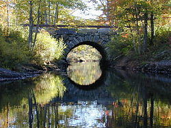
250:). Near its northern end, Benner Road crosses the river just below the outlet of Biscay Pond, providing access from the village to the northeastern part of the peninsula. The bridge it crosses on is a dry-laid stone arch structure with span of 14 feet (4.3 m) and a total length of 21 feet (6.4 m). It is built out of field stone and roughly quarried stone and river cobbles, with its base laid directly on bedrock. The top of the arch is about 14 feet (4.3 m) above the bedrock, and it is built up another 4 feet (1.2 m) to the paved roadway. The sides of the bridge are lined with granite curbing and modern wooden guardrails.
814:
48:
87:
62:
825:
94:
69:
253:
The actual construction date of the bridge is unknown, but circumstantial evidence and its construction methodology suggest a date before 1800. Town records before 1825 and after 1895 give no indication of funding for a bridge at this location. Benner Road is found on 1795 and 1815 maps of the
254:
area, and an 1857 map clearly identifies an arched bridge at this location. Its construction method is consistent with a similar bridge on Upper Round Pond Road (replaced with a metal culvert in 1984). The bridge has needed only modest repairs since its construction.
703:
798:
734:
718:
708:
849:
869:
263:
245:
The
Pemaquid River roughly bisects the peninsula on the Maine coast that the town of Bristol occupies. The village of Bristol Mills is located near the peninsula's geographic center, stretching out along Bristol Road
793:
739:
268:
380:
760:
662:
693:
627:
592:
667:
572:
532:
357:
632:
622:
617:
597:
713:
547:
462:
582:
577:
452:
672:
637:
542:
517:
657:
607:
587:
562:
552:
537:
527:
512:
492:
467:
457:
447:
677:
652:
557:
497:
477:
472:
442:
432:
612:
567:
507:
482:
437:
744:
642:
522:
487:
698:
647:
602:
502:
410:
395:
350:
426:
879:
828:
343:
131:
818:
86:
864:
390:
233:. Probably built before 1800, it is one of the state's oldest stone bridges, and is remarkably well-preserved for its age. It was listed on the
61:
874:
366:
296:
234:
34:
854:
781:
786:
765:
859:
400:
405:
385:
301:
247:
47:
318:
335:
230:
226:
119:
115:
201:
843:
799:
University and college buildings listed on the
National Register of Historic Places
222:
146:
133:
264:
National
Register of Historic Places listings in Lincoln County, Maine
794:
List of jails and prisons on the
National Register of Historic Places
269:
List of bridges on the
National Register of Historic Places in Maine
850:
Road bridges on the
National Register of Historic Places in Maine
291:
339:
870:
National
Register of Historic Places in Lincoln County, Maine
93:
68:
774:
753:
727:
686:
419:
396:
History of the
National Register of Historic Places
373:
207:
194:
186:
178:
170:
162:
125:
110:
427:List of U.S. National Historic Landmarks by state
819:National Register of Historic Places portal
351:
8:
358:
344:
336:
46:
367:U.S. National Register of Historic Places
35:U.S. National Register of Historic Places
880:Stone arch bridges in the United States
280:
313:
311:
292:"National Register Information System"
286:
284:
174:between 1780 and 1807(British Embargo)
18:
229:near the village of Bristol Mills in
7:
297:National Register of Historic Places
235:National Register of Historic Places
782:National Historic Preservation Act
14:
319:"NRHP nomination for Arch Bridge"
865:Bridges in Lincoln County, Maine
824:
823:
812:
225:, carrying Benner Road over the
92:
85:
67:
60:
735:Federated States of Micronesia
381:Architectural style categories
196:
1:
101:Show map of the United States
875:1857 establishments in Maine
16:United States historic place
896:
787:Historic Preservation Fund
766:American Legation, Morocco
182:Probably the Benner Family
855:Bridges completed in 1857
807:
728:Lists by associated state
195:NRHP reference
166:0.2 acres (0.081 ha)
54:
45:
41:
32:
25:
21:
709:Northern Mariana Islands
187:Architectural style
321:. National Park Service
241:Description and history
704:Minor Outlying Islands
687:Lists by insular areas
401:Keeper of the Register
406:National Park Service
386:Contributing property
302:National Park Service
248:Maine State Route 130
147:43.96222°N 69.50972°W
761:District of Columbia
221:is a historic stone
152:43.96222; -69.50972
143: /
837:
836:
391:Historic district
215:
214:
190:Stone arch bridge
76:Show map of Maine
887:
827:
826:
817:
816:
815:
740:Marshall Islands
360:
353:
346:
337:
330:
329:
327:
326:
315:
306:
305:
288:
198:
158:
157:
155:
154:
153:
148:
144:
141:
140:
139:
136:
102:
96:
95:
89:
77:
71:
70:
64:
50:
19:
895:
894:
890:
889:
888:
886:
885:
884:
840:
839:
838:
833:
813:
811:
803:
770:
749:
723:
682:
415:
369:
364:
334:
333:
324:
322:
317:
316:
309:
304:. July 9, 2010.
290:
289:
282:
277:
260:
243:
151:
149:
145:
142:
137:
134:
132:
130:
129:
118:on Benner Rd.,
106:
105:
104:
103:
100:
99:
98:
97:
80:
79:
78:
75:
74:
73:
72:
37:
28:
17:
12:
11:
5:
893:
891:
883:
882:
877:
872:
867:
862:
860:Bristol, Maine
857:
852:
842:
841:
835:
834:
832:
831:
821:
808:
805:
804:
802:
801:
796:
791:
790:
789:
778:
776:
772:
771:
769:
768:
763:
757:
755:
751:
750:
748:
747:
742:
737:
731:
729:
725:
724:
722:
721:
719:Virgin Islands
716:
711:
706:
701:
696:
694:American Samoa
690:
688:
684:
683:
681:
680:
675:
670:
665:
660:
655:
650:
645:
640:
635:
630:
628:South Carolina
625:
620:
615:
610:
605:
600:
595:
593:North Carolina
590:
585:
580:
575:
570:
565:
560:
555:
550:
545:
540:
535:
530:
525:
520:
515:
510:
505:
500:
495:
490:
485:
480:
475:
470:
465:
460:
455:
450:
445:
440:
435:
430:
423:
421:
420:Lists by state
417:
416:
414:
413:
411:Property types
408:
403:
398:
393:
388:
383:
377:
375:
371:
370:
365:
363:
362:
355:
348:
340:
332:
331:
307:
279:
278:
276:
273:
272:
271:
266:
259:
256:
242:
239:
231:Bristol, Maine
227:Pemaquid River
213:
212:
209:
205:
204:
199:
192:
191:
188:
184:
183:
180:
176:
175:
172:
168:
167:
164:
160:
159:
127:
123:
122:
120:Bristol, Maine
116:Pemaquid River
112:
108:
107:
91:
90:
84:
83:
82:
81:
66:
65:
59:
58:
57:
56:
55:
52:
51:
43:
42:
39:
38:
33:
30:
29:
26:
23:
22:
15:
13:
10:
9:
6:
4:
3:
2:
892:
881:
878:
876:
873:
871:
868:
866:
863:
861:
858:
856:
853:
851:
848:
847:
845:
830:
822:
820:
810:
809:
806:
800:
797:
795:
792:
788:
785:
784:
783:
780:
779:
777:
773:
767:
764:
762:
759:
758:
756:
752:
746:
743:
741:
738:
736:
733:
732:
730:
726:
720:
717:
715:
712:
710:
707:
705:
702:
700:
697:
695:
692:
691:
689:
685:
679:
676:
674:
671:
669:
668:West Virginia
666:
664:
661:
659:
656:
654:
651:
649:
646:
644:
641:
639:
636:
634:
631:
629:
626:
624:
621:
619:
616:
614:
611:
609:
606:
604:
601:
599:
596:
594:
591:
589:
586:
584:
581:
579:
576:
574:
573:New Hampshire
571:
569:
566:
564:
561:
559:
556:
554:
551:
549:
546:
544:
541:
539:
536:
534:
533:Massachusetts
531:
529:
526:
524:
521:
519:
516:
514:
511:
509:
506:
504:
501:
499:
496:
494:
491:
489:
486:
484:
481:
479:
476:
474:
471:
469:
466:
464:
461:
459:
456:
454:
451:
449:
446:
444:
441:
439:
436:
434:
431:
428:
425:
424:
422:
418:
412:
409:
407:
404:
402:
399:
397:
394:
392:
389:
387:
384:
382:
379:
378:
376:
372:
368:
361:
356:
354:
349:
347:
342:
341:
338:
320:
314:
312:
308:
303:
299:
298:
293:
287:
285:
281:
274:
270:
267:
265:
262:
261:
257:
255:
251:
249:
240:
238:
236:
232:
228:
224:
220:
210:
208:Added to NRHP
206:
203:
200:
193:
189:
185:
181:
177:
173:
169:
165:
161:
156:
128:
124:
121:
117:
113:
109:
88:
63:
53:
49:
44:
40:
36:
31:
24:
20:
633:South Dakota
623:Rhode Island
618:Pennsylvania
598:North Dakota
323:. Retrieved
295:
252:
244:
218:
216:
211:July 24 2018
754:Other areas
714:Puerto Rico
548:Mississippi
463:Connecticut
223:arch bridge
219:Arch Bridge
150: /
126:Coordinates
27:Arch Bridge
844:Categories
663:Washington
583:New Mexico
578:New Jersey
453:California
325:2016-02-10
275:References
138:69°30′35″W
135:43°57′44″N
673:Wisconsin
638:Tennessee
543:Minnesota
518:Louisiana
237:in 2003.
114:Over the
829:Category
658:Virginia
608:Oklahoma
588:New York
563:Nebraska
553:Missouri
538:Michigan
528:Maryland
513:Kentucky
493:Illinois
468:Delaware
458:Colorado
448:Arkansas
258:See also
202:03000618
179:Built by
111:Location
775:Related
678:Wyoming
653:Vermont
558:Montana
498:Indiana
478:Georgia
473:Florida
443:Arizona
433:Alabama
613:Oregon
568:Nevada
508:Kansas
483:Hawaii
438:Alaska
374:Topics
745:Palau
643:Texas
523:Maine
488:Idaho
171:Built
699:Guam
648:Utah
603:Ohio
503:Iowa
217:The
163:Area
197:No.
846::
310:^
300:.
294:.
283:^
429::
359:e
352:t
345:v
328:.
246:(
Text is available under the Creative Commons Attribution-ShareAlike License. Additional terms may apply.