647:
635:
659:
671:
162:
36:
169:
891:
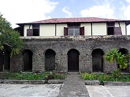
593:, adapted for a tropical climate. Surrounding the owner's house were the slave quarters, made of flimsy wood and roofed with branches and leaves. Each plantation also includes a terraced drying floor ('secadero') for coffee bean preparation and other buildings for milling and roasting.
588:
The plantations are in different states of preservation, from the
Cafetal Isabelica, which is fully restored, so some that are completely ruined. However, they all follow a similar layout. In the center of the plantation is the owner's residence, generally built in the style of
615:
in 1804 caused them to flee to Cuba, which was then under
Spanish rule. During the 19th century, many coffee plantations were established across the Sierra Maestra, but they were unable to compete with the coffee plantations of
342:
495:
242:
444:
546:
293:
393:
124:
202:
cultivation. The remnants of the plantations display the techniques used in the difficult terrain, as well as the economic and social significance of the plantation system in Cuba and the
Caribbean.
161:
646:
798:
634:
658:
217:
The World
Heritage site includes 171 19th and early 20th-century coffee plantations ('cafetales') across southeast Cuba, grouped into seven distinct locations:
670:
791:
911:
784:
849:
822:
859:
205:
In 2000, the
Archaeological Landscape of the First Coffee Plantations in the South-East of Cuba was added to the UNESCO list of
57:
835:
117:
25:
687:
628:
in the early 20th century, and gradually declined. Today, only a few coffee plantations are still in operation.
602:
62:
101:
168:
66:
874:
177:
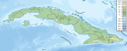
Location of
Archaeological Landscape of the First Coffee Plantations in the South-East of Cuba in Cuba
35:
807:
206:
77:
879:
437:
45:
192:
are the remains of several 19th-century coffee plantations located in the foothills of the
488:
868:
286:
193:
41:
607:
French colonizers established coffee plantations in the 18th century on the island of
905:
196:. During the 19th and early 20th centuries, eastern Cuba was primarily involved with
715:"Archaeological Landscape of the First Coffee Plantations in the South-East of Cuba"
845:
Archaeological
Landscape of the First Coffee Plantations in the South-East of Cuba
190:
Archaeological
Landscape of the First Coffee Plantations in the South-East of Cuba
20:
Archaeological
Landscape of the First Coffee Plantations in the South-East of Cuba
830:
758:
776:
839:
625:
608:
539:
562:
548:
511:
497:
460:
446:
409:
395:
358:
344:
309:
295:
258:
244:
139:
126:
621:
729:"World Heritage Committee Inscribes 61 New Sites on World Heritage List"
590:
386:
728:
90:
854:
714:
617:
198:
757:
International
Council on Monuments and Sites (15 September 1999).
612:
811:
70:
49:
40:
Cafetal La Isabelica, ancient coffee plantation in foothills of
780:
652:
Cafetal Isabelica, Drying place called secadero or tendal
116:
108:
96:
86:
76:
56:
24:
792:
8:
19:
676:Cafetal Isabelica, Interior of the property
799:
785:
777:
219:
34:
18:
664:Cafetal Isabelica, Tools and slave chains
752:
750:
748:
746:
709:
707:
705:
703:
640:Cafetal Isabelica, Mill to process beans
855:Old Havana and its Fortification System
699:
630:
112:81,475 ha (314.58 sq mi)
107:
95:
85:
75:
55:
7:
850:Desembarco del Granma National Park
823:Alejandro de Humboldt National Park
14:
889:
669:
657:
645:
633:
167:
160:
1:
912:World Heritage Sites in Cuba
860:San Pedro de la Roca Castle
928:
611:, but the independence of
600:
82:Cultural: (iii), (iv)
27:UNESCO World Heritage Site
886:
818:
688:Coffee production in Cuba
603:Coffee production in Cuba
337:Dos Palmas Contramaestre
155:
63:Santiago de Cuba Province
33:
759:Coffe Plantations (Cuba)
370:Dos Palmas Contramaestre
875:Valley de los Ingenios
836:Urban Historic Centre
563:20.21194°N 75.20000°W
512:20.14194°N 75.32667°W
461:20.29944°N 75.27333°W
410:20.35972°N 74.98028°W
359:20.04972°N 76.08361°W
310:20.05250°N 75.94333°W
259:20.01167°N 75.63083°W
140:20.03000°N 75.39139°W
808:World Heritage Sites
207:World Heritage Sites
16:UNESCO heritage site
591:Basque architecture
568:20.21194; -75.20000
558: /
517:20.14194; -75.32667
507: /
466:20.29944; -75.27333
456: /
415:20.35972; -74.98028
405: /
364:20.04972; -76.08361
354: /
315:20.05250; -75.94333
305: /
264:20.01167; -75.63083
254: /
145:20.03000; -75.39139
136: /
67:Guantánamo Province
21:
828:Historic Centre of
899:
898:
873:
865:
829:
586:
585:
186:
185:
919:
894:
893:
892:
871:
864:Santiago de Cuba
863:
827:
801:
794:
787:
778:
771:
770:
768:
766:
754:
741:
740:
738:
736:
725:
719:
718:
711:
673:
661:
649:
637:
582:
581:
579:
578:
577:
575:
570:
569:
564:
559:
556:
555:
554:
551:
531:
530:
528:
527:
526:
524:
519:
518:
513:
508:
505:
504:
503:
500:
480:
479:
477:
476:
475:
473:
468:
467:
462:
457:
454:
453:
452:
449:
429:
428:
426:
425:
424:
422:
417:
416:
411:
406:
403:
402:
401:
398:
378:
377:
375:
374:
373:
371:
366:
365:
360:
355:
352:
351:
350:
347:
329:
328:
326:
325:
324:
322:
317:
316:
311:
306:
303:
302:
301:
298:
278:
277:
275:
274:
273:
271:
266:
265:
260:
255:
252:
251:
250:
247:
220:
171:
170:
164:
151:
150:
148:
147:
146:
141:
137:
134:
133:
132:
129:
46:Santiago de Cuba
38:
28:
22:
927:
926:
922:
921:
920:
918:
917:
916:
902:
901:
900:
895:
890:
888:
884:
814:
805:
775:
774:
764:
762:
756:
755:
744:
734:
732:
727:
726:
722:
713:
712:
701:
696:
684:
677:
674:
665:
662:
653:
650:
641:
638:
605:
599:
573:
571:
567:
565:
561:
560:
557:
552:
549:
547:
545:
544:
522:
520:
516:
514:
510:
509:
506:
501:
498:
496:
494:
493:
471:
469:
465:
463:
459:
458:
455:
450:
447:
445:
443:
442:
420:
418:
414:
412:
408:
407:
404:
399:
396:
394:
392:
391:
369:
367:
363:
361:
357:
356:
353:
348:
345:
343:
341:
340:
320:
318:
314:
312:
308:
307:
304:
299:
296:
294:
292:
291:
269:
267:
263:
261:
257:
256:
253:
248:
245:
243:
241:
240:
237:La Gran Piedra
215:
182:
181:
180:
179:
178:
174:
173:
172:
144:
142:
138:
135:
130:
127:
125:
123:
122:
52:
26:
17:
12:
11:
5:
925:
923:
915:
914:
904:
903:
897:
896:
887:
885:
883:
882:
880:Viñales Valley
877:
866:
857:
852:
847:
842:
833:
825:
819:
816:
815:
806:
804:
803:
796:
789:
781:
773:
772:
742:
720:
698:
697:
695:
692:
691:
690:
683:
680:
679:
678:
675:
668:
666:
663:
656:
654:
651:
644:
642:
639:
632:
601:Main article:
598:
595:
584:
583:
542:
537:
533:
532:
491:
486:
482:
481:
440:
435:
431:
430:
389:
384:
380:
379:
338:
335:
331:
330:
289:
284:
280:
279:
270:La Gran Piedra
238:
235:
231:
230:
227:
224:
214:
211:
194:Sierra Maestra
184:
183:
176:
175:
166:
165:
159:
158:
157:
156:
153:
152:
120:
114:
113:
110:
106:
105:
98:
94:
93:
88:
84:
83:
80:
74:
73:
60:
54:
53:
42:Sierra Maestra
39:
31:
30:
15:
13:
10:
9:
6:
4:
3:
2:
924:
913:
910:
909:
907:
881:
878:
876:
870:
867:
861:
858:
856:
853:
851:
848:
846:
843:
841:
837:
834:
832:
826:
824:
821:
820:
817:
813:
809:
802:
797:
795:
790:
788:
783:
782:
779:
760:
753:
751:
749:
747:
743:
730:
724:
721:
716:
710:
708:
706:
704:
700:
693:
689:
686:
685:
681:
672:
667:
660:
655:
648:
643:
636:
631:
629:
627:
623:
619:
614:
610:
604:
596:
594:
592:
580:
543:
541:
538:
535:
534:
529:
492:
490:
487:
484:
483:
478:
441:
439:
436:
433:
432:
427:
390:
388:
385:
382:
381:
376:
339:
336:
333:
332:
327:
290:
288:
285:
282:
281:
276:
239:
236:
233:
232:
228:
225:
222:
221:
218:
212:
210:
208:
203:
201:
200:
195:
191:
163:
154:
149:
121:
119:
115:
111:
103:
99:
92:
89:
81:
79:
72:
68:
64:
61:
59:
51:
47:
43:
37:
32:
29:
23:
844:
763:. Retrieved
733:. Retrieved
723:
606:
587:
523:Niceto Pérez
489:Niceto Pérez
229:Coordinates
216:
204:
197:
189:
187:
566: /
515: /
472:El Salvador
464: /
438:El Salvador
413: /
362: /
313: /
262: /
213:Description
143: /
118:Coordinates
100:2000 (24th
97:Inscription
840:Cienfuegos
694:References
626:Costa Rica
609:Hispaniola
574:Guantanamo
572: (
553:75°12′00″W
550:20°12′43″N
540:Guantanamo
521: (
502:75°19′36″W
499:20°08′31″N
470: (
451:75°16′24″W
448:20°17′58″N
419: (
400:74°58′49″W
397:20°21′35″N
368: (
349:76°05′01″W
346:20°02′59″N
319: (
300:75°56′36″W
297:20°03′09″N
268: (
249:75°37′51″W
246:20°00′42″N
131:75°23′29″W
128:20°01′48″N
536:1008-007
485:1008-006
434:1008-005
383:1008-004
334:1008-003
283:1008-002
234:1008-001
87:Reference
906:Category
869:Trinidad
831:Camagüey
761:(Report)
731:. UNESCO
682:See also
622:Colombia
321:El Cobre
287:El Cobre
78:Criteria
58:Location
872:and the
597:History
421:Yateras
387:Yateras
102:Session
765:29 May
735:15 May
624:, and
618:Brazil
199:coffea
613:Haiti
226:Name
812:Cuba
767:2021
737:2015
188:The
109:Area
91:1008
71:Cuba
65:and
50:Cuba
838:of
810:in
223:ID
908::
862:,
745:^
702:^
620:,
209:.
69:,
48:,
44:,
800:e
793:t
786:v
769:.
739:.
717:.
576:)
525:)
474:)
423:)
372:)
323:)
272:)
104:)
Text is available under the Creative Commons Attribution-ShareAlike License. Additional terms may apply.