296:
136:
308:
143:
320:
29:
483:
At the end of August 1947 a devastating fire broke out on the southeastern slopes of the
Arnspitze as a result of extreme drought. The fire was fought for weeks by thousands of firemen from Upper Bavaria and Tyrol. This side of the mountain has remained bare ever since.
295:
447:) rock. Lead used to be mined at the foot of the Große Arnspitze. The mine lay on Bavarian territory just north of the Austrian border in the Isar valley, at the southwestern end of the Riedboden.
207:
307:
631:
250:. The majority of the group belongs to Tyrol, a northeastern part of the chain lies in Bavaria. The border between Bavaria and Tyrol runs over the summit of the
471:
in the district of
Innsbruck Land, is designated a nature reserve by the Tyrolean nature conservation law, and has an area of 10.8 km², and is the oldest
79:
135:
319:
621:
636:
616:
561:
626:
72:
463:
was established on 19 November 1942. That part which is nowadays in
Austria, on the territory of the municipalities of
472:
503:
408:
424:
189:
611:
537:
432:
301:
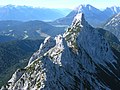
View from the Große
Arnspitze over the twin peaks of the Middle Arnspitze to the Arnplattenspitze
247:
62:
263:
376:
227:
565:
211:
558:
371:
on a partially exposed climbing route, the ridge path of the three peaks, including the
28:
456:
193:
182:
593:
583:
Naturinventar. Im
Auftrag der Abteilung Umweltschutz, Amt der Tiroler Landesregierung.
605:
440:
219:
174:
439:, which is 1682 m above sea level and lies south of the Arnspitze, is made of
364:
246:
in the east. In the literature, the
Arnspitze Group is classed as part of the
231:
218:) is a free-standing mountain chain in Austrian and Germany, in the states of
94:
81:
468:
368:
335:
There are no public roads in the region; only a very steep forest road from
243:
464:
384:
340:
235:
223:
395:. Below the summit at a height of 1,930 m is the unmanned hut of
313:
52:
423:). The Arnspitze Group is, for the most part, made up of rocks of
239:
355:
there are 5 paths to the individual summits. Whilst the
415:), only the northernmost part from the Riedberg ridge (
427:, which dip towards the southeast. In the area of the
540:. Amt der Tiroler Landesregierung, Abt. Umweltschutz
516:
181:
169:
161:
123:
115:
110:
71:
61:
51:
43:
38:
21:
500:Geologische Karte der Republik Österreich 1:50.000
411:and belongs tectonically to the Inn Valley range (
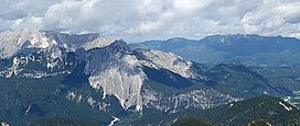
276:Arnplattenspitze (Hintere Arnspitze) (2171 m AMSL)
475:. The Bavarian part has an area of 1.7 km².
33:Summits of the Arnspitze Group from the south
8:
559:Alpenpark Karwendel Magazin 2006/06, p. 13 f
289:(along the main chain from the northwest)
18:
632:Mountain ranges of Tyrol (federal state)
527:But tiris gives its area as 11,659.22 ha
492:
379:standard. The most scenic route to the
291:
142:
7:
419:) is part of the Lech Valley range (
407:The Arnspitze Group is part of the
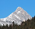
325:The Arnplattenspitze from the south
435:runs from west to east, while the
351:and from the hunting lodge on the
14:
318:
306:
294:
141:
134:
27:
375:requires climbing expertise of
16:Austrian-German mountain chain
1:
57:2,196 m (7,205 ft)
622:Mountain ranges of the Alps
581:Naturschutzgebiet Arnspitze
473:nature reserve in the Tyrol
363:may be reached either from
653:
637:Mountain ranges of Bavaria
617:Nature reserves in Austria
279:Weißlehnkopf (2002 m AMSL)
504:Federal Geological Office
455:The Arnspitze Group is a
367:via the Riedberg or from
177:(Innsbruck Land district)
128:
95:47.3971306°N 11.2225417°E
26:
461:Arnspitze Nature Reserve
451:Arnspitze Nature Reserve
285:Zwirchkopf (1773 m AMSL)
119:10 km (6.2 mi)
627:Innsbruck-Land District
594:hiking tour description
409:Northern Limestone Alps
339:in the municipality of
579:Oberhuber, W. (1995).
215:
100:47.3971306; 11.2225417
564:May 17, 2008, at the
425:Wetterstein limestone
347:. From the hamlet of
282:Arnkopf (1934 m AMSL)
190:Wetterstein Mountains
238:in the west and the
165:Germany and Austria
91: /
502:, Blatt 117 Zirl,
373:Mittlere Arnspitze
271:Mittlere Arnspitze
269:Middle Arnspitze (
248:Wettersteingebirge
234:, and between the
39:Highest point
199:
198:
644:
598:
568:
556:
550:
549:
547:
545:
534:
528:
525:
519:
513:
507:
497:
361:Arnplattenspitze
322:
310:
298:
228:Seefeld in Tirol
210:
185:
145:
144:
138:
106:
105:
103:
102:
101:
96:
92:
89:
88:
87:
84:
31:
19:
652:
651:
647:
646:
645:
643:
642:
641:
602:
601:
596:
590:
576:
571:
566:Wayback Machine
557:
553:
543:
541:
536:
535:
531:
526:
522:
514:
510:
506:, Vienna, 1992.
498:
494:
490:
481:
453:
417:Riedbergscharte
405:
389:Riedbergscharte
381:Große Arnspitze
357:Große Arnspitze
333:
331:Roads and paths
326:
323:
314:
311:
302:
299:
273:) (2091 m AMSL)
264:Große Arnspitze
260:
252:Große Arnspitze
236:Leutasch valley
206:
203:Arnspitze Group
183:
157:
156:
155:
154:
153:
152:
151:
150:
149:Arnspitze Group
146:
99:
97:
93:
90:
85:
82:
80:
78:
77:
47:Große Arnspitze
34:
22:Arnspitze Group
17:
12:
11:
5:
650:
648:
640:
639:
634:
629:
624:
619:
614:
604:
603:
600:
599:
589:
588:External links
586:
585:
584:
575:
572:
570:
569:
551:
529:
520:
508:
491:
489:
486:
480:
477:
457:nature reserve
452:
449:
433:Raibler strata
404:
401:
383:runs from the
332:
329:
328:
327:
324:
317:
315:
312:
305:
303:
300:
293:
287:
286:
283:
280:
277:
274:
267:
259:
256:
216:Arnspitzgruppe
197:
196:
194:Limestone Alps
192:; North Tyrol
187:
179:
178:
171:
167:
166:
163:
159:
158:
148:
147:
140:
139:
133:
132:
131:
130:
129:
126:
125:
121:
120:
117:
113:
112:
108:
107:
75:
69:
68:
67:Nature reserve
65:
59:
58:
55:
49:
48:
45:
41:
40:
36:
35:
32:
24:
23:
15:
13:
10:
9:
6:
4:
3:
2:
649:
638:
635:
633:
630:
628:
625:
623:
620:
618:
615:
613:
610:
609:
607:
595:
592:
591:
587:
582:
578:
577:
573:
567:
563:
560:
555:
552:
539:
533:
530:
524:
521:
517:
512:
509:
505:
501:
496:
493:
487:
485:
479:Fire disaster
478:
476:
474:
470:
466:
462:
458:
450:
448:
446:
442:
441:main dolomite
438:
434:
430:
426:
422:
418:
414:
410:
402:
400:
398:
397:Arnspitzhütte
394:
390:
386:
382:
378:
374:
370:
366:
362:
358:
354:
350:
346:
342:
338:
330:
321:
316:
309:
304:
297:
292:
290:
284:
281:
278:
275:
272:
268:
266:(2196 m AMSL)
265:
262:
261:
257:
255:
253:
249:
245:
241:
237:
233:
229:
225:
221:
217:
213:
209:
204:
195:
191:
188:
186:
180:
176:
172:
168:
164:
160:
137:
127:
122:
118:
114:
109:
104:
86:11°13′21.15″E
83:47°23′49.67″N
76:
74:
70:
66:
64:
60:
56:
54:
50:
46:
42:
37:
30:
25:
20:
580:
554:
542:. Retrieved
532:
523:
515:
511:
499:
495:
482:
460:
454:
445:Hauptdolomit
444:
436:
431:, a band of
429:Hoher Sattel
428:
421:Lechtaldecke
420:
416:
412:
406:
396:
392:
388:
380:
372:
360:
356:
353:Hoher Sattel
352:
348:
345:Hoher Sattel
344:
336:
334:
288:
270:
251:
202:
200:
184:Parent range
173:Bavaria and
612:Wetterstein
597:(in German)
538:"Arnspitze"
413:Inntaldecke
393:Achterköpfe
240:Isar valley
98: /
73:Coordinates
606:Categories
488:References
365:Mittenwald
232:Mittenwald
226:, between
111:Dimensions
544:13 August
518:, No. 5/1
469:Scharnitz
437:Zunteregg
387:over the
369:Scharnitz
244:Scharnitz
208:‹See Tfd›
162:Countries
124:Geography
53:Elevation
562:Archived
465:Leutasch
391:and the
385:Leutasch
377:grade II
359:and the
341:Leutasch
574:Sources
403:Geology
343:to the
224:Bavaria
63:Listing
459:. The
212:German
170:States
116:Length
258:Peaks
242:near
220:Tyrol
175:Tyrol
546:2010
467:and
349:Ahrn
337:Ahrn
230:and
222:and
201:The
44:Peak
608::
399:.
254:.
214::
548:.
443:(
205:(
Text is available under the Creative Commons Attribution-ShareAlike License. Additional terms may apply.