388:
441:
29:
502:
315:
507:
522:
425:
337:
56:
301:
360:
269:
517:
218:
478:
292:
207:
214:
in 1988, passes through the center of Bowman Dam. Due to this designation, hydropower production is currently not allowed at the dam.
527:
418:
323:
210:
in 1961, and is operated by the Ochoco
Irrigation District. The Crooked River wild and scenic area, which was designated by the
512:
297:
411:
28:
471:
225:
to access about 6 percent more water from the reservoir. As of May 2013, the Bowman Dam bill has not passed the
211:
345:
497:
238:
184:
104:
368:
273:
464:
226:
200:
196:
135:
39:
222:
448:
395:
387:
150:
491:
287:
188:
177:
71:
58:
440:
192:
43:
447:
This article about a dam or floodgate in the United States is a
180:
221:
passed a Bowman Dam bill, which would authorize the city of
394:
This article about a building or structure in Oregon is a
272:. NPDP Dam Directory, Stanford University. Archived from
452:
399:
159:
149:
141:
131:
126:
118:
110:
100:
95:
87:
50:
35:
21:
503:Buildings and structures in Crook County, Oregon
338:"For third time, House passes Bowman Dam bill"
472:
419:
8:
479:
465:
426:
412:
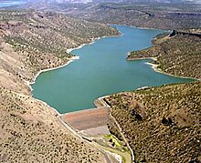
176:; National ID # OR00579) is an earth-type
27:
18:
508:United States Bureau of Reclamation dams
302:United States Department of the Interior
250:
264:
262:
260:
258:
256:
254:
7:
437:
435:
384:
382:
361:"House Passes Prineville Water Bill"
359:Nogueras, David (October 30, 2013).
344:. September 18, 2014. Archived from
523:Oregon building and structure stubs
293:Geographic Names Information System
208:United States Bureau of Reclamation
451:. You can help Knowledge (XXG) by
398:. You can help Knowledge (XXG) by
217:In 2013, for the second time, the
155:2,300 square miles (5,960 km)
14:
145:233,150 acre-feet (0.288 km)
439:
386:
298:United States Geological Survey
206:The dam was constructed by the
1:
518:1961 establishments in Oregon
219:U.S. House of Representatives
544:
434:
381:
199:. Its reservoir is called
163:3,580 acres (14.5 km)
212:Bureau of Land Management
26:
528:United States dam stubs
239:List of lakes in Oregon
513:Dams completed in 1961
270:"Arthur R. Bowman Dam"
72:44.11222°N 120.78667°W
320:Bureau of Reclamation
316:"Arthur R Bowman Dam"
122:800 feet (244 m)
201:Prineville Reservoir
170:Arthur R. Bowman Dam
136:Prineville Reservoir
114:245 feet (75 m)
77:44.11222; -120.78667
22:Arthur R. Bowman Dam
151:Catchment area
142:Total capacity
68: /
16:Dam in Oregon, U.S.
460:
459:
407:
406:
167:
166:
160:Surface area
96:Dam and spillways
88:Opening date
535:
481:
474:
467:
443:
436:
428:
421:
414:
390:
383:
373:
372:
367:. Archived from
356:
350:
349:
334:
328:
327:
322:. Archived from
312:
306:
305:
284:
278:
277:
266:
83:
82:
80:
79:
78:
73:
69:
66:
65:
64:
61:
31:
19:
543:
542:
538:
537:
536:
534:
533:
532:
488:
487:
486:
485:
433:
432:
379:
377:
376:
358:
357:
353:
336:
335:
331:
314:
313:
309:
286:
285:
281:
268:
267:
252:
247:
235:
172:(also known as
76:
74:
70:
67:
62:
59:
57:
55:
54:
17:
12:
11:
5:
541:
539:
531:
530:
525:
520:
515:
510:
505:
500:
498:Dams in Oregon
490:
489:
484:
483:
476:
469:
461:
458:
457:
444:
431:
430:
423:
416:
408:
405:
404:
391:
375:
374:
371:on 2015-05-18.
351:
348:on 2015-04-06.
329:
326:on 2016-09-28.
307:
279:
276:on 2011-07-16.
249:
248:
246:
243:
242:
241:
234:
231:
165:
164:
161:
157:
156:
153:
147:
146:
143:
139:
138:
133:
129:
128:
124:
123:
120:
116:
115:
112:
108:
107:
102:
98:
97:
93:
92:
89:
85:
84:
52:
48:
47:
37:
33:
32:
24:
23:
15:
13:
10:
9:
6:
4:
3:
2:
540:
529:
526:
524:
521:
519:
516:
514:
511:
509:
506:
504:
501:
499:
496:
495:
493:
482:
477:
475:
470:
468:
463:
462:
456:
454:
450:
445:
442:
438:
429:
424:
422:
417:
415:
410:
409:
403:
401:
397:
392:
389:
385:
380:
370:
366:
362:
355:
352:
347:
343:
339:
333:
330:
325:
321:
317:
311:
308:
303:
299:
295:
294:
289:
283:
280:
275:
271:
265:
263:
261:
259:
257:
255:
251:
244:
240:
237:
236:
232:
230:
228:
224:
220:
215:
213:
209:
204:
202:
198:
194:
190:
186:
185:Crooked River
182:
179:
175:
171:
162:
158:
154:
152:
148:
144:
140:
137:
134:
130:
125:
121:
117:
113:
109:
106:
105:Crooked River
103:
99:
94:
90:
86:
81:
53:
49:
45:
41:
38:
34:
30:
25:
20:
453:expanding it
446:
400:expanding it
393:
378:
369:the original
364:
354:
346:the original
342:www.ktvz.com
341:
332:
324:the original
319:
310:
291:
288:"Bowman Dam"
282:
274:the original
216:
205:
197:Crook County
173:
169:
168:
40:Crook County
365:www.opb.org
227:U.S. Senate
195:. It is in
75: /
63:120°47′12″W
51:Coordinates
492:Categories
245:References
223:Prineville
189:U.S. state
178:irrigation
174:Bowman Dam
127:Reservoir
60:44°6′44″N
233:See also
101:Impounds
36:Location
187:in the
183:on the
132:Creates
193:Oregon
119:Length
111:Height
46:, U.S.
44:Oregon
449:stub
396:stub
91:1961
191:of
181:dam
494::
363:.
340:.
318:.
300:,
296:.
290:.
253:^
229:.
203:.
42:,
480:e
473:t
466:v
455:.
427:e
420:t
413:v
402:.
304:.
Text is available under the Creative Commons Attribution-ShareAlike License. Additional terms may apply.
