339:
74:
62:
423:
464:
416:
469:
449:
287:
454:
427:
206:
197:
280:
253:
378:
373:
202:
144:
84:
171:
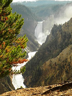
sketched his 1872 depictions of the falls. Later work determined that the sketches were made from the north rim, but the name
273:
61:
459:
323:
25:
296:
148:
119:
220:
Very steep or vertical slope (bluff, crag, head, headland, nose, palisades, precipice, promontory, rim, rimrock)
192:
338:
32:
223:
328:
123:
393:
383:
73:
403:
398:
249:
160:
156:
164:
388:
443:
363:
358:
265:
21:
318:
168:
368:
17:
99:
86:
306:
Geography, historic structures and other attractions in the Canyon area
152:
167:
who improperly believed that the point was the place at which painter
143:
is an overlook point on the edge of a cliff on the south rim of the
31:
For the unincorporated community in
Crawford County, Arkansas, see
52:
269:
248:. Gardiner, MT: Wonderland Publishing Company. p. 40.
346:
311:
130:
115:
40:
417:List of Yellowstone National Park related articles
163:. Artist Point was originally named in 1883 by
281:
8:
465:Tourist attractions in Park County, Wyoming
288:
274:
266:
37:
155:. The point is located east-northeast of
207:United States Department of the Interior
470:National Park Service rustic in Wyoming
184:
129:
114:
79:
70:
58:
450:Landforms of Yellowstone National Park
226:. Geographic Names Information System
7:
428:Yellowstone buildings and structures
422:
198:Geographic Names Information System
14:
455:Landforms of Park County, Wyoming
421:
337:
72:
60:
379:Grand Canyon of the Yellowstone
203:United States Geological Survey
145:Grand Canyon of the Yellowstone
1:
134:2,329 m (7,641 ft)
244:Whittlesey, Lee H. (2006).
224:"Feature Class Definitions"
486:
324:Chittenden Memorial Bridge
30:
26:Washington State Route 542
15:
412:
335:
304:
297:Yellowstone National Park
149:Yellowstone National Park
120:Yellowstone National Park
80:
71:
59:
50:
24:in Washington State, see
126:, Wyoming, United States
246:Yellowstone Place Names
312:Structures and history
100:44.72111°N 110.47944°W
66:View from Artist Point
33:Artist Point, Arkansas
16:For the view point of
347:Geography and geology
430:at Wikimedia Commons
105:44.72111; -110.47944
394:Yellowstone Caldera
384:Silver Cord Cascade
96: /
460:Cliffs of Wyoming
437:
436:
426:Media related to
404:Yellowstone River
399:Yellowstone Falls
374:Inspiration Point
329:Uncle Tom's Trail
161:Yellowstone River
157:Yellowstone Falls
138:
137:
477:
425:
424:
341:
290:
283:
276:
267:
260:
259:
241:
235:
234:
232:
231:
217:
211:
210:
189:
165:Frank Jay Haynes
111:
110:
108:
107:
106:
101:
97:
94:
93:
92:
89:
76:
64:
38:
485:
484:
480:
479:
478:
476:
475:
474:
440:
439:
438:
433:
408:
389:Whistler Geyser
342:
333:
307:
300:
294:
264:
263:
256:
243:
242:
238:
229:
227:
222:
218:
214:
191:
190:
186:
181:
104:
102:
98:
95:
90:
87:
85:
83:
82:
67:
55:
46:
43:
36:
29:
12:
11:
5:
483:
481:
473:
472:
467:
462:
457:
452:
442:
441:
435:
434:
432:
431:
419:
413:
410:
409:
407:
406:
401:
396:
391:
386:
381:
376:
371:
366:
361:
356:
350:
348:
344:
343:
336:
334:
332:
331:
326:
321:
315:
313:
309:
308:
305:
302:
301:
295:
293:
292:
285:
278:
270:
262:
261:
254:
236:
212:
193:"Artist Point"
183:
182:
180:
177:
136:
135:
132:
128:
127:
117:
113:
112:
78:
77:
69:
68:
65:
57:
56:
51:
48:
47:
44:
41:
13:
10:
9:
6:
4:
3:
2:
482:
471:
468:
466:
463:
461:
458:
456:
453:
451:
448:
447:
445:
429:
420:
418:
415:
414:
411:
405:
402:
400:
397:
395:
392:
390:
387:
385:
382:
380:
377:
375:
372:
370:
367:
365:
364:Dunraven Peak
362:
360:
359:Dunraven Pass
357:
355:
352:
351:
349:
345:
340:
330:
327:
325:
322:
320:
317:
316:
314:
310:
303:
298:
291:
286:
284:
279:
277:
272:
271:
268:
257:
255:1-59971-716-6
251:
247:
240:
237:
225:
221:
216:
213:
208:
204:
200:
199:
194:
188:
185:
178:
176:
174:
170:
166:
162:
158:
154:
150:
146:
142:
133:
125:
121:
118:
109:
81:Coordinates:
75:
63:
54:
49:
45:Lookout Point
42:Artist Point
39:
34:
27:
23:
22:Mount Shuksan
19:
354:Artist Point
353:
319:Canyon Hotel
245:
239:
228:. Retrieved
219:
215:
196:
187:
173:Artist Point
172:
169:Thomas Moran
141:Artist Point
140:
139:
369:Hedges Peak
124:Park County
103: /
91:110°28′46″W
18:Mount Baker
444:Categories
230:2012-08-18
88:44°43′16″N
131:Elevation
299:- Canyon
116:Location
175:stuck.
159:on the
153:Wyoming
252:
179:Notes
53:Cliff
250:ISBN
20:and
147:in
446::
205:,
201:.
195:.
151:,
122:,
289:e
282:t
275:v
258:.
233:.
209:.
35:.
28:.
Text is available under the Creative Commons Attribution-ShareAlike License. Additional terms may apply.