73:
81:
793:
781:
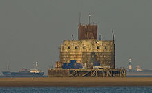
200:, to protect the sea entrance to the Humber Estuary. They stand 59 feet (18 m) above the water and have a diameter of 82 feet (25 m). There was accommodation for 200 soldiers. Started in May 1915, they took more than four years to build and construction was not finished until December 1919, a year after the war ended.
828:
207:
the forts were reactivated and modernised. They were regularly attacked by enemy aircraft. During this time, they installed submerged netting to prevent enemy submarines from travelling up the estuary to
803:
285:
In
February 2016 the fort was put on the market. It remained unsold until it was put up for auction in October 2018. It was sold for £117,000 at the auction to an unnamed purchaser.
243:, who intended to restore the fort for use as a drug rehabilitation facility. The plan failed eventually. The trust no longer operates. Administratively, it is within the
823:
725:
151:
107:
522:
838:
258:
In July 2022, it was listed for sale by auction, with a guide price of £50,000, through
Savills estate agents. The fort was sold for £490,000.
848:
658:
252:
415:
357:
410:
323:
228:. It is a 4-storey concrete building with 12-inch (300 mm) of armour on the seaward side, and originally armed with four
833:
529:
605:
797:
229:
785:
248:
240:
244:
34:
554:
267:
61:
853:
209:
56:
437:
673:
232:. It was built with great difficulty as its sandbank is 11 feet (3.4 m) below low water.
51:
406:
382:
353:
319:
204:
843:
494:
236:
197:
750:
698:
631:
579:
489:
266:
Haile Sand Fort or Sand Haile Fort is the smaller of the two and is situated around the
294:
97:
817:
93:
279:
271:
726:"This is how you can become the proud owner of an abandoned offshore war fort"
275:
225:
72:
17:
167:
153:
123:
109:
80:
46:
463:
792:
780:
606:"Ex naval sea fortress in Humber Estuary sells at auction for £490,000"
213:
79:
71:
808:
632:"WW1 Bull Sand Fort in Humber sold for nearly £500k at auction"
528:. East Riding of Yorkshire Council. p. 61. Archived from
523:"Southfield Farm Wind Turbine Landscape and Visual Assessment"
499:
580:"Bull Sand Fort: Humber defence to be sold to highest bidder"
804:
Humber Forts page on North East
Lincolnshire Council website
216:. The forts were finally abandoned by the military in 1956.
829:
Grade II listed buildings in the East Riding of
Yorkshire
224:
Bull Sand Fort is 1.5 miles (2.4 km) from shore off
196:
The two forts were planned in 1914, at the start of the
751:"Haile Sand fort in Humber estuary sold for £117,000"
555:"Bull Sandfort, Humber Estuary, Hull HU12 0UG"
8:
824:Buildings and structures in Lincolnshire
306:
699:"Haile Sand wartime fortress for sale"
362:Research records (formerly PastScape)
348:
346:
344:
328:Research records (formerly PastScape)
314:
312:
310:
7:
438:"Fort detox plan suffers cash blow"
416:National Heritage List for England
25:
724:Cawthorn, Joe (10 October 2018).
791:
779:
809:Island of Hope Charitable Trust
657:Oliver, Richard (August 2012).
490:"Drugs detox plan for WWI fort"
237:Grade II Listed Building status
1:
839:20th-century forts in England
470:. Streetwise Charitable Trust
358:"Haile Sands Fort (1429147)"
239:. In 1997 it was sold to the
849:World War I sites in England
383:"Bull Sand Fort (TA371092)"
241:Streetwise Charitable Trust
62:GPX (secondary coordinates)
870:
411:"Bull Sand Fort (1083477)"
324:"Bull Sand Fort (915963)"
57:GPX (primary coordinates)
32:Map all coordinates using
521:John Morris Associates.
464:"History of the Project"
245:East Riding of Yorkshire
40:Download coordinates as:
705:. BBC. 24 February 2016
672:: 33–45. Archived from
235:In 1987 it was given a
85:
77:
834:Grade II listed forts
100:in northern England:
83:
75:
52:GPX (all coordinates)
800:at Wikimedia Commons
788:at Wikimedia Commons
168:53.53444°N 0.03361°E
124:53.56194°N 0.06750°E
96:in the mouth of the
163: /
119: /
730:The Yorkshire Post
679:on 8 February 2022
535:on 31 January 2015
444:. 28 December 2005
86:
78:
796:Media related to
784:Media related to
757:. 1 November 2018
659:"Filling the gap"
468:An Island of Hope
173:53.53444; 0.03361
129:53.56194; 0.06750
16:(Redirected from
861:
795:
783:
767:
766:
764:
762:
747:
741:
740:
738:
736:
721:
715:
714:
712:
710:
695:
689:
688:
686:
684:
678:
663:
654:
648:
647:
645:
643:
628:
622:
621:
619:
617:
602:
596:
595:
593:
591:
576:
570:
569:
567:
565:
551:
545:
544:
542:
540:
534:
527:
518:
512:
511:
509:
507:
486:
480:
479:
477:
475:
460:
454:
453:
451:
449:
434:
428:
427:
425:
423:
407:Historic England
403:
397:
396:
394:
392:
387:
379:
373:
372:
370:
368:
354:Historic England
350:
339:
338:
336:
334:
320:Historic England
316:
205:Second World War
187:
186:
184:
183:
182:
180:
175:
174:
169:
164:
161:
160:
159:
156:
143:
142:
140:
139:
138:
136:
131:
130:
125:
120:
117:
116:
115:
112:
21:
869:
868:
864:
863:
862:
860:
859:
858:
814:
813:
798:Haile Sand Fort
776:
771:
770:
760:
758:
749:
748:
744:
734:
732:
723:
722:
718:
708:
706:
697:
696:
692:
682:
680:
676:
661:
656:
655:
651:
641:
639:
630:
629:
625:
615:
613:
610:Hull Daily Mail
604:
603:
599:
589:
587:
578:
577:
573:
563:
561:
553:
552:
548:
538:
536:
532:
525:
520:
519:
515:
505:
503:
495:BBC News Online
488:
487:
483:
473:
471:
462:
461:
457:
447:
445:
436:
435:
431:
421:
419:
405:
404:
400:
390:
388:
385:
381:
380:
376:
366:
364:
352:
351:
342:
332:
330:
318:
317:
308:
303:
291:
264:
262:Haile Sand Fort
222:
198:First World War
194:
179:Haile Sand Fort
178:
176:
172:
170:
166:
165:
162:
157:
154:
152:
150:
149:
146:Haile Sand Fort
134:
132:
128:
126:
122:
121:
118:
113:
110:
108:
106:
105:
76:Haile Sand Fort
70:
69:
68:
67:
66:
23:
22:
15:
12:
11:
5:
867:
865:
857:
856:
851:
846:
841:
836:
831:
826:
816:
815:
812:
811:
806:
801:
789:
786:Bull Sand Fort
775:
774:External links
772:
769:
768:
742:
716:
690:
649:
638:. 20 July 2022
623:
612:. 20 July 2022
597:
586:. 15 July 2022
571:
546:
513:
481:
455:
429:
398:
374:
340:
305:
304:
302:
299:
298:
297:
295:Maunsell Forts
290:
287:
268:low-water mark
263:
260:
221:
220:Bull Sand Fort
218:
193:
190:
135:Bull Sand Fort
102:Bull Sand Fort
98:Humber Estuary
94:fortifications
92:are two large
84:Bull Sand Fort
65:
64:
59:
54:
49:
43:
37:
30:
29:
28:
24:
18:Bull Sand Fort
14:
13:
10:
9:
6:
4:
3:
2:
866:
855:
852:
850:
847:
845:
842:
840:
837:
835:
832:
830:
827:
825:
822:
821:
819:
810:
807:
805:
802:
799:
794:
790:
787:
782:
778:
777:
773:
756:
752:
746:
743:
731:
727:
720:
717:
704:
700:
694:
691:
675:
671:
667:
660:
653:
650:
637:
633:
627:
624:
611:
607:
601:
598:
585:
581:
575:
572:
560:
556:
550:
547:
531:
524:
517:
514:
502:. 22 May 2006
501:
497:
496:
491:
485:
482:
469:
465:
459:
456:
443:
439:
433:
430:
418:
417:
412:
408:
402:
399:
384:
378:
375:
363:
359:
355:
349:
347:
345:
341:
329:
325:
321:
315:
313:
311:
307:
300:
296:
293:
292:
288:
286:
283:
281:
277:
273:
269:
261:
259:
256:
254:
250:
246:
242:
238:
233:
231:
227:
219:
217:
215:
211:
206:
201:
199:
191:
189:
185:
147:
141:
103:
99:
95:
91:
82:
74:
63:
60:
58:
55:
53:
50:
48:
45:
44:
42:
41:
36:
35:OpenStreetMap
33:
27:
19:
759:. Retrieved
754:
745:
733:. Retrieved
729:
719:
707:. Retrieved
702:
693:
681:. Retrieved
674:the original
669:
665:
652:
640:. Retrieved
635:
626:
614:. Retrieved
609:
600:
588:. Retrieved
583:
574:
562:. Retrieved
558:
549:
537:. Retrieved
530:the original
516:
504:. Retrieved
493:
484:
472:. Retrieved
467:
458:
446:. Retrieved
441:
432:
420:. Retrieved
414:
401:
389:. Retrieved
377:
365:. Retrieved
361:
331:. Retrieved
327:
284:
280:Lincolnshire
265:
257:
249:civil parish
234:
223:
202:
195:
145:
101:
90:Humber Forts
89:
87:
39:
38:
31:
26:
709:24 February
422:13 December
367:13 December
333:13 December
272:Cleethorpes
230:6-inch guns
203:During the
171: /
127: /
818:Categories
761:3 November
735:23 October
666:Sheetlines
539:31 January
301:References
276:Humberston
226:Spurn Head
177: (
133: (
111:53°33′43″N
854:Sea forts
559:RightMove
253:Easington
155:53°32′4″N
755:BBC News
703:BBC News
636:BBC News
584:BBC News
474:22 March
442:BBC News
391:22 March
289:See also
270:between
683:4 April
642:20 July
616:20 July
590:15 July
564:12 July
506:11 July
448:12 July
282:coast.
278:on the
214:Grimsby
192:History
158:0°2′1″E
114:0°4′3″E
844:Humber
144:) and
677:(PDF)
662:(PDF)
533:(PDF)
526:(PDF)
386:(PDF)
763:2018
737:2018
711:2016
685:2016
644:2022
618:2022
592:2022
566:2022
541:2015
508:2008
476:2013
450:2022
424:2012
393:2013
369:2012
335:2012
274:and
247:and
210:Hull
88:The
500:BBC
251:of
212:or
188:).
47:KML
820::
753:.
728:.
701:.
670:94
668:.
664:.
634:.
608:.
582:.
557:.
498:.
492:.
466:.
440:.
413:.
409:.
360:.
356:.
343:^
326:.
322:.
309:^
255:.
765:.
739:.
713:.
687:.
646:.
620:.
594:.
568:.
543:.
510:.
478:.
452:.
426:.
395:.
371:.
337:.
181:)
148:(
137:)
104:(
20:)
Text is available under the Creative Commons Attribution-ShareAlike License. Additional terms may apply.