529:
qualify for a
Traditional Authority of their own. Hosi Chavani was a son of the great Hosinkulu Nhjakanhjaka of Elim/Shirley community whose land starts at Elim and share a border with Bungeni village at a western boundary of Nwaxinyamani village. Hosi Chavani was deployed by his father, Hosi Nhjakanhjaka, with the main aim of expanding the Nhjakanhjaka's area of jurisdiction so that it covers the whole area up until it join Hosi Bungeni's land to the west at Nwaxinyamani village. Initially, the land of Hosinkulu Nhjakanhjaka covers the whole town of Elim and spread beyond Shirley village and covers the whole area known today as Mbhokota, Bokisi, Chavani and Riverplaats. The colonial and later apartheid government feared and always discouraged the formation of large scale Tsonga kingdoms all over South Africa. Because the land of Hosinkulu Nhjakanhjaka was too large the apartheid government divided his land, one at Elim to be ruled by Hosinkulu Nhjakanhjaka and one at Chavani village to be ruled by Hosi Chavani, in that case, a large scale Tsonga kingdom was dealt a blow because the land was divided in order to avoid aggression by Tsongas because a large Tsonga kingdom could not easily be controlled by colonial authorities. The people of Chavani village and their leader, Hosi Chavani Mukhari, approached Hosi Russel Bungeni for assistance. They ask that Hosi Russel Bungeni give away some of his people and his land to the people of Chavani so that Hosi Chavani may be recognized by the South African Government as a Senior traditional leader. Hosi Russel Bungeni agreed to help Hosi Chavani, he gave away Nwaxinyamani village to Hosi Chavani, with strict conditions, that Nwaxinyamani village must be returned to Hosi Russel Bungeni after Hosi Chavani has been recognized by the Government as a Senior Chief. After the transfer of Nwaxinyamani village into Hosi Chavani's land, Nkhensani Tribal Authority became established, in around 1965/66 and the South African Government immediately recognized Hosi Chavani as a Senior Traditional leader for the newly established Nkhensani Tribal Authority, with Nwaxinyamani village as one of Hosi Chavani's land. Thereafter, Tribal Office and a Community Health Centre was built for the people of Chavani by the Government. In around 1968, after Hosi Chavani has been recognized as a Senior Chief by the Government, Nwaxinyamani village has to be returned to Hosi Russel Bungeni but that agreement was not respected by Hosi Chavani, who continued to ignored the 1960 agreement between Hosi Russel Bungeni and himself, i.e. to hand over Nwaxinyamani village back to Hosi Russel Bungeni. It was not until recently, between 2015-2017 that the new Hosi Bungeni, started to engaged the new Hosi Chavani about the 1960 agreement that was entered into by both chief's grandparents. At the moment, both Hosi Chavani and Hosi Bungeni have finally agreed that Nwaxinyamani village must be returned to its old Tribal authority. Negotiations are currently under way between Hosi Bungeni and his former headman, Nwaxinyamani, to finally incorporate Nwaxinyamani village back to Bungeni Tribal Authority.
516:', who reports directly to Hosi Bungeni. In total, there are more than 22 sub-villages within Bungeni, each with its own 'Nduna' or headman according to their seniority , they are as follows; (1) Sekhunyani (2) Bungeni xikhulu (3) Mabodhlongwa (4)Makhome (5) Xitaci (6) Mtsetweni (7)Xihambanyisi (8) Nwa-Mhandzi (9) Xivambu (10) Njhakanjhaka A (e-Gembani) (11) Njhakanjhaka B (eXavunyami) (12) Wayeni (Bellevue) (13) Mahatlani (14) Nghonyama (New Village, established in 2010) (15) WisaGalaza (16) Dumani (Wayeni) (17) Manyunyu (18) Xingowa (19) Tana na Pulani (New Village, established in 2005) (20) Mandela (New Village, established in 2000) (21) Mahatlani new Stands (New Village, established in 2009) (22) Bungeni Big Tree Village (New Village, established in 2012).
126:
672:
143:
173:
22:
180:
150:
528:
In 1960, the South
African Government refused to recognize Hosi Chavani Mukhari as a traditional leader for the people of Chavani, Bokisi, Mbhokota and Riverplaats on the basis that the combined people of Chavani, Mbhokota, Bokisi, Riverplaats and their land are too small and therefore they do not
519:
All these sub-villages are collectively known as 'eka-Bungeni' and they fall under
Bungeni Traditional Authority, headquartered at Bungeni Xikhulu village, known to the locals as e-Tribal. About half of Bungeni Village is still empty land or unoccupied land, at full capacity, Bungeni village will be
537:
Bungeni has 5 secondary schools, which are Russel
Bungeni High School, Hluvuka High School, Marholeni Secondary School, Bellevue Secondary School and Mahatlani Secondary School. There are 12 primary schools at Bungeni. These are: Njhakanjhaka Primary, Muhluri Primary, Mkhono Higher Primary, Bungeni
484:
passing through it. With more than 30 000 people, Bungeni is the largest Tsonga village in
Makhado local municipality. In 1994 and in 2016, administrative control of this western portion of Gazankulu has been sub-divided in half and allocated to two Municipalities, first in 1994 to
520:
a home to more than 80 000 people by 2050. According to the 2015 mid-year population statistics, Bungeni has a population of approximately 30,000 people. The authority to demarcate residential stands, business sites and for any other purposes rest with Chief
Bungeni (Mabunda).
509:
Bungeni is a one Super village ruled by Hosi
Bungeni, broken down into 22 sub-villages. Hosi Bungeni has jurisdiction over these 22 sub-villages, these sub-villages are run by or presided over by 21 headmen or
497:. As of April 2016, the Western portion, known as 'Bungeni West' by the locals, has remained in Makhado local municipality, while the eastern portion, known as 'Bungeni east', has been allocated to the new
897:
125:
476:
agricultural plantation, where avocado, bananas, litchis, macadamia nuts, peaches and mangoes are grown in abundance is just 3km away north of
Bungeni village. It lies 35 km east of
602:
671:
538:
Primary, Xitaci
Primary, Mtsetweni Primary, Xihambanyisi Primary, Ndlavheya Primary, Nwa-Mhandzi Primary, Wayeni Primary, Mahatlani Primary and Masungi Primary.
595:
32:
588:
142:
427:
172:
683:
205:
47:
580:
317:
725:
612:
494:
260:
419:
90:
62:
793:
486:
270:
636:
481:
69:
76:
846:
339:
58:
738:
693:
644:
354:
343:
709:
717:
701:
689:
713:
469:
841:
743:
465:
440:
381:
392:
372:
891:
831:
821:
83:
801:
461:
240:
566:
783:
627:
21:
826:
697:
498:
490:
220:
207:
758:
457:
410:
328:
876:
866:
861:
856:
811:
763:
753:
748:
660:
655:
816:
773:
768:
733:
616:
477:
250:
871:
851:
836:
778:
705:
649:
473:
415:
456:
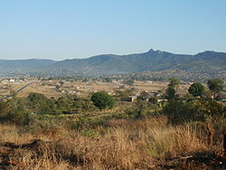
is a large sprawling rural settlement situated on top of one of the
584:
15:
670:
39:
43:
130:
A new village near
Bungeni Big tree, Bungeni Village
792:
724:
682:
635:
439:
426:
409:
401:
390:
379:
371:
363:
352:
337:
326:
315:
310:
302:
297:
289:
281:
276:
266:
256:
246:
236:
116:
898:Populated places in the Makhado Local Municipality
596:
8:
561:
559:
557:
555:
511:
48:introducing citations to additional sources
603:
589:
581:
113:
38:Relevant discussion may be found on the
551:
438:
425:
408:
370:
309:
296:
288:
275:
235:
200:
134:
122:
400:
389:
378:
362:
351:
336:
325:
314:
301:
280:
265:
255:
245:
7:
524:Nwaxinyamani village and the headman
285:10.94 km (4.22 sq mi)
675:Vhembe District within South Africa
611:Municipalities and communities of
14:
178:
171:
148:
141:
124:
31:relies largely or entirely on a
20:
179:
149:
111:Place in Limpopo, South Africa
1:
613:Vhembe District Municipality
914:
487:Makhado Local Municipality
293:700 m (2,300 ft)
668:
623:
201:
135:
123:
489:and in 2016, to the New
482:R578 road (South Africa)
192:Show map of South Africa
505:Sub-villages of Bungeni
676:
512:
696: (Hlanganani) •
674:
472:, South Africa. The
567:"Main Place Bungeni"
493:Municipality in the
460:and tail end of the
311:Racial makeup (2011)
44:improve this article
217: /
162:Show map of Limpopo
677:
402: • Other
364: • Other
303: • Total
282: • Total
885:
884:
451:
450:
221:23.206°S 30.224°E
109:
108:
94:
905:
663: (Tshipise)
605:
598:
591:
582:
575:
574:
563:
515:
470:Limpopo Province
232:
231:
229:
228:
227:
222:
218:
215:
214:
213:
210:
193:
182:
181:
175:
163:
152:
151:
145:
128:
114:
104:
101:
95:
93:
52:
24:
16:
913:
912:
908:
907:
906:
904:
903:
902:
888:
887:
886:
881:
842:Louis Trichardt
788:
720:
684:Collins Chabane
678:
666:
631:
625:District seat:
619:
609:
579:
578:
565:
564:
553:
548:
535:
526:
507:
495:Vhembe district
466:Louis Trichardt
447:
435:
373:First languages
226:-23.206; 30.224
225:
223:
219:
216:
211:
208:
206:
204:
203:
197:
196:
195:
194:
191:
190:
189:
188:
187:
183:
166:
165:
164:
161:
160:
159:
158:
157:
153:
131:
119:
112:
105:
99:
96:
53:
51:
37:
25:
12:
11:
5:
911:
909:
901:
900:
890:
889:
883:
882:
880:
879:
874:
869:
864:
859:
854:
849:
844:
839:
834:
829:
824:
819:
814:
809:
804:
798:
796:
790:
789:
787:
786:
781:
776:
771:
766:
761:
756:
751:
746:
741:
736:
730:
728:
722:
721:
688:
686:
680:
679:
669:
667:
665:
664:
658:
653:
652: (Musina)
647:
641:
639:
633:
632:
624:
621:
620:
610:
608:
607:
600:
593:
585:
577:
576:
550:
549:
547:
544:
543:
542:
534:
531:
525:
522:
506:
503:
501:Municipality.
449:
448:
445:
443:
437:
436:
433:
431:
424:
423:
413:
407:
406:
403:
399:
398:
395:
388:
387:
384:
377:
376:
369:
368:
365:
361:
360:
357:
350:
349:
346:
335:
334:
331:
324:
323:
320:
313:
312:
308:
307:
304:
300:
299:
295:
294:
291:
287:
286:
283:
279:
278:
274:
273:
268:
264:
263:
258:
254:
253:
248:
244:
243:
238:
234:
233:
199:
198:
185:
184:
177:
176:
170:
169:
168:
167:
155:
154:
147:
146:
140:
139:
138:
137:
136:
133:
132:
129:
121:
120:
117:
110:
107:
106:
42:. Please help
28:
26:
19:
13:
10:
9:
6:
4:
3:
2:
910:
899:
896:
895:
893:
878:
875:
873:
870:
868:
865:
863:
860:
858:
855:
853:
850:
848:
845:
843:
840:
838:
835:
833:
832:Laatsgevonden
830:
828:
825:
823:
822:Honingfontein
820:
818:
815:
813:
810:
808:
805:
803:
800:
799:
797:
795:
791:
785:
782:
780:
777:
775:
772:
770:
767:
765:
762:
760:
757:
755:
752:
750:
747:
745:
742:
740:
737:
735:
732:
731:
729:
727:
723:
719:
715:
711:
707:
703:
699:
695:
691:
687:
685:
681:
673:
662:
659:
657:
654:
651:
648:
646:
643:
642:
640:
638:
634:
630:
629:
622:
618:
614:
606:
601:
599:
594:
592:
587:
586:
583:
572:
568:
562:
560:
558:
556:
552:
545:
541:
540:
539:
532:
530:
523:
521:
517:
514:
504:
502:
500:
496:
492:
488:
483:
479:
475:
471:
467:
463:
459:
455:
444:
442:
432:
429:
421:
417:
414:
412:
404:
396:
394:
391: •
385:
383:
380: •
374:
366:
358:
356:
353: •
347:
345:
341:
338: •
332:
330:
327: •
321:
319:
318:Black African
316: •
305:
292:
284:
272:
269:
262:
259:
252:
249:
242:
239:
230:
202:Coordinates:
174:
144:
127:
115:
103:
100:November 2018
92:
89:
85:
82:
78:
75:
71:
68:
64:
61: –
60:
56:
55:Find sources:
49:
45:
41:
35:
34:
33:single source
29:This article
27:
23:
18:
17:
847:Olifantshoek
806:
802:Bandelierkop
710:Mutshikilini
626:
570:
536:
527:
518:
508:
464:mountain in
462:Soutpansberg
453:
452:
267:Municipality
241:South Africa
97:
87:
80:
73:
66:
54:
30:
784:Thohoyandou
628:Thohoyandou
571:Census 2011
480:, with the
428:Postal code
224: /
827:Kranspoort
739:Green Farm
698:Malamulele
645:Beitbridge
546:References
499:Malamulele
491:Malamulele
298:Population
212:30°13′26″E
209:23°12′22″S
70:newspapers
759:Makwarela
726:Thulamela
718:Tshilamba
694:Spelonken
533:Education
458:foothills
411:Time zone
290:Elevation
59:"Bungeni"
40:talk page
892:Category
877:Waterval
867:Valdezia
862:Tshitale
857:Tshikota
812:Buysdorp
764:Maranzhe
754:Makumeke
749:Lwamondo
702:Mapakoni
690:Dzimauli
656:Shakadza
430:(street)
329:Coloured
257:District
247:Province
817:Dzanani
807:Bungeni
794:Makhado
774:Shigalo
769:Nyavani
734:Duthuni
714:Thengwe
661:Chipise
650:Messina
617:Limpopo
513:tinduna
478:Makhado
454:Bungeni
271:Makhado
251:Limpopo
237:Country
186:Bungeni
156:Bungeni
118:Bungeni
84:scholar
872:Vuwani
852:Tiyani
837:Levubu
779:Sibasa
744:Josefa
706:Mutale
637:Musina
474:Levubu
441:PO box
382:Tsonga
375:(2011)
340:Indian
306:23 000
261:Vhembe
86:
79:
72:
65:
57:
416:UTC+2
393:Venda
386:90.3%
355:White
344:Asian
322:99.6%
91:JSTOR
77:books
420:SAST
405:2.5%
397:7.3%
367:0.1%
359:0.1%
348:0.1%
333:0.2%
277:Area
63:news
446:n/a
434:n/a
46:by
894::
716:•
712:•
708:•
704:•
700:•
692:•
615:,
569:.
554:^
468:,
604:e
597:t
590:v
573:.
510:'
422:)
418:(
342:/
102:)
98:(
88:·
81:·
74:·
67:·
50:.
36:.
Text is available under the Creative Commons Attribution-ShareAlike License. Additional terms may apply.